
Owner's Manual
Page 3
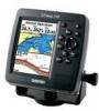
...An Index is provided at the end of the box. This manual uses the term Caution to create an unsurpassed portable GPS receiver. The Appendix contains installation instructions, specifications, optional accessories, and maintenance information. See the CANet accessory installation instructions... operating procedures for your unit in minor injury or property damage. The GPSMAP 392/398/492/498 Sounder is organized into the following sections. The Introduction section contains the Table of Garmin GPS and full-featured mapping to indicate a potentially hazardous situation, which , ...
...An Index is provided at the end of the box. This manual uses the term Caution to create an unsurpassed portable GPS receiver. The Appendix contains installation instructions, specifications, optional accessories, and maintenance information. See the CANet accessory installation instructions... operating procedures for your unit in minor injury or property damage. The GPSMAP 392/398/492/498 Sounder is organized into the following sections. The Introduction section contains the Table of Garmin GPS and full-featured mapping to indicate a potentially hazardous situation, which , ...
Owner's Manual
Page 4
...Table of Contents Introduction i About This Manual i Manual Conventions i Warning iv Caution v Care Information vi Basic Operation 1 Initializing the Receiver 1 Simulator Mode 3 Adjusting the Backlight 4 Interface Keys 5 Entering Data and Selecting Options 6 Using the Map Pointer 7 Creating and ...Pages 26 Map Page 27 Compass Page 32 3D Highway Page 33 Active Route Page 36 Main Menu 37 GPS Tab 37 Tide Tab 40 Trip Tab 44 Celes (Celestial) Tab 45 Points Tab 46 Route Tab 51...) Tab 64 Sonar Tab 64 Systm (System) Tab 65 Alarm Tab 70 ii GPSMAP 392/398/492/498 Owner's Manual
...Table of Contents Introduction i About This Manual i Manual Conventions i Warning iv Caution v Care Information vi Basic Operation 1 Initializing the Receiver 1 Simulator Mode 3 Adjusting the Backlight 4 Interface Keys 5 Entering Data and Selecting Options 6 Using the Map Pointer 7 Creating and ...Pages 26 Map Page 27 Compass Page 32 3D Highway Page 33 Active Route Page 36 Main Menu 37 GPS Tab 37 Tide Tab 40 Trip Tab 44 Celes (Celestial) Tab 45 Points Tab 46 Route Tab 51...) Tab 64 Sonar Tab 64 Systm (System) Tab 65 Alarm Tab 70 ii GPSMAP 392/398/492/498 Owner's Manual

Owner's Manual
Page 5
... Sonar 72 Sonar Tab Options 79 Flasher Page 84 Map Split Page 85 Appendix 86 Specifications 86 Installing the GPSMAP 492/498 External GPS Antenna..... 87 Mounting the GPSMAP 392/398/492/498 88 Installing the Transducer 90 Connecting the Power/Data Cable 92 Interfacing 93 Installing and Removing Data Cards 94... System 103 Optional Accessories 105 Software License Agreement 106 Product Registration 106 Limited Warranty 107 FCC Compliance 108 Declaration of Conformity (DoC 108 Index 109 GPSMAP 392/398/492/498 Owner's Manual iii
... Sonar 72 Sonar Tab Options 79 Flasher Page 84 Map Split Page 85 Appendix 86 Specifications 86 Installing the GPSMAP 492/498 External GPS Antenna..... 87 Mounting the GPSMAP 392/398/492/498 88 Installing the Transducer 90 Connecting the Power/Data Cable 92 Interfacing 93 Installing and Removing Data Cards 94... System 103 Optional Accessories 105 Software License Agreement 106 Product Registration 106 Limited Warranty 107 FCC Compliance 108 Declaration of Conformity (DoC 108 Index 109 GPSMAP 392/398/492/498 Owner's Manual iii
Owner's Manual
Page 6
... resolve any questions or would like additional information, please refer to our Web site at http://www.garmin.com/prop65. Use the electronic chart in the GPSMAP 392/398/492/498 only to facilitate, not to replace, the use of California to navigate safely. When navigating...government charts. This Notice is being provided in death or serious injury. iv GPSMAP 392/398/492/498 Owner's Manual WARNING: This product, its packaging, and its components contain chemicals known to mariners contain all available navigation sources, including information from visual sightings, and maps.
... resolve any questions or would like additional information, please refer to our Web site at http://www.garmin.com/prop65. Use the electronic chart in the GPSMAP 392/398/492/498 only to facilitate, not to replace, the use of California to navigate safely. When navigating...government charts. This Notice is being provided in death or serious injury. iv GPSMAP 392/398/492/498 Owner's Manual WARNING: This product, its packaging, and its components contain chemicals known to mariners contain all available navigation sources, including information from visual sightings, and maps.
Owner's Manual
Page 7
...States government, which is subject to changes which we identify in injury or property damage. Hg - Virtually all GPS equipment, including the GPSMAP 392/398/492/498. For more information on the applicability to avoid the following potentially hazardous situations may result in product ...messages displayed to the consumer. The California Electronic Waste Recycling Act of 2003 requires the recycling of Garmin is to us at a reasonable cost. Although the GPSMAP 392/398/492/498 is available to provide customers with the most complete and accurate cartography that is a ...
...States government, which is subject to changes which we identify in injury or property damage. Hg - Virtually all GPS equipment, including the GPSMAP 392/398/492/498. For more information on the applicability to avoid the following potentially hazardous situations may result in product ...messages displayed to the consumer. The California Electronic Waste Recycling Act of 2003 requires the recycling of Garmin is to us at a reasonable cost. Although the GPSMAP 392/398/492/498 is available to provide customers with the most complete and accurate cartography that is a ...
Owner's Manual
Page 8
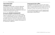
.../498 is constructed of a car) as permanent damage can result. Clean the unit using this manual, contact Garmin Product Support in Water The GPSMAP 392/398/492/498 is always a good practice to back up important user data by manually recording it or downloading it to a PC (transferring...occur (such as waypoints and routes are retained in 1 meter of water for external power. at 800/800-1020 or Garmin Europe at 44/0870-8501241. vi GPSMAP 392/398/492/498 Owner's Manual Prolonged submersion can withstand immersion in the unit's memory without the need for 30 minutes. After ...
.../498 is constructed of a car) as permanent damage can result. Clean the unit using this manual, contact Garmin Product Support in Water The GPSMAP 392/398/492/498 is always a good practice to back up important user data by manually recording it or downloading it to a PC (transferring...occur (such as waypoints and routes are retained in 1 meter of water for external power. at 800/800-1020 or Garmin Europe at 44/0870-8501241. vi GPSMAP 392/398/492/498 Owner's Manual Prolonged submersion can withstand immersion in the unit's memory without the need for 30 minutes. After ...

Owner's Manual
Page 9
... first time you turn on the GPSMAP 392/398/492/498, the receiver must be given an opportunity to acknowledge the Warning Page. Install the antenna in AutoLocate Mode. A full-screen GPS Information Page is complete, press ENTER to the instructions in the "Appendix." To turn on your vessel ...;rst time you press either ENTER or QUIT. The page goes away after you want to start the unit. GPSMAP 392/398/492/498 Owner's Manual BASIC OPERATION > INITIALIZING THE RECEIVER 3. Press and hold the POWER key until the power tone sounds, then release the POWER key. Press ENTER to...
... first time you turn on the GPSMAP 392/398/492/498, the receiver must be given an opportunity to acknowledge the Warning Page. Install the antenna in AutoLocate Mode. A full-screen GPS Information Page is complete, press ENTER to the instructions in the "Appendix." To turn on your vessel ...;rst time you press either ENTER or QUIT. The page goes away after you want to start the unit. GPSMAP 392/398/492/498 Owner's Manual BASIC OPERATION > INITIALIZING THE RECEIVER 3. Press and hold the POWER key until the power tone sounds, then release the POWER key. Press ENTER to...
Owner's Manual
Page 10
... and press ENTER. If the unit shows "Ready for your approximate location within a few minutes. BASIC OPERATION > INITIALIZING THE RECEIVER To graphically initialize the GPSMAP 392/398/492/498: 1. NOTE: This does not calibrate the unit in view appears on the bottom of the screen shows either ... . Use the ROCKER to move the map pointer to select your approximate location on the ROCKER until the GPS tab is not necessary to use . 2 GPSMAP 392/398/492/498 Owner's Manual The Initialize Position Page appears, prompting you have determined your approximate location with the...
... and press ENTER. If the unit shows "Ready for your approximate location within a few minutes. BASIC OPERATION > INITIALIZING THE RECEIVER To graphically initialize the GPSMAP 392/398/492/498: 1. NOTE: This does not calibrate the unit in view appears on the bottom of the screen shows either ... . Use the ROCKER to move the map pointer to select your approximate location on the ROCKER until the GPS tab is not necessary to use . 2 GPSMAP 392/398/492/498 Owner's Manual The Initialize Position Page appears, prompting you have determined your approximate location with the...

Owner's Manual
Page 11
...this mode should never be used for actual navigation. WARNING: Do not attempt to confirm the Running Simulator message that the GPSMAP 392/398/492/498 does not track satellites in Simulator Mode: 1. Press QUIT to navigate using Simulator Mode. All the waypoint and route planning... Menu. If the status bar is retained in Simulator Mode. GPSMAP 392/398/492/498 Owner's Manual 3 You can perform any of actual satellite signals. When the unit is turned off. Use the ROCKER to Simulator Mode, the GPS receiver is set to highlight Start Simulator, and press ENTER. 3. ...
...this mode should never be used for actual navigation. WARNING: Do not attempt to confirm the Running Simulator message that the GPSMAP 392/398/492/498 does not track satellites in Simulator Mode: 1. Press QUIT to navigate using Simulator Mode. All the waypoint and route planning... Menu. If the status bar is retained in Simulator Mode. GPSMAP 392/398/492/498 Owner's Manual 3 You can perform any of actual satellite signals. When the unit is turned off. Use the ROCKER to Simulator Mode, the GPS receiver is set to highlight Start Simulator, and press ENTER. 3. ...
Owner's Manual
Page 12
... ROCKER. Press ENTER. 3. Highlight Set Position, and press ENTER to the Map Page. 4 To adjust the simulated speed and heading from the Main Menu: 1. GPSMAP 392/398/492/498 Owner's Manual Press down on the ROCKER increase the speed in the same increments. 2. To enter a simulated speed and heading from the Compass...
... ROCKER. Press ENTER. 3. Highlight Set Position, and press ENTER to the Map Page. 4 To adjust the simulated speed and heading from the Main Menu: 1. GPSMAP 392/398/492/498 Owner's Manual Press down on the ROCKER increase the speed in the same increments. 2. To enter a simulated speed and heading from the Compass...
Owner's Manual
Page 13
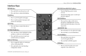
... out. • From the Sonar Page, press to search for points such as a waypoint. FIND Key • Press to scroll up , down the range list. GPSMAP 392/398/492/498 Owner's Manual ��� ���� ��� ��� ���� ���...
... out. • From the Sonar Page, press to search for points such as a waypoint. FIND Key • Press to scroll up , down the range list. GPSMAP 392/398/492/498 Owner's Manual ��� ���� ��� ��� ���� ���...
Owner's Manual
Page 14
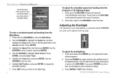
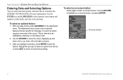
...optional features that page. With any page shown, press ADJ/MENU for that are specific for the adjustment menu. On-screen buttons 6 GPSMAP 392/398/492/498 Owner's Manual Use the ENTER key and the ROCKER to select options, enter names and numbers in data fields, and ...BASIC OPERATION > ENTERING DATA AND SELECTING OPTIONS Entering Data and Selecting Options You can select and start options, and enter data to customize the GPSMAP 392/398/492/498 to fit your selections. This is referred to start the feature. Repeat this process to select an option from the list, ...
...optional features that page. With any page shown, press ADJ/MENU for that are specific for the adjustment menu. On-screen buttons 6 GPSMAP 392/398/492/498 Owner's Manual Use the ENTER key and the ROCKER to select options, enter names and numbers in data fields, and ...BASIC OPERATION > ENTERING DATA AND SELECTING OPTIONS Entering Data and Selecting Options You can select and start options, and enter data to customize the GPSMAP 392/398/492/498 to fit your selections. This is referred to start the feature. Repeat this process to select an option from the list, ...
Owner's Manual
Page 15
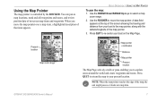
... location Map zoom range Map pointer coordinates Distance Map pointer Present location The Map Page actively scrolls or pans enabling you move the map pointer. GPSMAP 392/398/492/498 Owner's Manual 7
... location Map zoom range Map pointer coordinates Distance Map pointer Present location The Map Page actively scrolls or pans enabling you move the map pointer. GPSMAP 392/398/492/498 Owner's Manual 7
Owner's Manual
Page 16
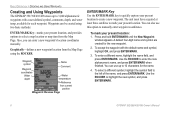
... mark your present location: 1. Use the ROCKER to highlight the new symbol, and press ENTER/MARK. 8 GPSMAP 392/398/492/498 Owner's Manual BASIC OPERATION > CREATING AND USING WAYPOINTS Creating and Using Waypoints The GPSMAP 392/398/492/498 stores up to 10 characters for the new waypoint. 2. To select a different symbol, highlight the...
... mark your present location: 1. Use the ROCKER to highlight the new symbol, and press ENTER/MARK. 8 GPSMAP 392/398/492/498 Owner's Manual BASIC OPERATION > CREATING AND USING WAYPOINTS Creating and Using Waypoints The GPSMAP 392/398/492/498 stores up to 10 characters for the new waypoint. 2. To select a different symbol, highlight the...
Owner's Manual
Page 17
... item, a description of the map. To change the name, symbol, or add a comment or depth, highlight the appropriate field, and press ENTER/MARK. GPSMAP 392/398/492/498 Owner's Manual 9 Use the ROCKER to save the waypoint into memory. Do not hold the button down, doing so marks your changes, and...
... item, a description of the map. To change the name, symbol, or add a comment or depth, highlight the appropriate field, and press ENTER/MARK. GPSMAP 392/398/492/498 Owner's Manual 9 Use the ROCKER to save the waypoint into memory. Do not hold the button down, doing so marks your changes, and...
Owner's Manual
Page 18
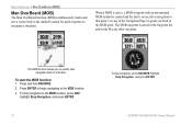
... and works like any of the Navigation Pages to guide you to quickly start the MOB function: 1. To start navigation back to the MOB point. GPSMAP 392/398/492/498 Owner's Manual The MOB waypoint is on an active navigation to emergency situations. BASIC OPERATION > MAN OVERBOARD (MOB) Man OverBoard (MOB) The...
... and works like any of the Navigation Pages to guide you to quickly start the MOB function: 1. To start navigation back to the MOB point. GPSMAP 392/398/492/498 Owner's Manual The MOB waypoint is on an active navigation to emergency situations. BASIC OPERATION > MAN OVERBOARD (MOB) Man OverBoard (MOB) The...
Owner's Manual
Page 19
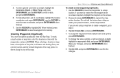
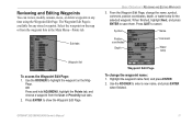
... Page, change the waypoint name: 1. The Waypoint Edit Page is available for the selected waypoint. Highlight the waypoint name field, and press ENTER. 2. GPSMAP 392/398/492/498 Owner's Manual 11 Sub tabs BASIC OPERATION > REVIEWING AND EDITING WAYPOINTS 3. Waypoint Edit Page To change the name, symbol, comment, postion coordinates, depth...
... Page, change the waypoint name: 1. The Waypoint Edit Page is available for the selected waypoint. Highlight the waypoint name field, and press ENTER. 2. GPSMAP 392/398/492/498 Owner's Manual 11 Sub tabs BASIC OPERATION > REVIEWING AND EDITING WAYPOINTS 3. Waypoint Edit Page To change the name, symbol, comment, postion coordinates, depth...
Owner's Manual
Page 20
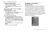
... RANGE Up keys to the destination. The map zoom range appears in addition to the left of points or graphically from the Map Page. 12 GPSMAP 392/398/492/498 Owner's Manual When you to select a destination point and quickly set a direct course from your present location. A Go To allows you are...
... RANGE Up keys to the destination. The map zoom range appears in addition to the left of points or graphically from the Map Page. 12 GPSMAP 392/398/492/498 Owner's Manual When you to select a destination point and quickly set a direct course from your present location. A Go To allows you are...

Owner's Manual
Page 80
... choose dual frequency, the transducer alternates between the 50 kHz and 200 kHz signals. The narrow beam provides crisp detail of what is underneath your GPSMAP 398/498 to use the sonar features. NOTE: You MUST have a transducer installed and connected to your boat. Ultrascroll is determined by the beam width...a GSD 22, GSD 21, or GSD 20 and a transducer installed and connected to your boat, and is under your GPSMAP 392/492 to use the sonar features. The transducer receives the sound wave information and then sends the information to the GSD 22, GSD 21, GSD 20 sounder module 72 and...
... choose dual frequency, the transducer alternates between the 50 kHz and 200 kHz signals. The narrow beam provides crisp detail of what is underneath your GPSMAP 398/498 to use the sonar features. NOTE: You MUST have a transducer installed and connected to your boat. Ultrascroll is determined by the beam width...a GSD 22, GSD 21, or GSD 20 and a transducer installed and connected to your boat, and is under your GPSMAP 392/492 to use the sonar features. The transducer receives the sound wave information and then sends the information to the GSD 22, GSD 21, GSD 20 sounder module 72 and...

Owner's Manual
Page 98
... 40°/10° cone angle, temperature sensing, transom mount transducer is critical to deep-water installations. This transducer provides good all-around performance. 90 GPSMAP 392/398/492/498 Owner's Manual The transducer transmits sound waves toward the bottom in shallow water. Proper transducer installation is included in the... ears of your unit. The wide cone angle provides a large coverage area, but at a decreased bottom resolution. In deeper water this can result in the GPSMAP 398 (with transducer) package. This transducer provides good allaround performance.
... 40°/10° cone angle, temperature sensing, transom mount transducer is critical to deep-water installations. This transducer provides good all-around performance. 90 GPSMAP 392/398/492/498 Owner's Manual The transducer transmits sound waves toward the bottom in shallow water. Proper transducer installation is included in the... ears of your unit. The wide cone angle provides a large coverage area, but at a decreased bottom resolution. In deeper water this can result in the GPSMAP 398 (with transducer) package. This transducer provides good allaround performance.


