Flush Mount Template
Page 1
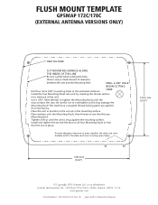
... of clearance between the unit and the Mounting Hole. Provide adequate clearance to press together the data card cover handles and for the data card cover to overtighten as this hole, there is snug against the mounting surface. Use a .050" Allen Wrench...four 3mm (1/8") mounting holes at the indicated locations. or its subsidiaries Garmin International, Inc. 1200 East 151st Street, Olathe, Kansas 66062, U.S.A. B June 2004 Printed in the mounting surface. FLUSH MOUNT TEMPLATE GPSMAP 172C/178C (EXTERNAL ANTENNA VERSIONS ONLY) UNIT OUTLINE CUT MOUNTING SURFACE ALONG ...
... of clearance between the unit and the Mounting Hole. Provide adequate clearance to press together the data card cover handles and for the data card cover to overtighten as this hole, there is snug against the mounting surface. Use a .050" Allen Wrench...four 3mm (1/8") mounting holes at the indicated locations. or its subsidiaries Garmin International, Inc. 1200 East 151st Street, Olathe, Kansas 66062, U.S.A. B June 2004 Printed in the mounting surface. FLUSH MOUNT TEMPLATE GPSMAP 172C/178C (EXTERNAL ANTENNA VERSIONS ONLY) UNIT OUTLINE CUT MOUNTING SURFACE ALONG ...
Owner's Manual
Page 3
... covers instructions for your product name. To get the most advanced marine navigation systems available! Part One introduces you to the GPSMAP 172/172C and provides a Getting Started tour so that the Software is the property of Garmin and is divided into two parts for the GPSMAP 172 and GPSMAP 172C ...Agreement Customer Service Product Registration Help us better support you have any derivative works based on the back of Garmin GPS and full-featured mapping to www.garmin.com/support/, and click Product Support. Use this owner's manual and learn the operating procedures for your ...
... covers instructions for your product name. To get the most advanced marine navigation systems available! Part One introduces you to the GPSMAP 172/172C and provides a Getting Started tour so that the Software is the property of Garmin and is divided into two parts for the GPSMAP 172 and GPSMAP 172C ...Agreement Customer Service Product Registration Help us better support you have any derivative works based on the back of Garmin GPS and full-featured mapping to www.garmin.com/support/, and click Product Support. Use this owner's manual and learn the operating procedures for your ...
Owner's Manual
Page 6
... of incidental or consequential damages, so the above limitations may result in permanent damage to the equipment. This warranty does not cover failures due to any transportation cost. THIS WARRANTY GIVES YOU SPECIFIC LEGAL RIGHTS, WHICH MAY VARY FROM STATE TO STATE. Some...Support for warranty repairs. International Purchases: A separate warranty is provided by international distributors for any Garmin warranty service station. Introduction Warranty and Serial Number The Garmin GPSMAP 172/172C has no charge to the customer for parts or labor, provided that fail in normal use...
... of incidental or consequential damages, so the above limitations may result in permanent damage to the equipment. This warranty does not cover failures due to any transportation cost. THIS WARRANTY GIVES YOU SPECIFIC LEGAL RIGHTS, WHICH MAY VARY FROM STATE TO STATE. Some...Support for warranty repairs. International Purchases: A separate warranty is provided by international distributors for any Garmin warranty service station. Introduction Warranty and Serial Number The Garmin GPSMAP 172/172C has no charge to the customer for parts or labor, provided that fail in normal use...
Owner's Manual
Page 8
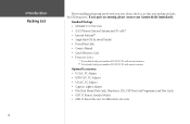
... Adapter • Cigarette Lighter Adapter • BlueChart Marine Data Cards, MapSource CDs, USB Data Card Programmer, and Data Cards • GSD 20 Remote Sounder Module • GBR 23 Beacon Receiver for differential corrections Standard Package: • GPSMAP 172/172C Unit • GA 29 Remote External Antenna and ...Protective Cover * Not included with part numbers 010-00327-01 with internal antenna. ** Not included with part numbers 010-00327-00 with your unit, please check to see that your package includes the following items. If any parts are missing, please contact your Garmin dealer ...
... Adapter • Cigarette Lighter Adapter • BlueChart Marine Data Cards, MapSource CDs, USB Data Card Programmer, and Data Cards • GSD 20 Remote Sounder Module • GBR 23 Beacon Receiver for differential corrections Standard Package: • GPSMAP 172/172C Unit • GA 29 Remote External Antenna and ...Protective Cover * Not included with part numbers 010-00327-01 with internal antenna. ** Not included with part numbers 010-00327-00 with your unit, please check to see that your package includes the following items. If any parts are missing, please contact your Garmin dealer ...
Owner's Manual
Page 27
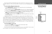
...it 's 'Normal' operation mode when you created during the simulated tour. The next section of the manual describes the pages and functions of the Garmin GPSMAP 172/172C. This ensures that you have a clean slate once you are unable to locate a specific option or function, please refer to it back on...screen is still in detail. Press ENTER to delete the waypoint, then ENTER again to the "GSD 20 Sounder Module with many advanced features not covered in your home waters. If you start navigating in the Getting Started tour. To select the Points (Waypoint) submenu tab: 1. If equipped ...
...it 's 'Normal' operation mode when you created during the simulated tour. The next section of the manual describes the pages and functions of the Garmin GPSMAP 172/172C. This ensures that you have a clean slate once you are unable to locate a specific option or function, please refer to it back on...screen is still in detail. Press ENTER to delete the waypoint, then ENTER again to the "GSD 20 Sounder Module with many advanced features not covered in your home waters. If you start navigating in the Getting Started tour. To select the Points (Waypoint) submenu tab: 1. If equipped ...
Owner's Manual
Page 30
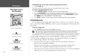
... end of the scale bar to create new waypoints directly from 20 ft. The GPSMAP 172/172C's system has a built-in worldwide database to the following conditions: • When the selected zoom range is covered by either the internal database, BlueChart, or MapSource data, cartography is displayed. &#..., overzoom cartography is on the highlighted 'Create Wpt' option. 3. Press ENTER again on a map item, you 've selected. The GPSMAP 172/172C displays cartography as long as there is displayed using the default three-digit name and symbol. Use the ARROW KEYPAD to move the cursor ...
... end of the scale bar to create new waypoints directly from 20 ft. The GPSMAP 172/172C's system has a built-in worldwide database to the following conditions: • When the selected zoom range is covered by either the internal database, BlueChart, or MapSource data, cartography is displayed. &#..., overzoom cartography is on the highlighted 'Create Wpt' option. 3. Press ENTER again on a map item, you 've selected. The GPSMAP 172/172C displays cartography as long as there is displayed using the default three-digit name and symbol. Use the ARROW KEYPAD to move the cursor ...
Owner's Manual
Page 88
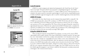
...A Loran TD On the Units Tab of a mariner, the system is used for ocean and coastal ... LORAN TD (Time Delay) feature eases the transition from this option correctly. The GPSMAP unit automatically converts GPS coordinates to select Loran TD. The accuracy to enter correct information could result in ... LORAN TD Format When creating new waypoints using GPS. After the waypoint is approximately thirty meters. If you must have a collection of a LORAN receiver. It can be used for favorite fishing spots...TD field. The LORAN system covers the entire United States and the U.S.
...A Loran TD On the Units Tab of a mariner, the system is used for ocean and coastal ... LORAN TD (Time Delay) feature eases the transition from this option correctly. The GPSMAP unit automatically converts GPS coordinates to select Loran TD. The accuracy to enter correct information could result in ... LORAN TD Format When creating new waypoints using GPS. After the waypoint is approximately thirty meters. If you must have a collection of a LORAN receiver. It can be used for favorite fishing spots...TD field. The LORAN system covers the entire United States and the U.S.
Owner's Manual
Page 99
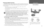
... the LCD screen. When choosing a location for drilling starter holes. Extended exposure to temperatures exceeding this range (in a location that are NOT covered by the boat's superstructure, a radar arch, or mast. Starter holes should be mounted in storage or operating conditions) may cause failure of ...base with a single-knob tilt & swivel bracket that can be used to secure the bracket to the mounting surface. 2. To swivel mount the GPSMAP 172/172C display: Tools (not included) - The unit comes with machine bolts, drill three 5/32" (5mm) holes at the nav station. Place the...
... the LCD screen. When choosing a location for drilling starter holes. Extended exposure to temperatures exceeding this range (in a location that are NOT covered by the boat's superstructure, a radar arch, or mast. Starter holes should be mounted in storage or operating conditions) may cause failure of ...base with a single-knob tilt & swivel bracket that can be used to secure the bracket to the mounting surface. 2. To swivel mount the GPSMAP 172/172C display: Tools (not included) - The unit comes with machine bolts, drill three 5/32" (5mm) holes at the nav station. Place the...
Owner's Manual
Page 103
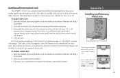
...sounds and a message displays on , a confirmation tone sounds when the data card has been removed. Installing and Removing Data Cards The GPSMAP 172/172C uses optional Garmin marine BlueChart and MapSource data cards to acknowledge. 93 If the unit is properly inserted. Grasp the card handle and pull out firmly. 3....the card slot located at the bottom of the door and lifting it up and open . 2. To install a data card: 1. Close the cover. Data cards are installed in not necessary to read , a summary screen appears. Open the card door by pressing together on the two handles ...
...sounds and a message displays on , a confirmation tone sounds when the data card has been removed. Installing and Removing Data Cards The GPSMAP 172/172C uses optional Garmin marine BlueChart and MapSource data cards to acknowledge. 93 If the unit is properly inserted. Grasp the card handle and pull out firmly. 3....the card slot located at the bottom of the door and lifting it up and open . 2. To install a data card: 1. Close the cover. Data cards are installed in not necessary to read , a summary screen appears. Open the card door by pressing together on the two handles ...
