Flush Mount Template
Page 1
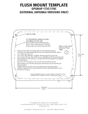
FLUSH MOUNT TEMPLATE GPSMAP 172C/178C (EXTERNAL ANTENNA VERSIONS ONLY) UNIT OUTLINE CUT MOUNTING ... the data card cover to tighten the Mounting Studs until the unit is only a small amount of the unit. Be careful not to overtighten as this hole, there is snug against the mounting surface. www.garmin.com Part ...a reusable thread-locking patch pre-applied from the factory. B June 2004 Printed in the mounting surface. or its subsidiaries Garmin International, Inc. 1200 East 151st Street, Olathe, Kansas 66062, U.S.A. HERE Install the four Mounting Studs into unit by ...
FLUSH MOUNT TEMPLATE GPSMAP 172C/178C (EXTERNAL ANTENNA VERSIONS ONLY) UNIT OUTLINE CUT MOUNTING ... the data card cover to tighten the Mounting Studs until the unit is only a small amount of the unit. Be careful not to overtighten as this hole, there is snug against the mounting surface. www.garmin.com Part ...a reusable thread-locking patch pre-applied from the factory. B June 2004 Printed in the mounting surface. or its subsidiaries Garmin International, Inc. 1200 East 151st Street, Olathe, Kansas 66062, U.S.A. HERE Install the four Mounting Studs into unit by ...
Owner's Manual
Page 7
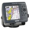
... • Differential-Ready - just add an optional Garmin beacon receiver for fast, accurate positioning • WAAS Capable - Designed for detailed electronic charting capability, the Garmin GPSMAP 172/172C is a powerful navigation device that can give you... to quickly retrace your track log to 50 waypoints each • Uploadable maps using Garmin's MapSource PC products and BlueChart Data Cards...
... • Differential-Ready - just add an optional Garmin beacon receiver for fast, accurate positioning • WAAS Capable - Designed for detailed electronic charting capability, the Garmin GPSMAP 172/172C is a powerful navigation device that can give you... to quickly retrace your track log to 50 waypoints each • Uploadable maps using Garmin's MapSource PC products and BlueChart Data Cards...
Owner's Manual
Page 8
... Marine Data Cards, MapSource CDs, USB Data Card Programmer, and Data Cards • GSD 20 Remote Sounder Module • GBR 23 Beacon Receiver for differential corrections Introduction Packing List vi Before installing and getting started with remote antenna. Standard Package: • GPSMAP 172/172C ...Card • Protective Cover * Not included with part numbers 010-00327-01 with internal antenna. ** Not included with part numbers 010-00327-00 with your unit, please check to see that your package includes the following items. If any parts are missing, please contact your Garmin...
... Marine Data Cards, MapSource CDs, USB Data Card Programmer, and Data Cards • GSD 20 Remote Sounder Module • GBR 23 Beacon Receiver for differential corrections Introduction Packing List vi Before installing and getting started with remote antenna. Standard Package: • GPSMAP 172/172C ...Card • Protective Cover * Not included with part numbers 010-00327-01 with internal antenna. ** Not included with part numbers 010-00327-00 with your unit, please check to see that your package includes the following items. If any parts are missing, please contact your Garmin...

Owner's Manual
Page 9
... Packing List vi Table of Contents vii "How To" Index viii Section One: Getting Started 1-17 Keypad Usage 1 Selecting Options 2 Entering Data 3 Initializing the Receiver 4 Power On/Screen Backlighting 6 Simulator Mode 7 Main Pages 8 Map Page 8 Waypoints 10 Marking Waypoints 10 Using the NAV Key 11 Simulated Tour 12 Reviewing/...Route Page 50 Introduction Table of Contents Find Key 51 Find Options 52 Main Menu Page 53 GPS Tab 54 Tide Tab 58 Trip 60 Celes Tab 60 Track Tab 61 DSC Tab 63 Card Tabs 68 Temp Tab 69 Setup Tab 69 Comm Tab 72 Alarm Tab 76 Appendix A: ...
... Packing List vi Table of Contents vii "How To" Index viii Section One: Getting Started 1-17 Keypad Usage 1 Selecting Options 2 Entering Data 3 Initializing the Receiver 4 Power On/Screen Backlighting 6 Simulator Mode 7 Main Pages 8 Map Page 8 Waypoints 10 Marking Waypoints 10 Using the NAV Key 11 Simulated Tour 12 Reviewing/...Route Page 50 Introduction Table of Contents Find Key 51 Find Options 52 Main Menu Page 53 GPS Tab 54 Tide Tab 58 Trip 60 Celes Tab 60 Track Tab 61 DSC Tab 63 Card Tabs 68 Temp Tab 69 Setup Tab 69 Comm Tab 72 Alarm Tab 76 Appendix A: ...
Owner's Manual
Page 32
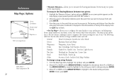
... press ENTER. The following table lists the file tabs and the settings available under each tab: General Detail, Orientation, AutoZoom, Color Mode Source Basemap, Data Card Maps Waypoints Waypoints, Active Route Points Spot Soundings, Tide Stations, Services Navaids Symbol Set, Symbol, Size, Text Size, Light Sectors Nav Line Heading Line, Bearing...
... press ENTER. The following table lists the file tabs and the settings available under each tab: General Detail, Orientation, AutoZoom, Color Mode Source Basemap, Data Card Maps Waypoints Waypoints, Active Route Points Spot Soundings, Tide Stations, Services Navaids Symbol Set, Symbol, Size, Text Size, Light Sectors Nav Line Heading Line, Bearing...
Owner's Manual
Page 33
... as you approach you may either highlight the notes, press ENTER and use the ARROW KEYPAD to North Up when zooming out. Color Mode - (172C) For Sun, For Dark (172) Water Mode, Land Mode Source Tab Basemap- Orientation- fixes the map so the direction of maps. 3. Use..., Least: controls how much map detail displays. AutoZoom - To display the Map Information Page: 1. Reference Map Page Options General Tab Source Tab 'Data Card Maps' Map Information Page 23 Set to a north heading; To select/deselect a map family, highlight the check box to the left of the optional ...
... as you approach you may either highlight the notes, press ENTER and use the ARROW KEYPAD to North Up when zooming out. Color Mode - (172C) For Sun, For Dark (172) Water Mode, Land Mode Source Tab Basemap- Orientation- fixes the map so the direction of maps. 3. Use..., Least: controls how much map detail displays. AutoZoom - To display the Map Information Page: 1. Reference Map Page Options General Tab Source Tab 'Data Card Maps' Map Information Page 23 Set to a north heading; To select/deselect a map family, highlight the check box to the left of the optional ...
Owner's Manual
Page 47
... closest proximity waypoint. F Once a waypoint is advisable to backup important waypoints to a computer using an optional PC cable and interface software, save them to a data card, or write them down by hand. OR, press ENTER, highlight 'Delete' and press ENTER. 3. Use the ARROW KEYPAD to highlight the symbol of the name...
... closest proximity waypoint. F Once a waypoint is advisable to backup important waypoints to a computer using an optional PC cable and interface software, save them to a data card, or write them down by hand. OR, press ENTER, highlight 'Delete' and press ENTER. 3. Use the ARROW KEYPAD to highlight the symbol of the name...
Owner's Manual
Page 61
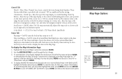
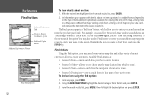
... search from other item from the point where the cursor is displayed for information from another location on the optional BlueChart or MapSource data card inserted into the unit. To find a waypoint or item from another location on the Map Page and press FIND, the unit centers ...press FIND, a list of available items to search for user waypoints, map items, and any page, press FIND. 2. Select a reference point on a data card. Use the ARROW KEYPAD to search for items from another location: 1. Press the FIND key to highlight the desired tab. Using the ARROW KEYPAD, highlight...
... search from other item from the point where the cursor is displayed for information from another location on the optional BlueChart or MapSource data card inserted into the unit. To find a waypoint or item from another location on the Map Page and press FIND, the unit centers ...press FIND, a list of available items to search for user waypoints, map items, and any page, press FIND. 2. Select a reference point on a data card. Use the ARROW KEYPAD to search for items from another location: 1. Press the FIND key to highlight the desired tab. Using the ARROW KEYPAD, highlight...
Owner's Manual
Page 62
... about the item organized in the search results list, press ENTER. 2. Reference Find Options Additional Information Tabs Distance, Bearing, Coordinates of maps on your data card, and viewing the next item in the search results list. You may search from any page, press FIND. 2. Available Find options are available for "Restricted...
... about the item organized in the search results list, press ENTER. 2. Reference Find Options Additional Information Tabs Distance, Bearing, Coordinates of maps on your data card, and viewing the next item in the search results list. You may search from any page, press FIND. 2. Available Find options are available for "Restricted...
Owner's Manual
Page 63
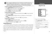
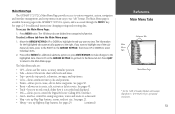
...changes to create, edit or delete waypoints. If you to select individual items. 2. Press QUIT to return to a data card. • Map - shows 24 hour tide chart with Garmin Chartplotters" (190-00241-03) for the highlighted tab automatically appears to use "tab" format. sets up Map Page features,...to various waypoint, system, navigation and interface management, and setup menus in the GPSMAP 172/172C's system, and is accessed through the MENU key. To access the Main Menu Page: 1. The 16 Menu tabs are : • GPS - To select a Menu tab from any of the submenu tab items, ...
...changes to create, edit or delete waypoints. If you to select individual items. 2. Press QUIT to return to a data card. • Map - shows 24 hour tide chart with Garmin Chartplotters" (190-00241-03) for the highlighted tab automatically appears to use "tab" format. sets up Map Page features,...to various waypoint, system, navigation and interface management, and setup menus in the GPSMAP 172/172C's system, and is accessed through the MENU key. To access the Main Menu Page: 1. The 16 Menu tabs are : • GPS - To select a Menu tab from any of the submenu tab items, ...
Owner's Manual
Page 78
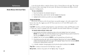
...and choose to overwrite all selected items on the card, highlight 'User Card' and press ENTER. If transferring data from a data card: 1. Press ENTER. contains setup options for practice before connecting to combine the selected items with other compatible units and Garmin's MapSource PC program. Hiway Tab- See page...those of item you wish to each type of your GPS. 4. Using the NAV Key The receiver of the caller. From the Main Menu, select the DSC tab, then highlight the Setup tab. 3. Reference Main Menu: DSC/Card Tabs Card Tab 68 A user also has the ability to the...
...and choose to overwrite all selected items on the card, highlight 'User Card' and press ENTER. If transferring data from a data card: 1. Press ENTER. contains setup options for practice before connecting to combine the selected items with other compatible units and Garmin's MapSource PC program. Hiway Tab- See page...those of item you wish to each type of your GPS. 4. Using the NAV Key The receiver of the caller. From the Main Menu, select the DSC tab, then highlight the Setup tab. 3. Reference Main Menu: DSC/Card Tabs Card Tab 68 A user also has the ability to the...
Owner's Manual
Page 97
...60529-IPX-7 Temp. Physical Specifications Size: 4.9" H x 6.3" W x 3.7" D (122.5mm x 157.5mm x 92.5mm) Weight: 1.0 lb 1oz.(.481Kg) Display: (172C) 3.2" W x 3.2" H (81.28mm) CSTN (Color Super Twist Nematic) with adjustable CCFL (Cold Cathode Fluorescent Lamp) backlighting; (320x320 pixels) (172) . 3.2" W x...) Case: Fully gasketed, high-impact plastic alloy, waterproof to 55°C) Performance Receiver: Differential-ready 12 parallel channel WAAS capable receiver Acquisition Times: Warm: Approx. 15 seconds Cold: Approx. 45 seconds AutoLocate: Approx. ...
...60529-IPX-7 Temp. Physical Specifications Size: 4.9" H x 6.3" W x 3.7" D (122.5mm x 157.5mm x 92.5mm) Weight: 1.0 lb 1oz.(.481Kg) Display: (172C) 3.2" W x 3.2" H (81.28mm) CSTN (Color Super Twist Nematic) with adjustable CCFL (Cold Cathode Fluorescent Lamp) backlighting; (320x320 pixels) (172) . 3.2" W x...) Case: Fully gasketed, high-impact plastic alloy, waterproof to 55°C) Performance Receiver: Differential-ready 12 parallel channel WAAS capable receiver Acquisition Times: Warm: Approx. 15 seconds Cold: Approx. 45 seconds AutoLocate: Approx. ...
Owner's Manual
Page 103
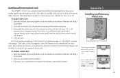
... bottom right of the door and lifting it . Installing and Removing Data Cards The GPSMAP 172/172C uses optional Garmin marine BlueChart and MapSource data cards to display digital charts and maps on or off. Data cards may be stored in not necessary to force the card and about 1/2" is still exposed when it up and open . 2. Firmly...
... bottom right of the door and lifting it . Installing and Removing Data Cards The GPSMAP 172/172C uses optional Garmin marine BlueChart and MapSource data cards to display digital charts and maps on or off. Data cards may be stored in not necessary to force the card and about 1/2" is still exposed when it up and open . 2. Firmly...
Owner's Manual
Page 104
... KEYPAD 1 AutoLocate 57 AutoZoom 23 B Backlight 1, 6 Basemap 23 Battery Alarm 76 Bearing Line 24 Bearing Pointer 27 Beeper 69 BlueChart 23, 24, 93 94 C Capabilities v Card Tab 68 Celes Tab 60 Change Numbers 16, 25, 29 Cleaning 87 Clock Alarm 76 Color Mode 23 Communications Tab 72-76 Compass Page 14... Line 24 Course Up 23 Creating Map Waypoints 13 Creating Routes 43, 44 Creating Waypoints 30-33 Cursor 9, 13, 18-20 Customer Service i D Data Cards 93 Data Card Maps 23 Data Fields 16, 25 Data Transfer 72, 73 Datums 71 Daylight Savings 72, 80 Declutter 26 Deep Water Alarm 77 Defaults 25...
... KEYPAD 1 AutoLocate 57 AutoZoom 23 B Backlight 1, 6 Basemap 23 Battery Alarm 76 Bearing Line 24 Bearing Pointer 27 Beeper 69 BlueChart 23, 24, 93 94 C Capabilities v Card Tab 68 Celes Tab 60 Change Numbers 16, 25, 29 Cleaning 87 Clock Alarm 76 Color Mode 23 Communications Tab 72-76 Compass Page 14... Line 24 Course Up 23 Creating Map Waypoints 13 Creating Routes 43, 44 Creating Waypoints 30-33 Cursor 9, 13, 18-20 Customer Service i D Data Cards 93 Data Card Maps 23 Data Fields 16, 25 Data Transfer 72, 73 Datums 71 Daylight Savings 72, 80 Declutter 26 Deep Water Alarm 77 Defaults 25...

Owner's Manual
Page 105
..., 40 Full Screen Map 21 G General Tab 23 Going to a Destination 11, 39, 40 Go To 39 Go To Point 11, 39 GPS Information Page 5, 6 GPS Status 5, 6 GPS Tab 5, 54-57 GPS Tab Options 57 Grids 70 H Heading 71 Heading Line 24 Highway Page 15, 28 Highway Page options 28 Highway Scale 28 How... Page Options 21 Map Scales 12, 20 Marking Waypoints 10 MARK Key 1, 30, 31 Mark Position 30 Measure Distance 22 MENU Key 1, 17 Merge From Card 68 Messages 81, 82 MGRS 70 MMSI Number 63, 64, 67 MOB 42 MOB Key 1, 42 Moon Phase 60 Moon Rise/Set 60 Moving Waypoints...
..., 40 Full Screen Map 21 G General Tab 23 Going to a Destination 11, 39, 40 Go To 39 Go To Point 11, 39 GPS Information Page 5, 6 GPS Status 5, 6 GPS Tab 5, 54-57 GPS Tab Options 57 Grids 70 H Heading 71 Heading Line 24 Highway Page 15, 28 Highway Page options 28 Highway Scale 28 How... Page Options 21 Map Scales 12, 20 Marking Waypoints 10 MARK Key 1, 30, 31 Mark Position 30 Measure Distance 22 MENU Key 1, 17 Merge From Card 68 Messages 81, 82 MGRS 70 MMSI Number 63, 64, 67 MOB 42 MOB Key 1, 42 Moon Phase 60 Moon Rise/Set 60 Moving Waypoints...

Owner's Manual
Page 106
... 1, 17 Precautions iii Projecting Waypoints 32 Proximity Alarms 38 Proximity Waypoints 38 Proximity Waypoint List 37 Q QUIT Key 1 R Re-evaluate Route 50 Receiver Status 55, 56 Registration i Replace From Card 68 Reset All 60 Reset Max Speed 60 Reset Odometer 60 Reset Trip 60 Retail Demonstration 7 Reviewing Routes 46 Reviewing Tracks 62...
... 1, 17 Precautions iii Projecting Waypoints 32 Proximity Alarms 38 Proximity Waypoints 38 Proximity Waypoint List 37 Q QUIT Key 1 R Re-evaluate Route 50 Receiver Status 55, 56 Registration i Replace From Card 68 Reset All 60 Reset Max Speed 60 Reset Odometer 60 Reset Trip 60 Retail Demonstration 7 Reviewing Routes 46 Reviewing Tracks 62...


