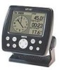
Owner's Manual
Page 9
... List vi Table of Contents viii "How To" Index viii Section One: Getting Started 1-17 Keypad Usage 1 Selecting Options 2 Entering Data 3 Initializing the Receiver 4 Power On 6 Contrast 6 Backlighting 7 Simulator Mode 7 Description of Main Pages 8 Map Page Cursor 9 Marking Waypoints 10 Going to a Destination 11 Simulated Tour ... 46 Route Review Page and Options 47 Active Route Page 52 Main Menu Page 53 Track Tab 54 Introduction Table of Contents Trip Tab 56 Time Tab 56 Page Tab 56 System Tab 57 Units Tab 58 Communication Tab 60 Alarm Tab 62 Celestial Tab 63 GPS Tab 64...
... List vi Table of Contents viii "How To" Index viii Section One: Getting Started 1-17 Keypad Usage 1 Selecting Options 2 Entering Data 3 Initializing the Receiver 4 Power On 6 Contrast 6 Backlighting 7 Simulator Mode 7 Description of Main Pages 8 Map Page Cursor 9 Marking Waypoints 10 Going to a Destination 11 Simulated Tour ... 46 Route Review Page and Options 47 Active Route Page 52 Main Menu Page 53 Track Tab 54 Introduction Table of Contents Trip Tab 56 Time Tab 56 Page Tab 56 System Tab 57 Units Tab 58 Communication Tab 60 Alarm Tab 62 Celestial Tab 63 GPS Tab 64...
Owner's Manual
Page 19
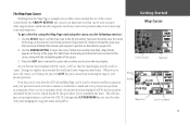
... cursor and re-center your boat to the cursor, along with the cursor, you'll see how the GPS 152's keypad and ENTER/MARK key are used for using the Map Page and using the cursor, try the ...Distance Bearing Map Cursor Cursor Coordinates 9 Notice how another data field, 'Map Pointer', appears at the receiver's last known position (If your boat isn't where it should be near the center of the map, at...keys to set the map scale to other map locations, mark and edit waypoints and routes, and review position data of the page. Your boat should be used to pan to the 50 nm setting....
... cursor and re-center your boat to the cursor, along with the cursor, you'll see how the GPS 152's keypad and ENTER/MARK key are used for using the Map Page and using the cursor, try the ...Distance Bearing Map Cursor Cursor Coordinates 9 Notice how another data field, 'Map Pointer', appears at the receiver's last known position (If your boat isn't where it should be near the center of the map, at...keys to set the map scale to other map locations, mark and edit waypoints and routes, and review position data of the page. Your boat should be used to pan to the 50 nm setting....


