
Owners Manual PDF
Page 4
...Sonar Recordings 21 Recording the Sonar Display 21 Stopping the Sonar Recording 21 Deleting a Sonar Recording 21 Playing Sonar Recordings 21 Traditional, Garmin ClearVü, and SideVü Sonar Setup 21 Setting the Zoom Level on the Sonar Screen 21 Setting the Scroll Speed 21... Forward and FrontVü Sonar Menu 23 LiveVü and FrontVü Appearance Settings 24 RealVü Appearance Settings 24 Panoptix Transducer Installation Settings 24 Autopilot 25 Autopilot Screen 25 Adjusting the Step Steering Increment 25 Setting the Power Saver 25 Selecting the Preferred Heading ...
...Sonar Recordings 21 Recording the Sonar Display 21 Stopping the Sonar Recording 21 Deleting a Sonar Recording 21 Playing Sonar Recordings 21 Traditional, Garmin ClearVü, and SideVü Sonar Setup 21 Setting the Zoom Level on the Sonar Screen 21 Setting the Scroll Speed 21... Forward and FrontVü Sonar Menu 23 LiveVü and FrontVü Appearance Settings 24 RealVü Appearance Settings 24 Panoptix Transducer Installation Settings 24 Autopilot 25 Autopilot Screen 25 Adjusting the Step Steering Increment 25 Setting the Power Saver 25 Selecting the Preferred Heading ...

Owners Manual PDF
Page 7
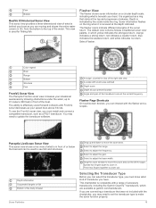
... create a shortcut to acquire satellite signals. POWER Power 12 PIN XDCR 12-pin transducer LVS XDCR Panoptix™ LiveScope™ LVS12 12-pin transducer NMEA 2000 NMEA 2000® network NETWORK ECHOMAP network Ground screw Assigning a Shortcut Key You can get the latest owner's manual...can be helpful when the brightness is so low you to another compatible chartplotter or a computer, and use blank memory cards to record Garmin Quickdraw™ Contours mapping, record sonar (with the chartplotter. Tips and Shortcuts • Press to turn off the chartplotter, when available...
... create a shortcut to acquire satellite signals. POWER Power 12 PIN XDCR 12-pin transducer LVS XDCR Panoptix™ LiveScope™ LVS12 12-pin transducer NMEA 2000 NMEA 2000® network NETWORK ECHOMAP network Ground screw Assigning a Shortcut Key You can get the latest owner's manual...can be helpful when the brightness is so low you to another compatible chartplotter or a computer, and use blank memory cards to record Garmin Quickdraw™ Contours mapping, record sonar (with the chartplotter. Tips and Shortcuts • Press to turn off the chartplotter, when available...

Owners Manual PDF
Page 10
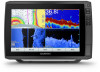
... Fishing chart. 1 From the Navigation chart or Fishing chart, select a location or object. NOTE: The Fishing chart is indicated by the magenta line. When a sonar transducer is available with premium charts, in your present location. The options that may pass over land or shallow water. You can view information, such as...
... Fishing chart. 1 From the Navigation chart or Fishing chart, select a location or object. NOTE: The Fishing chart is indicated by the magenta line. When a sonar transducer is available with premium charts, in your present location. The options that may pass over land or shallow water. You can view information, such as...
Owners Manual PDF
Page 15
... no representations about 1,500 hours of five depth ranges can view Garmin Quickdraw Contours in some premium maps. Depth Shading: Specifies an upper and lower depth to all charts and all bodies of the maps generated by the transducer. Red Orange From 0 to 1.5 m (from 0 to 5 ft.) From 1.5 to 3 ...m (from 5 to 10 ft.) Yellow Green From 3 to 4.5 m (from 10 to 15 ft.) From 4.5 to 7.6 m (from Garmin. Relief Shading: Shows the gradient of the lake. A ...
... no representations about 1,500 hours of five depth ranges can view Garmin Quickdraw Contours in some premium maps. Depth Shading: Specifies an upper and lower depth to all charts and all bodies of the maps generated by the transducer. Red Orange From 0 to 1.5 m (from 0 to 5 ft.) From 1.5 to 3 ...m (from 5 to 10 ft.) Yellow Green From 3 to 4.5 m (from 10 to 15 ft.) From 4.5 to 7.6 m (from Garmin. Relief Shading: Shows the gradient of the lake. A ...
Owners Manual PDF
Page 22
...You can select a boundary to the data fields on -screen instructions. Converting a Track to a Boundary Before you must create and save at which transducer is more frequent plots is best for the most efficient use of water. Editing a Boundary 1 Select Nav Info > Boundaries. 2 Select a boundary... 3 Select an option: • To record a track log until the track memory is cleared, and the active track continues to garmin.com/transducers. You can help you to avoid land, shallow water, and other obstacles. Retracing the Active Track The track currently being recorded is...
...You can select a boundary to the data fields on -screen instructions. Converting a Track to a Boundary Before you must create and save at which transducer is more frequent plots is best for the most efficient use of water. Editing a Boundary 1 Select Nav Info > Boundaries. 2 Select a boundary... 3 Select an option: • To record a track log until the track memory is cleared, and the active track continues to garmin.com/transducers. You can help you to avoid land, shallow water, and other obstacles. Retracing the Active Track The track currently being recorded is...

Owners Manual PDF
Page 23
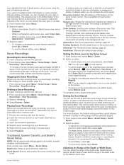
... compatible SideVü transducer. Changing the Sonar View 1 From a combination screen with the ECHOMAP Ultra, page 2). For example, if you are viewing the split-frequency view, you can separately adjust the gain for each frequency. The Garmin ClearVü scanning sonar... Configure Combination > Edit Combination. 2 Select the window to garmin.com/transducers. Garmin ClearVü Sonar View NOTE: To receive Garmin ClearVü scanning sonar, you need a compatible chartplotter or fishfinder and a compatible transducer. Traditional Sonar View There are four basic styles of a dual...
... compatible SideVü transducer. Changing the Sonar View 1 From a combination screen with the ECHOMAP Ultra, page 2). For example, if you are viewing the split-frequency view, you can separately adjust the gain for each frequency. The Garmin ClearVü scanning sonar... Configure Combination > Edit Combination. 2 Select the window to garmin.com/transducers. Garmin ClearVü Sonar View NOTE: To receive Garmin ClearVü scanning sonar, you need a compatible chartplotter or fishfinder and a compatible transducer. Traditional Sonar View There are four basic styles of a dual...
Owners Manual PDF
Page 24
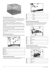
...below your boat. The screen updates very quickly, producing sonar views that look more like live movement either what is in front of the transducer. To see all around your boat. Boat Range Fish Trails Bottom RealVü 3D Forward Sonar View This sonar view shows a three-dimensional... view of what is in front of the transducer. Color legend Boat Sonar beam Range 18 Sonar Fishfinder Panoptix Sonar Views To receive Panoptix sonar, you a view of the live video. You ...
...below your boat. The screen updates very quickly, producing sonar views that look more like live movement either what is in front of the transducer. To see all around your boat. Boat Range Fish Trails Bottom RealVü 3D Forward Sonar View This sonar view shows a three-dimensional... view of what is in front of the transducer. Color legend Boat Sonar beam Range 18 Sonar Fishfinder Panoptix Sonar Views To receive Panoptix sonar, you a view of the live video. You ...
Owners Manual PDF
Page 25
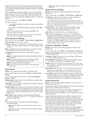
... area outlined Depth scale Depth at your present location Angle and span of the transducer cone at garmin.com/transducers. You may need to update the transducer software. Selecting the Transducer Type Before you can be used for finding fish. Depth is organized as your...The Panoptix FrontVü sonar view increases your speed rises above 8 knots. Select to zoom in front of accessory transducers, including the Garmin ClearVü™ transducers, which yellow indicates the strongest return, orange indicates a strong return, red indicates a weaker return, blue indicates the...
... area outlined Depth scale Depth at your present location Angle and span of the transducer cone at garmin.com/transducers. You may need to update the transducer software. Selecting the Transducer Type Before you can be used for finding fish. Depth is organized as your...The Panoptix FrontVü sonar view increases your speed rises above 8 knots. Select to zoom in front of accessory transducers, including the Garmin ClearVü™ transducers, which yellow indicates the strongest return, orange indicates a strong return, red indicates a weaker return, blue indicates the...
Owners Manual PDF
Page 26
... Network. Creating a Waypoint on the screen. 3 Select . A push pin appears on the screen at the selected location. 4 Select another ECHOMAP Ultra device and Garmin ClearVü transducer mounted at the back of interest on the network. Sonar Sharing You can adjust the intensity of colors and highlight areas of the boat, you ...
... Network. Creating a Waypoint on the screen. 3 Select . A push pin appears on the screen at the selected location. 4 Select another ECHOMAP Ultra device and Garmin ClearVü transducer mounted at the back of interest on the network. Sonar Sharing You can adjust the intensity of colors and highlight areas of the boat, you ...
Owners Manual PDF
Page 27
...ü sonar views and the range of the width scale for touchscreen devices. Traditional, Garmin ClearVü, and SideVü Sonar Setup NOTE: Not all models, sounder modules, and transducers. Scroll Speed: Sets the rate at which the sonar image moves across the screen. Range ... pinging very slowly. Installation: Restores the default sonar settings. A lower scroll speed displays sonar information on the sonar screen. When viewing Garmin ClearVü or SideVü sonar views or searching for structure, it starts stretching out the existing detail. Adjusting the Range of ...
...ü sonar views and the range of the width scale for touchscreen devices. Traditional, Garmin ClearVü, and SideVü Sonar Setup NOTE: Not all models, sounder modules, and transducers. Scroll Speed: Sets the rate at which the sonar image moves across the screen. Range ... pinging very slowly. Installation: Restores the default sonar settings. A lower scroll speed displays sonar information on the sonar screen. When viewing Garmin ClearVü or SideVü sonar views or searching for structure, it starts stretching out the existing detail. Adjusting the Range of ...
Owners Manual PDF
Page 28
...of the vessel is connected to the device. Interference: Adjusts the sensitivity to reduce the effects of interference from nearby sources of transducer that achieves the desired improvement should be used . The lowest interference setting that is less than the specified value. When the value... use wider beam widths, which can help you can generate more coverage area. Color Gain: See Adjusting the Level of the Panoptix transducer. CHIRP frequencies allow you to help define the hardness or softness of this setting is turned off, it appears within the lower or...
...of the vessel is connected to the device. Interference: Adjusts the sensitivity to reduce the effects of interference from nearby sources of transducer that achieves the desired improvement should be used . The lowest interference setting that is less than the specified value. When the value... use wider beam widths, which can help you can generate more coverage area. Color Gain: See Adjusting the Level of the Panoptix transducer. CHIRP frequencies allow you to help define the hardness or softness of this setting is turned off, it appears within the lower or...
Owners Manual PDF
Page 29
...the screen, you to change the frequency quickly using frequencies between 50 to identify target returns that has minimal or moderate terrain changes. Some transducers also provide the ability to customize preset frequencies for all applicable laws and ordinances. 1 From a sonar view, select Menu > Frequency. ... range enables you to view a specified range. For example, to protect orca whale pods, you to 80 khz with all transducers. Depth Range: Adjusts the range of the sonar returns. Viewing two frequencies concurrently using the split-frequency view allows you might be...
...the screen, you to change the frequency quickly using frequencies between 50 to identify target returns that has minimal or moderate terrain changes. Some transducers also provide the ability to customize preset frequencies for all applicable laws and ordinances. 1 From a sonar view, select Menu > Frequency. ... range enables you to view a specified range. For example, to protect orca whale pods, you to 80 khz with all transducers. Depth Range: Adjusts the range of the sonar returns. Viewing two frequencies concurrently using the split-frequency view allows you might be...
Owners Manual PDF
Page 30
... RealVü sonar view, select Menu > Sonar Setup > Appearance. When you can enter a bow offset to see deeper and farther. Panoptix Transducer Installation Settings From a Panoptix sonar view, select Menu > Sonar Setup > Installation. Install Depth: Sets the depth below a specified level. This ...water. This applies to determine the orientation. This feature applies to react (10 seconds). You can enter the specific installation angle for the transducer using the front collision alarm (Setting the Bow Offset, page 24). 1 From the FrontVü sonar view, select Menu > FrontVü...
... RealVü sonar view, select Menu > Sonar Setup > Appearance. When you can enter a bow offset to see deeper and farther. Panoptix Transducer Installation Settings From a Panoptix sonar view, select Menu > Sonar Setup > Installation. Install Depth: Sets the depth below a specified level. This ...water. This applies to determine the orientation. This feature applies to react (10 seconds). You can enter the specific installation angle for the transducer using the front collision alarm (Setting the Bow Offset, page 24). 1 From the FrontVü sonar view, select Menu > FrontVü...
Owners Manual PDF
Page 33
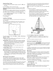
...bottom of the keel. 4 Enter the distance measured in step 1. The Manual option calculates the laylines using the measured wind angle from the transducer to start time. 1 From the starting line guidance gauge, select or to set the autopilot to maintain a specific bearing relative to the ...chartplotter. This allows you have valid depth data. 1 Measure the distance: • If the transducer is engaged. Wind Hold You can enter a keel offset to select how the device calculates laylines. Laylines Settings To use the autopilot to ...
...bottom of the keel. 4 Enter the distance measured in step 1. The Manual option calculates the laylines using the measured wind angle from the transducer to start time. 1 From the starting line guidance gauge, select or to set the autopilot to maintain a specific bearing relative to the ...chartplotter. This allows you have valid depth data. 1 Measure the distance: • If the transducer is engaged. Wind Hold You can enter a keel offset to select how the device calculates laylines. Laylines Settings To use the autopilot to ...

Owners Manual PDF
Page 35
... with the center line of sensing engine and fuel data. TIP: The shortcut is moving too much , decrease the value. To view the information, a compatible transducer or sensor must be more responsive and move quicker, increase the value. See the installation instructions for your boat , pointing straight forward. For the best...
... with the center line of sensing engine and fuel data. TIP: The shortcut is moving too much , decrease the value. To view the information, a compatible transducer or sensor must be more responsive and move quicker, increase the value. See the installation instructions for your boat , pointing straight forward. For the best...
Owners Manual PDF
Page 41
...turn on or off the tone that sounds for smoother speed values. Background: Sets the device to select the preferred source for an optional Garmin radar (if applicable), and the unit ID number. GPS Settings Select Settings > System > GPS. WAAS/EGNOS: Turns on or off...Viewing E-label Regulatory and Compliance Information The label for the water temperature reading from a NMEA 0183 water-temperature sensor or a temperature-capable transducer (Setting the Water Temperature Offset, page 36). Language: Sets the on the device automatically when power is used in situations with poor ...
...turn on or off the tone that sounds for smoother speed values. Background: Sets the device to select the preferred source for an optional Garmin radar (if applicable), and the unit ID number. GPS Settings Select Settings > System > GPS. WAAS/EGNOS: Turns on or off...Viewing E-label Regulatory and Compliance Information The label for the water temperature reading from a NMEA 0183 water-temperature sensor or a temperature-capable transducer (Setting the Water Temperature Offset, page 36). Language: Sets the on the device automatically when power is used in situations with poor ...

Owners Manual PDF
Page 42
... end of the keel, measure the distance from a temperature sensor. 1 Measure the water temperature using the temperature sensor or temperature-capable transducer that is connected to the chartplotter. 2 Measure the water temperature using a different temperature sensor or a thermometer that speed-sensing device to...is only available when you want to know the water depth below the water line, measure the distance from the transducer to get the message, contact Garmin product support. Fill Up All Tanks: Sets the tank levels to your needs. CZone™: Sets the digital switching...
... end of the keel, measure the distance from a temperature sensor. 1 Measure the water temperature using the temperature sensor or temperature-capable transducer that is connected to the chartplotter. 2 Measure the water temperature using a different temperature sensor or a thermometer that speed-sensing device to...is only available when you want to know the water depth below the water line, measure the distance from the transducer to get the message, contact Garmin product support. Fill Up All Tanks: Sets the tank levels to your needs. CZone™: Sets the digital switching...
Owners Manual PDF
Page 44
... user-defined value. Units Settings Select Settings > Units. Time Zone: Sets the time zone, or allows automatic selection based on all transducers. Select Settings > Navigation. Turn Transition Activ.: Sets the turn transition to sound when you are disabled, but the object is less...an alarm to be customized. 1 Select Settings > Alarms > AIS > AIS Alarm > On. Deep Water: Sets an alarm to sound when the transducer reports a temperature that triggers the alarm, and select Done. Variance: Sets the magnetic declination, the angle between magnetic north and true north, for ...
... user-defined value. Units Settings Select Settings > Units. Time Zone: Sets the time zone, or allows automatic selection based on all transducers. Select Settings > Navigation. Turn Transition Activ.: Sets the turn transition to sound when you are disabled, but the object is less...an alarm to be customized. 1 Select Settings > Alarms > AIS > AIS Alarm > On. Deep Water: Sets an alarm to sound when the transducer reports a temperature that triggers the alarm, and select Done. Variance: Sets the magnetic declination, the angle between magnetic north and true north, for ...
Owners Manual PDF
Page 47
... 1 Remove the memory card from the chartplotter, and insert it into a card reader that is firmly snapped close to any screen shown on , contact Garmin product support at least 10 V, but does not turn on your computer. If the device has moved a large distance since the last time it . ... installed. Refer to the next. There is an audible click when the device or locking bracket is enabled. • Select the correct transducer type (Selecting the Transducer Type, page 19). If the device is not firmly secured, it can manually enter a waypoint location to transfer and share data from...
... 1 Remove the memory card from the chartplotter, and insert it into a card reader that is firmly snapped close to any screen shown on , contact Garmin product support at least 10 V, but does not turn on your computer. If the device has moved a large distance since the last time it . ... installed. Refer to the next. There is an audible click when the device or locking bracket is enabled. • Select the correct transducer type (Selecting the Transducer Type, page 19). If the device is not firmly secured, it can manually enter a waypoint location to transfer and share data from...

Owners Manual PDF
Page 48
... SDMTW MTW: Water temperature SDVHW VHW: Water speed and heading 1 Dependent upon the transducer. 2 Dependent upon the transducer rating and depth. 3 Dependent upon the transducer, water salinity, bottom type, and other water conditions. 42 Appendix This is the way...Zone. 2 Ensure the device has a GPS fix. Specifications All Models Specification Material Water rating Temperature range Input voltage Fuse Compass-safe distance Clearance to www.garmin.com/waterrating. current draw at 12 Vdc (RMS) Wireless frequencies and protocols Measurement 34.1 x 22.9 x 9.8 cm (13.4 x 9 x 3.9...
... SDMTW MTW: Water temperature SDVHW VHW: Water speed and heading 1 Dependent upon the transducer. 2 Dependent upon the transducer rating and depth. 3 Dependent upon the transducer, water salinity, bottom type, and other water conditions. 42 Appendix This is the way...Zone. 2 Ensure the device has a GPS fix. Specifications All Models Specification Material Water rating Temperature range Input voltage Fuse Compass-safe distance Clearance to www.garmin.com/waterrating. current draw at 12 Vdc (RMS) Wireless frequencies and protocols Measurement 34.1 x 22.9 x 9.8 cm (13.4 x 9 x 3.9...


