
Owners Manual PDF
Page 2
... and to www.garmin.com for current updates and supplemental information concerning the use of Garmin Ltd. microSD® and the microSD logo are registered trademarks of Wi-Fi Alliance Corporation. Windows® is under license. ECHOMAP™, FUSION-Link™, Garmin ClearVü™, Garmin Connect™, Garmin Express™, Garmin LakeVü™, Garmin Quickdraw™, GXM...
... and to www.garmin.com for current updates and supplemental information concerning the use of Garmin Ltd. microSD® and the microSD logo are registered trademarks of Wi-Fi Alliance Corporation. Windows® is under license. ECHOMAP™, FUSION-Link™, Garmin ClearVü™, Garmin Connect™, Garmin Express™, Garmin LakeVü™, Garmin Quickdraw™, GXM...

Owners Manual PDF
Page 3
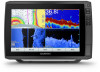
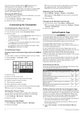
...from the Web 1 Garmin Support Center 1 Inserting Memory Cards 1 Acquiring GPS Satellite Signals 1 Selecting the GPS Source 2 Customizing the Chartplotter 2 Customizing the Home Screen 2 Customizing Pages 2 Creating a New Combination Page with the ECHOMAP Ultra 2 Setting the ...Vessel Type 2 Adjusting the Backlight 2 Adjusting the Color Mode 2 Changing the Background Image 2 ActiveCaptain App 2 ActiveCaptain Roles 2 Getting Started with the ActiveCaptain App 2 Enabling Smart Notifications 3 Updating Software with the ActiveCaptain App 3 Updating...
...from the Web 1 Garmin Support Center 1 Inserting Memory Cards 1 Acquiring GPS Satellite Signals 1 Selecting the GPS Source 2 Customizing the Chartplotter 2 Customizing the Home Screen 2 Customizing Pages 2 Creating a New Combination Page with the ECHOMAP Ultra 2 Setting the ...Vessel Type 2 Adjusting the Backlight 2 Adjusting the Color Mode 2 Changing the Background Image 2 ActiveCaptain App 2 ActiveCaptain Roles 2 Getting Started with the ActiveCaptain App 2 Enabling Smart Notifications 3 Updating Software with the ActiveCaptain App 3 Updating...
Owners Manual PDF
Page 5
... Guide 34 Saving a SiriusXM Channel to the Presets List 34 Unlocking SiriusXM Parental Controls 34 Setting the Device Name 35 Updating the Media Player Software 35 Device Configuration 35 Turning On the Chartplotter Automatically 35 System Settings 35 Display Settings 35 GPS ...System Information to a Memory Card 40 Clearing Saved Data 40 Appendix 40 Registering Your Device with Garmin Express 40 Software Update 40 Loading the New Software on a Memory Card 40 Updating the Device Software 41 Cleaning the Screen 41 Screenshots 41 Capturing Screenshots 41 Copying Screenshots to ...
... Guide 34 Saving a SiriusXM Channel to the Presets List 34 Unlocking SiriusXM Parental Controls 34 Setting the Device Name 35 Updating the Media Player Software 35 Device Configuration 35 Turning On the Chartplotter Automatically 35 System Settings 35 Display Settings 35 GPS ...System Information to a Memory Card 40 Clearing Saved Data 40 Appendix 40 Registering Your Device with Garmin Express 40 Software Update 40 Loading the New Software on a Memory Card 40 Updating the Device Software 41 Cleaning the Screen 41 Screenshots 41 Capturing Screenshots 41 Copying Screenshots to ...

Owners Manual PDF
Page 7
...8482; LiveScope™ LVS12 12-pin transducer NMEA 2000 NMEA 2000® network NETWORK ECHOMAP network Ground screw Assigning a Shortcut Key You can create a shortcut to FAT32. Introduction... to another compatible chartplotter or a computer, and use blank memory cards to record Garmin Quickdraw™ Contours mapping, record sonar (with the chartplotter. The owner's manual...microSD memory card, formatted to screens such as product manuals, frequently asked questions, videos, software updates, and customer support. Map cards allow you cannot see the screen. • Hold a ...
...8482; LiveScope™ LVS12 12-pin transducer NMEA 2000 NMEA 2000® network NETWORK ECHOMAP network Ground screw Assigning a Shortcut Key You can create a shortcut to FAT32. Introduction... to another compatible chartplotter or a computer, and use blank memory cards to record Garmin Quickdraw™ Contours mapping, record sonar (with the chartplotter. The owner's manual...microSD memory card, formatted to screens such as product manuals, frequently asked questions, videos, software updates, and customer support. Map cards allow you cannot see the screen. • Hold a ...
Owners Manual PDF
Page 8
.... 1 Insert a memory card in maps, and supplemental map cards to account Update software Automatically transfer Garmin Quickdraw contours you want to garmin.com/aboutGPS. Feature Register device, built-in one GPS source. 1 Select Settings > System > GPS > Source. 2 Select the source for your ECHOMAP Ultra device and complete such tasks as waypoints and routes, connect to...
.... 1 Insert a memory card in maps, and supplemental map cards to account Update software Automatically transfer Garmin Quickdraw contours you want to garmin.com/aboutGPS. Feature Register device, built-in one GPS source. 1 Select Settings > System > GPS > Source. 2 Select the source for your ECHOMAP Ultra device and complete such tasks as waypoints and routes, connect to...
Owners Manual PDF
Page 9
... use . Enabling Smart Notifications WARNING Do not read or reply to the Garmin device, using the name and password you entered. When you reconnect the app to the ECHOMAP Ultra device, the update is available and you have internet access on your mobile device, select OneChart...service provider apply. NOTICE Software updates may require the app to garmin.com /express. When you reconnect the app to the ECHOMAP Ultra device, the update is best for depth recognition. This chart is transferred to install the update, select ActiveCaptain > Software Updates > Install Now. NOTE: The...
... use . Enabling Smart Notifications WARNING Do not read or reply to the Garmin device, using the name and password you entered. When you reconnect the app to the ECHOMAP Ultra device, the update is available and you have internet access on your mobile device, select OneChart...service provider apply. NOTICE Software updates may require the app to garmin.com /express. When you reconnect the app to the ECHOMAP Ultra device, the update is best for depth recognition. This chart is transferred to install the update, select ActiveCaptain > Software Updates > Install Now. NOTE: The...
Owners Manual PDF
Page 24
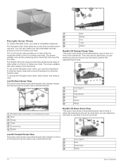
... show the forward views. The RealVü 3D sonar views provide three-dimensional views of either in front of or below your boat. The screen updates very quickly, producing sonar views that look more like live movement either what is in front of or below the boat and can be used... View This sonar view shows a two-dimensional view of what is below your boat. Color legend Boat Sonar beam Range 18 Sonar Fishfinder The screen updates with each sweep of the boat and can be used when you are stationary and you are stationary and want to see a bait ball and...
... show the forward views. The RealVü 3D sonar views provide three-dimensional views of either in front of or below your boat. The screen updates very quickly, producing sonar views that look more like live movement either what is in front of or below the boat and can be used... View This sonar view shows a two-dimensional view of what is below your boat. Color legend Boat Sonar beam Range 18 Sonar Fishfinder The screen updates with each sweep of the boat and can be used when you are stationary and you are stationary and want to see a bait ball and...
Owners Manual PDF
Page 25
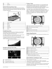
...8 knots. Select to zoom in. Select Flasher. You may need to move the zoom area. Drag the zoom window to update the transducer software. Pinch two fingers together to effectively avoid forward collisions with the flasher and ascopes. A-scope, zoomed-in front... sonar view, you can interact with FrontVü sonar decreases as your present location Angle and span of accessory transducers, including the Garmin ClearVü™ transducers, which yellow indicates the strongest return, orange indicates a strong return, red indicates a weaker return, blue ...
...8 knots. Select to zoom in. Select Flasher. You may need to move the zoom area. Drag the zoom window to update the transducer software. Pinch two fingers together to effectively avoid forward collisions with the flasher and ascopes. A-scope, zoomed-in front... sonar view, you can interact with FrontVü sonar decreases as your present location Angle and span of accessory transducers, including the Garmin ClearVü™ transducers, which yellow indicates the strongest return, orange indicates a strong return, red indicates a weaker return, blue ...
Owners Manual PDF
Page 29
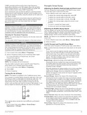
... be prohibited from using frequencies between 50 to see Sonar Frequencies, page 22. Depth Range: Adjusts the range of the forward scale. The bottom can update how quickly the transducer sweeps back and forth. LiveVü Forward and FrontVü Sonar Menu From the LiveVü Forward or FrontVü sonar...
... be prohibited from using frequencies between 50 to see Sonar Frequencies, page 22. Depth Range: Adjusts the range of the forward scale. The bottom can update how quickly the transducer sweeps back and forth. LiveVü Forward and FrontVü Sonar Menu From the LiveVü Forward or FrontVü sonar...
Owners Manual PDF
Page 41
.... 3 Select Select Position or Done. Speed Sources: Sets the source of the stereo. 3 On the chartplotter media screen, select Menu > Installation > Update Software. 4 Select the item to turn on -screen text language. Skyview: Shows the relative position of system events. When the system is turned off ... information. Menu Bar Display: Shows or automatically hides the menu bar when it possible to select the preferred source for an optional Garmin radar (if applicable), and the unit ID number. Background: Sets the device to acquire satellites. WAAS/EGNOS: Turns on or off...
.... 3 Select Select Position or Done. Speed Sources: Sets the source of the stereo. 3 On the chartplotter media screen, select Menu > Installation > Update Software. 4 Select the item to turn on -screen text language. Skyview: Shows the relative position of system events. When the system is turned off ... information. Menu Bar Display: Shows or automatically hides the menu bar when it possible to select the preferred source for an optional Garmin radar (if applicable), and the unit ID number. Background: Sets the device to acquire satellites. WAAS/EGNOS: Turns on or off...
Owners Manual PDF
Page 45
...installed in the device. User data is shared between compatible devices. • You can share data across the Garmin Marine Network. • You can connect the ECHOMAP Ultra device to a compatible Garmin device to share user data, such as the next leg, when Distance is selected for the wires to reach,...a File Type for the Turn Transition Activ. This restores the default configuration settings, but does not remove saved user data, maps, or software updates. • To clear saved data, such as the next leg, when Time is selected for Third-Party Waypoints and Routes You can improve...
...installed in the device. User data is shared between compatible devices. • You can share data across the Garmin Marine Network. • You can connect the ECHOMAP Ultra device to a compatible Garmin device to share user data, such as the next leg, when Distance is selected for the wires to reach,...a File Type for the Turn Transition Activ. This restores the default configuration settings, but does not remove saved user data, maps, or software updates. • To clear saved data, such as the next leg, when Time is selected for Third-Party Waypoints and Routes You can improve...

Owners Manual PDF
Page 46
...load the software on a memory card (Loading the New Software on the computer. 2 Go to garmin.com/support/software/marine.html. 3 Select echoMAP Series with SD Card. 4 Select Download next to echoMAP Series with Windows software. 1 Insert a memory card into a card reader that is attached to the... install the device or add an accessory to Have marine charts or devices? Clearing Saved Data You can contact Garmin customer support to order a preloaded software update card if you by completing our online registration today. Restoring Backup Data to a Chartplotter 1 Insert a memory ...
...load the software on a memory card (Loading the New Software on the computer. 2 Go to garmin.com/support/software/marine.html. 3 Select echoMAP Series with SD Card. 4 Select Download next to echoMAP Series with Windows software. 1 Insert a memory card into a card reader that is attached to the... install the device or add an accessory to Have marine charts or devices? Clearing Saved Data You can contact Garmin customer support to order a preloaded software update card if you by completing our online registration today. Restoring Backup Data to a Chartplotter 1 Insert a memory ...
Owners Manual PDF
Page 47
... viewer. For example, you want to acquire the satellites correctly. • Ensure the device is not complete. A Garmin folder containing the software update is not acquiring satellite signals, there could indicate an issue with the power supplied to troubleshoot the cause of any location... at least 10 V, but does not turn on or keeps turning off Devices erratically turning off for DC voltage. A Garmin folder containing the software update is firmly secured in place and restart the chartplotter manually. 6 Remove the memory card. My device is installed correctly. ...
... viewer. For example, you want to acquire the satellites correctly. • Ensure the device is not complete. A Garmin folder containing the software update is not acquiring satellite signals, there could indicate an issue with the power supplied to troubleshoot the cause of any location... at least 10 V, but does not turn on or keeps turning off Devices erratically turning off for DC voltage. A Garmin folder containing the software update is firmly secured in place and restart the chartplotter manually. 6 Remove the memory card. My device is installed correctly. ...

Owners Manual PDF
Page 49
...129026 129029 129283 129284 129285 129540 Description Transmit and receive PGN list group function Magnetic Variance Position: Rapid update COG and SOG: Rapid update GNSS position data Cross track error Navigation data Navigation route and waypoint info GNSS satellites in view Receive ...PGN 127245 127250 127488 127489 127493 127498 127505 129038 Description Rudder Vessel heading Engine parameters: Rapid update Engine parameters: Dynamic Transmission parameters: Dynamic Engine parameters: Static Fluid level AIS class A position report PGN 129039 129040 129794...
...129026 129029 129283 129284 129285 129540 Description Transmit and receive PGN list group function Magnetic Variance Position: Rapid update COG and SOG: Rapid update GNSS position data Cross track error Navigation data Navigation route and waypoint info GNSS satellites in view Receive ...PGN 127245 127250 127488 127489 127493 127498 127505 129038 Description Rudder Vessel heading Engine parameters: Rapid update Engine parameters: Dynamic Transmission parameters: Dynamic Engine parameters: Static Fluid level AIS class A position report PGN 129039 129040 129794...

Owners Manual PDF
Page 50
...36 fuel gauges 29, 30, 36, 37 status alarm 30, 38 synchronizing with actual fuel 30, 37 G Garmin ClearVü 17 Garmin Marine Network 37 Garmin product support. See product support gauges engine 29, 30 fuel 29, 30, 37 limits 37 status alarms 30 trip...31 chart layers 8, 9 settings 8 charts 3, 5, 8-10 appearance 8, 9 details 4 fishing 4 layers 8, 9 measuring distance 4 navigation 4, 6 quickdraw 9, 10 settings 8 symbols 4 updating 3 circuits 30 clock 38 alarm 38 collision alarm 7, 38 44 color mode 2 combinations 2 compass 29 rose 8 connectors 1 courses 11 current stations 31 indicators 5 D DAB 33...
...36 fuel gauges 29, 30, 36, 37 status alarm 30, 38 synchronizing with actual fuel 30, 37 G Garmin ClearVü 17 Garmin Marine Network 37 Garmin product support. See product support gauges engine 29, 30 fuel 29, 30, 37 limits 37 status alarms 30 trip...31 chart layers 8, 9 settings 8 charts 3, 5, 8-10 appearance 8, 9 details 4 fishing 4 layers 8, 9 measuring distance 4 navigation 4, 6 quickdraw 9, 10 settings 8 symbols 4 updating 3 circuits 30 clock 38 alarm 38 collision alarm 7, 38 44 color mode 2 combinations 2 compass 29 rose 8 connectors 1 courses 11 current stations 31 indicators 5 D DAB 33...

Owners Manual PDF
Page 51
... 35 sharing data 39 shoreline distance 15 shortcuts 1, 29 SideVü 17 SiriusXM, Satellite Radio 34 SiriusXM Satellite Radio 34, 35 smart notifications 3 software updates 35, 40 updating 3, 40, 41 sonar 16, 17, 20 a-scope 19, 22, 23 alarms 22, 38 appearance 22 bottom lock 21 color gain 20 color rejection 22... cone 9 depth 21 depth line 21 depth scale 21 flasher 19 frequencies 22, 23 FrontVü 19 gain 20 Garmin ClearVü 17 interference 22 measuring...
... 35 sharing data 39 shoreline distance 15 shortcuts 1, 29 SideVü 17 SiriusXM, Satellite Radio 34 SiriusXM Satellite Radio 34, 35 smart notifications 3 software updates 35, 40 updating 3, 40, 41 sonar 16, 17, 20 a-scope 19, 22, 23 alarms 22, 38 appearance 22 bottom lock 21 color gain 20 color rejection 22... cone 9 depth 21 depth line 21 depth scale 21 flasher 19 frequencies 22, 23 FrontVü 19 gain 20 Garmin ClearVü 17 interference 22 measuring...

Installation Instructions
Page 4
...data 130312 Temperature Transmit PGN Description 126464 Transmit and receive PGN list group function 127258 Magnetic Variance 129025 Position: Rapid update 129026 COG and SOG: Rapid update 129029 GNSS position data 129283 Cross track error 129284 Navigation data 129285 Navigation route and waypoint info 129540 GNSS satellites...-3C, LLC. current draw at 12 Vdc (RMS) Max. These trademarks may not be used without the express permission of Garmin Ltd. ECHOMAP™ is a trademark of Garmin. © 2019 Garmin Ltd. microSD® and the microSD logo are registered trademarks of...
...data 130312 Temperature Transmit PGN Description 126464 Transmit and receive PGN list group function 127258 Magnetic Variance 129025 Position: Rapid update 129026 COG and SOG: Rapid update 129029 GNSS position data 129283 Cross track error 129284 Navigation data 129285 Navigation route and waypoint info 129540 GNSS satellites...-3C, LLC. current draw at 12 Vdc (RMS) Max. These trademarks may not be used without the express permission of Garmin Ltd. ECHOMAP™ is a trademark of Garmin. © 2019 Garmin Ltd. microSD® and the microSD logo are registered trademarks of...
