Garmin echoMAP 70s Support Question
Garmin echoMAP 70s Support Question
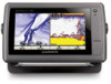
Find answers below for this question about Garmin echoMAP 70s.Need a Garmin echoMAP 70s manual? We have 10 online manuals for this item!
Question posted by ochoreale on February 11th, 2014
External Gps Input
how to connect external gps for echoMAP 70s
Current Answers
Related Garmin echoMAP 70s Manual Pages
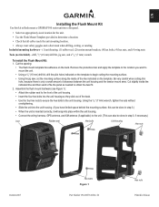
Flush Mount Kit Instructions (multilingual) - Page 1
...; Attach the rubber seal to the front of the unit housing.
• Insert the four hex bolts into place within the unit housing.
• Connect the wiring harness, GPS antenna, and XM antenna (if applicable) to the unit. (This can also be done in Taiwan Using the 9/32" (7 mm) wrench, tighten the...
Flush Mount Kit Instructions (multilingual) - Page 2
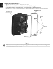
... mount hardware
Tension mount brackets
Wing nuts
Figure 2
NOTE: You must connect the wiring harness to the unit, then slide the unit into the unit... Figure 2): • Place the unit housing in the recently cut hole in step 2, connect the wiring harness to the boat's power supply, GPS antenna, XM antenna (if applicable), and transducer (if applicable) per the installation instructions included...
Quick Reference Guide - Page 2

...zoom in or out on a chart, to page up or down on the unit, the GPS receiver must collect satellite data and establish the current location. From the Navigation chart, use ... Fish Eye 3D, select MENU > Waypoints & Tracks > Active Tracks > Clear Active Track. Acquiring GPS Satellite Signals When you
want to manually adjust the backlight. Select Backlight. 3.
Using Routes and Tracks
...
Important Safety and Product Information - Page 2
... in 1 meter of Directive 1999/5/EC. Official government charts and notices to mariners contain all information needed to navigate safely. • Use this product is ...for various purposes, such as a navigational aid. If your product has video input capability. Declaration of Conformity Hereby, Garmin, declares that may use a combination of... GPS unit may damage plastic components.
Important Safety and Product Information - Page 3
... operation of this period, Garmin will be free from the GPS unit.
• Consult the dealer or an experienced radio...Increase the separation between the equipment and the receiver.
• Connect the equipment into an outlet that are more stringent than "... misuse, water, flood, fire, or other acts of nature or external causes; (iv) damage caused by service performed by an authorized Garmin ...
Chartplotter Configuration Guide for Mercury Zeus and Axius Systems - Page 1
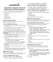
... the mini-USB cable. 3. Select Back. 5. Select Garmin, and set all input and output ports.
Connect the GPSMAP 600 to your chartplotter model and the available software version. After confirming ...Download.
• For the GPSMAP 4000/5000 and 6000/7000 series, in the section called "Garmin Marine Network with SD card", click Download.
4. Repeat steps 2 and 3 for all of the other route...
Installation Instructions - Page 9
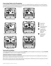
Connecting Cables to the Chartplotter
Use the diagrams below the water line. Testing ...
➊
➌
GPSMAP 530, 535, 540, and 545
➊
➋
➌
➊ Wiring harness ➋ NMEA 2000 ➌ External GPS antenna
(sold separately)
➍ Compatible XM
antenna with audio adapter (sold separately)
➎ Compatible XM
antenna (sold separately)
GPSMAP 521, 541, ...
Owner's Manual - Page 4
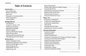
...the Unit On or Off 2 Initializing Unit Settings 2 Adjusting the Backlight 3 Using the Keypad 4 Acquiring GPS Satellite Signals 5 Using Simulator Mode 5 Inserting and Removing SD Cards 5 Understanding the Home Screen 6
... Chart Settings 11 Using the Split Navigation Chart 14 Using Perspective 3D 14 Using Mariner's Eye 3D 15 Using Fish Eye 3D 17
ii
Using Fishing Charts 17 Enabling...
Owner's Manual - Page 7
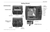
Unit Overview
GPSMAP 526/556
Getting Started
NMEA 2000®
Power/Data
External GPS antenna
GPSMAP 421/451/ 521/551
Power/Data
NMEA 2000
GPSMAP 400/500 Series Owner's Manual
External GPS antenna
Getting Started
POWER/ BACKLIGHT RANGE (-/+) ROCKER MARK SELECT MENU HOME
SD card slot GPSMAP 526 shown
1
Owner's Manual - Page 36
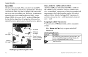
...get the most out of your unit. The BlueChart g2 Vision Mariner's Eye 3D is more detailed than the preloaded data (page 15...To, Route To, Guide To, or Follow Track), if you are connected to your destination (page 50). Navigating with enhanced bottom contours and ... of the land and water on BlueChart g2 Vision-compatible Garmin GPS units.
GPSMAP 400/500 Series Owner's Manual
Where To? In...
Owner's Manual - Page 48
When connected to ...target
AIS vessel
Dangerous AIS target
Closest point and time of approach to an external AIS device, the chartplotter can show some AIS information about other vessels that are...reported for each vessel includes the Maritime Mobile Service Identity (MMSI), the location, the GPS speed, the GPS heading, the time that has elapsed since the last position of tracking a SART ...
Owner's Manual - Page 51

... view is reported about AIS-activated vessels. • Proj. Select the length of an external AIS device and active transponder signals from your built-in map supports Fishing charts.
1. Fishing...views. Select Navigation Chart, Fishing Chart, Perspective 3D, or
Mariner's Eye 3D. 3. You can view the AIS signal status, MMSI, GPS speed, GPS heading, and other vessels appear on a chart or on a...
Owner's Manual - Page 60
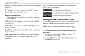
... Home screen, select Configure > Alarms > Fuel >
Total Onboard > On (or Off). 2. GPS Accuracy-set an alarm to sound when the unit detects a suspended target of remaining onboard fuel reaches... only.
-sounds an alarm for large fish only.
Configuring the Chartplotter
Battery-set an alarm to an external fuel sensor, such as the Garmin GFS 10. Setting Sonar Alarms
To set the fuel alarm level: ...
Owner's Manual - Page 75
...Card Needed-Your unit needs to have drifted out of the dangerous target. Accuracy Alarm-the GPS accuracy has fallen outside of the antenna wiring is crimped, broken, or contacting the chassis....moving fast enough for the unit. Battery Voltage Is Too High-too much input voltage-the unit shuts off .
Decrease the input voltage to the maximum voltage allowed (or less) for your dealer or ...
Owner's Manual - Page 80

... battery 54 clock 53 collision 56 deep water 54 engine gauge 33 fish 54 fuel 54 GPS accuracy 54 navigation 53 off course 53 safe-zone 56 shallow water 54 sonar 54 water temp...Sonar screen
using 22 Chart Borders 13 chart data 9 charts
detail 12 fish eye 3D 17 fishing 17
mariner's eye 3D 15 navigation 7 settings 11 Clear User Data 39 collision alarm 56 colors, hazard 16 Color...
Owner's Manual - Page 81
...screen, sonar 57 fuse 68
G
gain 61 Garmin Data Transfer 51 go to 23 GPS 5, 48, 68 GPS heading 37 Grid (North) 49 grid coordinates
creating waypoints using 25 ground wind 36 guide to...13
M
magnetic heading 37 Man Overboard 25, 64 Manual Zoom 61 map datum 49 MapSource data 39 mariner's eye 3D 15
colors 16 mark current location 25 measuring distance 26 MENU key 5 messages 69 move ...
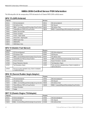
Technical Reference for Garmin NMEA 2000 Products - Page 3

... 4x1/5x1/5x6 Series chartplotters ◦◦ GMI™ 10 ◦◦ GPS 17x ◦◦ GFS™ 10 ◦◦ GRA™ 10 &#...provide Parameter Group Number (PGN) information for Garmin chartplotters and marine instruments as well as configuration and PGN information for Garmin NMEA ... fundamental concepts of connected NMEA 2000 devices that communicate using basic plug-and-play functionality....
Technical Reference for Garmin NMEA 2000 Products - Page 4

...Requirements...9
NMEA 2000-Certified Display Device PGN Information...13
NMEA 2000-Certified Sensor PGN Information...18 GPS 17x (GPS Antenna)...18 GFS 10 (Garmin Fuel Sensor)...18 GRA 10 (Garmin Rudder Angle Adapter)...18 ...Depth Transducer-Transom Mount and Thru-Hull)...19 GWS 10 (Garmin Wind Sensor)...20 GHP 10 (Marine Autopilot System)...20 GXM 51...21 VHF 200...21 VHF 300...21 AIS 300...22 AIS ...
Technical Reference for Garmin NMEA 2000 Products - Page 22
...Adapter)
Transmit
059392
ISO Acknowledgment
060928
ISO Address Claim
126208
NMEA - GPS 17x (GPS Antenna)
Transmit
Receive
059392 060928 126208 126464 126992 126996 129025 129026 129029 ... 127489 127497 127505
127505
Fluid Level (when calibrated using a Garmin chartplotter or marine instrument)
GRA 10 (Garmin Rudder Angle Adapter)
Transmit
Receive
059392
ISO Acknowledgment
059392...
Technical Reference for Garmin NMEA 2000 Products - Page 28

...marine instrument requires a speed sensor, in the fuel tank or tanks.
While viewing the NMEA 2000 device configuration menu, select the GFS 10 device that fuel tank.
Choose from the GFS 10: 1. Select either GPS Speed or Water Speed to specify which speed sensor is connected... a Garmin Chartplotter or Marine Instrument To receive fuel-level information, connect the wiring harness on ...
Similar Questions

Echomap 70s
Your WEB site does not have an owners manual for my Echomap 70S on my 2015 Chaparral boat.Please ema...
Your WEB site does not have an owners manual for my Echomap 70S on my 2015 Chaparral boat.Please ema...
(Posted by Anonymous-166735 3 years ago)

Not Acquiring Satellite Garmin Gps 78
What do i do if my Garmin GPS 78 does not acquire any sattelites?
What do i do if my Garmin GPS 78 does not acquire any sattelites?
(Posted by vitawyler 7 years ago)

How Do I View And Print Saved Tracks On My Computer?
Please help!! I have "Googled" and "Googled" trying to get information on how to view and print save...
Please help!! I have "Googled" and "Googled" trying to get information on how to view and print save...
(Posted by tatwalsh 9 years ago)

Instruction Video For My Gps Map 478 Garmin.
I am looking for an instruction video for my GPS Map 478 Garmin Marine.
I am looking for an instruction video for my GPS Map 478 Garmin Marine.
(Posted by bobkogon 11 years ago)
External Antenna For Unit With Internal Antenna
Can you add an external GPS antenna to the GPSMAP 172C with the internal antenna?
Can you add an external GPS antenna to the GPSMAP 172C with the internal antenna?
(Posted by southcolby 12 years ago)