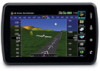
Garmin aera 795 Support Question
Garmin aera 795 Support Question
Find answers below for this question about Garmin aera 795.Need a Garmin aera 795 manual? We have 2 online manuals for this item!
Question posted by vctrs4food on November 24th, 2012
Aera 796 Alt Lags On Dept.
I get obstacle and terrain warnings for several min after departure till the alt readout catches up with the aircraft. Any one else have this problem? I have the most current software.
Current Answers
Related Garmin aera 795 Manual Pages
Pilot's Guide - Page 13
... 129 Aural Alerts...131
Appendix B: Abnormal Operation 133 Loss of GPS Position...133 Hazard Display with Loss of GPS Position 133
Appendix C: SD Cards and Databases 134 SD Card Use...134 Databases...135
Appendix D: Installation and Interfacing 139 Mounting the aera 795/796 in the Aircraft 139 Connecting to a Computer 143
190-01194-00 Rev. A
Garmin...
Pilot's Guide - Page 14
... 40 Antenna (aera 796 146 Connecting to a GTX 330 Mode S Transponder 147 Interfacing...147 Using an external GPS Antenna (Optional ... Track Log...160 Heading Line...163 E6B Calculator...164 Aircraft Profile...166 Weight & Balance...168 Proximity Waypoints...170 ...K: License Agreement and Warranty 187 Contact Garmin...187 Software License Agreement 187 Limited Warranty...187 AOPA Airport Directory...
Pilot's Guide - Page 19
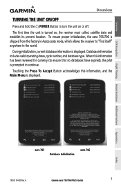
The first time the unit is displayed. During initialization, current database information is turned on or off.
A
Garmin aera 795/796 Pilot's Guide
5
Flight Planning Hazard Avoidance Additional Features
Appendices
Index
aera 795 Database Initialization
aera 796
190-01194-00 Rev. Overview
GPS Navigation
Overview
TURNING THE UNIT ON/OFF
Press and hold the POWER Button to turn the ...
Pilot's Guide - Page 56

... of pointer, name, and other pertinent information)
• Map range
• Aircraft icon (representing present position)
• Flight plan legs
• User waypoints
• Track vector
42
Garmin aera 795/796 Pilot's Guide
190-01194-00 Rev. A
Index VNAV Indicator
GPS Navigation
Additional Features Hazard Avoidance Flight Planning
Appendices
VNAV Indicator (Panel)
2.4 MAP...
Pilot's Guide - Page 73
... information). Appendices
Index
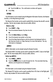
190-01194-00 Rev. The Nearest City function can be used to quickly find a city near the aircraft's current position. The list only includes ARTCC that are displayed. A
Garmin aera 795/796 Pilot's Guide
59 Select a city: 1) Touch NRST > City. 2) Touch the desired Nearest City from the list.
The associated bearing,
distance...
Pilot's Guide - Page 76

...aera 795/796 Pilot's Guide
190-01194-00 Rev.
Airspace Alert Message
Smart Airspace
Smart Airspace shows airspace at all other altitudes are de-emphasized.
A Airspaces at and immediately surrounding the aircraft's current...the 'Smart Airspace' On/Off Button. Overview
GPS Navigation
Additional Features Hazard Avoidance Flight Planning
GPS Navigation Airspace alert setup: 1) From the Main ...
Pilot's Guide - Page 93
...GPS Navigation
Flight Planning Hazard Avoidance Additional Features
Hazard Avoidance
SECTION 4 HAZARD AVOIDANCE
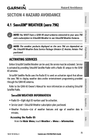
4.1 SiriusXM® WEATHER (aera 796)
NOTE: You MUST have a GXM 40 smart antenna connected to your aera 796...weather data in
minutes.
Appendices
Index
190-01194-00 Rev. A
Garmin aera 795/796 Pilot's Guide
79 ACTIVATING SERVICES
Before SiriusXM Satellite Weather can be activated. ...
Pilot's Guide - Page 110

... is a widely-used to MSL. OBSTACLE INFORMATION
Obstacles are referenced to determine terrain and obstacle proximity. No terrain and obstacle information is derived from satellite position. The aera 795/796 GPS receiver provides the horizontal position and altitude of the surrounding terrain and obstacles relative to determine MSL altitude. Aircraft GPS altitude is shown without a valid...
Pilot's Guide - Page 111

...the top of the obstacle, or Above Ground Level (AGL).
A
Garmin aera 795/796 Pilot's Guide
97
Index Enabling/Disabling Terrain Shading on /off.
Unlighted Obstacle Lighted Obstacle
< 1000'
> 1000'
Potential < 1000' > 1000' Impact Points
Obstacle Location
AGL
AGL
AGL AGL
WARNING: Red obstacle is above or within 100 feet below the aircraft.
b) Touch the Terrain 'Show/Hide' Button...
Pilot's Guide - Page 114

... on the sensitivity level set within the software algorithms, and are simultaneously issued. pull up !"
pull up !" Alert
Terrain
Obstacle
Caution
"caution, terrain" "caution, terrain ahead"
"caution, obstacle" "caution, obstacle
ahead"
Warning
100
"terrain ahead! pull up alert appears.
Hazard Avoidance
Overview
GPS Navigation
Additional Features Hazard Avoidance Flight...
Pilot's Guide - Page 119

...Electronic Checklists
+
+
+
+
+
+
+
+
+
+
+
+
+
+
+
Additional Features
++ ++ ++
++
Appendices
Index
190-01194-00 Rev. A
Garmin aera 795/796 Pilot's Guide
105 The following additional features are included with the aera 795 and/or 796 depending on board the aircraft. Overview
GPS Navigation
Flight Planning Hazard Avoidance Additional Features
Additional Features
SECTION...
Pilot's Guide - Page 133

NOTE: Refer to use after the expiration date. Overview
GPS Navigation
Additional Features
SAFETAXI CYCLE NUMBER AND REVISION
SafeTaxi database is only available with the aera 796.
NOTE: Audio interference can eliminate this interference. Based on the aera 795/796, the database initialization indicates whether the databases are current, out of the database cycle can also be found...
Pilot's Guide - Page 145

... (Temperature) (aera 796)
The temperature at the nearest METAR reporting station. TERRAIN
• "Five Hundred"-when the aircraft descends through 500 feet above the destination airport.
Overview
GPS Navigation
Flight Planning Hazard Avoidance Additional Features
Appendix A
DATA FIELD & NUMERIC DATA OPTIONS (CONT.)
Data Field/Numeric Data Definition
Time (Local)
The current time and...
Pilot's Guide - Page 160
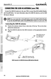
...the USB Connector on your aera 796. NOTE: You must subscribe to SiriusXM Radio and/or SiriusXM Satellite Weather to GXM 40 Antenna (XM Aviation Mounts)
146
Garmin aera 795/796 Pilot's Guide
190-01194-...40 Owner's Manual.
Overview
GPS Navigation
Appendix D
CONNECTING THE GXM 40 ANTENNA (aera 796)
Connect the GXM 40 antenna to the aera 796 to access SiriusXM Satellite Weather and SiriusXM ...
Quick Reference Guide - Page 9
B
Garmin aera 795/796 Quick Reference Guide
i Table of Contents
Section 1 Overview 1
1.1 Unit Overview...1 1.2 Getting Started...2
Battery Installation...2 Charging the Battery...4 GPS Receiver Status...4 Display Orientation...4 1.3 Operation...5 Basic Touchscreen Operation 5 Dedicated Icons...7 Page Buttons (Optional)...7 Main Menu...8 1.4 Menus and Data Entry 12 Option Menus...12 Data ...
Quick Reference Guide - Page 10

...® Weather (aera 796 33 4.2 Terrain...33 4.3 Traffic Information Service (TIS 34
Section 5 Utilities 35
5.1 Flight Log...35 5.2 Track Log...35 5.3 E6B Calculator...36 5.4 Aircraft Profile...37 5.5 Weight & Balance...38
Section 6 Appendix 39
Miscellaneous Message Advisories 39 Airspace Messages...40 Data Field & Numeric Data Options 41 Aural Alerts...43 Loss of GPS Position...43 Hazard...
Quick Reference Guide - Page 19

... Mosaic cloud cover. Storm Cells Displays Storm Cells.
B
Garmin aera 795/796 Quick Reference Guide
9 Lightning Displays Lightning. Intersection Displays nearest intersections.
WEATHER ICONS (aera 796)
From the Main Menu, touch the Weather icon to access the second-level Nearest icons. Overview
GPS Navigation
Flight Planning Hazard Avoidance
Overview
NEAREST ICONS
Touch the
icon...
Quick Reference Guide - Page 33

... map range. TEXTUAL WEATHER INFORMATION (AERA 796)
Textual weather information can be viewed several different ways. GPS Navigation
Overview
GPS Navigation
Flight Planning Hazard Avoidance
Or:... Plan Waypoints', 'Nearest Airports', or 'Recent Waypoints'). B
Garmin aera 795/796 Quick Reference Guide
23
Utilities
Appendix
Index NEAREST INFORMATION
Viewing nearest information:
1) Touch...
Quick Reference Guide - Page 41

...Plan from the Active Flight Plan, the aera 795/796 immediately begins to provide guidance to the first waypoint in which aircraft control is based solely upon flight instruments...., touch FPL List > Menu > Delete All > Yes.
3.7 APPROACHES
GPS Navigation
Flight Planning Hazard Avoidance
Utilities
WARNING: The aera 795/796 is available for monitoring purposes only.
Or:
a) From the Main Menu,...
Quick Reference Guide - Page 43

... 'Set Up Map' menu option. B
Garmin aera 795/796 Quick Reference Guide
33 a) Touch the 'Show/...TERRAIN
Enabling/Disabling Terrain Shading on the Navigation Map: 1) From the Main Menu touch the Map Icon. 2) Touch the Menu Icon. 3) Touch the 'Show/Hide...' Overview
GPS Navigation
Flight Planning Hazard Avoidance
Hazard Avoidance
SECTION 4 HAZARD AVOIDANCE
4.1 SiriusXM® WEATHER (aera 796...
Similar Questions


Upgrade 2.30 Mess Up My 796
I did this upgrade in December. Since new, and then with the last upgrade, the unite freezes. I nee...
I did this upgrade in December. Since new, and then with the last upgrade, the unite freezes. I nee...
(Posted by stefanmaldo 12 years ago)

My Aera 795 Shuts Down Or Freezes Periodically. Software Update Did Not Help.
My Aera 795 shuts down in flight, gets stuck reading pdfs. Garmin says next release of software may ...
My Aera 795 shuts down in flight, gets stuck reading pdfs. Garmin says next release of software may ...
(Posted by nick35852 12 years ago)