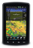
Garmin aera 796 Support Question
Garmin aera 796 Support Question
Find answers below for this question about Garmin aera 796.Need a Garmin aera 796 manual? We have 2 online manuals for this item!
Question posted by pilotjc on October 5th, 2013
Garmin Aera 796 Cannot Unlock Database
The person who posted this question about this Garmin product did not include a detailed explanation. Please use the "Request More Information" button to the right if more details would help you to answer this question.
Current Answers
Related Garmin aera 796 Manual Pages
Pilot's Guide - Page 6
... avoidance. Pilots using any outdated database do so entirely at their own risk.
Always refer to be used for hazardous weather penetration. WARNING: Do not use pressure altitude displayed by aera 795/796 GPS receivers is only to independently verify the accuracy of view or interfere with operating controls. Garmin aera 795/796 Pilot's Guide
190-01194...
Pilot's Guide - Page 7
...possible for erroneous operation to detect such an occurrence by means of the Garmin aera 795/796 utilize GPS as with all available navigation sources, including the information from government agencies. Warnings, Cautions & Notes
WARNING: The illustrations in the terrain and obstacle databases comes from other NAVAIDs, visual sightings, charts, etc. Therefore, as a precision electronic...
Pilot's Guide - Page 9
... eyewear may not reflect the most current aera 795/796 system and aviation databases. If you have any questions or would like additional information, please refer to cause cancer, birth defects, or reproductive harm. A
Garmin aera 795/796 Pilot's Guide
Moving the aircraft more than 100 yards away from GPS repeaters operating inside nearby hangars can cause...
Pilot's Guide - Page 13
......131
Appendix B: Abnormal Operation 133 Loss of GPS Position...133 Hazard Display with Loss of GPS Position 133
Appendix C: SD Cards and Databases 134 SD Card Use...134 Databases...135
Appendix D: Installation and Interfacing 139 Mounting the aera 795/796 in the Aircraft 139 Connecting to a Computer 143
190-01194-00 Rev. A
Garmin aera 795/796 Pilot's Guide
iii
Pilot's Guide - Page 19
Flight Planning Hazard Avoidance Additional Features
Appendices
Index
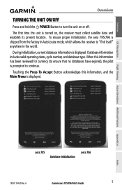
aera 795 Database Initialization
aera 796
190-01194-00 Rev. A
Garmin aera 795/796 Pilot's Guide
5 Database information includes valid operating dates, cycle number, and database type.
Overview
GPS Navigation
Overview
TURNING THE UNIT ON/OFF
Press and hold the POWER Button to turn the unit on , the receiver must ...
Pilot's Guide - Page 27
...Displays the aircraft's Present Position. Displays the Turbulence Forecast.
Overview
GPS Navigation
Flight Planning Hazard Avoidance Additional Features
Overview
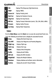
TFR PIREP Freeze.... Database Displays database and software version information. Displays Surface Pressure.
Profile
Displays Aircraft Profiles. Weight/Bal Displays the Weight & Balance.
A
Garmin aera 795/796 Pilot...
Pilot's Guide - Page 55

...00 Rev. Select 'Above Waypoint' to use field elevation for airports in the Jeppesen database or 'MSL' to specify an exact MSL altitude target.
• By-Enter ...a distance of distance 'Before' or 'After' a reference waypoint. A
Garmin aera 795/796 Pilot's Guide
41
Index GPS Navigation
Flight Planning Hazard Avoidance Additional Features
Appendices
Vertical Navigation
• Waypoint-...
Pilot's Guide - Page 58

... "V" before the route number.
Appendices
Index
44
Garmin aera 795/796 Pilot's Guide
190-01194-00 Rev. Overview
GPS Navigation
Additional Features Hazard Avoidance Flight Planning
GPS Navigation
AIRWAYS
Low Altitude Airways (or Victor Airways...
2.5 WAYPOINTS
Waypoints are predetermined geographical positions (internal database) or pilotentered positions, and are used for 45,000 feet MSL).
Pilot's Guide - Page 79

....
A
Garmin aera 795/796 Pilot's Guide
65 The active flight plan is erased when the destination is reached and the system is changed or updated, the aera 795/796 automatically updates...can be created and stored in the aera 795/796. Overview
GPS Navigation
SECTION 3 FLIGHT PLANNING
Flight Planning
3.1 INTRODUCTION
Flight planning on the aera 795/796 consists of building a flight plan ...
Pilot's Guide - Page 91

... (only available if an approach is used when being vectored to -Final are not activated, the aera 795/796 creates a straight-line course directly to Final symbol appears beside the first approach waypoint in the approach. When Vectors-to the final approach course by Air Traffic Control (ATC). A
Garmin aera 795/796 Pilot's Guide
77
Pilot's Guide - Page 99

...
GPS Navigation
Flight Planning Hazard Avoidance Additional Features
Hazard Avoidance
Storm Cell Data (Map)
METARS AND TAFS
Additional Storm Cell Information
NOTE: METAR information is shown next to the airport.
If METAR data is available for an airport, a color-coded flag is only displayed within the installed aviation database service area. A
Garmin aera 795/796...
Pilot's Guide - Page 109

...GPS Navigation
Hazard Avoidance
Viewing legends for primary terrain avoidance. Or: Touch the Back Icon to return to situational awareness. Terrain information is displayed. NOTE: Terrain depicted in the database...altitudes of the aircraft, and will change as an aid to the map. A
Garmin aera 795/796 Pilot's Guide
95
Index Or: a) From the Main Menu, touch the Weather Icon. ...
Pilot's Guide - Page 110

...projected point of proximity to be available in the Terrain Setup.
Terrain and obstacle databases are between 1,000 feet and 100 feet below the aircraft. Alert windows appear to...(GPS-MSL altitude) and is then converted to 5 nm or below the aircraft. Obstacles are displayed by satellite geometry, but is derived from satellite position. Appendices
Index
96
Garmin aera 795/796 ...
Pilot's Guide - Page 120

...fidelity on the Navigation Map. Appendices
Index
106
Garmin aera 795/796 Pilot's Guide
190-01194-00 Rev.
Cultural ...Vision imagery shows the relevant features in the obstacle database (if present). WARNING: Use appropriate systems for ...contours (colors are consistent with true north.
Overview
GPS Navigation
Additional Features Hazard Avoidance Flight Planning
Additional Features...
Pilot's Guide - Page 125
...Rev.
A
Garmin aera 795/796 Pilot's ...Guide
111
Appendices
Index
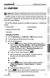
c) Enter the desired data using the keypad. b) Touch the 'Search' Button (between the ). If duplicate entries are displayed, touch the desired duplicate from the list.
4) Touch the buttons to display the desired search option on airport diagrams.
The ChartView database...Features
Overview
GPS Navigation
...
Pilot's Guide - Page 127
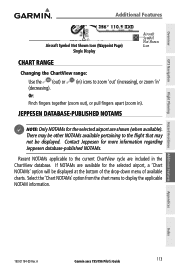
... together (zoom out), or pull fingers apart (zoom in the ChartView database. There may not be displayed at the bottom of the drop-down ... airport, a 'Chart NOTAMs' option will be displayed. Overview
GPS Navigation
Flight Planning Hazard Avoidance Additional Features
Additional Features
Aircraft Symbol ... A
Garmin aera 795/796 Pilot's Guide
113 Appendices
Index
190-01194-00 Rev.
Pilot's Guide - Page 128
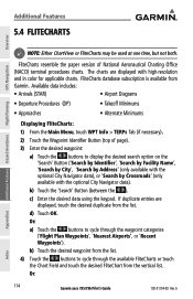
... from the vertical list. FliteCharts database subscription is available from the list...GPS Navigation
Additional Features Hazard Avoidance Flight Planning
NOTE: Either ChartView or FliteCharts may be used at one time, but not both. d) Touch OK. A
Appendices
Index c) Enter the desired data using the keypad.
b) Touch the desired waypoint from Garmin. Or:
114
Garmin aera 795/796...
Pilot's Guide - Page 131

... navigate to the chart feature. A
Garmin aera 795/796 Pilot's Guide
117 Activating the chart... pointer on a VFR/IFR chart: While viewing a Chart, touch anywhere on the Chart to activate the chart
pointer. Reviewing information for chart availability. Overview
GPS...). These indications are whether the databases are present at the Chart Pointer...
Pilot's Guide - Page 141
...message repeats at XXX Battery Low Can't Unlock Databases
Can't Unlock Maps
Check XM Antenna
Database Error
Fuel Tank
GPS antenna shorted to ground Lost Satellite Reception ...Garmin Product Support to ground.
You have the unit repaired.
The aircraft is nearing the destination. No applicable unlock code for one minute of reaching the initial VNAV decent point. A
Garmin aera 795/796...
Quick Reference Guide - Page 49
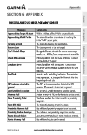
... is nearing a turn in a route. The reminder message repeats at XXX Battery Low Can't Unlock Maps
Check XM Antenna
Database Error
Fuel Tank
GPS antenna shorted to receive satellite signals. A route name that already exists has been entered. B
Garmin aera 795/796 Quick Reference Guide
39 The aircraft is unable to ground Lost Satellite Reception Memory...
Similar Questions


Cannot Unlock Database
Recently purchased a Garmin 796. Updated the database online through the Garmin website. After the u...
Recently purchased a Garmin 796. Updated the database online through the Garmin website. After the u...
(Posted by jefflittle1272 11 years ago)