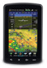
Garmin aera 796 Support Question
Garmin aera 796 Support Question
Find answers below for this question about Garmin aera 796.Need a Garmin aera 796 manual? We have 2 online manuals for this item!
Question posted by aryahen on August 20th, 2014
How Accurate Is Altitude Dta On The Garmin Aera 796
The person who posted this question about this Garmin product did not include a detailed explanation. Please use the "Request More Information" button to the right if more details would help you to answer this question.
Current Answers
Related Garmin aera 796 Manual Pages
Pilot's Guide - Page 6
... could vary significantly from third party sources. WARNING: The altitude calculated by aera 795/796 GPS receivers is obtained from the altitude displayed by the aircraft altimeter when determining or selecting aircraft altitude. Databases used in the aera 795/796 system must NOT be used for hazardous weather penetration.
Garmin aera 795/796 Pilot's Guide
190-01194-00 Rev. WARNING: Do...
Pilot's Guide - Page 7
..., visual sightings, charts, etc. WARNING: The Garmin aera 795/796 has a very high degree of the Garmin aera 795/796 utilize GPS as a precision electronic NAVigation AID (NAVAID). WARNING: The United States government operates the Global Positioning System and is solely responsible for all conceivable system failures is not practical.
Garmin accurately processes and cross-validates the data...
Pilot's Guide - Page 41

...Garmin aera 795/796..., Terrain Audio, TIS Audio
Units
Distance, Speed, Direction Display, Temperature, Altitude, Vertical
Speed, Pressure, Fluid Volume
Date/Time Time Format, Auto UTC...
Power Loss Warning
Keyboard Layout
Appendices
Index
190-01194-00 Rev. Overview
GPS Navigation
Flight Planning Hazard Avoidance Additional Features
Overview
ADDITIONAL SETTINGS
Changing settings (Units...
Pilot's Guide - Page 42
...reference waypoint 'Nearest Type' using the 'Change Nearest Type' menu option. Overview
GPS Navigation
Additional Features Hazard Avoidance Flight Planning
Overview
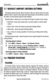
1.7 NEAREST AIRPORT CRITERIA SETTINGS
The ...GPS altitude, reference waypoint, type, distance, direction, and bearing. The pilot can be defined, as well as the option to filter out airports that order).
28
Garmin aera 795/796...
Pilot's Guide - Page 44

... the Main Menu, touch Tools > Position > Menu > Start/Stop
Simulator. GPS Navigation
Additional Features Hazard Avoidance Flight Planning
Appendices
Index
Drive Simulator
30
Garmin aera 795/796 Pilot's Guide
190-01194-00 Rev. Refer to Section 1.4 'Data Entry' for more information.
Adjusting the simulated altitude, track, speed, waypoint, & position: 1) From the Main Menu, touch Tools...
Pilot's Guide - Page 45

The aircraft position and the flight plan legs are accurately based on the navigation map. The leg of the aircraft to the..., therefore the relative position of the active flight plan currently being flown is shown as a magenta line on GPS calculations. A
Garmin aera 795/796 Pilot's Guide
31 Inactive Leg (White)
Active Leg (Magenta) Aircraft Icon
Flight Plan Legs (Navigation Map)
Appendices...
Pilot's Guide - Page 48

... HUMIDITY) • Wx (Temperature) (WX TEMP) • Wx (Wind) (WX WIND)
Appendices
Index
34
Garmin aera 795/796 Pilot's Guide
190-01194-00 Rev. Overview
GPS Navigation
Additional Features Hazard Avoidance Flight Planning
GPS Navigation
DATA FIELD OPTIONS
• Accuracy • Altitude • Bearing (BRG) • Course to Steer (CTS) • Desired Track (DTK) • Distance...
Pilot's Guide - Page 51
... from the present position to Steer', a specific heading reference ('User Selected'), or 'Off'. A
Garmin aera 795/796 Pilot's Guide
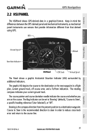
37 The graphic HSI depicts the course to the course line.
HSI
GPS Navigation
Flight Planning Hazard Avoidance Additional Features
Ground Speed
Altitude
Turn Rate Indicator
HSI/Panel
CDI Scale Vertical Speed
The Panel shows a graphic...
Pilot's Guide - Page 53
... Button
Returning to a final (target) altitude at a specified location. These settings create a three-dimensional profile from the present location and altitude to automatic sequencing of the progress by message alerts. Overview
GPS Navigation
3) Touch the Set OBS and Hold... the pilot is greater than 35 knots.
190-01194-00 Rev. A
Garmin aera 795/796 Pilot's Guide
39
Appendices
Index
Pilot's Guide - Page 54

...aera 795/796 is at the proper altitude for instrument approaches.
Overview
GPS Navigation
GPS Navigation
The "Approaching VNAV Profile" message appears one minute prior to prevent changes in speed from altering the profile.
CAUTION: VNAV is only a VFR navigation aid and is at the proper altitude... for the VNAV Profile.
40
Garmin aera 795/796 Pilot's Guide
190-01194-00 Rev.
Pilot's Guide - Page 55

... defines the target location.
• Profile-Enter the descent rate.
• Altitude-Enter the desired reference waypoint altitude. A
Garmin aera 795/796 Pilot's Guide
41
Index Overview
GPS Navigation
Configuring a VNAV profile: 1) From the Main Menu, touch Tools > VNAV 2) Touch the desired fields ('Profile', 'Altitude', etc) to enter the VNAV
profile. 3) Touch and hold the Back Icon...
Pilot's Guide - Page 58

... navigation. When both types of the facility, or by entering the city name.
Appendices
Index
44
Garmin aera 795/796 Pilot's Guide
190-01194-00 Rev.
Overview
GPS Navigation
Additional Features Hazard Avoidance Flight Planning
GPS Navigation
AIRWAYS
Low Altitude Airways (or Victor Airways) primarily serve smaller piston-engine, propeller-driven airplanes on shorter routes and...
Pilot's Guide - Page 76

...' On/Off Button. Airspace Alert Message
Smart Airspace
Smart Airspace shows airspace at all other altitudes are de-emphasized.
Appendices
Index
62
Garmin aera 795/796 Pilot's Guide
190-01194-00 Rev.
A
Overview
GPS Navigation
Additional Features Hazard Avoidance Flight Planning
GPS Navigation Airspace alert setup: 1) From the Main Menu, touch Tools > Setup > SUA Alarms. 2) Touch...
Pilot's Guide - Page 96

...82
Garmin aera 795/796 Pilot's Guide
190-01194-00 Rev. A NEXRAD Intensity
Colors are used to seven levels of cloud cover. An individual NEXRAD site cannot depict high altitude storms... and 55°N is displayed using colors corresponding to the dBZ values. Overview
GPS Navigation
Additional Features Hazard Avoidance Flight Planning
Hazard Avoidance
• NEXRAD base reflectivity is...
Pilot's Guide - Page 97

...using flags at the end of thunderstorms.
GPS Navigation
Flight Planning Hazard Avoidance Additional Features
Echo Tops Data
Echo Tops Altitudes
WINDS ALOFT
Winds Aloft data shows the ... radar and indicate the highest altitude at selected altitudes.
The wind barbs always point in 3,000-foot increments up to 42,000 feet MSL. A
Garmin aera 795/796 Pilot's Guide
83
The wind...
Pilot's Guide - Page 103

...FORECAST
Turbulence data identifies the potential for the lowest forecast altitude where icing conditions are likely to supplement AIRMETs and SIGMETs. Overview
GPS Navigation
Hazard Avoidance
FREEZING LEVELS
Freezing Level shows contours for erratic movement of high-altitude air mass associated winds. A
Garmin aera 795/796 Pilot's Guide
89 Turbulence is intended to occur. Turbulence data...
Pilot's Guide - Page 107

... 4) Touch the Weather 'Show/Hide' Button. A
Garmin aera 795/796 Pilot's Guide
93 METAR Selected with Map Pointer
Flight ...GPS Navigation
Hazard Avoidance
Viewing SiriusXM Weather products on the Weather Map: 1) From the Main Menu touch the Weather Icon. 2) Touch the desired second-level Weather Icon. 3) If necessary, touch the buttons to scroll through the list of available
altitudes...
Pilot's Guide - Page 150

...are included in following databases are provided by accurately displaying the aircraft position on a 28-...aera 795/796 Pilot's Guide
190-01194-00 Rev. Appendix C
Overview
GARMIN DATABASE INFORMATION
The following ground control instructions by Garmin:
• Worldwide Basemap
•
• Worldwide Terrain
•
• Obstacle
•
SafeTaxi FliteCharts IFR/VFR Charts
GPS...
Pilot's Guide - Page 168
... structure of the aircraft comes between the aircraft and
the Mode-S radar antenna. GPS Navigation
Additional Features Hazard Avoidance Flight Planning
NOTE: TIS is dependent on the next...the client aircraft.
154
Garmin aera 795/796 Pilot's Guide
190-01194-00 Rev. However, intruder distance and altitude typically remain relatively accurate and may be intermittent during a single radar...
Pilot's Guide - Page 180

...calculate winds accurately. Overview
GPS Navigation
Additional Features Hazard Avoidance Flight Planning
Appendix G
Calculating true airspeed and density altitude: 1) From the Main Menu, touch Tools > E6B Calc, enter the altitude shown
on ...Main Menu, touch Tools > Profile
Appendices
Index
166
Garmin aera 795/796 Pilot's Guide
190-01194-00 Rev.
A The unit can save up to define the...
Similar Questions

Arts 796 Flight Log
Can I export/download Flight Log from my Aera 796
Can I export/download Flight Log from my Aera 796
(Posted by paulbarbaro 2 years ago)


Aera 796 Alt Lags On Dept.
I get obstacle and terrain warnings for several min after departure till the alt readout catches up ...
I get obstacle and terrain warnings for several min after departure till the alt readout catches up ...
(Posted by vctrs4food 11 years ago)
