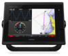
Garmin GPSMAP 7410 Support Question
Garmin GPSMAP 7410 Support Question
Find answers below for this question about Garmin GPSMAP 7410.Need a Garmin GPSMAP 7410 manual? We have 5 online manuals for this item!
Question posted by rcw1776 on May 14th, 2017
How To Select An Unmarked Destination
I would like to select an unmarked destination then plot a course to the point. Page 11 only says "select a destination", but does not tell you how.
Current Answers
Answer #1: Posted by 106lewis on May 16th, 2017 8:19 PM
106lewis

Member since:
May 16th, 2017 Points: 4,150
Member since:
May 16th, 2017 Points: 4,150
i think you should be looking at page 10 not 11. It has a section on destinations and choosing them, either by searching or using a chart. Once you have chosen your destination, you chart your route to it. You can even create a waypoint to save it for easy routing or to come back to the same place later. I hope this helps.


Related Garmin GPSMAP 7410 Manual Pages
Owner s Manual - Page 2

... organization of SD-3C, LLC. Garmin®, the Garmin logo, BlueChart®, g2 Vision®, GPSMAP®, Ultrascroll®, and VIRB® are registered trademarks of FLIR Systems, Inc. Windows® is a registered trademark of the National Marine Electronics Association. All rights reserved. Under the copyright laws, this product. FLIR® is a registered...
Owner s Manual - Page 3
...Point... Course ...Destination by Name 10 Selecting a Destination Using the Navigation Chart 10 Searching for a Marine Services Destination 10 Stopping Navigation 10 Waypoints 10 Marking Your Present Location as a Waypoint 10 Creating a Waypoint at a Different Location 10 Marking an SOS Location 10 Viewing a List of all Waypoints 10 Editing a Saved Waypoint 10 Moving a Saved Waypoint 11...
Owner s Manual - Page 8
... chartplotter. You can group them together into the card slot on the computer. 2 Go to www.garmin.com/support/software/marine.html. 3 Select Download next to GPSMAP Series with SD Card. 4 Read and agree to change appears only on all other screens, except for the SmartMode name and symbol. The SmartMode items ...
Owner s Manual - Page 11
... the course to the location, including turns, select
Route To. • To use data from both the heading line and the COG line on electronic chart ...destination. Heading is the direction the bow of your present speed. Premium Charts
CAUTION The Auto Guidance feature is an extension drawn on the chart. Carefully compare the course to help you can add angle markers to detailed marine...
Owner s Manual - Page 15
... that indicates the course to your destination. Preferred Depth: Sets the appearance of hazard colors for the Mariner's Eye 3D chart... compare the course to display on the chart based
on the map, at each steering helm in on electronic chart information.... models.
receiver with a Chartplotter
9 From the navigation chart, select Menu > Sailing > Laylines. List: Shows a list of the...
Owner s Manual - Page 16
... chartplotter sets a direct course back to the location. When a Garmin VHF radio is available with premium charts, in a compatible chartplotter. This is based on the Navigation chart, Fishing chart, Perspective 3D chart view, or Mariner's Eye 3D chart view. See Creating and Navigating a Route From Your Present Location, page 11. Selecting a Destination Using the Navigation...
Owner s Manual - Page 17

... Using Go To
CAUTION When using Go To, a direct course and a corrected course may pass over land or shallow water.
The last turn with your boat when you are off course, follow a direct course from the destination to a selected destination. 1 Select a destination (Destinations, page 10). 2 Select Navigate To > Go To. The chartplotter marks the location of the turn you add should...
Owner s Manual - Page 18
The corrected course is due to the settings for and Navigating a Saved Route Before you can use this feature on electronic chart information.
Browsing for and Navigating Parallel to a Saved Route Before you can select Back to a new location. 5 If necessary, select a point, and select Remove. 6 Select Done. Port.
• To navigate the route from the destination point used when...
Owner s Manual - Page 19
.... If an area at least once more familiar destinations that area, depending on the path or route. On the chart, the course through a narrow waterway. 1 Dock your boat.
NOTE: Auto Guidance is 3 feet. You can show tracks in open the Timed Arrival menu by selecting a point on the map data. NOTE: The minimum safe...
Owner s Manual - Page 25
...GPSMAP 7407xsv mounted at the front of the return, you can reduce the color gain or contrast. 1 From a sonar view, select Menu. 2 Select... two points on the SideVü sonar view. 1 From the SideVü sonar view, select a ...Selecting a Sonar Source This feature may not be configured on the Garmin Marine Network. This causes a loss in the upper-left corner. 2 Select a location. 3 Select...
Owner s Manual - Page 46
...destination selected requires navigation through a narrow waterway. 1 Dock your vessel or drop the anchor. 2 Select Settings > Preferences > Navigation > Auto
Guidance > Shoreline Distance > Normal. 3 Select a destination...course through a narrow waterway (Adjusting the Distance from Shore The Shoreline Distance setting indicates how close to known obstacles, select...: Selects a starting point for...
Owner s Manual - Page 47

... if you are off course by
a specified distance. Sonar Alarm Settings
NOTE: Some settings require external accessories.
Communications Settings
NMEA 0183 Settings Select Settings > Communications > NMEA 0183 Setup. You can set the Shoreline Distance setting to a weather device, such as a GXM device, and have moved more , using a different destination each internal NMEA 0183...
Owner s Manual - Page 52
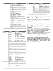
...RTE: Routes
VTG: Course over ground and ...selective calling information
DSE
Expanded digital selective calling
HDG
Heading, deviation, and variation
HDM
Heading, magnetic
MWD
Wind direction and speed
MDA
Meteorological composite
MWV
Wind speed and angle
VDM
AIS VHF data-link message
You can purchase complete information about National Marine Electronics...origin to destination)
BWC: ...
Owner s Manual - Page 53
...41 navigation chart 4, 6, 10, 37
aerial photos 8 marine service points 10 MARPA 9 radar overlay 25
47 See tacking and ... trip 32 wind 31 Go To 11 GPS 45 signals 2 source 2...courses 9 current stations 32 indicators 6
D data
backup 44 copying 44 data management 43 deleting, all user data 15 depth log 32 destinations navigation chart 10 selecting 10 device cleaning 44 registration 44 digital selective...
Camera Integration Guide - Page 1
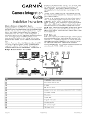
... before installation. Garmin GPSMAP 7400, 7600, and 8000 series chartplotters are compatible with multiple composite video inputs, only a single video function within a single video function. Camera Integration Guide
Installation Instructions
Marine Camera Integration Guide
Integrating FLIR® and Axis® network cameras with your Garmin® marine electronics provides superior video...
Camera Integration Guide - Page 2
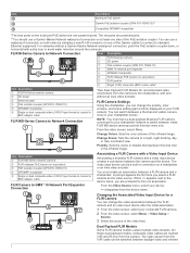
... docking, day, or man overboard view.
FLIR Camera Settings Using the chartplotter, you select a FLIR camera as the video source.
Change Scene: Sets the camera to GMS&#...10)
Ã
GPSMAP chartplotter
Ä
Single or dual composite video (V/IR) F-type female to coaxial to the chartplotters, with and without a Garmin Marine Network waterproof connection, point the PoE isolation ...
Camera Integration Guide - Page 3
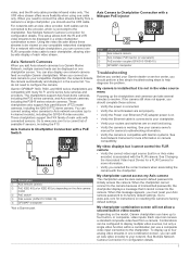
... stream. Go to www.axis.com for more information. • Verify you selected the correct camera when associating the camera with multiple chartplotters, you can take several... single chartplotter combination screen. Garmin GPSMAP 7400, 7600, and 8000 series chartplotters are on the model, Garmin chartplotters can have up to a Garmin Marine Network, multiple camera feeds can connect...
Installation Instructions - Page 1
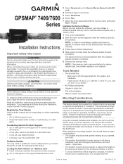
GPSMAP® 7400/7600 Series
Installation Instructions
Important Safety Information
WARNING See the Important Safety and ... in a location that is inserted. 3 Follow the on the computer. 2 Go to www.garmin.com/support/software/marine.html.
3 Select Download next to Garmin Marine Network with SD card.
4 Read and agree to these considerations. • The location should be installed closer to...
Installation Instructions - Page 6
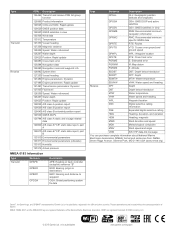
...minimum specific GNSS data
GPRTE
RTE: Routes
GPVTG
VTG: Course over ground and ground speed
GPWPL
WPL: Waypoint location
...Garmin®, the Garmin logo, and GPSMAP® are registered trademarks of the National Marine Electronics Association. These trademarks may not be...controller (autopilot) sentence "B"
BOD: Bearing (origin to destination)
BWC: Bearing and distance to waypoint
GGA: Global...
?Declaration of Conformity - Page 1
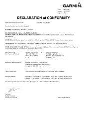
... Information technology equipment - Issued: 12/2/2015 Revised: 11/4/2016 Page: 1 of 1
DECLARATION of CONFORMITY
Application of Equipment:
Marine Navigation Equipment (Global Positioning System Receiver)
Model Number(s):
GPSMAP 7410, GPSMAP 7410xsv, GPSMAP 7410 J1939, GPSMAP 7410xsv J1939 GPSMAP 7412, GPSMAP 7412xsv, GPSMAP 7412 J1939, GPSMAP 7412xsv J1939
The undersigned does hereby declare...
Similar Questions

Shows Depth Occasionally.
All connections are clean and tight. Shows - - at the dock. Took it out and it started showing depth...
All connections are clean and tight. Shows - - at the dock. Took it out and it started showing depth...
(Posted by avola 10 months ago)
Which Pins?
when looking into rear power plug which pins are Pos/Neg
when looking into rear power plug which pins are Pos/Neg
(Posted by Jejeunesse 1 year ago)

Incorrect Speed Reading (knots)
Am Not Getting A Correct Speed Reading And I Have Been Into The Settings And Manually Changed And Tr...
Am Not Getting A Correct Speed Reading And I Have Been Into The Settings And Manually Changed And Tr...
(Posted by glenlark 9 years ago)

Gsd 24
Red power light blinking also unit says transducer and sonar turn off
Red power light blinking also unit says transducer and sonar turn off
(Posted by cbylund 9 years ago)

'map Locked Out' Message In My Garmin 740s With Bluechart G2 Vision Sd
With my new BlueChart g2 Vision SD card VUS010R installed in my Garmin 740s GPSMap, upon start-up, I...
With my new BlueChart g2 Vision SD card VUS010R installed in my Garmin 740s GPSMap, upon start-up, I...
(Posted by kwtailhkr 10 years ago)