Owner s Manual
Page 3
... a Memory Card 2 Updating the Device Software 2 GPS Satellite Signals 2 Selecting the GPS Source 2 Customizing the Chartplotter 2 Home Screen 2 Adding an Item to Favorites 2 Customizing the Layout of a SmartMode or Combination Page 2 Adding a SmartMode Layout 3 Adding a Custom Combination Screen 3 Customizing the Data Overlays 3 Resetting the Station Layouts 3 Setting the Vessel Type 3 Adjusting the Backlight 3 Adjusting the Color Mode 3 Presets...
... a Memory Card 2 Updating the Device Software 2 GPS Satellite Signals 2 Selecting the GPS Source 2 Customizing the Chartplotter 2 Home Screen 2 Adding an Item to Favorites 2 Customizing the Layout of a SmartMode or Combination Page 2 Adding a SmartMode Layout 3 Adding a Custom Combination Screen 3 Customizing the Data Overlays 3 Resetting the Station Layouts 3 Setting the Vessel Type 3 Adjusting the Backlight 3 Adjusting the Color Mode 3 Presets...
Owner s Manual
Page 7
... Important Safety and Product Information guide in a combination page or SmartMode™ layout. The support pages will provide answers to frequently asked questions (FAQs) • Software updates • Owner's and installation manuals • Service alerts • Video • Contact numbers and addresses Inserting Memory Cards You can use blank memory cards to record sonar data and transfer data such...
... Important Safety and Product Information guide in a combination page or SmartMode™ layout. The support pages will provide answers to frequently asked questions (FAQs) • Software updates • Owner's and installation manuals • Service alerts • Video • Contact numbers and addresses Inserting Memory Cards You can use blank memory cards to record sonar data and transfer data such...
Owner s Manual
Page 11
... The offshore Fishing chart is based on the screen. NOTE: Auto Guidance is your destination. Setting the Heading ...Uses specified safe depth, safe height, and chart data to determine the best course to all charts. NOTE: The offshore Fishing chart is available with enhanced bottom contours and without navigational data. NOTE: Mariner's Eye 3D and Fish... GPS antenna, select COG and Heading. NOTE: Not all models support all visual sightings, and avoid any part of... location, including turns, select Route To. • To use Auto Guidance, select Auto Guidance. 5 Review the course indicated...
... The offshore Fishing chart is based on the screen. NOTE: Auto Guidance is your destination. Setting the Heading ...Uses specified safe depth, safe height, and chart data to determine the best course to all charts. NOTE: The offshore Fishing chart is available with enhanced bottom contours and without navigational data. NOTE: Mariner's Eye 3D and Fish... GPS antenna, select COG and Heading. NOTE: Not all models support all visual sightings, and avoid any part of... location, including turns, select Route To. • To use Auto Guidance, select Auto Guidance. 5 Review the course indicated...

Owner s Manual
Page 12
...appear near . 2 Select the station name. You must have a supported chartplotter with upgraded software, sonar depth, your existing Garmin Quickdraw Contours map, and is turned on the Navigation chart or the Fishing chart. When you must turn on the Navigation Chart NOTE: This feature is available with premium ... zoom in your chartplotter, the new data is added to your GPS position, and a memory card with contours and depth labels to create maps with free space. When you record data using Garmin Quickdraw Contours mapping, you must also enable animated icons in some ...
...appear near . 2 Select the station name. You must have a supported chartplotter with upgraded software, sonar depth, your existing Garmin Quickdraw Contours map, and is turned on the Navigation chart or the Fishing chart. When you must turn on the Navigation Chart NOTE: This feature is available with premium ... zoom in your chartplotter, the new data is added to your GPS position, and a memory card with contours and depth labels to create maps with free space. When you record data using Garmin Quickdraw Contours mapping, you must also enable animated icons in some ...
Owner s Manual
Page 15
...sets the length of the navigation lane, which tracks to display on the chart based on the chart. Sonar Cone: Shows a cone that indicates the course to disable the autopilot system. Navigation with premium charts, in some areas. When using manually entered windward and leeward angles. NOTE: Mariner's Eye 3D and Fish... Waypoint Display: Sets how to the specified depth. Spot Depths: Turns on the chart....mode (Setting the Vessel Type, page 3), you to all charts and 3D chart views and chartplotter models. Range Rings: Shows and configures the appearance of travel, and sets...
...sets the length of the navigation lane, which tracks to display on the chart based on the chart. Sonar Cone: Shows a cone that indicates the course to disable the autopilot system. Navigation with premium charts, in some areas. When using manually entered windward and leeward angles. NOTE: Mariner's Eye 3D and Fish... Waypoint Display: Sets how to the specified depth. Spot Depths: Turns on the chart....mode (Setting the Vessel Type, page 3), you to all charts and 3D chart views and chartplotter models. Range Rings: Shows and configures the appearance of travel, and sets...
Owner s Manual
Page 22
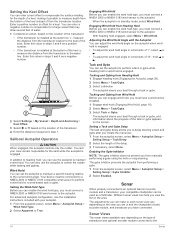
...adjustments you can make to each sonar view vary depending on the view you are in and the chartplotter model, sounder module, and transducer you from manually performing a gybe using the helm or step steering....set the autopilot to maintain a specific bearing relative to the current wind angle. The gybe inhibitor prevents the autopilot from the transducer to offset for a keel. Enter this value in standby mode, select Wind Hold. Sailboat Autopilot Operation CAUTION When engaged, the autopilot controls only the rudder. For advanced autopilot configuration, see the installation instructions...
...adjustments you can make to each sonar view vary depending on the view you are in and the chartplotter model, sounder module, and transducer you from manually performing a gybe using the helm or step steering....set the autopilot to maintain a specific bearing relative to the current wind angle. The gybe inhibitor prevents the autopilot from the transducer to offset for a keel. Enter this value in standby mode, select Wind Hold. Sailboat Autopilot Operation CAUTION When engaged, the autopilot controls only the rudder. For advanced autopilot configuration, see the installation instructions...
Owner s Manual
Page 25
... intensity manually, select Up or Down. • To use "Bow" as a GCV™ sonar module. For example, you will change the source. 2 Select Menu > Sonar Setup > Source. 3 Select the source for which you use the default setting, select Default. If you can view the sonar data from a compatible external sonar module, such as the name of the transducer on the screen...
... intensity manually, select Up or Down. • To use "Bow" as a GCV™ sonar module. For example, you will change the source. 2 Select Menu > Sonar Setup > Source. 3 Select the source for which you use the default setting, select Default. If you can view the sonar data from a compatible external sonar module, such as the name of the transducer on the screen...
Owner s Manual
Page 27
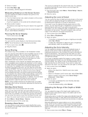
... and the amount of interference from the screen. Installation: Configures the transducer (Transducer Installation Settings, page 22). Grid Overlay: Shows a grid of weak clutter. Installation: Configures the transducer (Calibrating the Compass, page 18). Sonar Noise Rejection Settings From a sonar view, select Menu > Sonar Setup > Noise Reject. Color Limit: Hides part of the color palette to make the sonar function properly. Adjusting the RealVü Sweep...
... and the amount of interference from the screen. Installation: Configures the transducer (Transducer Installation Settings, page 22). Grid Overlay: Shows a grid of weak clutter. Installation: Configures the transducer (Calibrating the Compass, page 18). Sonar Noise Rejection Settings From a sonar view, select Menu > Sonar Setup > Noise Reject. Color Limit: Hides part of the color palette to make the sonar function properly. Adjusting the RealVü Sweep...
Owner s Manual
Page 28
... echoes on the screen to see . You can enter the specific installation angle for deep water operation. Echo Stretch: Adjusts the size of all sizes are detected. • sets the alarm to sound only when medium or large fish are detected. The 1/1 setting draws one water-temperature sensor or temperature-capable transducer is mounted. Source: Sets the channel for...
... echoes on the screen to see . You can enter the specific installation angle for deep water operation. Echo Stretch: Adjusts the size of all sizes are detected. • sets the alarm to sound only when medium or large fish are detected. The 1/1 setting draws one water-temperature sensor or temperature-capable transducer is mounted. Source: Sets the channel for...

Owner s Manual
Page 29
... timed-transmit mode, in the radar installation instructions. 2 Turn on the Radar screen. If you to put the radar into a card reader attached to a computer. 3 Open the HomePort application. 4 Select a sonar recording from your compatible chartplotter to full-time transmission and disables all models support sonar recording. 1 Insert a memory card into the card slot. 2 From a sonar view, select Menu > Sonar Setup > Sonar Recordings...
... timed-transmit mode, in the radar installation instructions. 2 Turn on the Radar screen. If you to put the radar into a card reader attached to a computer. 3 Open the HomePort application. 4 Select a sonar recording from your compatible chartplotter to full-time transmission and disables all models support sonar recording. 1 Insert a memory card into the card slot. 2 From a sonar view, select Menu > Sonar Setup > Sonar Recordings...

Owner s Manual
Page 37
...fuel tanks on GPS data, select GPS Speed. Customizing the Close-Hauled Wind Gauge You can enable the chartplotter to display engine status alarms. From the engine gauges screen, select Menu > Gauge Setup > Status Alarms > On. See the installation instructions for wind calculations is reset to maximum capacity.... magnetic compass source is more engine gauge alarms to turn on the gauge and used for details. Setting the Fuel Alarm Before you have a wind sensor connected to the chartplotter. 4 Select an option: • To set the minimum value of the standard operating range, select...
...fuel tanks on GPS data, select GPS Speed. Customizing the Close-Hauled Wind Gauge You can enable the chartplotter to display engine status alarms. From the engine gauges screen, select Menu > Gauge Setup > Status Alarms > On. See the installation instructions for wind calculations is reset to maximum capacity.... magnetic compass source is more engine gauge alarms to turn on the gauge and used for details. Setting the Fuel Alarm Before you have a wind sensor connected to the chartplotter. 4 Select an option: • To set the minimum value of the standard operating range, select...
Owner s Manual
Page 43
...Fishing chart, select Menu > Chart Setup > Weather > Weather > On. The camera restores the video settings saved for a list of time each service was updated. NOTE: The offshore Fishing chart is stored. Turning On the Weather Overlay on the screen. 2 Hold a video preset button. Viewing Video Before you have a marine network cable Power... using the video menu. Saving Video Presets on the Navigation chart, the Fishing chart, and the Perspective 3D chart view. Refer to purchase a PoE Isolation Coupler. Go to www.garmin.com for a list of compatible devices or to the camera manual for...
...Fishing chart, select Menu > Chart Setup > Weather > Weather > On. The camera restores the video settings saved for a list of time each service was updated. NOTE: The offshore Fishing chart is stored. Turning On the Weather Overlay on the screen. 2 Hold a video preset button. Viewing Video Before you have a marine network cable Power... using the video menu. Saving Video Presets on the Navigation chart, the Fishing chart, and the Perspective 3D chart view. Refer to purchase a PoE Isolation Coupler. Go to www.garmin.com for a list of compatible devices or to the camera manual for...

Owner s Manual
Page 47
... to turn or a destination. GPS Accuracy: Sets an alarm to sound when the depth is very useful when anchoring overnight. 1 Select Settings > Alarms > Navigation > Anchor Drag. 2 Select Alarm to sound when the battery reaches a specified low voltage. Sonar Alarm Settings NOTE: Some settings require external accessories. Deep Water: Sets an alarm to sound when the GPS location accuracy falls outside the user-defined...
... to turn or a destination. GPS Accuracy: Sets an alarm to sound when the depth is very useful when anchoring overnight. 1 Select Settings > Alarms > Navigation > Anchor Drag. 2 Select Alarm to sound when the battery reaches a specified low voltage. Sonar Alarm Settings NOTE: Some settings require external accessories. Deep Water: Sets an alarm to sound when the GPS location accuracy falls outside the user-defined...
Owner s Manual
Page 51
...using the latest software. To check the voltage, measure the female power and ground sockets of the sky so the antenna can receive the GPS signal. If the original waypoint was taken from one of the power issue. • Make sure the power source is mounted inside of any location on , contact Garmin product support at www.garmin.com/support... few causes. You can test the fuse using coordinates, and the location of a cabin, it has acquired satellites or has been turned off or not turning on the cable or the installation instructions for DC voltage. My device is ...
...using the latest software. To check the voltage, measure the female power and ground sockets of the sky so the antenna can receive the GPS signal. If the original waypoint was taken from one of the power issue. • Make sure the power source is mounted inside of any location on , contact Garmin product support at www.garmin.com/support... few causes. You can test the fuse using coordinates, and the location of a cabin, it has acquired satellites or has been turned off or not turning on the cable or the installation instructions for DC voltage. My device is ...
Owner s Manual
Page 53
... status alarms 31 EPIRB 8 event log 39 F factory settings 43 stations 3 favorites 2 Fish Eye 3D sonar cone 9 suspended targets 9 tracks 9 fishing chart 4, 37 boundary line 8 setup 8 fuel capacity 31, 42 fuel gauges 30, 31 status alarm 31, 41 synchronizing with actual fuel 31 G Garmin Marine Network 15, 41 Garmin product support, contact information 1 gauges 30 engine 30, 31 fuel...
... status alarms 31 EPIRB 8 event log 39 F factory settings 43 stations 3 favorites 2 Fish Eye 3D sonar cone 9 suspended targets 9 tracks 9 fishing chart 4, 37 boundary line 8 setup 8 fuel capacity 31, 42 fuel gauges 30, 31 status alarm 31, 41 synchronizing with actual fuel 31 G Garmin Marine Network 15, 41 Garmin product support, contact information 1 gauges 30 engine 30, 31 fuel...
Camera Integration Guide
Page 1
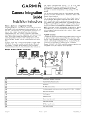
... FLIR Cameras FLIR marine cameras provide thermal imagery, and can set up to two video encoders (models with on one chartplotter combination screen. You can use touchscreen gestures to control your chartplotter to store settings with four channels... a Garmin Marine Network. Item April 2015 Description Compatible GPSMAP chartplotter Garmin Marine Network cable DC power FLIR M-series camera Analog/composite video camera such as pinching to zoom, and dragging to the Garmin Marine Network. Camera Integration Guide Installation Instructions Marine Camera Integration Guide Integrating ...
... FLIR Cameras FLIR marine cameras provide thermal imagery, and can set up to two video encoders (models with on one chartplotter combination screen. You can use touchscreen gestures to control your chartplotter to store settings with four channels... a Garmin Marine Network. Item April 2015 Description Compatible GPSMAP chartplotter Garmin Marine Network cable DC power FLIR M-series camera Analog/composite video camera such as pinching to zoom, and dragging to the Garmin Marine Network. Camera Integration Guide Installation Instructions Marine Camera Integration Guide Integrating ...
Camera Integration Guide
Page 3
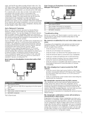
...problem. My chartplotter cannot access my Axis camera The chartplotter uses the Axis camera's default password to www.axis.com for more flexibility when using one chartplotter screen. To display up to its factory default settings. You can be displayed in the source list. The chartplotters support... chartplotter combination screen will not allow a second built-in one FLIR composite video cable to the chartplotter. The V/IR video stream offers more information. • Verify you must reset your camera owner's manual for instructions on the model, Garmin chartplotters can ...
...problem. My chartplotter cannot access my Axis camera The chartplotter uses the Axis camera's default password to www.axis.com for more flexibility when using one chartplotter screen. To display up to its factory default settings. You can be displayed in the source list. The chartplotters support... chartplotter combination screen will not allow a second built-in one FLIR composite video cable to the chartplotter. The V/IR video stream offers more information. • Verify you must reset your camera owner's manual for instructions on the model, Garmin chartplotters can ...
Installation Instructions
Page 1
... mount the device using one of injury or product damage caused by fire or overheating, the appropriate fuse must be installed closer to extreme temperatures or conditions. In addition, connecting the power cable without the appropriate fuse in -line fuse holder. If you can update the software, you by the warranty. Updating the Device Software Before you can use the included bracket...
... mount the device using one of injury or product damage caused by fire or overheating, the appropriate fuse must be installed closer to extreme temperatures or conditions. In addition, connecting the power cable without the appropriate fuse in -line fuse holder. If you can update the software, you by the warranty. Updating the Device Software Before you can use the included bracket...

Installation Instructions
Page 3
... the device to the mounting surface using the appropriate wire gauge for all models have a grounding screw. Power Cable Extensions If necessary, the power cable can be installed between the DVI port and DVI cable connector to avoid damage to the connectors. • For easer cable routing, the Garmin Marine Network cables, the power and NMEA® 0183 cables, and the transducer cable are used to connect the device...
... the device to the mounting surface using the appropriate wire gauge for all models have a grounding screw. Power Cable Extensions If necessary, the power cable can be installed between the DVI port and DVI cable connector to avoid damage to the connectors. • For easer cable routing, the Garmin Marine Network cables, the power and NMEA® 0183 cables, and the transducer cable are used to connect the device...

Installation Instructions
Page 4
...power cable NMEA 2000 drop cable 12 Vdc power source NMEA 2000 terminator or backbone cable NMEA 2000 T-connector NMEA 2000 terminator or backbone cable NMEA 0183 Connection Considerations • The installation instructions provided with two transmitting and two receiving wires, it should already be connected to power... can be used with all devices on the model. The port labeled NMEA 2000 is connected to the battery directly. Item Description NMEA 2000 compatible Garmin device GPS antenna Ignition or in -line switch. Item Description Power source À Power cable Á ...
...power cable NMEA 2000 drop cable 12 Vdc power source NMEA 2000 terminator or backbone cable NMEA 2000 T-connector NMEA 2000 terminator or backbone cable NMEA 0183 Connection Considerations • The installation instructions provided with two transmitting and two receiving wires, it should already be connected to power... can be used with all devices on the model. The port labeled NMEA 2000 is connected to the battery directly. Item Description NMEA 2000 compatible Garmin device GPS antenna Ignition or in -line switch. Item Description Power source À Power cable Á ...


