Garmin GPSMAP 64s Support Question
Garmin GPSMAP 64s Support Question
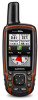
Find answers below for this question about Garmin GPSMAP 64s.Need a Garmin GPSMAP 64s manual? We have 4 online manuals for this item!
Question posted by adhgna on April 17th, 2017
Tracking Manager
I want to record the geographical coordinate with 100m interval, How can i set my Garmin GPS 64s in order record the coordinate of the path automatically.
Current Answers


Related Garmin GPSMAP 64s Manual Pages
Important Safety and Product Information - Page 4

... services that are obtained and/or used only as batteries, unless product damage has occurred due to a defect in contravention of the laws of Garmin; Write the tracking number clearly on the country. Send the device, freight charges prepaid, to the customer for parts or labor, provided that has been modified or...
Declaration of Conformity - Page 1
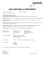
... CONFORMITY
Application of Equipment:
Information Technology Equipment (Global Positioning System Receiver)
Model Number(s):
GPSMAP 64 GPSMAP 64s GPSMAP 64st
The undersigned does hereby declare that the equipment complies with the above Directives
Jamie Wiltshire Quality Supervisor Garmin (Europe) Ltd. Limits and methods of measurement
IEC 61000-6-1:2007 Electromagnetic compatibility (EMC...
Owner's Manual - Page 1
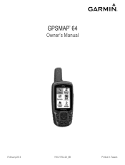
GPSMAP® 64
Owner's Manual
February 2014
190-01702-00_0B
Printed in Taiwan
Owner's Manual - Page 2

... to make changes in the United States and other countries. Windows® is a registered trademark of Garmin. Other trademarks and trade names are trademarks of SD-3C, LLC.
Garmin®, the Garmin logo, City Navigator®, and GPSMAP® are those of Microsoft Corporation in the content of this manual without obligation to www...
Owner's Manual - Page 3
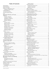
... Stopping Navigation 3 Reversing a Route 3 Tracks 3 Tracks Settings 3 Viewing the Current Track 3 Saving the Current Track 3 Clearing the Current Track 3 Deleting a Track 3 Navigating a Saved Track 3 Purchasing Additional Maps 3 Finding an ...Accessories 11 Tips for Pairing ANT + Accessories with Your Garmin Device . 11 Data Management 11 File Types 11 Installing a Memory Card 11 ...
Owner's Manual - Page 5

...wall outlet or a USB port on GPSMAP 64s and GPSMAP 64st models only.
3 Insert the ... turn the D-ring clockwise. Installing Batteries
The handheld device operates using the optional NiMH battery pack ...a battery that was not provided by Garmin can rupture at high temperatures.
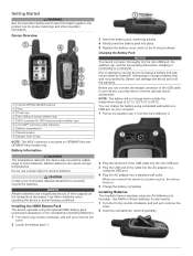
Introduction
... operating the device in the product box for GPS antenna (under weather cap) Å microSD&#...
Owner's Manual - Page 6
....
shows the GPS/GLONASS signal strength. When the bars are locations you record and store in.... 1 Select Waypoint Manager. 2 Select a waypoint. 3 Select an item to edit, such as a waypoint.
Waypoints, Routes, and Tracks
Acquiring Satellite Signals
It...the point on the map, select Review. • To change the order of measure. 6 Enter the distance, and select Done. 7 Select Save...
Owner's Manual - Page 7
...another location on or off.
Map Settings Select Setup > Map.
Recording Interval: Sets a track log recording rate. Auto Archive: Sets an automatic archive method to choose the active main page. Clearing the Current Track Select Track Manager > Current Track > Clear Current Track. From any page, select MENU twice. As you travel at (www.garmin.com). 2 Click the Maps tab. 3 Follow...
Owner's Manual - Page 8

...or overhead power lines. Display: Sets the type of drift (right or left) from an electronic compass to your path. NOTE: Your customized settings are moving long distances, experiencing ...GPSMAP 64s and GPSMAP 64st. 1 Select Sight 'N Go. 2 Point the device at the top.
By default, the elevation plot displays the elevation over the distance traveled. Compass: Automatically...
Owner's Manual - Page 9

... perimeter of the area you enter an area with the GPSMAP 64s and GPSMAP 64st.
Elevation/Distance: Records elevation changes over a period of time. Reset Trip Data: Resets all saved waypoints.
When you want to factory settings.
Main Menu Features and Settings
5
Clear Current Track: Deletes the track log.
Sending and Receiving Data Wirelessly
NOTE: This feature is...
Owner's Manual - Page 10

... to Garmin Connect: Automatically sends your activity to share your journeys with GPSMAP 64s and GPSMAP 64st. 1 Bring your compatible smartphone within 33 ft. (10 m) of the screen. Use Demo Mode: Allows you must enable the remote setting on your compatible smartphone, enter the passkey. For more accuracy.
For best results, collect four to create and manage...
Owner's Manual - Page 12
...Positioning System (DGPS) information from the original path of travel . NOTE: Changing the text ...track data with
most NMEA 0183-compliant mapping programs by creating a virtual serial port. Garmin Serial: Sets the device to use the device USB port with a computer. Setting the Device Tones
You can customize tones for this data to GPS, GPS +
GLONASS , or Demo Mode (GPS...
Owner's Manual - Page 13

... while anchored, when you are watching for pressure fronts.
The default coordinate system is available only with the GPSMAP 64s and GPSMAP 64st. Select Setup > Altimeter. Plot Type: Records elevation changes over a period of time or distance, records barometric pressure over a period of time, or records ambient pressure changes over a period of chart the device uses
when...
Owner's Manual - Page 15
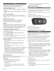
...garmin.com/ trip _ planning. • GPX track files. • GPX geocache files. Connecting the Device to Your Computer
NOTICE To prevent corrosion, thoroughly dry the mini-USB port, the weather cap, and the surrounding area before charging or connecting to your Garmin device automatically...with your Garmin dealer. Use lithium batteries when operating the device in the handheld device for...
Owner's Manual - Page 17
...files, transferring 5, 11
G Garmin Connect 6 Garmin Express 10
registering the device 10 updating software 10 geocaches 5, 11 downloading 5 GLONASS 10 GPS 5 satellite page 5 settings 8
H HomePort 11 hunting and...and sunset times 7 system settings 8
T tempe 11 temperature 11 time settings 9 time zones 9 tones 8 tracks 3, 6
navigating 3 settings 3 transferring files 5, 6, 11 tracks 5
trip computer 4 ...
Quick Start Manual - Page 1

GPSMAP® 64
Quick Start Manual
February 2014
190-01702-01_0B
Printed in Taiwan
Quick Start Manual - Page 2
...GPSMAP 64s and GPSMAP 64st models only. Before you can damage the device and void the warranty.
When you may exceed the usable range of the USB cable to your device, you connect the device to properly recycle the batteries. Installing Batteries The handheld... temperature rating for GPS antenna (under weather... that was not provided by Garmin can connect the straight connector ...
Quick Start Manual - Page 3

..., select Track Manager > Current
Track. 2 Select an option:
• To show the current track on the map. Map represents your path. Changing the Map Orientation 1 From the map, select MENU. 2 Select Setup Map > Orientation. 3 Select an option:
• Select North Up to show north at
the top of waypoints or locations that is a recording of the...
Quick Start Manual - Page 4

... odometer, and other extras
Setting Up Garmin Express 1 Plug the small end of the USB cable into an available USB
port on the GPSMAP 64s and GPSMAP 64st. 1 Select Sight ...setting is known. 2 Select PAGE > Elevation Plot > MENU > Calibrate
Altimeter. 3 Follow the on -screen instructions.
Getting the Owner's Manual You can install a microSD memory card in the handheld device for Garmin...
Quick Start Manual - Page 6
... 52 54 +420 221 985466 +420 221 985465
+385 1 5508 272 +385 1 5508 271 + 45 4810 5050
+ 358 9 6937 9758
+ 331 55 69 33 99
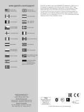
Garmin®, the Garmin logo, and GPSMAP® are trademarks of such marks by the Bluetooth SIG, Inc. deutschen Festnetz, Mobilfunk max. 60 ct./Anruf...
Similar Questions

Distance Covered
why does my 64s always show greater distances on the trip page than actually walked?
why does my 64s always show greater distances on the trip page than actually walked?
(Posted by Anonymous-158104 8 years ago)

Dove Posso Trovare Un Manuale D'uso Completo Per Gpsmaps64s Grazie
(Posted by giancarlomillex 8 years ago)

Saving A Route
how do you save a route that you already have mapped on your garmin 64s
how do you save a route that you already have mapped on your garmin 64s
(Posted by loricleggett 8 years ago)

Does The Garmin Montana 600 Gps Have Track Manager
(Posted by jdmivgisl 9 years ago)
Garmin Rino 650 Shuts Off When I View Map In Track Manager
(Posted by nimastheap 10 years ago)