Garmin GPSMAP 5212 Support Question
Garmin GPSMAP 5212 Support Question
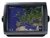
Find answers below for this question about Garmin GPSMAP 5212 - Marine GPS Receiver.Need a Garmin GPSMAP 5212 manual? We have 9 online manuals for this item!
Question posted by chasman87 on January 30th, 2012
I Need Help Unlocking The Maps On My Garmin 5212 Chart Plotter
I need to know how to unlock the Maps on My Garmin 5212 chartplotter
Current Answers
Related Garmin GPSMAP 5212 Manual Pages
Important Safety and Product Information - Page 1
... resolve any purpose requiring precise measurement of California to mariners contain all available navigation sources, including information from visual sightings, local waterway rules and restrictions, and maps. Official government charts and notices to cause cancer, birth defects, or reproductive harm. See www.garmin.com/prop65 for any discrepancies or questions before continuing...
Important Safety and Product Information - Page 3
...GPS unit.
• Consult the dealer or an experienced radio/TV technician for help. Unauthorized repairs or modifications could result in a residential installation. Limited Warranty
This Garmin...software or offer a full refund of map data in normal use. This product ... or relocate the receiving antenna.
• Increase the separation between the equipment and the receiver.
• Connect...
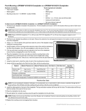
Installation Instructions - Page 2
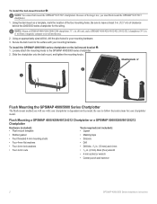
...-3/8 in. (10 mm) and 4 mm
• Four 4-mm nuts
• 1/16 in . (1 m) from a magnetic compass to avoid interference. 2. NOTE: Mount a GPSMAP 4008/4208/5008/5208 chartplotter 31 1/2 in. (80 cm), and a GPSMAP 4010/4210/4012/4212/5012/5212 chartplotter 39 3/8 in . (2 mm) Allen (Hex) wrench
• 4 mm socket or wrench
• Center punch and hammer...
Installation Instructions - Page 3
... studs ×4
Flat washers ×4
Lock washers ×4
Rubber gasket Mounting surface
Hex nuts ×4
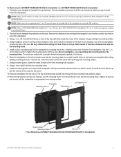
Flush Mounting a GPSMAP 4008/4208/4012/4212/5008/5208/5012/5212 Chartplotter
GPSMAP 4000/5000 Series Installation Instructions
The flush-mount template is snug against the mounting surface.
Using a 3/8 in . (13 mm) of space on the back of ...
Installation Instructions - Page 4
...the pilot holes need
to avoid ...chartplotter in the hole, and make sure to access the SD card door.. Garmin recommends applying an anti-galling, stainless antiseize lubricant to the front of the chartplotter...help to avoid any cracking in the location where you mount the chartplotter has at which you want to drill a clearance-counterbore through the chartplotter into place.
GPSMAP...
Installation Instructions - Page 18
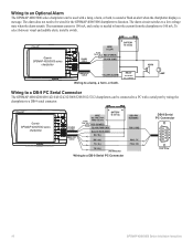
.../5012/5212 chartplotters can be used with a serial port by wiring the
chartplotter to 100 mA.
The alarm does not need to be wired for
Fuse wire colors 7.5 A - 42 V Red (power)
+
-
Wiring to an Optional Alarm
The GPSMAP 4000/5000 series chartplotter can be connected to a PC with a lamp, a horn, or both . Garmin GPSMAP 4000/5000 series
chartplotter
Power...
Owner's Manual - Page 12
...
Current Station
Marine Services
*Some symbols might see page 27.
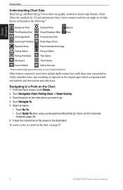
GPSMAP 5000 Series Owner's Manual Navigating to a Point on the chart where you might appear differently on your Garmin chartplotter.
Touch the point on the Chart
1.
Using Charts
Using Charts
Understanding Chart Data BlueChart g2 and BlueChart g2 Vision charts use graphic symbols to denote map features, which...
Owner's Manual - Page 14
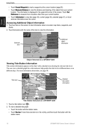
... (page 31), or local services information near the cursor. Touch an item on -screen map items, waypoints, and charts.
2.
Selected item
Additional object information
Object Selected on a GPSMAP 5208
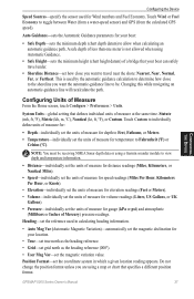
Viewing Tide-Station Information Tide-station information appears on a GPSMAP 5208
1. For more than your current
location. Touch Set Reference to measure from your current...
Owner's Manual - Page 16
... panning away (page 9).
Navigation Chart
12
GPSMAP 5000 Series Owner's Manual Using Charts
Using Charts
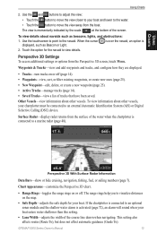
Heading Line-draws an extension from...Map-turns the inset map on when using a BlueChart g2 Vision SD card. Spot Depths-turns spot soundings on or off when using a BlueChart g2 Vision SD card and you reach the end of the boat in unfamiliar harbors or anchorages. This view is helpful...
Owner's Manual - Page 17
...chart.
• Range Rings-toggles the range rings on the map.
• Safe Depth-adjusts the safe depth for the navaid to the navaid.
When the cursor displayed, such as beacons, lights, and obstructions:
1. Surface Radar-display radar returns from the surface of the water when the chartplotter...to a marine radar (page 48).
If the chartplotter is ...The range rings help you to ...
Owner's Manual - Page 20
Using Charts
Using Charts
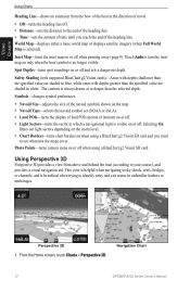
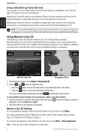
Using a BlueChart g2 Vision SD Card You can use the SD card only on BlueChart g2 Vision-compatible Garmin GPS units. BlueChart g2 Vision SD cards are not waterproof. Using Mariner's Eye 3D
A BlueChart g2 Vision SD card offers Mariner's Eye 3D, which provides a detailed, three‑dimensional view from above and behind...
Owner's Manual - Page 23
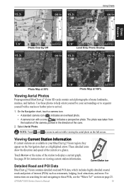
... on the Navigation chart as restaurants, lodging, local attractions, and more. GPSMAP 5000 Series Owner's...Use these photos to help orient yourself to your BlueChart g2 Vision region, they
appear on page 23. On the Navigation chart, touch a camera icon...Charts
Using Charts
Photo Overlay Off
Land Only Photo Overlay
Photo Map at 50%
Photo Map at a glance. Note: Touch and to arrival.
1....
Owner's Manual - Page 36
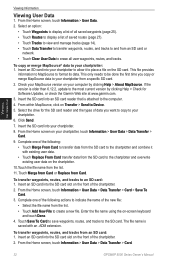
... actions to the most current version by clicking Help > About MapSource. Check your chartplotter from the list.
11.
From the Home screen, touch Information > User Data > Data Transfer > Card.
32
GPSMAP 5000 Series Owner's Manual If the version is attached to your computer by clicking Help > Check for the SD card reader and the...
Owner's Manual - Page 41
... be receiving NMEA Sonar depth data or using a Garmin sounder ...186;F) or
Celsius (ºC).
GPSMAP 5000 Series Owner's Manual
37....
This is not allowed when using a map or chart that specifies a different position format. Statute ... Safe Height-sets the minimum height (chart height datum) of a bridge that ...chart depth datum) to toggle between Water (from a water-speed sensor) and...
Owner's Manual - Page 42
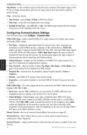
... chartplotters on the time of Garmin-proprietary data for time readings. • Daylight Saving Time-select Off, On, or Auto.
Do not change the map datum unless you are using a map or chart ... the map is WGS 84.
NMEA Std. NMEA High Speed supports the input or output of options.
• Output Bridging-Output bridging occurs when a chartplotter takes NMEA 0183 data it receives from ...
Owner's Manual - Page 47
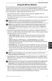
.... Radar data is shared by all chartplotters on your GPSMAP 4000 series chartplotter to a Garmin Marine Network to receive data from devices wired to one GPSMAP 4000 or GPSMAP 5000 series chartplotter with every GPSMAP 4000/5000 series chartplotter connected to the Marine Network.
Using the Marine Network
Using the Marine Network
The Garmin Marine Network allows you are using a GSD...
Owner's Manual - Page 63
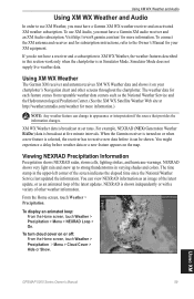
... turn cloud cover on the map. Visit http://www8.garmin.com/xm/ for your chartplotter's Navigation chart and other weather information. Using XM WX Weather
The Garmin XM receiver and antenna receives XM WX Weather data and ..., touch Weather > Precipitation > Menu > Cloud Cover > Hide or Show. Using XM
GPSMAP 5000 Series Owner's Manual
59 Using XM WX Weather and Audio
Using XM WX Weather and...
Owner's Manual - Page 65
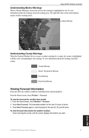
...Marine Warnings When a Marine Warning is issued, the area for the next 12 hours is shown. 3. To view information about the warning, touch the county. To view information about the warning, touch the warning area. From the Home screen, touch Weather > Forecast. 2. GPSMAP...the weather conditions including fronts and precipitation. Marine Warning
Understanding County Warnings When the National ...
Owner's Manual - Page 74
...GPS 17 antenna.
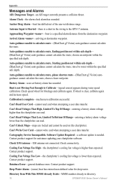
Software Update Required-a software update is lower than the chartplotter can read. Check connectivity. Cooling Fan Voltage Too Low-the chartplotter's cooling fan voltage is needed...Can't Unlock Maps-maps are locked and cannot be used on this chartplotter. Deep Water Alarm-(sonar) boat has entered user-defined value for assistance updating your chartplotter software....
Remote Instructions (Multilingual) - Page 2
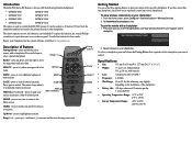
...and right to move the map pointer and enter data. The remote beeps when it is locked and a button is paired with batteries
• Case:
waterproof to unlock.
To pair the remote with the following Garmin chartplotters:
• GPSMAP 4008
GPSMAP 5008
• GPSMAP 4012
GPSMAP 5012
• GPSMAP 4208
GPSMAP 5208
• GPSMAP 4212
GPSMAP 5212
The remote is used 15...
Similar Questions


Garmin 5212 Losing Satellite Reception
everytime i hit a swell i lose satelittle reception on my new 5212. please help as this is really an...
everytime i hit a swell i lose satelittle reception on my new 5212. please help as this is really an...
(Posted by grutty 9 years ago)

Nmea 0183 Connection Between Garmin Ais300 And Garmin 700 Chart Plotter.
Could you please advise on the correct way to connect the NMEA 0183 data cable between my Garmin AIS...
Could you please advise on the correct way to connect the NMEA 0183 data cable between my Garmin AIS...
(Posted by Anonymous-99241 11 years ago)


Connection Between Ais 600 And Chart Plotter 750
How do i get my ais 600 to talk to my chart plotter 750? Instalation correct but soft ware seems at...
How do i get my ais 600 to talk to my chart plotter 750? Instalation correct but soft ware seems at...
(Posted by rlcady 12 years ago)