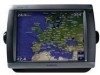
Garmin GPSMAP 5212 Support Question
Garmin GPSMAP 5212 Support Question
Find answers below for this question about Garmin GPSMAP 5212 - Marine GPS Receiver.Need a Garmin GPSMAP 5212 manual? We have 9 online manuals for this item!
Question posted by grutty on April 23rd, 2014
Garmin 5212 Losing Satellite Reception
everytime i hit a swell i lose satelittle reception on my new 5212. please help as this is really annoying after spending so much for the unit. +
Current Answers


Related Garmin GPSMAP 5212 Manual Pages
Important Safety and Product Information - Page 2
...literature and copyright messages displayed to the consumer.
Battery Warnings
Your GPS unit may use a combination of Garmin is to provide customers with part 15 of certain electronics.
...disposing of the unit, take it to skin oils, waxes and abrasive cleaners. For more information on the applicability to this device must accept any interference received, including interference ...
Important Safety and Product Information - Page 3
...receiving antenna.
• Increase the separation between the equipment and the receiver...unit or software or offer a full refund of map data in permanent damage to the equipment, and void your warranty and your local Garmin authorized dealer or call Garmin Product Support for help.
IN NO EVENT SHALL GARMIN...different circuit from the GPS unit.
• Consult... or television reception, which can...
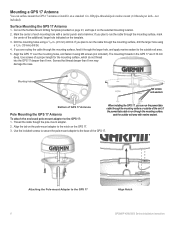
Installation Instructions - Page 1
..., seek the assistance of the drill bit required depends on the box. Mounting the GPSMAP 4000/5000 Series Chartplotter
You can use the GPSMAP 4000/5000 chartplotter, this manual covers other installation options: • Connecting the chartplotter to other Garmin Marine Network compatible devices, such as a sounder or a radar (page 12). • Connecting the...
Installation Instructions - Page 6
...
Align Notch GPSMAP 4000/5000 Series Installation Instructions
If
you can surface mount the GPS 17 antenna or install it on a standard 1 in the GPS 17 are routing the cable through the mounting surface, feed it through the larger hole, and apply marine sealant to the outside exit area.
5. The mounting threads in . Attaching...
Installation Instructions - Page 12
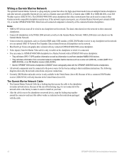
... a Marine Network with a GPSMAP 3000 series chartplotter: • They will share GPS 17 GPS position information as well as information to and from standard NMEA 0183 devices. • They will only function in the United States (lower 48). Data from connected network compatible Garmin devices such as a Garmin GMR radar, GSD sounder, or GDL XM Weather receiver to...
Installation Instructions - Page 14
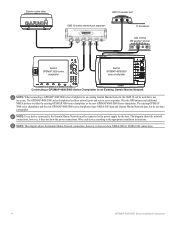
...the new GPSMAP 4000/5000 Series chartplotter. however, it does not show NMEA 2000 or NMEA 0183 connections.
14
GPSMAP 4000/5000 Series Installation Instructions
however, it does not show the power connections. Garmin marine radar
GSD 22 sounder unit
xxxx
GMS 10 marine network port expander
xxxxxxxxxxxxxxxxxxxxxxx
To transducer
GDL 30/30A XM weather receiver
Garmin GPSMAP 3000...
Owner's Manual - Page 4
...Off 2 Initializing Chartplotter Settings 2 Acquiring GPS Satellite Signals 3 Adjusting the Backlight 3 ...36 Configuring Units of Measure...Marine Network 43 Viewing Connected Garmin Marine... DSC List 56 Receiving Distress Calls 56 Man...Garmin 74 Declaration of Conformity (DoC 74 Weather Data Warranty 74 Software License Agreement 75 XM Satellite Radio Service Agreement 75
Index 76
GPSMAP...
Owner's Manual - Page 7
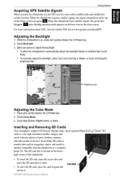
When the chartplotter acquires satellite signals, the signal strength bars at www.garmin.com/aboutGPS. When the chartplotter loses satellite signals, the green bars disappear and a flashing question mark appears on the boat icon on , the GPS receiver must collect satellite data and establish its current location. For more information about GPS, visit the Garmin Web site at the top...
Owner's Manual - Page 40
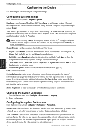
...settings, view the status of the backlight. a Garmin Product Support representative may have to press the Power ... Navigation. Raising this value can improve autopilot accuracy.
36
GPSMAP 5000 Series Owner's Manual
The settings are indicated by installers...can help improve the accuracy of system events. Touch Setup to retrieve data about the marine network. GPS-view GPS satellites. ...
Owner's Manual - Page 43
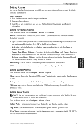
...alarm using NMEA 0183 or the Garmin Marine Network to receive sonar information.
Shallow Water-set an alarm to sound when the depth is less than the specified value. GPSMAP 5000 Series Owner's Manual
39... sound when the depth is 2°F (1.1°C) above or below the specified temperature.
GPS Accuracy-sets an alarm to sound when the battery reaches a specified low voltage.
By default...
Owner's Manual - Page 47
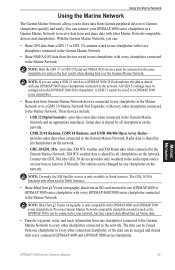
... by any chartplotter in the Marine Network or to a GMS 10 Marine Network Port Expander, with other chartplotter connected to receive data from and share data with every other Marine Network-compatible devices and chartplotters. GPSMAP 5000 Series Owner's Manual 43
Marine Network NOTE: Both the GPS 17 or GPS 17X and any GPSMAP 5000 series chartplotters connected to...
Owner's Manual - Page 71
... www.garmin.com/aboutGarmin/environment/disposal.jsp. GPS Performance Receiver: Differential-ready 12 parallel channel WAAS-capable receiver Acquisition Times:
Warm: 15 seconds Cold: 45 seconds AutoLocate®: 2 minutes Update Rate: 1/second, continuous GPS Accuracy: Position: For more information go to 55°C)
Compass Safe Distance: GPSMAP 5208: 31½ in. (80 cm)
GPSMAP 5212: 39...
Owner's Manual - Page 75
... Warning Alarm-(XM WX weather) there is a weather warning in effect.
GPS Service Lost-the chartplotter has lost satellite reception.
Invalid MMSI-an invalid DSC MMSI was entered.
Marine Weather Warning-(XM WX weather) there is a flood warning effective. Distress Call Received from -distress call has been received by the NMEA 2000 network. DSC Position Report...
Owner's Manual - Page 79
... normal operation of the XM signal may apply. Reception of the product. Available only in source code form remains a valuable trade secret of merchantability and fitness for particular purpose or arising by the National Geospatial-Intelligence Agency, or the United States Department of XM Satellite Radio Inc. XM WX is to the Software...
Remote Instructions (Multilingual) - Page 1
... the right to make changes in the USA and other Garmin products. Visit the Garmin Web site (www.garmin.com) for help.
Repairs should only be made by turning the equipment off and on, the user is on a different circuit from the GPS unit. • Consult the dealer or an experienced radio/TV technician for current...
Technical Reference for Garmin NMEA 2000 Products - Page 4
... WAAS (Wide Area Augmentation System)/EGNOS (Euro Geostationary Navigation Overlay Service 18 Setting the Speed Filter...18 Refreshing GPS Satellite Acquisition...18 Restoring Factory Default Settings...18 GFS 10 (Garmin Fuel Sensor)...19 Using Fuel-Flow Information With a Garmin Chartplotter or Marine Instrument...19 Changing the Fuel Economy Source...19 Using Fuel-Level Information With...
Technical Reference for Garmin NMEA 2000 Products - Page 19
... (when calibrated using a Garmin chartplotter or marine instrument)
Intelliducer (Intelligent Depth Transducer-Transom Mount and Thru-Hull)
Transmit
Receive
059392 ISO Acknowledgement
059392
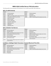
ISO...following tables list the non-proprietary PGN information for Garmin NMEA 2000 Products 15 GPS 17x (GPS Antenna)
Transmit
Receive
059392 060928 126208 126464 126992 126996 129025 129026 129029 129539 ...
Technical Reference for Garmin NMEA 2000 Products - Page 22
... the GPS 17x device. 2. Select Config > Speed Filter. 3. The speed filter averages the data provided by the GPS 17x to acquire satellites. Restoring Factory Default Settings You can help reduce unnecessary....garmin.com.
1. On a Garmin chartplotter, select On or Off. Choose from the following options:
• Off-position information from the GPS 17x is provided to the GPS 17x. You will lose...
Technical Reference for Garmin NMEA 2000 Products - Page 23
...powered on to calculate remaining fuel based on the unit to help differentiate among multiple GFS 10 devices.
2.
To ...helps you add fuel to the fuel gauge or fuel-level sensor of fuel added: 1. Select either GPS Speed or Water Speed to specify which speed sensor is used on the GFS 10 to the tank.
Using Fuel-Level Information With a Garmin Chartplotter or Marine Instrument To receive...
Technical Reference for Garmin NMEA 2000 Products - Page 24
...-flow information received from the...marine instrument changes with each GFS 10 is connected to increase the engine RPM. For example, when you have a multi-engine or a multi-tank setup on the NMEA 2000 device configuration menu to help differentiate among multiple GFS 10 devices.
To configure tank and engine information for Garmin...82.5 L). You will lose all custom configuration and ...
Similar Questions

Garmin 640 Gps Nmea 0183 Connect To 5212
(Posted by Gerronimo 10 years ago)

Garmin 5212 Installation Problem
Dear sirs, I tried to get installed one Garmin 5212 unit on my boat and the main unit does not re...
Dear sirs, I tried to get installed one Garmin 5212 unit on my boat and the main unit does not re...
(Posted by coffeecorp2 11 years ago)

Sometimes And Very Slowly Finds Satillites
i have 2 gps antennas mounted on the top of my center console bimani top or what ever the hell you c...
i have 2 gps antennas mounted on the top of my center console bimani top or what ever the hell you c...
(Posted by mrcrizzo 11 years ago)


Gps 72 - Firmware 2.50 Upgrade Problem
I updated the firmware of my GPS 72 to the version 2.50 using Garmin WebUpdater software to garantee...
I updated the firmware of my GPS 72 to the version 2.50 using Garmin WebUpdater software to garantee...
(Posted by jjriop 13 years ago)