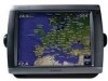
Garmin GPSMAP 5212 Support Question
Garmin GPSMAP 5212 Support Question
Find answers below for this question about Garmin GPSMAP 5212 - Marine GPS Receiver.Need a Garmin GPSMAP 5212 manual? We have 9 online manuals for this item!
Question posted by coffeecorp2 on December 26th, 2012
Garmin 5212 Installation Problem
Dear sirs,
I tried to get installed one Garmin 5212 unit on my boat and the main unit does not recognize the GPS antenna, How can I solve this problem?
The unit will be alone, only installed with the GPS antenna.
Current Answers
Related Garmin GPSMAP 5212 Manual Pages
Installation Instructions - Page 1
... at most marine dealers. Ensure the chartplotter software is on the bail mount are not included.
You can use the included bracket to bail mount the chartplotter, or you must flush mount a GPSMAP 5015/5215 chartplotter.
F
Printed in each section. GPSMAP® 4000/5000 Series Installation Instructions
The GPSMAP 4000/5000 series chartplotter and GPS antenna must...
Installation Instructions - Page 5
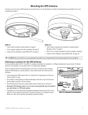
... mounted. Select a suitable location for the antenna included with other electronics, try a different location. When you experience interference with your product box. See page 23.
• Connects to water level. See page 10. OK Radar
3 ft. (1 m) VHF Radio Antenna
GPS 17x Placement Considerations
GPSMAP 4000/5000 Series Installation Instructions
See page 9.
If you verify...
Installation Instructions - Page 9
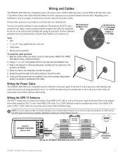
...) and ground (black) wires. Wiring the GPS 17 Antenna
The GPS 17 antenna must be wired to the included 19-pin NMEA 0183 cable as well as to a Garmin Marine Network. Refer to the diagram
below when wiring the GPS 17 to the chartplotter, and test the system.
5. Garmin GPSMAP 4000/5000
Series Unit
Power cable
Wire color
Fuse 7.5 A - 42...
Installation Instructions - Page 10
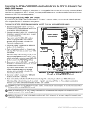
... If your boat already has a NMEA 2000 network installed, use the included T-connectors and drop cable to connect the GPSMAP 4000/5000
series chartplotter and GPS 17x antenna to an existing NMEA 2000 network.
GPSMAP 4000/5000 series chartplotter
GPS 17x antenna
3. Existing NMEA 2000 network (not included)
Connecting the GPSMAP 4000/5000 Series Chartplotter and GPS 17x Antenna to the...
Installation Instructions - Page 11
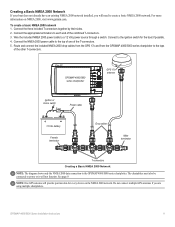
... If your boat does not already have an existing NMEA 2000 network installed, you are using multiple chartplotters. GPSMAP 4000/5000 Series Installation Instructions
11
...garmin.com.
Connect the appropriate terminators to create a basic NMEA 2000 network. Do not connect multiple GPS antennas if you will not function. GPSMAP 4000/5000 series chartplotter
GPS 17x antenna...
Installation Instructions - Page 12
...
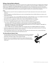
GPSMAP 4000/5000 Series Installation Instructions Notes: • NMEA 0183 devices must all chartplotters to the NMEA 2000 network as well as a Garmin sonar unit (GSD 22), a Garmin radar (GMR 18 or GMR 404/406), or an XM Weather receiver (GDL30/30A). Wiring a Garmin Marine Network
The optional Garmin Marine Network is a plug-and-play system that allows for the boat...
Installation Instructions - Page 14
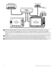
.... Wire the GPS antenna and additional NMEA devices to the power supply for the boat. This diagram shows the network connections; however, it does not show NMEA 2000 or NMEA 0183 connections.
14
GPSMAP 4000/5000 Series Installation Instructions Wire each device according to the appropriate installation instructions.
Note: This diagram shows the Garmin Marine Network connections...
Installation Instructions - Page 19
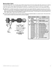
...overall shield
GPSMAP 4000/5000 Series Installation Instructions
19... The remote monitor
must be capable of NTSC (National Television System Committee)/PAL (Phase Alternate Line) composite video sources, and PC monitor output (4008/4208/4010/4210/5008/5208 = VGA output, 4012/4212/5012/5212...Marine Video inputs are attached and will not transmit over the Garmin Marine...
Installation Instructions - Page 20
..., visit www.garmin.com to make sure your chartplotter, select or touch Configure > System > System Information.
20
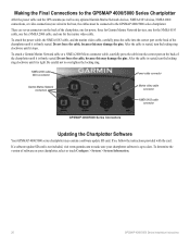
GPSMAP 4000/5000 Series Installation Instructions To attach a Garmin Marine Network cable or...Making the Final Connections to the GPSMAP 4000/5000 Series Chartplotter
After the power cable and the GPS antenna (as well as any optional Garmin Marine Network devices, NMEA 0183 devices...
Owner's Manual - Page 4
... Chartplotter Settings 2 Acquiring GPS Satellite Signals 3 Adjusting ...Mariner...Garmin...Units of Measure 37 Configuring Communications Settings 38 Setting Alarms 39 Setting the Total Fuel Onboard Alarm 40 Configuring My Boat 40
ii
Configuring Other Vessels 41 Configuring XM Audio 42
Using the Marine Network 43 Viewing Connected Garmin Marine...56 Receiving Distress...Garmin 74 Declaration of...
Owner's Manual - Page 15

...Currents-turns the display of marine service points on the map at different zoom levels.
Roses-displays a compass rose around your boat, indicating compass direction. ...resolution satellite images to a compatible marine wind sensor. Detail-adjusts the amount of navigation is only available while using a BlueChart g2 Vision SD card (page 18).
GPSMAP 5000 Series Owner's Manual 11
...
Owner's Manual - Page 75
... has been received by the DSC module. Lost Heading Sensor Connection- (radar/NMEA) the chartplotter has lost satellite reception. Check the network and the antenna wiring.
Drift Alarm-boat has moved a user-defined distance. Contact product support. Flash Flood Warning Alarm-(XM WX weather) there is a flash flood warning in effect. GPS Service Lost...
Technical Reference for Garmin NMEA 2000 Products - Page 4
... Length and Device Limits...8 Existing NMEA 2000 Installation Considerations...8 NMEA 2000 Glossary...8
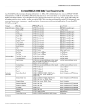
General NMEA 2000 Data Type Requirements...9
NMEA 2000-Certified Display Device PGN Information...13
GPSMAP 4000/5000 Series Chartplotters...13 GMI 10...14
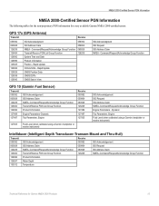
NMEA 2000-Certified Sensor PGN Information...15 GPS 17x (GPS Antenna)...15 GFS 10 (Garmin Fuel Sensor)...15 Intelliducer (Intelligent Depth...
Technical Reference for Garmin NMEA 2000 Products - Page 13
...Garmin Chartplotter and GPS Antenna
Garmin Chartplotter and GPS Antenna
Garmin Chartplotter Garmin Chartplotter and GPS Antenna Garmin Chartplotter and GPS Antenna Garmin Chartplotter and GPS Antenna Garmin Chartplotter and GPS Antenna Heading Sensor GPS Antenna...you have installed and configured. Refer to the following table for Garmin NMEA ...devices (such as a GPSMAP 4000/5000 series chartplotter ...
Technical Reference for Garmin NMEA 2000 Products - Page 14

... • Wind Sensor and a Water Speed
Sensor, and a Heading Sensor
(Continued)
10
Technical Reference for Garmin NMEA 2000 Products COG/SOG and 129029 - GNSS Position, and 129284 - GNSS Position GPS Antenna
129026 - GNSS Position GPS Antenna
128259 - Actual Pressure, 130310 - GNSS Position, 127250 - Wind Data, 129026 - Wind Data, 129026 - COG/SOG and 129029 - Envir Param...
Technical Reference for Garmin NMEA 2000 Products - Page 15

... a Water Speed Sensor is not present, a less accurate reading can be calculated using a GPS antenna instead [129026 - Water Speed (If a Water Speed Sensor is not present, a less accurate reading can be calculated using a GPS antenna instead [129026 - Nav Data
Garmin Chartplotter and GPS Antenna
Maximum Apparent Wind Speed 130306 - Wind Data
Wind Sensor
Maximum True Wind Speed...
Technical Reference for Garmin NMEA 2000 Products - Page 16

...
129026 - GNSS Position
None
None
Typical Sender Depth Transducer Water Temperature Sensor
Water Speed Sensor GPS Antenna, Water Speed Sensor, and Heading Sensor GPS Antenna, Water Speed Sensor, and Heading Sensor GPS Antenna GPS Antenna None None
12
Technical Reference for Garmin NMEA 2000 Products COG/SOG, 129029 - GNSS Position, 128259 - GNSS Position
129026 - GNSS Position, 128259...
Technical Reference for Garmin NMEA 2000 Products - Page 19
...Depth
130312 Temperature
Technical Reference for every available Garmin NMEA 2000-certified sensor. GPS 17x (GPS Antenna)
Transmit
Receive
059392 060928 126208 126464 126992 126996 129025 ... Transmit/Receive PGN List Group Function System Time and Date Product Information Position - Dynamic
Trip Parameters, Engine Fluid Level (when calibrated using a Garmin chartplotter or marine instrument...
Technical Reference for Garmin NMEA 2000 Products - Page 22
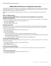
... Sensor Configuration Information
Garmin NMEA 2000-certified sensors each have moved the boat many miles without using the GPS 17x, for example, you can force the GPS 17x to re-...updates. Select Config > Factory Defaults.
18
Technical Reference for every available Garmin NMEA 2000 sensors. GPS 17x (GPS Antenna)
Enabling and Disabling WAAS (Wide Area Augmentation System)/EGNOS (Euro Geostationary...
Technical Reference for Garmin NMEA 2000 Products - Page 23
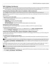
... Important: When using the GFS 10 to calculate remaining fuel based on the unit to all available fuel-level instruments and sources. While viewing the fuel page ...Using Fuel-Level Information With a Garmin Chartplotter or Marine Instrument To receive fuel-level information, connect the wiring harness on your boat according to the GFS 10 Installation Instructions. Select Config > Level Calibration...
Similar Questions

How Do I Go Into Simulation Mode On A Garmin Marine Gps Modle741xs
how do I use simulation mode on a garmin 741xs marine ver
how do I use simulation mode on a garmin 741xs marine ver
(Posted by Curthupp 6 years ago)

Garmin 640 Gps Nmea 0183 Connect To 5212
(Posted by Gerronimo 10 years ago)

I Forgot To Lower My Antenna For Gps Units And The Tops Were Torn Off. Help!
I have a basic GPS and a 5212 unit and both antenna were damaged by low haing branches. The tops wer...
I have a basic GPS and a 5212 unit and both antenna were damaged by low haing branches. The tops wer...
(Posted by DrG5159 10 years ago)

Internal Memory Capacity Gpsmap 620 Question
Dear Sir, I already am a user of 2 garmin GPS and I am extreemly satisfied with. I plan to purchas...
Dear Sir, I already am a user of 2 garmin GPS and I am extreemly satisfied with. I plan to purchas...
(Posted by altes 12 years ago)
