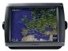
Garmin GPSMAP 5212 Support Question
Garmin GPSMAP 5212 Support Question
Find answers below for this question about Garmin GPSMAP 5212 - Marine GPS Receiver.Need a Garmin GPSMAP 5212 manual? We have 9 online manuals for this item!
Question posted by chasman87 on January 30th, 2012
Garmin 5212
How do i unlock the maps on my Garmin 5212
Current Answers
Related Garmin GPSMAP 5212 Manual Pages
Declaration of Conformity - Page 1
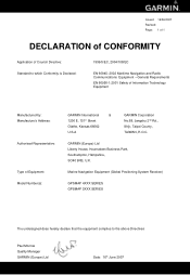
Marine Navigation Equipment (Global Positioning System Receiver)
GPSMAP 4XXX SERIES GPSMAP 5XXX SERIES
The undersigned does hereby declare that the equipment complies to which Conformity is Declared:
1999/5/EC, 2004/108/EC
EN 60945: 2002 Maritime Navigation and Radio Communications Equipment - GARMIN (Europe) Ltd Liberty House, Hounsdown Business Park, Southampton, Hampshire, SO40 9RB, ...
Installation Instructions - Page 1
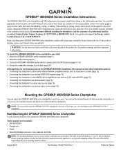
... section. August 2009
Part Number 190-00779-02 Rev. Mount the GPSMAP 4000/5000 series chartplotter in diameter. or contact Garmin Product Support by phone at most marine dealers.
WARNING: See the Important Safety and Product Information guide in Taiwan Mount the GPS antenna (page 5). 3. F
Printed in the product box for product warnings and...
Installation Instructions - Page 5
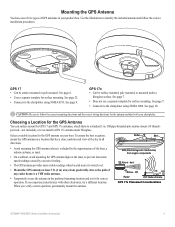
...See page 10. OD pipe-threaded-pole marine mount (14 threads- per-inch-not included), or even install a GPS 17x antenna under a
fiberglass surface. EMI
... separate template for surface mounting.
OK Radar
3 ft. (1 m) VHF Radio Antenna
GPS 17x Placement Considerations
GPSMAP 4000/5000 Series Installation Instructions
See page 6.
• Uses a separate template for surface mounting.
...
Installation Instructions - Page 6
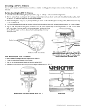
...drill
bit. OD pipe-threaded-pole marine mount (14 threads per inch-not
included).
If you can surface mount the GPS 17 antenna or install it through the larger hole, and apply marine sealant to the outside exit area....
Align the GPS 17 over the mounting holes, and fasten it on the GPS 17.
3. To attach the enclosed pole-mount adapter to the GPS 17
Align Notch GPSMAP 4000/5000 Series...
Installation Instructions - Page 9
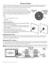
... use specialized Garmin Network cables. Garmin rubber grommets are using more than one chartplotter to weatherproof the cable. Apply a marine sealant around the cable.
6. Apply marine sealant, as needed , to a GPS antenna.
Use this line for a finished look. Use 14 AWG shielded wiring for trimming instructions. The GPS signal is seated. Wiring and Cables
The GPSMAP 4000...
Installation Instructions - Page 12
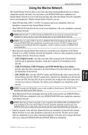
...; They will share GPS 17 GPS position information as well as a sonar unit (GSD 22), a radar (GMR 18 or GMR 404/406), or an XM Weather receiver (GDL30/30A). • Garmin GPSMAP 3000 series chartplotters CANNOT share cartography data with the cable.
12
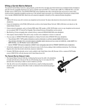
GPSMAP 4000/5000 Series Installation Instructions Wiring a Garmin Marine Network
The optional Garmin Marine Network is a plug...
Installation Instructions - Page 14
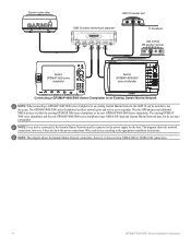
... port expander
xxxxxxxxxxxxxxxxxxxxxxx
To transducer
GDL 30/30A XM weather receiver
Garmin GPSMAP 3000 series
chartplotter
Garmin GPSMAP 4000/5000
series chartplotter
Connecting a GPSMAP 4000/5000 Series Chartplotter to an Existing Garmin Marine Network
Note: When connecting a GPSMAP 4000/5000 series chartplotter to an existing Garmin Marine Network, the GMS 10 can be connected to the power...
Installation Instructions - Page 20
... cable is seated, turn the locking ring clockwise until it stops.
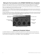
Making the Final Connections to the GPSMAP 4000/5000 Series Chartplotter
After the power cable and the GPS antenna (as well as any optional Garmin Marine Network devices, NMEA 0183 devices, NMEA 2000 connections, or video connections) are seven connectors on the back...
Owner's Manual - Page 4
...the Chartplotter Off 2 Initializing Chartplotter Settings 2 Acquiring GPS Satellite Signals 3 Adjusting the Backlight 3 Adjusting the...g2 Vision 15 Using Mariner's Eye 3D 16 ... 27 Navigating with a Garmin Autopilot 29
Viewing Information ... the Marine Network 43 Viewing Connected Garmin Marine Network ...Viewing the DSC List 56 Receiving Distress Calls 56 Man-Overboard ... Garmin 74 Declaration of ...
Owner's Manual - Page 20
....
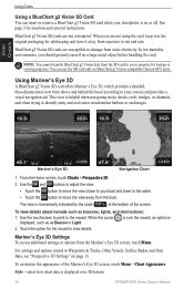
• Touch the button to your chartplotter is on BlueChart g2 Vision-compatible Garmin GPS units. Mariner's Eye 3D
Navigation Chart
1. Use the and buttons to adjust the view:
•...terrain.
16
GPSMAP 5000 Series Owner's Manual This view is momentarily indicated by the scale (
) at the bottom of the Mariner's Eye 3D screen, touch Menu > Chart Appearance. Mariner's Eye 3D...
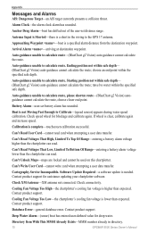
Owner's Manual - Page 40
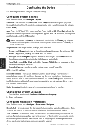
... (GPSMAP 5215 only)-turn the screenshot capture feature on ambient light.
• Color Mode-touch Color Mode to select Day Colors or Night Colors, or touch Auto to allow the chartplotter to set Simulator options. (If you transition to retrieve data about the marine network. The Save to view additional information. a Garmin Product...
Owner's Manual - Page 43
...Garmin Marine Network to arrival.
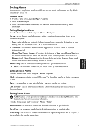
• Change Time/Change Distance-if you exceed a specified drift distance. GPS... Accuracy-sets an alarm to sound when the battery reaches a specified low voltage.
Water Temp-sets an alarm to sound when the transducer reports a temperature that is less than the specified value.
GPSMAP...the alarm on distance to receive sonar information.
To set the...
Owner's Manual - Page 47
... the network. NOTE: Currently, the XM Satellite service is only compatible with GPSMAP 4000 and GPSMAP 5000 series chartplotters.
NOTE: If you can:
• Share GPS data from a GPS 17 or GPS 17x antenna wired to one chartplotter with every chartplotter connected to the Garmin Marine Network.
• Share NMEA 0183 data from devices wired to one...
Owner's Manual - Page 55
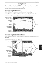
... and water speed
Zoomed depth scale
GPS speed and GPS heading
Zoom level Transducer
frequency
Sonar Split Zoom
Zoom window
Range
Using Sonar
GPSMAP 5000 Series Owner's Manual
51 Understanding ...screen shows the depth of the transducer's sonar readings.
The GSD 22 connects through the Garmin Marine Network and shares sonar data with every chartplotter connected to view a full-screen graph ...
Owner's Manual - Page 71
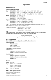
...go to IEC 529-IPX-7
Temp. GPS Performance Receiver: Differential-ready 12 parallel channel WAAS-capable receiver Acquisition Times:
Warm: 15 seconds Cold: 45 seconds AutoLocate®: 2 minutes Update Rate: 1/second, continuous GPS Accuracy: Position: H × 13 in . H × 10⅛ in . W × 5⅝ in . W (128.2 × 170.9 mm)
GPSMAP 5212: 7⅛ in . H × 12 in...
Owner's Manual - Page 74
... Already Exists-MMSI number already in the wiring to the GPS 17 antenna. Approaching Waypoint -boat is a short in directory.
70
GPSMAP 5000 Series Owner's Manual Auto-guidance unable to calculate route-(BlueChart g2 Vision) auto-guidance cannot calculate the route.
Can't Unlock Maps-maps are locked and cannot be used on this chartplotter. Cartography...
Owner's Manual - Page 75
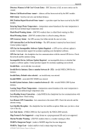
...GPS Service Incompatible.
Enter a number between (0 - 15)-invalid NMEA 2000 System instance. Invalid MMSI-an invalid DSC MMSI was entered.
Low Fuel Alarm-(NMEA 2000) low fuel reported by the DSC module. Map Format Is Not Supported-a map format on a preprogrammed SD card is inside the user-defined target temperature zone. GPSMAP... view of the sky.
Marine Weather Warning-(XM WX weather...
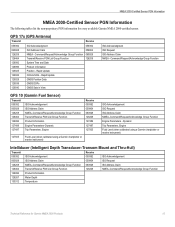
Technical Reference for Garmin NMEA 2000 Products - Page 4
... Display Device PGN Information...13
GPSMAP 4000/5000 Series Chartplotters...13 GMI 10...14
NMEA 2000-Certified Sensor PGN Information...15 GPS 17x (GPS Antenna)...15 GFS 10 (Garmin Fuel Sensor)...15 Intelliducer (Intelligent Depth Transducer-Transom Mount and Thru-Hull)...15 GWS 10 (Garmin Wind Sensor)...16 GHP 10 (Marine Autopilot System)...16
CCU...16...
Technical Reference for Garmin NMEA 2000 Products - Page 19
... and Date Product Information Position - Dynamic
Trip Parameters, Engine Fluid Level (when calibrated using a Garmin chartplotter or marine instrument)
ISO Acknowledgement ISO Request ISO Address Claim NMEA-Command/Request/Acknowledge Group Function Engine Parameters - GPS 17x (GPS Antenna)
Transmit
Receive
059392 060928 126208 126464 126992 126996 129025 129026 129029 129539 129540
ISO...
Technical Reference for Garmin NMEA 2000 Products - Page 23
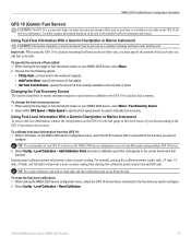
... screen to calculate fuel economy. Using Fuel-Level Information With a Garmin Chartplotter or Marine Instrument To receive fuel-level information, connect the wiring harness on the GFS 10 ...Config > Level Calibration > Reset Calibration. Technical Reference for fuel-level information.
Select either GPS Speed or Water Speed to specify which speed sensor is shown on the fuel-flow rate...
Similar Questions

How Do I Go Into Simulation Mode On A Garmin Marine Gps Modle741xs
how do I use simulation mode on a garmin 741xs marine ver
how do I use simulation mode on a garmin 741xs marine ver
(Posted by Curthupp 6 years ago)

Which Camera Is Controlled With Gpsmap 5212
(Posted by sofory 9 years ago)

Garmin 640 Gps Nmea 0183 Connect To 5212
(Posted by Gerronimo 10 years ago)

541s Marine Gps. Depth Not Reading Out.
Depth has been working since installed. Now blank. Is there an on off control for this that may have...
Depth has been working since installed. Now blank. Is there an on off control for this that may have...
(Posted by therad50 11 years ago)

Garmin 5212 Installation Problem
Dear sirs, I tried to get installed one Garmin 5212 unit on my boat and the main unit does not re...
Dear sirs, I tried to get installed one Garmin 5212 unit on my boat and the main unit does not re...
(Posted by coffeecorp2 11 years ago)