Garmin GPSMAP 5212 Support Question
Garmin GPSMAP 5212 Support Question
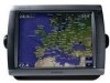
Find answers below for this question about Garmin GPSMAP 5212 - Marine GPS Receiver.Need a Garmin GPSMAP 5212 manual? We have 9 online manuals for this item!
Question posted by homeofthebrave4 on August 26th, 2013
My 5212 Compass Heading (and Boat Icon) Are About 40 Degrees Off.
The person who posted this question about this Garmin product did not include a detailed explanation. Please use the "Request More Information" button to the right if more details would help you to answer this question.
Current Answers
Related Garmin GPSMAP 5212 Manual Pages
Installation Instructions - Page 2
... of the four mounting holes. Be sure to the surface with your mounting hardware. 3. NOTE: Mount a GPSMAP 4008/4208/5008/5208 chartplotter 31 1/2 in. (80 cm), and a GPSMAP 4010/4210/4012/4212/5012/5212 chartplotter 39 3/8 in. (1 m) from a magnetic compass to the GPSMAP 4000/5000 series chartplotter. 2. Loosely attach the mounting knobs to avoid interference. 2.
Installation Instructions - Page 3
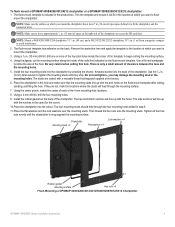
... hole. Note: Make sure to leave approximately 1/2 in . (1 m) from a magnetic compass to fit the chartplotter and the connected wires. If they stop. Chartplotter Mounting studs ×...GPSMAP 4008/4208/4012/4212/5008/5208/5012/5212 Chartplotter
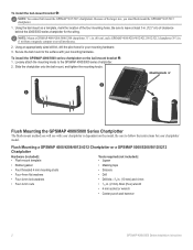
GPSMAP 4000/5000 Series Installation Instructions
To flush mount a GPSMAP 4008/4208/4012/4212 chartplotter or a GPSMAP 5008/5208/5012/5212 ...
Owner's Manual - Page 4
... the Chartplotter Off 2 Initializing Chartplotter Settings 2 Acquiring GPS Satellite Signals 3 Adjusting the Backlight 3 Adjusting the ...40 Configuring My Boat 40
ii
Configuring Other Vessels 41 Configuring XM Audio 42
Using the Marine Network 43 Viewing Connected Garmin Marine...55 Viewing the DSC List 56 Receiving Distress Calls 56 Man-Overboard Distress...GPSMAP 5000 Series Owner's Manual
Owner's Manual - Page 7
... compatible Garmin chartplotter or a computer (page 32).
Card label
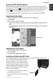
GPSMAP 5000 Series Owner's Manual For more information about GPS, visit the Garmin Web site at the top of the Home...a flashing question mark appears on the boat icon on , press and quickly release the Power key. 2.
While the chartplotter is located on , the GPS receiver must collect satellite data and establish its...
Owner's Manual - Page 13
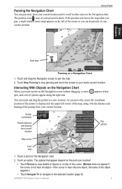
...icon leaves the map when you pan, a small window (inset map) appears on a Navigation Chart
1. Using Charts
Inset map
Panning on the left corner of the map, along the right side. Touch Stop Panning to stop panning and return the screen to your present location. appears at your boat... so you can keep track of your current position. GPSMAP 5000 Series Owner's Manual
As you move the ...
Owner's Manual - Page 15

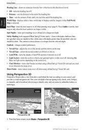
... north heading. • Head Up-sets the map display to the current track heading. • Course Up-sets the map so the direction of marine service points on or off . GPSMAP 5000 ... a BlueChart g2 Vision SD card (page 18). Roses-displays a compass rose around your boat, indicating compass direction.
The heading line appears
vertically on the map at different zoom levels. Photos-sets...
Owner's Manual - Page 16
... POIs-turns the display of land POIs (points of the heading line.
Navigation Chart
12
GPSMAP 5000 Series Owner's Manual
Photo Points-turns camera icons on or off when using a BlueChart g2 Vision SD card... in white. Perspective 3D 1.
Inset Map-turns the inset map on only when the boat symbol is beneficial when trying to see what area the maps cover.
Safety Shading (with...
Owner's Manual - Page 24

Using Charts
Using Automatic Guidance
Automatic Guidance automatically creates and suggests passage based on setting up Automatic Guidance for your boat. See page 28 to use Automatic Guidance.�
Using Charts
20
GPSMAP 5000 Series Owner's Manual See page 40 for instructions on available BlueChart g2 Vision chart information.
Owner's Manual - Page 38
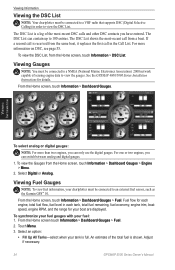
...boat. Viewing Information
To select analog or digital gauges:
Note: For more information on DSC, see page 55. Touch Menu. 3.
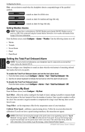
See the GPSMAP 4000/5000 Series Installation Instructions for your chartplotter must be connected to a NMEA (National Marine... To view fuel information, your boat are displayed.
The DSC List is a log of the total fuel is received from the Home screen, touch ...
Owner's Manual - Page 39
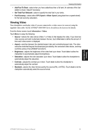
...8226; Add Fuel To Boat-select when you have...used by the connected video device, and may not fill the entire of the GPSMAP 5212/5215.
• Brightness-adjusts the brightness of time each video screen is ... Fuel Economy-select either GPS Speed or Water Speed (using the supplied video cable. Viewing Information
GPSMAP 5000 Series Owner's Manual
35 See the GPSMAP 4000/5000 Series Installation...
Owner's Manual - Page 41
... your boat can safely travel under.
• Shoreline Distance-set how close to the shoreline you want the automatic-guidance line to be receiving NMEA Sonar...and GPS (from the calculated GPS speed). Statute (mh, ft, ºF), Metric (kh, m, ºC), Nautical (kt, ft, ºF), or Custom. Position Format-set the coordinate system in calculating heading ...GPSMAP 5000 Series Owner's Manual
37
Owner's Manual - Page 44
... the on or off:
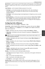
• Marine • Tornado • Severe Storm • Flood • Flash Flood
Setting the Total Fuel Onboard Alarm
Note: To receive fuel-level information, your chartplotter must...and safely increase boat speed. Use the on-screen keyboard to offset for medium and large fish only. If you get the message, contact Garmin Product Support.
40
GPSMAP 5000 Series Owner's...
Owner's Manual - Page 50
.... From the Radar screen, touch Menu > Sentry Setup. 2. Using Radar
46
GPSMAP 5000 Series Owner's Manual Using Radar
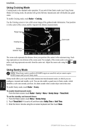
Using Cruising Mode
Cruising mode is set to ...to off, and then select Stdby Time or Xmit Time. 3. Range rings
Heading line
Zoom scale
Distance between rings
The zoom scale represents the distance from Sentry...boat. To enable Sentry mode, touch Radar > Sentry.
Owner's Manual - Page 54
...Enter your location that AIS vessels are displayed on the Radar screen.
Using Radar
50
GPSMAP 5000 Series Owner's Manual Using Radar
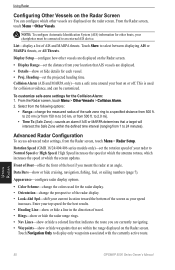
Configuring Other Vessels on the Radar Screen
You can ...
Select from your top speed for the best results. • Heading Line-show or hide a line in the direction of the boat if you are currently navigating. • Waypoints-show or hide ...
Owner's Manual - Page 60
..., your chartplotter alerts you receive a DSC distress call: 1.
When you when your VHF radio receives a DSC distress call.
If a second call is received from the following options:...The DSC list can contain up an individual routine call with the call from a boat. From a chart screen, touch Menu > Other Vessels > DSC List. Man-Overboard...DSC
56
GPSMAP 5000 Series Owner's Manual
Owner's Manual - Page 71
...-capable receiver Acquisition Times:
Warm: 15 seconds Cold: 45 seconds AutoLocate®: 2 minutes Update Rate: 1/second, continuous GPS Accuracy: Position: D (240.5 × 330 × 119.2 mm)
GPSMAP 5215: 11⅝ in . H × 15½ in . H × 12 in . For more information go to 55°C)
Compass Safe Distance: GPSMAP 5208: 31½ in. (80 cm)
GPSMAP 5212...
Owner's Manual - Page 73
... network and to see a list of supported NMEA 2000 PGN numbers, see the GPSMAP 4000/5000 Series Installation Instructions. All GPSMAP 5000 series units are NMEA 2000 certified, and can receive data from up to four NMEA 0183-compliant devices and send GPS data to up to optional NMEA 0183-compliant devices, see the...
Owner's Manual - Page 75
... has been received by the NMEA 2000 network.
Enter a number between (0 - 15)-invalid NMEA 2000 System instance.
Lost Heading Sensor Connection- (radar/NMEA) the chartplotter has lost communications with the heading sensor. Low Fuel Alarm-(NMEA 2000) low fuel reported by the DSC module.
GPS Antenna Has Lost Its Stored Settings-The GPS antenna's memory...
Owner's Manual - Page 80
...54
gauges 34 fuel 34
go to 23 GPS 36
performance 67 grid north 37 guide to 23
H
hazard colors 17 heading 37 Heading Line 12 heading line 12
cruising screen 50 Head Up 11 high pressure center 62 home screen... 32 marine network 43 Mariner's Eye
3D 16 mariner's eye 6 mariner's eye 3D
colors 17 MARPA 48 measure
units 37 measure distance 10 messages 70 MOB 25 moon phase 31 moon rise/set 31 my boat 40
N
...
Technical Reference for Garmin NMEA 2000 Products - Page 26

... information, select Config > Wind Angle Offset. 2. For example, 90 degrees is on the starboard side of the boat, and 270 degrees is not filtered. • On-select a lower number to update...1. Tip: The angles are configured clockwise around the mast of software loaded on your Garmin marine instrument, the specific configuration options may not be displayed on the port side. While viewing ...
Similar Questions

How Do I Go Into Simulation Mode On A Garmin Marine Gps Modle741xs
how do I use simulation mode on a garmin 741xs marine ver
how do I use simulation mode on a garmin 741xs marine ver
(Posted by Curthupp 6 years ago)

441s Garmin Manual. Compass Appears To Show Wrong Heading Is It Nessary To Progr
(Posted by wm7845 9 years ago)

Garmin 5212 Losing Satellite Reception
everytime i hit a swell i lose satelittle reception on my new 5212. please help as this is really an...
everytime i hit a swell i lose satelittle reception on my new 5212. please help as this is really an...
(Posted by grutty 10 years ago)

Garmin 5212 Installation Problem
Dear sirs, I tried to get installed one Garmin 5212 unit on my boat and the main unit does not re...
Dear sirs, I tried to get installed one Garmin 5212 unit on my boat and the main unit does not re...
(Posted by coffeecorp2 11 years ago)
