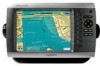
Garmin GPSMAP 4208 Support Question
Garmin GPSMAP 4208 Support Question
Find answers below for this question about Garmin GPSMAP 4208 - Marine GPS Receiver.Need a Garmin GPSMAP 4208 manual? We have 8 online manuals for this item!
Question posted by csmlrankin on July 9th, 2011
Gsb-22 Blinking Green Light
The light is blinking on and off green, the depth reading is flashing on and off on a fixed reading. It may pick up another depth and flash that for a while. Sometimes it flashes 0.0 depth.
Current Answers
Related Garmin GPSMAP 4208 Manual Pages
Declaration of Conformity - Page 1
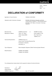
Marine Navigation Equipment (Global Positioning System Receiver)
GPSMAP 4XXX SERIES GPSMAP 5XXX SERIES
The undersigned does hereby declare that the equipment complies to which Conformity is Declared:
1999/5/EC, 2004/108/EC
EN 60945: 2002 Maritime ...
Important Safety and Product Information - Page 2
... the following two conditions: (1) this device may damage plastic components.
Battery Warnings
Your GPS unit may use a combination of governmental and private data sources, which we identify in... Industry Canada Standard RSS-210. Operation is to this device must accept any interference received, including interference that may not cause harmful interference, and (2) this product, see www...
Installation Instructions - Page 9
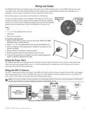
...Marine Network, or
GPS 17 cable. Use 22 AWG shielded wiring for the Marine Video
waterproof seal. Optional Garmin Marine Network components use specialized Garmin Network cables. cable. Tools
• Drill
• 1 1/4 in ) >
White (data out)
>
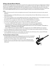
Wiring the GPSMAP 4000/5000 Unit and the GPS 17
>
GPS 17 GPS/WAAS
Sensor
GPSMAP... The GPS signal is seated. on)
> Green (Data out)
GREEN/white...
Installation Instructions - Page 12
...-compatible Garmin devices such as a sonar unit (GSD 22), a radar (GMR 18 or GMR 404/406), or an XM Weather receiver (GDL30/30A). • Garmin GPSMAP 3000 series chartplotters CANNOT share cartography data with any chartplotter on the network.
Wiring a Garmin Marine Network
The optional Garmin Marine Network is a plug-and-play system that allows...
Installation Instructions - Page 14
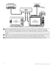
... Series chartplotter. Note: This diagram shows the Garmin Marine Network connections; Garmin marine radar
GSD 22 sounder unit
xxxx
GMS 10 marine network port expander
xxxxxxxxxxxxxxxxxxxxxxx
To transducer
GDL 30/30A XM weather receiver
Garmin GPSMAP 3000 series
chartplotter
Garmin GPSMAP 4000/5000
series chartplotter
Connecting a GPSMAP 4000/5000 Series Chartplotter to an Existing Garmin...
Installation Instructions - Page 16
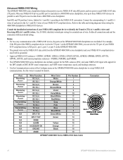
.../White
Gray Pink Blue Blue/White Green/White Green
Yellow Orange Black
Pin Number 1 ...; The GPSMAP 4000/5000 series chartplotter also includes support for the DPT (depth) or ... to three NMEA 0183 devices in
GPS 17 out spare Alarm
Accessory on the GPSMAP 4000/5000 chartplotters are not linked. Port Receiving
Port 1
Receiving Port 2
Receiving Port 3
Receiving Port 4
Transmitting Port 1
Transmitting...
Technical Reference for Garmin NMEA 2000 Products - Page 4
...13
GPSMAP 4000/5000 Series Chartplotters...13 GMI 10...14
NMEA 2000-Certified Sensor PGN Information...15 GPS 17x (GPS Antenna)...15 GFS 10 (Garmin Fuel Sensor)...15 Intelliducer (Intelligent Depth ... With a Garmin Chartplotter or Marine Instrument...19 Changing the Fuel Economy Source...19 Using Fuel-Level Information With a Garmin Chartplotter or Marine Instrument...19 Configuring Engine and Tank...
Technical Reference for Garmin NMEA 2000 Products - Page 19
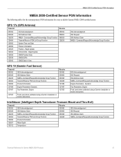
... 059392 059904 060928 126208 127489 127497 127505
127505
Fluid Level (when calibrated using a Garmin chartplotter or marine instrument)
Intelliducer (Intelligent Depth Transducer-Transom Mount and Thru-Hull)
Transmit
Receive
059392 ISO Acknowledgement
059392
ISO Acknowledgement
060928 ISO Address Claim
059904
ISO Request
126208 NMEA-Command/Request/Acknowledge Group Function 060928...
Technical Reference for Garmin NMEA 2000 Products - Page 23
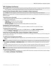
... receive fuel-level information, connect the wiring harness on your boat;
Using Fuel-Flow Information With a Garmin Chartplotter or Marine Instrument
Caution: The Garmin chartplotter or marine instrument must specify the amount of fuel added: 1. For example, entering five calibration points (empty tank, 1/4 tank, 1/2 tank, 3/4 tank, and full tank) will provide a more -accurate reading...
Technical Reference for Garmin NMEA 2000 Products - Page 24
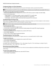
...reading on your boat, specify which engine or tank is associated with each GFS 10 is not moving . To test the gauge-type setting: 1.
Troubleshooting the Fuel-Flow Rate If the fuel-flow information received...Use the throttle to a reading of 22 gal./hr. (82.5 L/h), because 20 gal. × 110% = 22 gal. (75 L ×...setup on your Garmin chartplotter or marine instrument changes with the engine RPM...
Owner's Manual - Page 4
... the Chartplotter 2 Initializing Chartplotter Settings 2 Acquiring GPS Satellite Signals 3 Adjusting the Backlight 3 Adjusting...13 Using BlueChart g2 Vision 15 Using Mariner's Eye 3D 16 Using Fish Eye... Screen 21 Editing the Combinations Screen 22
Where To 23 Navigating to a... 54 Viewing the DSC List 55 Receiving Distress Calls 55 Man-Overboard Distress Calls...GPSMAP 4000 Series Owner's Manual
Owner's Manual - Page 7
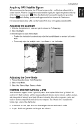
...on the chartplotter, the GPS receiver must collect satellite data...GPS Satellite Signals
When you turn on ambient light, select Auto.
• To manually adjust the backlight, select Up or Down, or use the Rocker. When the chartplotter loses satellite signals, the green bars disappear and a flashing... the Home screen are green . Adjusting the Color ...For more information about GPS, visit the Garmin ...
Owner's Manual - Page 21

... mapping. Sonar Cone-turns a cone on or off . GPSMAP 4000 Series Owner's Manual 17
Data Bars-shows or hides ... Mariner's Eye 3D, Hazard Colors Off
Mariner's Eye 3D, Hazard Colors On
For settings and options related to Range Rings, Safe Depth, ...indicated by your transducer.
Sonar Data-shows the sonar readings received by red, green, and yellow spheres. The On setting indicates shallow ...
Owner's Manual - Page 39
...GPS satellites.
Speed Sources-specify the sensor used by waypoint name, or whether the description of the backlight.
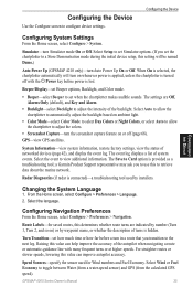
Configuring the Device
Use the Configure screen to view additional information. Select Auto to allow the chartplotter to automatically adjust the backlight based on ambient light... to retrieve data about the marine network. GPSMAP 4000 Series Owner's Manual
35
Owner's Manual - Page 42
.... 4.
Clock-sets an alarm using the Garmin Marine Network to receive sonar information.
Configuring the Device
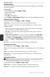
Setting Alarms
You can set an alarm to sound when you are within a specified distance or time from a turn the alarm on 5. Use the Rocker or Numeric Keypad (GPSMAP 4210 or 4212 only) to change the time...
Owner's Manual - Page 46
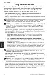
... 404/406 Open Array Radar- NOTE: BlueChart g2 Vision cartography is shared with every chartplotter connected to the Marine Network.
The station can be connected to your GPSMAP 4000 series chartplotter to a Garmin Marine Network to receive data from an SD card inserted in North America.
• Share BlueChart g2 Vision cartography data from...
Owner's Manual - Page 47
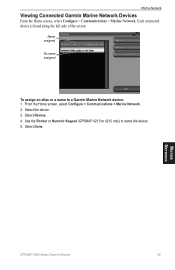
Select Done. Select the device. 3. Select Review. 4.
Each connected device is listed along the left side of the screen. Marine Network
GPSMAP 4000 Series Owner's Manual
43 From the Home screen, select Configure > Communications > Marine Network. 2. Name assigned
No name assigned
To assign an alias or a name to name the device. 5. Use the Rocker...
Owner's Manual - Page 54
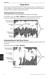
...depth of the transducer's sonar readings. From the Home screen, select Sonar > Full Screen. Depth, temperature, and water speed
Zoomed depth scale
GPS speed and GPS heading
Zoom level
Zoom window
Range
Transducer frequency
Using Sonar
50
GPSMAP 4000 Series Owner's Manual
Depth...Sonar
When connected to an optional Garmin GSD 22 sounder and a transducer, your chartplotter can be used as ...
Owner's Manual - Page 74
... SD card is needed.
Software Update Required-a GPS service software update is not supported. Lost Remote GPS Connection-lost satellite reception. Low Fuel Alarm-(NMEA 2000) low fuel reported by the DSC module. Distress Call Received from -distress call has been received by the DSC module. Flash Flood Warning Alarm-(XM WX weather) there is...
Owner's Manual - Page 79
..., 17 delete all 32 delete a waypoint 26, 32 depth 36 depth line 52 detail 11 device list 37 DSC 40, 54... 53 gauges 33
fuel 33 go to 23 GPS satellite signals 3, 35 grid north 36 guide to...light sectors 11 limited warranty 74 look-ahd spd 49 low pressure center 61
M
man overboard 25 map datum 36 marine network 42 mariner's eye 6 mariner's eye 3D 16
colors 17 marine...GPSMAP 4000 Series Owner's Manual 75
Similar Questions

Depth Gauge Light Blinks, Depth Reading Is Not Accurate
depth gauge light blinks, depth reading is not accurate
depth gauge light blinks, depth reading is not accurate
(Posted by jshunter 5 years ago)

How Do I Go Into Simulation Mode On A Garmin Marine Gps Modle741xs
how do I use simulation mode on a garmin 741xs marine ver
how do I use simulation mode on a garmin 741xs marine ver
(Posted by Curthupp 6 years ago)

No Depth Readings On Gpsmap546s
Have cleaned pins on data cable, transducer, both hot wire and ground connection on data cable. Boug...
Have cleaned pins on data cable, transducer, both hot wire and ground connection on data cable. Boug...
(Posted by sue1953bc 7 years ago)

Whats The Difference Between A Garmin Gpsmap 4208 And Gps Map 4208 Plotter
(Posted by redilui 9 years ago)

Remote Information Monitoring At 22' Display From A Garmin 526s
I need to do a remote monitoring at 22" vga monitor with register of the infortation from garmin 526...
I need to do a remote monitoring at 22" vga monitor with register of the infortation from garmin 526...
(Posted by alvarofmendonca 12 years ago)