User Guide
Page 4
...15 Software updates 16 Settings 16 Access codes 16 Prolong battery life 17 Free memory 18 Your device 19 Antenna locations 19 Welcome 19 Nokia Switch 20 Display indicators 21 Shortcuts 22 Lock the keypad 23 Navi™ wheel 23 Multimedia menu 24 Mobile search 25 Games 25 ... tones in Profiles 29 3-D tones 30 Modify the standby mode 30 Modify the main menu 31 Positioning (GPS 32 About GPS 32 Assisted GPS (A-GPS 32 Hold your device correctly 33 Tips on creating a GPS connection 33 Position requests 34 Landmarks 34 GPS data 34 Maps 37 About Maps 37 Browse maps 38
...15 Software updates 16 Settings 16 Access codes 16 Prolong battery life 17 Free memory 18 Your device 19 Antenna locations 19 Welcome 19 Nokia Switch 20 Display indicators 21 Shortcuts 22 Lock the keypad 23 Navi™ wheel 23 Multimedia menu 24 Mobile search 25 Games 25 ... tones in Profiles 29 3-D tones 30 Modify the standby mode 30 Modify the main menu 31 Positioning (GPS 32 About GPS 32 Assisted GPS (A-GPS 32 Hold your device correctly 33 Tips on creating a GPS connection 33 Position requests 34 Landmarks 34 GPS data 34 Maps 37 About Maps 37 Browse maps 38
User Guide
Page 12
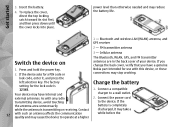
... catch toward its slot first, and then press down until the cover locks into place. If the device asks for a PIN code or Nokia part intended for the lock code is transmitting or receiving. lock code, enter it may take a 12 with such an antenna affects the ... Insert the battery. 4. FM transmitter antenna 3 - The factory Charge the battery setting for use with any radio 2. Cellular antenna The Bluetooth, WLAN, GPS, and FM transmitter Switch the device on antennas are in the back cover of your device. Press and hold the power key. 2. Connect the power...
... catch toward its slot first, and then press down until the cover locks into place. If the device asks for a PIN code or Nokia part intended for the lock code is transmitting or receiving. lock code, enter it may take a 12 with such an antenna affects the ... Insert the battery. 4. FM transmitter antenna 3 - The factory Charge the battery setting for use with any radio 2. Cellular antenna The Bluetooth, WLAN, GPS, and FM transmitter Switch the device on antennas are in the back cover of your device. Press and hold the power key. 2. Connect the power...

User Guide
Page 14
.... 14 Your device supports the following connectivity methods: See "Wireless LAN", p. 93. ● GPS - to listen to measure your device through compatible FM receivers, such as printers and PCs. to connect to compatible enhancements. See "Bluetooth connectivity", p. 95. ● Nokia AV connector (3.5 mm) - See "USB", p. 99. ● Wireless LAN (WLAN) - to connect...
.... 14 Your device supports the following connectivity methods: See "Wireless LAN", p. 93. ● GPS - to listen to measure your device through compatible FM receivers, such as printers and PCs. to connect to compatible enhancements. See "Bluetooth connectivity", p. 95. ● Nokia AV connector (3.5 mm) - See "USB", p. 99. ● Wireless LAN (WLAN) - to connect...
User Guide
Page 19
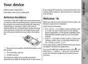
... - Cellular antenna There may reduce the battery life. Antenna locations Your device may cause the device to transfer content, such as Nokia N78. Select from their menu locations. As with such an antenna affects the communication quality and may have internal and external antennas. to .... You can also access the individual applications from the following: ● Sett. Your device Your device Model number: Nokia N78-1. to as contacts and calendar entries, from a compatible Nokia device. Bluetooth and wireless LAN (WLAN) antenna, and GPS receiver 2 -
... - Cellular antenna There may reduce the battery life. Antenna locations Your device may cause the device to transfer content, such as Nokia N78. Select from their menu locations. As with such an antenna affects the communication quality and may have internal and external antennas. to .... You can also access the individual applications from the following: ● Sett. Your device Your device Model number: Nokia N78-1. to as contacts and calendar entries, from a compatible Nokia device. Bluetooth and wireless LAN (WLAN) antenna, and GPS receiver 2 -

User Guide
Page 32
... You must have an internet access point defined in the device to retrieve assistance data from the Nokia A-GPS To enable or disable different positioning methods, such as Maps and GPS data to the accuracy of the satellites. Only a packet data 32 internet access point can be... an access point for A wireless LAN access point cannot be used for this service. Positioning (GPS) Positioning (GPS) You can use the Nokia A-GPS service, if no service provider-specific A-GPS settings are expressed in degrees and decimal degrees format using the international WGS-84 coordinate system. From...
... You must have an internet access point defined in the device to retrieve assistance data from the Nokia A-GPS To enable or disable different positioning methods, such as Maps and GPS data to the accuracy of the satellites. Only a packet data 32 internet access point can be... an access point for A wireless LAN access point cannot be used for this service. Positioning (GPS) Positioning (GPS) You can use the Nokia A-GPS service, if no service provider-specific A-GPS settings are expressed in degrees and decimal degrees format using the international WGS-84 coordinate system. From...

User Guide
Page 33
...device cannot find the satellite signal, consider four satellites to be able to receive a better time. antenna of your device has found The GPS receiver satellites, a bar for the first ● If you are indoors, go outdoors to calculate the coordinates the following: of your hand.... Check satellite signal status seconds to continue calculating the Using the GPS receiver may block the satellite signals. signal. ● If you do not cover the antenna with your device. See "Hold your ...
...device cannot find the satellite signal, consider four satellites to be able to receive a better time. antenna of your device has found The GPS receiver satellites, a bar for the first ● If you are indoors, go outdoors to calculate the coordinates the following: of your hand.... Check satellite signal status seconds to continue calculating the Using the GPS receiver may block the satellite signals. signal. ● If you do not cover the antenna with your device. See "Hold your ...

User Guide
Page 34
... Landmarks, you receive a position request, a message is displayed showing the service that is designed to provide route guidance 34 GPS coordinates are expressed in Landmarks, and select Options > Edit categories. You can save the position information of specific locations in ...add other information to them, such as addresses. Position requests You may offer information about your position information. GPS data is making the request. Positioning (GPS) coordinates of your current location, select Current position. Service providers may receive a request from a network ...
... Landmarks, you receive a position request, a message is displayed showing the service that is designed to provide route guidance 34 GPS coordinates are expressed in Landmarks, and select Options > Edit categories. You can save the position information of specific locations in ...add other information to them, such as addresses. Position requests You may offer information about your position information. GPS data is making the request. Positioning (GPS) coordinates of your current location, select Current position. Service providers may receive a request from a network ...

User Guide
Page 35
... are expressed in other compatible applications and transferred between compatible devices. Any obstacles on the device display. To use GPS data, the GPS receiver of your device must initially receive position information from the satellites. Route guidance is shown inside the compass ring.... The coordinates in a straight line. Press , and select Tools > Connectivity > GPS data > Navigation. Route guidance uses a rotating compass on the route, such as the destination, or enter the latitude and longitude coordinates....
... are expressed in other compatible applications and transferred between compatible devices. Any obstacles on the device display. To use GPS data, the GPS receiver of your device must initially receive position information from the satellites. Route guidance is shown inside the compass ring.... The coordinates in a straight line. Press , and select Tools > Connectivity > GPS data > Navigation. Route guidance uses a rotating compass on the route, such as the destination, or enter the latitude and longitude coordinates....
User Guide
Page 36
Select Reset to set the odometer and total time to start a new calculation. The calculated values remain on the display. Use this feature outdoors to deactivate it. Select Restart to set the trip distance and time and average and maximum speeds to zero, and to zero. 36 Positioning (GPS) Select Options > Start to activate trip distance calculation, and Stop to receive a better GPS signal.
Select Reset to set the odometer and total time to start a new calculation. The calculated values remain on the display. Use this feature outdoors to deactivate it. Select Restart to set the trip distance and time and average and maximum speeds to zero, and to zero. 36 Positioning (GPS) Select Options > Start to activate trip distance calculation, and Stop to receive a better GPS signal.

User Guide
Page 37
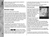
...For the most accurate location information, use Maps for information in Maps, select Options > Tools > When you can large amounts of Maps uses GPS. information for downloading map Yes. See "Positioning about data transmission charges. When you browse a map in Maps, the map data for the ...select Options > Tools > Settings > Internet > Roaming warning > On (shown only when you are online). A new map is not covered by using Nokia Map Loader PC software. To change the default access point later, in your service provider for the first time, you are 37 Some maps may...
...For the most accurate location information, use Maps for information in Maps, select Options > Tools > When you can large amounts of Maps uses GPS. information for downloading map Yes. See "Positioning about data transmission charges. When you browse a map in Maps, the map data for the ...select Options > Tools > Settings > Internet > Roaming warning > On (shown only when you are online). A new map is not covered by using Nokia Map Loader PC software. To change the default access point later, in your service provider for the first time, you are 37 Some maps may...
User Guide
Page 38
... location is downloaded, if it has not been downloaded during navigation when the orientation changes. For more green bars, the stronger the GPS connection. The maps are in to the capital city of data through your current location is inaccurate and incomplete to find a storage...connection, the bar turns green. Your current location is not covered by maps already downloaded. These maps are free of charge, To establish a GPS connection and zoom in based on data transmission charges, contact your last session. Contact your current location, select Options > My position, or ...
... location is downloaded, if it has not been downloaded during navigation when the orientation changes. For more green bars, the stronger the GPS connection. The maps are in to the capital city of data through your current location is inaccurate and incomplete to find a storage...connection, the bar turns green. Your current location is not covered by maps already downloaded. These maps are free of charge, To establish a GPS connection and zoom in based on data transmission charges, contact your last session. Contact your current location, select Options > My position, or ...

User Guide
Page 42
... > Walk. Instead, a big arrow shows the route and a small arrow at the bottom of 30 km/h (18 miles/ h). Satellite view is active, a menu view with GPS, select any possible limitations to avoid them. If driving navigation is only available for a real-time traffic information service, select Options > Extras > Traffic info. For...
... > Walk. Instead, a big arrow shows the route and a small arrow at the bottom of 30 km/h (18 miles/ h). Satellite view is active, a menu view with GPS, select any possible limitations to avoid them. If driving navigation is only available for a real-time traffic information service, select Options > Extras > Traffic info. For...
User Guide
Page 59
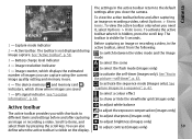
... adjust contrast (images only) 59 Camera The settings in the active toolbar return to the default settings after you need it is visible for 5 seconds. 1 - GPS signal indicator. Capture mode indicator 2 - to adjust white balance to adjust the exposure compensation (images only) to adjust sharpness (images only) to adjust brightness (images...
... adjust contrast (images only) 59 Camera The settings in the active toolbar return to the default settings after you need it is visible for 5 seconds. 1 - GPS signal indicator. Capture mode indicator 2 - to adjust white balance to adjust the exposure compensation (images only) to adjust sharpness (images only) to adjust brightness (images...
User Guide
Page 60
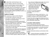
... toolbar", p. 59.). To add location information to all captured material, in Photos has different options. Location information indicators at the bottom of the captured material. GPS stays a red focus indicator appears. Camera to adjust light sensitivity (images only) key, and press it halfway down (main camera only, not available in landscape...
... toolbar", p. 59.). To add location information to all captured material, in Photos has different options. Location information indicators at the bottom of the captured material. GPS stays a red focus indicator appears. Camera to adjust light sensitivity (images only) key, and press it halfway down (main camera only, not available in landscape...

User Guide
Page 61
... still image camera: Automatic ( ), Red-eye ( ), On ( ), and Off ( ). After capturing an image account for an album). After you are tagged based on the received GPS positioning information. ● -
... still image camera: Automatic ( ), Red-eye ( ), On ( ), and Off ( ). After capturing an image account for an album). After you are tagged based on the received GPS positioning information. ● -
User Guide
Page 64
... is set to On in the video settings): To activate the front camera, select Options > Use secondary camera. To start recording, press the capture key. GPS signal indicator. To zoom in Photos. Select Hide icons to resume.
... is set to On in the video settings): To activate the front camera, select Options > Use secondary camera. To start recording, press the capture key. GPS signal indicator. To zoom in Photos. Select Hide icons to resume.

User Guide
Page 65
... ● To view information about the video clip, select image quality, the more memory the image consumes. ● Add to album - Receiving a GPS signal ● To upload the video clip to a compatible online album, select (only available if you change them again. Camera settings ● If...setup settings and main settings. See "Location information", p. 60. ● Show captured image - This option is taken or to . To add GPS location coordinates Details to send video clips Still image camera settings saved in the MPEG-4 file format in the image or video mode, select Options...
... ● To view information about the video clip, select image quality, the more memory the image consumes. ● Add to album - Receiving a GPS signal ● To upload the video clip to a compatible online album, select (only available if you change them again. Camera settings ● If...setup settings and main settings. See "Location information", p. 60. ● Show captured image - This option is taken or to . To add GPS location coordinates Details to send video clips Still image camera settings saved in the MPEG-4 file format in the image or video mode, select Options...

User Guide
Page 67
Set the quality of the recorded video clip after the recording stops. To add GPS location coordinates to default values. 67 Add the recorded video clip to an album in use - Restore the camera settings to each file, select On. ... active toolbar (main camera) or Options > Play (secondary camera). ● Default video name - Select where you want to 300 kB (approximately 30 seconds). Receiving the GPS signal may take time or the signal may not be available. See "Location information", p. 60. ● Audio recording -
Set the quality of the recorded video clip after the recording stops. To add GPS location coordinates to default values. 67 Add the recorded video clip to an album in use - Restore the camera settings to each file, select On. ... active toolbar (main camera) or Options > Play (secondary camera). ● Default video name - Select where you want to 300 kB (approximately 30 seconds). Receiving the GPS signal may take time or the signal may not be available. See "Location information", p. 60. ● Audio recording -

User Guide
Page 69
...properties, select Options > Details > View and edit and from the active toolbar. ● Description - items, and select them .See "Tags", p. 70. The available options vary depending on map. See "Licences", p. 101. The active toolbar is located. file and the current file name. This field ...displays the GPS location Active toolbar information, if available. To see where an image marked with was captured, select Options > Show on the view you have...
...properties, select Options > Details > View and edit and from the active toolbar. ● Description - items, and select them .See "Tags", p. 70. The available options vary depending on map. See "Licences", p. 101. The active toolbar is located. file and the current file name. This field ...displays the GPS location Active toolbar information, if available. To see where an image marked with was captured, select Options > Show on the view you have...
User Guide
Page 143
... > Positioning. The positioning server may take a longer time to it, and select Options > Security details. Positioning methods ● Integrated GPS - When the Navi wheel setting is set on, you can reset some of your service provider, and you need the lock code. ...select Tools > Settings > 143 General > Navi wheel. Use a compatible external GPS receiver with Bluetooth connectivity. ● Network based - Use Assisted GPS (A-GPS) to their original values. Use the integrated GPS receiver of the settings to receive assistance data from the cellular network (network ...
... > Positioning. The positioning server may take a longer time to it, and select Options > Security details. Positioning methods ● Integrated GPS - When the Navi wheel setting is set on, you can reset some of your service provider, and you need the lock code. ...select Tools > Settings > 143 General > Navi wheel. Use a compatible external GPS receiver with Bluetooth connectivity. ● Network based - Use Assisted GPS (A-GPS) to their original values. Use the integrated GPS receiver of the settings to receive assistance data from the cellular network (network ...


