
Triton User Manual Addendum - English, French, Spanish
Page 1
... are done. On the contextual menu, select "Start New Track". As you move, the Triton will be presented with the option of the space defined by pressing the MENU button. Triton User Manual Addendum This addendum applies to Triton GPS receivers that have a software version that is that you can now access the Main Menu... the perimeter and area of assigning a name to connect the start and end points of the User Grid. Pause and Resume Active Track. Triton 300 Triton 400 Triton 500 Triton 1500 Triton 2000 01.90.00.0279 01.74.00.0278 01.92.00.0283 01.53.00.0134 01.68.00.0138 The Main Menu...
... are done. On the contextual menu, select "Start New Track". As you move, the Triton will be presented with the option of the space defined by pressing the MENU button. Triton User Manual Addendum This addendum applies to Triton GPS receivers that have a software version that is that you can now access the Main Menu... the perimeter and area of assigning a name to connect the start and end points of the User Grid. Pause and Resume Active Track. Triton 300 Triton 400 Triton 500 Triton 1500 Triton 2000 01.90.00.0279 01.74.00.0278 01.92.00.0283 01.53.00.0134 01.68.00.0138 The Main Menu...

Triton User Manual Addendum - English, French, Spanish
Page 2
...any navigational screen. When done, the Navigation screen will be displayed with options to navigate next too. When setting a custom position, the GPS portion of the receiver is disabled and the screen is activated it to go there instead of the entire route. With the point defined, select "Enable Custom...be presented with User Grid set as the map datum. Set Custom Position. Press ENTER. When selecting a user datum, you can tell the Triton to go to the next destination (C) and repeat the process to go to bring up the contextual menu. Provide the settings for the User ...
...any navigational screen. When done, the Navigation screen will be displayed with options to navigate next too. When setting a custom position, the GPS portion of the receiver is disabled and the screen is activated it to go there instead of the entire route. With the point defined, select "Enable Custom...be presented with User Grid set as the map datum. Set Custom Position. Press ENTER. When selecting a user datum, you can tell the Triton to go to the next destination (C) and repeat the process to go to bring up the contextual menu. Provide the settings for the User ...
Manual - English
Page 2
Taking your selected destination. USE CARE The Global Positioning System (GPS) is operated by poor satellite geometry and obstructions, like buildings and large trees. i When using the Magellan Triton, these safety rules must be followed to prevent accidents that can result in an accident in which is ... use of this guide may severely degrade performance or damage the receiver, and will void the warranty. No part of non-Magellan cables and antennas may be affected by the periodic adjustments to GPS satellites made by any settings on one device for the accuracy and...
Taking your selected destination. USE CARE The Global Positioning System (GPS) is operated by poor satellite geometry and obstructions, like buildings and large trees. i When using the Magellan Triton, these safety rules must be followed to prevent accidents that can result in an accident in which is ... use of this guide may severely degrade performance or damage the receiver, and will void the warranty. No part of non-Magellan cables and antennas may be affected by the periodic adjustments to GPS satellites made by any settings on one device for the accuracy and...

Manual - English
Page 9
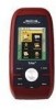
...Magellan Triton Ease-of the Wide Area Augmentation System for the Magellan Triton 300, loaded onto the internal memory. The Magellan Triton is also WAAS and EGNOS-capable, taking advantage of -use - SD-card expansion - (Triton 400 & 500 only) Use an optional SD memory card to add detailed maps - The SiRFstarIII™ GPS... enjoyable. Be sure to register your Magellan Triton at www.magellangps.com/support/ and select your Magellan Triton model for the outdoor enthusiast with multiple destinations or just use of the Magellan Triton GPS receiver. Routes and tracks - Built-in ...
...Magellan Triton Ease-of the Wide Area Augmentation System for the Magellan Triton 300, loaded onto the internal memory. The Magellan Triton is also WAAS and EGNOS-capable, taking advantage of -use - SD-card expansion - (Triton 400 & 500 only) Use an optional SD memory card to add detailed maps - The SiRFstarIII™ GPS... enjoyable. Be sure to register your Magellan Triton at www.magellangps.com/support/ and select your Magellan Triton model for the outdoor enthusiast with multiple destinations or just use of the Magellan Triton GPS receiver. Routes and tracks - Built-in ...

Manual - English
Page 11
..., IPX-7 Built-in multidirectional patch Nine direct-access keys 14° to 140°F (-10° to 60°C) PERFORMANCE Receiver Acquisition Time Update Rate Accuracy Languages Coordinate Systems SiRF Star III™ 20 channels, WAAS/EGNOS Hot: 20 seconds, Cold: 60 seconds...3 POWER Source Battery Life Two AA Batteries (not included) Up to 5 meters (10 - 16 feet) - WAAS/EGNOS, < 7 meters (15 feet) - GPS only English, French, German, Dutch, Danish, Swedish, Spanish, Italian, Portuguese, Finnish, Norwegian Latitude/Longitude, UTM, OSGB, Irish, Swish, Swedish, Finnish, German, French...
..., IPX-7 Built-in multidirectional patch Nine direct-access keys 14° to 140°F (-10° to 60°C) PERFORMANCE Receiver Acquisition Time Update Rate Accuracy Languages Coordinate Systems SiRF Star III™ 20 channels, WAAS/EGNOS Hot: 20 seconds, Cold: 60 seconds...3 POWER Source Battery Life Two AA Batteries (not included) Up to 5 meters (10 - 16 feet) - WAAS/EGNOS, < 7 meters (15 feet) - GPS only English, French, German, Dutch, Danish, Swedish, Spanish, Italian, Portuguese, Finnish, Norwegian Latitude/Longitude, UTM, OSGB, Irish, Swish, Swedish, Finnish, German, French...
Manual - English
Page 17
... cycle through the backlight intensities. (Alternate method) 1. Select View. 3. Disable the electronic compass if GPS fix is available. (Magellan Triton 500) 1. Select Volume & Brightness. 5. Press MENU. 2. Select Settings. 4. Use the left side of the receiver) to cycle through the backlight intensities. (Alternate method) 1. Select View. Press MENU. 2. Select Volume & Brightness. 5. Select Volume & Brightness. 5. Press...
... cycle through the backlight intensities. (Alternate method) 1. Select View. 3. Disable the electronic compass if GPS fix is available. (Magellan Triton 500) 1. Select Volume & Brightness. 5. Press MENU. 2. Select Settings. 4. Use the left side of the receiver) to cycle through the backlight intensities. (Alternate method) 1. Select View. Press MENU. 2. Select Volume & Brightness. 5. Select Volume & Brightness. 5. Press...
Manual - English
Page 26
... of the destination point, the number should be a negative distance if the user moves away from trees, tunnels, tall buildings, canyons, broadcast satellites, and other GPS receivers too close in distance) the progress the user has made . Distance Made Good (DMG) Distance Made Good measures (in proximity. Normally the accuracy is travelling...
... of the destination point, the number should be a negative distance if the user moves away from trees, tunnels, tall buildings, canyons, broadcast satellites, and other GPS receivers too close in distance) the progress the user has made . Distance Made Good (DMG) Distance Made Good measures (in proximity. Normally the accuracy is travelling...

Manual - English
Page 27
Map Screen Overview Battery Level Time of Day GPS Signal Strength North Indicator Data Fields Map Scale Pan Mode Map Legend Present Position Cursor (Points in the Magellan Triton and it has a special contextual menu that can be performed directly from this screen an important part of getting...destination from the Waypoint Information screen.) Map Screen 19 Red dot points towards your receiver. This makes understanding the Map screen and all of the functions that has been saved in the receiver.) Start Flag (Indicates the starting point of the active route.) End Flag (...
Map Screen Overview Battery Level Time of Day GPS Signal Strength North Indicator Data Fields Map Scale Pan Mode Map Legend Present Position Cursor (Points in the Magellan Triton and it has a special contextual menu that can be performed directly from this screen an important part of getting...destination from the Waypoint Information screen.) Map Screen 19 Red dot points towards your receiver. This makes understanding the Map screen and all of the functions that has been saved in the receiver.) Start Flag (Indicates the starting point of the active route.) End Flag (...
Manual - English
Page 37
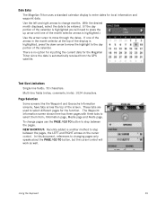
...NEW SHORTCUT: Recently added is highlighted, press the down arrow to select them from the GPS satellite. The Waypoint Information screen shown here has three pages with three tabs to move through... GO TO button, but the cursor control will need to select different pages for the Magellan Triton since the date is highlighted.) Use the arrow cursor to move the highlight to enter... dates for local information and waypoint data. Date Entry The Magellan Triton uses a standard calendar display to the day portion of the screen. Multi-line fields (notes...
...NEW SHORTCUT: Recently added is highlighted, press the down arrow to select them from the GPS satellite. The Waypoint Information screen shown here has three pages with three tabs to move through... GO TO button, but the cursor control will need to select different pages for the Magellan Triton since the date is highlighted.) Use the arrow cursor to move the highlight to enter... dates for local information and waypoint data. Date Entry The Magellan Triton uses a standard calendar display to the day portion of the screen. Multi-line fields (notes...
Manual - English
Page 61
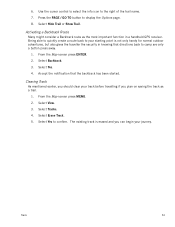
... the Map screen press MENU. 2. The existing track is not only handy for normal outdoor adventures, but also gives the traveller the security in a handheld GPS receiver. Select Backtrack. 3. Select Yes to the right of the trail name. 7. Use the cursor control to select the info icon to confirm. From the Map...
... the Map screen press MENU. 2. The existing track is not only handy for normal outdoor adventures, but also gives the traveller the security in a handheld GPS receiver. Select Backtrack. 3. Select Yes to the right of the trail name. 7. Use the cursor control to select the info icon to confirm. From the Map...


