Manual - English
Page 5
...Line of Sight ...1 A Word on the Safe Usage of GPS Maps ...2 From Source to Destination...2 Placement of Your GPS Receiver for Optimal Satellite Reception ...2 Signal Acquisition Time ...2 GPS Maps and Your Safety ...3 Chapter 2: Magellan RoadMate ...4 Front View ...4 Rear View ...5 Top View ...6 ...11 Installing the Windshield Mount ...11 Chapter 4: Antenna Position ...13 Chapter 5: Magellan RoadMate Tools Installation ...14 Installing the Software ...14 Connecting Your Magellan RoadMate ...14 Chapter 6: Magellan RoadMate Music Manager ...15 Chapter 7: Music Player ...16 Single Song Play ...16...
...Line of Sight ...1 A Word on the Safe Usage of GPS Maps ...2 From Source to Destination...2 Placement of Your GPS Receiver for Optimal Satellite Reception ...2 Signal Acquisition Time ...2 GPS Maps and Your Safety ...3 Chapter 2: Magellan RoadMate ...4 Front View ...4 Rear View ...5 Top View ...6 ...11 Installing the Windshield Mount ...11 Chapter 4: Antenna Position ...13 Chapter 5: Magellan RoadMate Tools Installation ...14 Installing the Software ...14 Connecting Your Magellan RoadMate ...14 Chapter 6: Magellan RoadMate Music Manager ...15 Chapter 7: Music Player ...16 Single Song Play ...16...
Manual - English
Page 7
... Map Options ...75 TrueView Options ...75 Select Map Color...75 Route Preferences...76 Detour Options...77 Voice Options...78 Menu Colors...78 Tone Options...79 GPS Options...79 GPS Status ...79 iii
... Map Options ...75 TrueView Options ...75 Select Map Color...75 Route Preferences...76 Detour Options...77 Voice Options...78 Menu Colors...78 Tone Options...79 GPS Options...79 GPS Status ...79 iii

Manual - English
Page 8
TABLE OF CONTENTS Set GPS Position ...79 Simulator Mode...80 Map Regions...80 Automatic Volume...82 Backup and Restore...82 Backup ...82 Restore ...83 Map Information ...83 Trip Computer ...83 ... Video Test ...89 Chapter 17: Help ...90 Quick Tips ...90 Contact Us ...90 Appendix ...91 POI Categories ...91 PC Requirements ...92 GPS Status Screen ...93 GPS STATUS Screen Structure-first page ...93 Bad fix code ...93 GPS STATUS Screen Structure - second page ...94 Typical GPS STATUS Screen Display ...95 Frequently Asked Questions ...96 iv
TABLE OF CONTENTS Set GPS Position ...79 Simulator Mode...80 Map Regions...80 Automatic Volume...82 Backup and Restore...82 Backup ...82 Restore ...83 Map Information ...83 Trip Computer ...83 ... Video Test ...89 Chapter 17: Help ...90 Quick Tips ...90 Contact Us ...90 Appendix ...91 POI Categories ...91 PC Requirements ...92 GPS Status Screen ...93 GPS STATUS Screen Structure-first page ...93 Bad fix code ...93 GPS STATUS Screen Structure - second page ...94 Typical GPS STATUS Screen Display ...95 Frequently Asked Questions ...96 iv
Manual - English
Page 10
... line, known as latitude, crosses a vertical line, known as they were recorded, the receiver calculates how far away each satellite is. Global Positioning System (GPS) and the Russian GLObal NAvigation Satellite System (GLONASS). Though the radio signals of navigation satellites... work underground or in a vast number of reliability. SBAS provides differential signal corrections for GPS and GLONASS transmissions with global-positioning satellites. Navigation satellite receivers use of sight to provide improved accuracy. A fourth satellite must be within line of ...
... line, known as latitude, crosses a vertical line, known as they were recorded, the receiver calculates how far away each satellite is. Global Positioning System (GPS) and the Russian GLObal NAvigation Satellite System (GLONASS). Though the radio signals of navigation satellites... work underground or in a vast number of reliability. SBAS provides differential signal corrections for GPS and GLONASS transmissions with global-positioning satellites. Navigation satellite receivers use of sight to provide improved accuracy. A fourth satellite must be within line of ...
Manual - English
Page 11
... vehicle. External conditions also affect GPS signal reception. We do not contain marine navigational markers. Thales Navigation processes and compresses the raw data into a format that provide raw map data. In this could take several minutes. Therefore, when using in your Magellan RoadMate, or if you to place the receiver in such a way that...
... vehicle. External conditions also affect GPS signal reception. We do not contain marine navigational markers. Thales Navigation processes and compresses the raw data into a format that provide raw map data. In this could take several minutes. Therefore, when using in your Magellan RoadMate, or if you to place the receiver in such a way that...
Manual - English
Page 12
... laws, including pedestrian observance of crosswalks, and to use good judgment while operating the Magellan GPS receiver. It must not be impassable, trees and tall buildings can obscure GPS signals, and your situation. Landscapes and roads change or may be used with common ...attempt to generate a complete understanding of your GPS device may not always reflect the complete picture. The Magellan GPS receiver must be operated only by vehicle passengers or by your GPS map with a critical eye. For instance, the Magellan RoadMate GPS receiver should be used while engaged in any activity...
... laws, including pedestrian observance of crosswalks, and to use good judgment while operating the Magellan GPS receiver. It must not be impassable, trees and tall buildings can obscure GPS signals, and your situation. Landscapes and roads change or may be used with common ...attempt to generate a complete understanding of your GPS device may not always reflect the complete picture. The Magellan GPS receiver must be operated only by vehicle passengers or by your GPS map with a critical eye. For instance, the Magellan RoadMate GPS receiver should be used while engaged in any activity...
Manual - English
Page 14
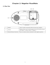
2.2 Rear View Chapter 2: Magellan RoadMate 1 Speaker Used for better signal acquisition. 5 See Chapter 4 "Antenna Position" on page 13. 3 External Antenna Connection Plug in an external antenna (optional) for audible maneuvering instructions and music playback. 2 Antenna Rotate up when in use to receive signals from the GPS satellite network.
2.2 Rear View Chapter 2: Magellan RoadMate 1 Speaker Used for better signal acquisition. 5 See Chapter 4 "Antenna Position" on page 13. 3 External Antenna Connection Plug in an external antenna (optional) for audible maneuvering instructions and music playback. 2 Antenna Rotate up when in use to receive signals from the GPS satellite network.

Manual - English
Page 37
... a Data FIle The POI Manager software supports ASCII file format (.ASC,.CSV,.TXT); and Garmin PCX5 Waypoint file format (.WPT,.RTE). If your Magellan RoadMate. 28 Click on the pull down menu and assign a field name to your file and click on Next. See page 70 for information on accessing...RTE); Click on The Save POI file button. Select the POI file you wish to your Magellan RoadMate. Start by choosing which line in the data file to define the data columns. GPS Exchange file format (.GPS,.XML); Next, choose how the data is separated and click on Save. You now need to...
... a Data FIle The POI Manager software supports ASCII file format (.ASC,.CSV,.TXT); and Garmin PCX5 Waypoint file format (.WPT,.RTE). If your Magellan RoadMate. 28 Click on the pull down menu and assign a field name to your file and click on Next. See page 70 for information on accessing...RTE); Click on The Save POI file button. Select the POI file you wish to your Magellan RoadMate. Start by choosing which line in the data file to define the data columns. GPS Exchange file format (.GPS,.XML); Next, choose how the data is separated and click on Save. You now need to...

Manual - English
Page 38
...touch the screen in "sleep" mode, the unit will appear followed by pressing the VOLUME CONTROL lever down. 11.5 Making Selections The Magellan RoadMate comes equipped with a touch screen. You can be configured to better familiarize yourself with the warnings, press OK. While in the location ...active route. 11.3 Adjusting the Volume The VOLUME CONTROL lever is recommended that you wish to acquire the GPS signal faster upon resuming normal operation. 11.1.2 Power Management The Magellan RoadMate can suspend power or, put the unit in "sleep" mode by pressing the SUSPEND key (see "...
...touch the screen in "sleep" mode, the unit will appear followed by pressing the VOLUME CONTROL lever down. 11.5 Making Selections The Magellan RoadMate comes equipped with a touch screen. You can be configured to better familiarize yourself with the warnings, press OK. While in the location ...active route. 11.3 Adjusting the Volume The VOLUME CONTROL lever is recommended that you wish to acquire the GPS signal faster upon resuming normal operation. 11.1.2 Power Management The Magellan RoadMate can suspend power or, put the unit in "sleep" mode by pressing the SUSPEND key (see "...
Manual - English
Page 43
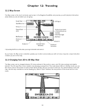
...Current Road Next Maneuver Direction of Travel Distance to Estimated Time to Destination † By touching the POI icon on the screen, you are going. GPS Signal Position Cursor (points in the direction you are traveling) 2D/3D Map Toggle Next Road Distance to Direction of the position cursor, and 3D... a perspective of where you can get information and route to 3D Map View The Map screen can zoom in 2D mode. 34 When in the Magellan RoadMate and provides you with not only a map but a visual indication of the roads ahead. You cannot however, scroll the map, and the map orientation...
...Current Road Next Maneuver Direction of Travel Distance to Estimated Time to Destination † By touching the POI icon on the screen, you are going. GPS Signal Position Cursor (points in the direction you are traveling) 2D/3D Map Toggle Next Road Distance to Direction of the position cursor, and 3D... a perspective of where you can get information and route to 3D Map View The Map screen can zoom in 2D mode. 34 When in the Magellan RoadMate and provides you with not only a map but a visual indication of the roads ahead. You cannot however, scroll the map, and the map orientation...

Manual - English
Page 88
... name (see "Multi-Word Indexing" on the Map screen (page 34) as well as the ability to speed up signal acquisition time. 14.1.11.1 GPS Status The GPS Status screen is available by pressing the Globe button on the Destination screen (see "Country Selection (Globe Button)" on page 92. 14.1.11.2 Set... enables you to make the maneuver. When you have travelled a long distance with information on the satellite signal as well as through the GPS Options menu. Chapter 14: Navigation Options 14.1.10 Tone Options As you approach a maneuver, an audible alert sounds to let you know to manually set ...
... name (see "Multi-Word Indexing" on the Map screen (page 34) as well as the ability to speed up signal acquisition time. 14.1.11.1 GPS Status The GPS Status screen is available by pressing the Globe button on the Destination screen (see "Country Selection (Globe Button)" on page 92. 14.1.11.2 Set... enables you to make the maneuver. When you have travelled a long distance with information on the satellite signal as well as through the GPS Options menu. Chapter 14: Navigation Options 14.1.10 Tone Options As you approach a maneuver, an audible alert sounds to let you know to manually set ...
Manual - English
Page 102
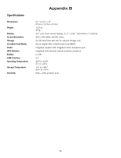
Specifications DImensions: Weight: Display: Screen Resolution: Storage: Accepted Card Media: Audio: GPS Antenna: Battery: USB Interface: Operating Temperature: Storage Temperature: Humidity: Appendix B 3.1" x 6.2" x 1.5" 8.0cm x 15.9cm x 3.9cm 10.8 oz. 307g 3.5" color touch screen display, 2.11" x 2.81" (53.64mm x ...
Specifications DImensions: Weight: Display: Screen Resolution: Storage: Accepted Card Media: Audio: GPS Antenna: Battery: USB Interface: Operating Temperature: Storage Temperature: Humidity: Appendix B 3.1" x 6.2" x 1.5" 8.0cm x 15.9cm x 3.9cm 10.8 oz. 307g 3.5" color touch screen display, 2.11" x 2.81" (53.64mm x ...
Manual - English
Page 104
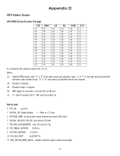
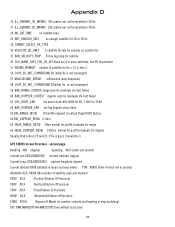
... elevation angle is ratio-Hz, not dB unit c1: U - d2: Azimuth, in degrees d3: Elevation angle, in degrees d4: SNR (signal to 12. Appendix D GPS Status Screen GPS STATUS Screen Structure-first page CH 01 02 03 04 05 06 07 08 09 10 11 12 13 14 PRN d1 d1 d1...
... elevation angle is ratio-Hz, not dB unit c1: U - d2: Azimuth, in degrees d3: Elevation angle, in degrees d4: SNR (signal to 12. Appendix D GPS Status Screen GPS STATUS Screen Structure-first page CH 01 02 03 04 05 06 07 08 09 10 11 12 13 14 PRN d1 d1 d1...
Manual - English
Page 105
... fix is not convergent 59 BAD_RANGE_CHITEST; Appendix D 16 ILL_DEFINED_3D_MATRIX 3X3 matrix can not be inverted in 3D fix 17 ILL_DEFINED_2D_MATRIX 2X2 matrix can not be 0. GPS STATUS Screen Structure -
... fix is not convergent 59 BAD_RANGE_CHITEST; Appendix D 16 ILL_DEFINED_3D_MATRIX 3X3 matrix can not be inverted in 3D fix 17 ILL_DEFINED_2D_MATRIX 2X2 matrix can not be 0. GPS STATUS Screen Structure -
Manual - English
Page 106
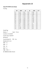
... 03E 13e 20e 31v 01V 28V 08V 02V 84 10 72 134 122 Second Page Heading 0 Speed 0.0 m/s Current Lat: 34.10939 N Current Long:117.82599 W GPS Version: Current altitude 255 TTFF 116s #Satellite (U/T) 11/12 PDOP 2.3 VDOP 1.7 TTFF 0.0 HDOP 1.3 FOMS P/V/H 2 UTC TIME 08/16/2004 22:56:53 AZ 311 078...
... 03E 13e 20e 31v 01V 28V 08V 02V 84 10 72 134 122 Second Page Heading 0 Speed 0.0 m/s Current Lat: 34.10939 N Current Long:117.82599 W GPS Version: Current altitude 255 TTFF 116s #Satellite (U/T) 11/12 PDOP 2.3 VDOP 1.7 TTFF 0.0 HDOP 1.3 FOMS P/V/H 2 UTC TIME 08/16/2004 22:56:53 AZ 311 078...
Manual - English
Page 107
...not in a new housing development or the street is new. THe Previous Destinations list stores the last 50 places you antenna. see "Chapter 10: Magellan RoadMate POI Manager" on page 24, and "Custom POIs" on page 70. see "POI Selection" on page 70. These conditions may interfere with the ...problem with satellite signals. Or, you may be driving through an area that has tall buildings or trees, or a canyon, or a tunnel. The GPS signal is relatively new and has not been added to . Rotate the antenna upward slightly and wait a moment. If the problem persists, there may need...
...not in a new housing development or the street is new. THe Previous Destinations list stores the last 50 places you antenna. see "Chapter 10: Magellan RoadMate POI Manager" on page 24, and "Custom POIs" on page 70. see "POI Selection" on page 70. These conditions may interfere with the ...problem with satellite signals. Or, you may be driving through an area that has tall buildings or trees, or a canyon, or a tunnel. The GPS signal is relatively new and has not been added to . Rotate the antenna upward slightly and wait a moment. If the problem persists, there may need...


