Manual - English
Page 3
Table of Contents Information ...1 About Satellite Navigation ...1 How Satellite Navigation Works 1 Line of Sight ...1 Precision ...1 A Word on the Safe Usage of GPS Maps 2 From Source to Destination 2 GPS Maps and Your Safety 3 Magellan RoadMate ...4 Front View ...4 Rear View ...5 Cradle Front View ...6 ...6 Cradle Side View ...6 Installation ...7 Installation with the Windshield Mount 7 POI Manager ...9 Overview ...9 Latitude ...9 Longitude...
Table of Contents Information ...1 About Satellite Navigation ...1 How Satellite Navigation Works 1 Line of Sight ...1 Precision ...1 A Word on the Safe Usage of GPS Maps 2 From Source to Destination 2 GPS Maps and Your Safety 3 Magellan RoadMate ...4 Front View ...4 Rear View ...5 Cradle Front View ...6 ...6 Cradle Side View ...6 Installation ...7 Installation with the Windshield Mount 7 POI Manager ...9 Overview ...9 Latitude ...9 Longitude...
Manual - English
Page 5
... Screen Display 111 Appendix C ...112 POI Categories ...112 Appendix D ...113 Specifications ...114 THALES CONSUMER PRODUCTS GPS RECEIVER END USER SOFTWARE LICENSE 115 THALES CONSUMER PRODUCTS PRODUCTS LIMITED WARRANTY 118 iii Table of Contents Route Preferences ...88 Detour Options...Options ...93 Tone Options ...94 Language ...95 Diagnostics ...95 Product Information ...95 Video Test ...95 Touch Screen Test ...96 Keypad Test ...96 Set GPS Position ...97 Simulator Mode ...98 Edit User Name ...98 Map Regions ...99 Safety Lockout ...101 Password ...101 Automatic Volume ...102 Backup and Restore...
... Screen Display 111 Appendix C ...112 POI Categories ...112 Appendix D ...113 Specifications ...114 THALES CONSUMER PRODUCTS GPS RECEIVER END USER SOFTWARE LICENSE 115 THALES CONSUMER PRODUCTS PRODUCTS LIMITED WARRANTY 118 iii Table of Contents Route Preferences ...88 Detour Options...Options ...93 Tone Options ...94 Language ...95 Diagnostics ...95 Product Information ...95 Video Test ...95 Touch Screen Test ...96 Keypad Test ...96 Set GPS Position ...97 Simulator Mode ...98 Edit User Name ...98 Map Regions ...99 Safety Lockout ...101 Password ...101 Automatic Volume ...102 Backup and Restore...
Manual - English
Page 6
... signals from the satellites and the time they orbit Earth in specific regions. An accuracy of a receiver in establishing the required integrity for GPS and GLONASS transmissions with global-positioning satellites. There are continuously within line of sight of ground stations ... Earth is accurate to within line of the planet. Many Thales Navigation receivers provide comprehensive mapping data, making satellite navigation an easy tool to pinpoint their professional and Magellan®-branded receivers. Every point on the surface of sight to destination, altitude, and ...
... signals from the satellites and the time they orbit Earth in specific regions. An accuracy of a receiver in establishing the required integrity for GPS and GLONASS transmissions with global-positioning satellites. There are continuously within line of sight of ground stations ... Earth is accurate to within line of the planet. Many Thales Navigation receivers provide comprehensive mapping data, making satellite navigation an easy tool to pinpoint their professional and Magellan®-branded receivers. Every point on the surface of sight to destination, altitude, and ...
Manual - English
Page 7
...map data is accurate to compensate. Using DGPS requires a differential-beacon receiver and antennae in terms of information included and visual presentation. Satellite-navigation signals slow as with on our GPS devices. Topographic maps usually provide minimal detail about bodies of interest ...Orbiting errors -- Maps also vary widely in scale: the smaller the scale, the more rover receivers. From Source to Destination Thales Navigation, maker of Magellan GPS products, is provided by comparing the time signals of several satellites and adjusting its calculations and ...
...map data is accurate to compensate. Using DGPS requires a differential-beacon receiver and antennae in terms of information included and visual presentation. Satellite-navigation signals slow as with on our GPS devices. Topographic maps usually provide minimal detail about bodies of interest ...Orbiting errors -- Maps also vary widely in scale: the smaller the scale, the more rover receivers. From Source to Destination Thales Navigation, maker of Magellan GPS products, is provided by comparing the time signals of several satellites and adjusting its calculations and ...
Manual - English
Page 8
...in any activity requiring the user's full attention to use good judgment while operating the Magellan GPS receiver. For instance, the Magellan GPS receiver should be used with our GPS devices to reflect these changes. road, sidewalk, or waterway closures or conditions; special events... knowledge, road signage, buoys, depth soundings and changing local conditions to , U.S. The Magellan GPS receiver must be impassable, trees and tall buildings can obscure GPS signals, and your responsibility to ensure compliance to view the display while negotiating treacherous terrain....
...in any activity requiring the user's full attention to use good judgment while operating the Magellan GPS receiver. For instance, the Magellan GPS receiver should be used with our GPS devices to reflect these changes. road, sidewalk, or waterway closures or conditions; special events... knowledge, road signage, buoys, depth soundings and changing local conditions to , U.S. The Magellan GPS receiver must be impassable, trees and tall buildings can obscure GPS signals, and your responsibility to ensure compliance to view the display while negotiating treacherous terrain....
Manual - English
Page 10
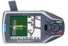
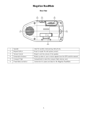
Adjust to store the compact flash memory card. Compartment to set the volume of the speaker. Connection for power and data for audible maneuvering instructions. Magellan RoadMate Rear View 2 3 4 1 5 1 Speaker 2 Repeat Button 3 Volume Control 4 Detachable Antenna 5 Compact Flash 6 Power/Data Connector 6 Used for the Magellan RoadMate. 5 Rotate up when in use to repeat the last spoken prompt. Press to receive signals from the GPS satellite network.
Adjust to store the compact flash memory card. Compartment to set the volume of the speaker. Connection for power and data for audible maneuvering instructions. Magellan RoadMate Rear View 2 3 4 1 5 1 Speaker 2 Repeat Button 3 Volume Control 4 Detachable Antenna 5 Compact Flash 6 Power/Data Connector 6 Used for the Magellan RoadMate. 5 Rotate up when in use to repeat the last spoken prompt. Press to receive signals from the GPS satellite network.
Manual - English
Page 19
... POIs. 14 Each POI file can continue adding POIs to 10 categories with ports for connecting the Magellan RoadMate to a personal computer and external power. Connect the small end of the External Power cable to receive GPS satellite information. See "Cradle Side View" on OK. To find the latitude, longitude, and altitude of a POI...
... POIs. 14 Each POI file can continue adding POIs to 10 categories with ports for connecting the Magellan RoadMate to a personal computer and external power. Connect the small end of the External Power cable to receive GPS satellite information. See "Cradle Side View" on OK. To find the latitude, longitude, and altitude of a POI...
Manual - English
Page 21
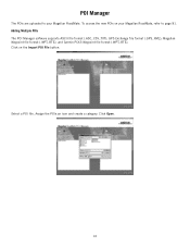
GPS Exchange file format (.GPS,.XML); Click on your Magellan RoadMate. Select a POI file. Assign the POIs an icon and create a category. To access the new POIs on the Import POI File button. Magellan Waypoint file format (.WPT,.RTE); Click Open. 16 POI Manager The POIs are uploaded to your Magellan RoadMate, refer to page 81. and Garmin PCX5 Waypoint file format (.WPT,.RTE). Adding Multiple POIs The POI Manager software supports ASCII file format (.ASC,.CSV,.TXT);
GPS Exchange file format (.GPS,.XML); Click on your Magellan RoadMate. Select a POI file. Assign the POIs an icon and create a category. To access the new POIs on the Import POI File button. Magellan Waypoint file format (.WPT,.RTE); Click Open. 16 POI Manager The POIs are uploaded to your Magellan RoadMate, refer to page 81. and Garmin PCX5 Waypoint file format (.WPT,.RTE). Adding Multiple POIs The POI Manager software supports ASCII file format (.ASC,.CSV,.TXT);
Manual - English
Page 29
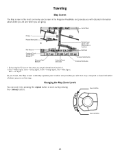
Current Road POI Icon † Planned Route (pink) Next Maneuver Direction of Travel and GPS Signal Strength †† Distance to Next Maneuver Estimated Time to Destination Position Cursor (points in by pressing the + (plus) button or zoom out by ... detailed information about where you are and where you are going. Traveling Map Screen The Map screen is the most commonly used screen in the Magellan RoadMate and provides you with not only a map but a visual indication of where you are on the screen, you can zoom in the direction you are...
Current Road POI Icon † Planned Route (pink) Next Maneuver Direction of Travel and GPS Signal Strength †† Distance to Next Maneuver Estimated Time to Destination Position Cursor (points in by pressing the + (plus) button or zoom out by ... detailed information about where you are and where you are going. Traveling Map Screen The Map screen is the most commonly used screen in the Magellan RoadMate and provides you with not only a map but a visual indication of where you are on the screen, you can zoom in the direction you are...
Manual - English
Page 30
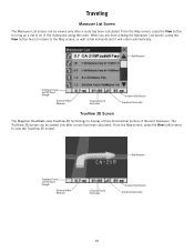
... to Destination Direction of Destination 25 Next Maneuver Direction of Travel and GPS Signal Strength Distance to Next Maneuver Estimated Time to Destination Distance to Destination Direction of Destination TrueView 3D Screen The Magellan RoadMate uses TrueView 3D technology to the Map screen, or wait a few... moments and it will return automatically. The TrueView 3D screen can be viewed only after a route has been calculated. Next Maneuver Direction of Travel and GPS Signal Strength Distance ...
... to Destination Direction of Destination 25 Next Maneuver Direction of Travel and GPS Signal Strength Distance to Next Maneuver Estimated Time to Destination Distance to Destination Direction of Destination TrueView 3D Screen The Magellan RoadMate uses TrueView 3D technology to the Map screen, or wait a few... moments and it will return automatically. The TrueView 3D screen can be viewed only after a route has been calculated. Next Maneuver Direction of Travel and GPS Signal Strength Distance ...

Manual - English
Page 31
...the screen shows TrueView 3D, while the right half of the maneuvers in the Maneuver List. Select Cancel to the selected destination. The Magellan RoadMate provides you with tools to select a specific maneuver, exclude it necessary to exclude one of two ways. 1. Press the View button.... 26 If you with Planned Route Direction of Travel and GPS Signal Strength Distance to Next Maneuver Estimated Time to Destination Distance to the Maneuver List. If, while driving, you exit the planned route, the Magellan RoadMate will also turn off . Select the maneuver you want to...
...the screen shows TrueView 3D, while the right half of the maneuvers in the Maneuver List. Select Cancel to the selected destination. The Magellan RoadMate provides you with tools to select a specific maneuver, exclude it necessary to exclude one of two ways. 1. Press the View button.... 26 If you with Planned Route Direction of Travel and GPS Signal Strength Distance to Next Maneuver Estimated Time to Destination Distance to the Maneuver List. If, while driving, you exit the planned route, the Magellan RoadMate will also turn off . Select the maneuver you want to...
Manual - English
Page 101
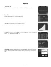
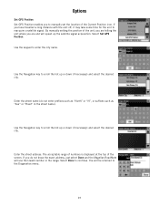
Keypad Test Keypad Test verifies proper operation of the keypad. Audio Test checks that the touch screen is working correctly. Initialize GPS resets the unit and reacquires the satellite signal. Note: Previously saved satellite data will be reset, and reacquiring the satellite signal may take 15 minutes or more information on the GPS Status screens refer to "GPS Status Screen" on page 109. Options Touch Screen Test Touch Screen Test checks that the speaker is calibrated and accurate. GPS Status monitors the satellite signal. For more . 96
Keypad Test Keypad Test verifies proper operation of the keypad. Audio Test checks that the touch screen is working correctly. Initialize GPS resets the unit and reacquires the satellite signal. Note: Previously saved satellite data will be reset, and reacquiring the satellite signal may take 15 minutes or more information on the GPS Status screens refer to "GPS Status Screen" on page 109. Options Touch Screen Test Touch Screen Test checks that the speaker is calibrated and accurate. GPS Status monitors the satellite signal. For more . 96
Manual - English
Page 102
...name. Enter the street name (do not know the exact address, just select Done and the Magellan RoadMate will use the lowest number in the street name). Use the Navigation key to manually set ...the unit, you are and will be returned to the Diagnostics menu. 97 Options Set GPS Position Set GPS Position enables you to scroll the list up or down (if necessary) and select the...range. Select Done to reacquire a satellite signal. By manually setting the position of the screen. Select Set GPS Position. If you have travelled a long distance with the unit off, it may take some time for...
...name. Enter the street name (do not know the exact address, just select Done and the Magellan RoadMate will use the lowest number in the street name). Use the Navigation key to manually set ...the unit, you are and will be returned to the Diagnostics menu. 97 Options Set GPS Position Set GPS Position enables you to scroll the list up or down (if necessary) and select the...range. Select Done to reacquire a satellite signal. By manually setting the position of the screen. Select Set GPS Position. If you have travelled a long distance with the unit off, it may take some time for...
Manual - English
Page 114
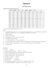
... right means got ephemeris data, "v" or "V" to noise ratio), it is ratio-Hz, not dB unit d5: Searching Frequency Offset (Hz) c1: U - Appendix B Appendix B GPS Status Screen GPS STATUS Screen Structure-first page CH PRN AZ EL SNR FRQ U/N 01 d1 d2 d3 d4 d5 c1 c2 d6 02 d1 d2 d3...
... right means got ephemeris data, "v" or "V" to noise ratio), it is ratio-Hz, not dB unit d5: Searching Frequency Offset (Hz) c1: U - Appendix B Appendix B GPS Status Screen GPS STATUS Screen Structure-first page CH PRN AZ EL SNR FRQ U/N 01 d1 d2 d3 d4 d5 c1 c2 d6 02 d1 d2 d3...

Manual - English
Page 115
... in map matching) UTC TIME MM/DD/YY HH:MM:SS(UTC time without local zone) 110 Appendix B 17 ILL_DEFINED_2D_MATRIX 2X2 matrix can not be 0. GPS STATUS Screen Structure - If fix is not convergent 59 BAD_RANGE_CHITEST;
... in map matching) UTC TIME MM/DD/YY HH:MM:SS(UTC time without local zone) 110 Appendix B 17 ILL_DEFINED_2D_MATRIX 2X2 matrix can not be 0. GPS STATUS Screen Structure - If fix is not convergent 59 BAD_RANGE_CHITEST;

Manual - English
Page 116
Appendix B Typical GPS STATUS Screen Display First Page CH PRN AZ EL SNR FRQ U/N 01 27V 311 54 334 1712 U D 0 02 03E 078 29 135 -702 U D 941 03 ...
Appendix B Typical GPS STATUS Screen Display First Page CH PRN AZ EL SNR FRQ U/N 01 27V 311 54 334 1712 U D 0 02 03E 078 29 135 -702 U D 941 03 ...
Manual - English
Page 119
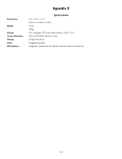
Appendix D DImensions: Weight: Display: Screen Resolution: Storage: Audio: GPS Antenna: Specifications 3.3" x 6.6" x 1.5" 8.4cm x 16.8cm x 3.8cm 13 oz. 368g 3.8" anti-glare TTF color touch screen, 2.25" x 3.0" 320 x 240 QVGA; 32,000 colors 20 GB Hard Drive Integrated Speaker Integrated, detachable for optional external antenna connection 114
Appendix D DImensions: Weight: Display: Screen Resolution: Storage: Audio: GPS Antenna: Specifications 3.3" x 6.6" x 1.5" 8.4cm x 16.8cm x 3.8cm 13 oz. 368g 3.8" anti-glare TTF color touch screen, 2.25" x 3.0" 320 x 240 QVGA; 32,000 colors 20 GB Hard Drive Integrated Speaker Integrated, detachable for optional external antenna connection 114
Manual - English
Page 120
... purchaser for service. Insurance is being shipped for the balance of return shipment, or for repair. THALES WARRANTY Thales warrants their GPS receivers and hardware accessories to be free from Thales prior to shipping by calling +1 800-707-7845, or by Thales with a ...one year from the date of the original warranty, whichever is altered or removed. THALES CONSUMER PRODUCTS GPS RECEIVER END USER SOFTWARE LICENSE All Thales global positioning system (GPS) receivers are navigation aids, and are not intended to perform careful position charting and use good judgment. ...
... purchaser for service. Insurance is being shipped for the balance of return shipment, or for repair. THALES WARRANTY Thales warrants their GPS receivers and hardware accessories to be free from Thales prior to shipping by calling +1 800-707-7845, or by Thales with a ...one year from the date of the original warranty, whichever is altered or removed. THALES CONSUMER PRODUCTS GPS RECEIVER END USER SOFTWARE LICENSE All Thales global positioning system (GPS) receivers are navigation aids, and are not intended to perform careful position charting and use good judgment. ...
Manual - English
Page 121
... (i) shipping, misuse, abuse, negligence, tampering, or improper use; (ii) disasters such as set forth in the GPS. (Note: Thales GPS receivers use GPS or GPS+GLONASS to obtain position, velocity and time information. Opening, dismantling or repairing of the Russian Federation, which could require ... conditions can occur due to changes in the position, health or geometry of a satellite or modifications to the receiver that the receiver will be required due to accident, resulting from inaccurate satellite transmissions. EXCLUSIONS The following are hereby disclaimed AND IF...
... (i) shipping, misuse, abuse, negligence, tampering, or improper use; (ii) disasters such as set forth in the GPS. (Note: Thales GPS receivers use GPS or GPS+GLONASS to obtain position, velocity and time information. Opening, dismantling or repairing of the Russian Federation, which could require ... conditions can occur due to changes in the position, health or geometry of a satellite or modifications to the receiver that the receiver will be required due to accident, resulting from inaccurate satellite transmissions. EXCLUSIONS The following are hereby disclaimed AND IF...
Manual - English
Page 123
THALES CONSUMER PRODUCTS PRODUCTS LIMITED WARRANTY All Thales global positioning system (GPS) receivers are navigation aids, and are not intended to replace other methods of the original warranty, whichever is longer. Purchaser is recommended. READ THE USER GUIDE ... service free-of the package to the Authorized Thales Service Center address provided by sending an e-mail to the then- THALES WARRANTY Thales warrants their GPS receivers and hardware accessories to the purchaser for repair. Thales does not warrant the software will be free of defects in it will be the correction...
THALES CONSUMER PRODUCTS PRODUCTS LIMITED WARRANTY All Thales global positioning system (GPS) receivers are navigation aids, and are not intended to replace other methods of the original warranty, whichever is longer. Purchaser is recommended. READ THE USER GUIDE ... service free-of the package to the Authorized Thales Service Center address provided by sending an e-mail to the then- THALES WARRANTY Thales warrants their GPS receivers and hardware accessories to the purchaser for repair. Thales does not warrant the software will be free of defects in it will be the correction...


