Manual - English
Page 4
... Saving a Previous Destination to Destination ...2 GPS Maps and Your Safety ...3 Care and Use of the Pre-Installed Secure Digital (SD) Card 3 To Insert the SD Card: ...4 To remove the SD card: ...4 Magellan RoadMate ...5 Front View ...5 Rear View ...5 ...Left- Table of Contents Information ...1 Technical Support ...2 Warranty Service ...2 Customer Service ...2 About Satellite Navigation ...1 How Satellite Navigation Works ...1 Line of Sight ...1 Precision ...1 Placement of Your GPS Receiver for Optimal Satellite Reception ...
... Saving a Previous Destination to Destination ...2 GPS Maps and Your Safety ...3 Care and Use of the Pre-Installed Secure Digital (SD) Card 3 To Insert the SD Card: ...4 To remove the SD card: ...4 Magellan RoadMate ...5 Front View ...5 Rear View ...5 ...Left- Table of Contents Information ...1 Technical Support ...2 Warranty Service ...2 Customer Service ...2 About Satellite Navigation ...1 How Satellite Navigation Works ...1 Line of Sight ...1 Precision ...1 Placement of Your GPS Receiver for Optimal Satellite Reception ...

Manual - English
Page 6
Edit Name ...82 Password Settings ...83 Appendix ...84 GPS Status Screen ...84 GPS STATUS Screen Structure-first page 84 Bad fix code ...84 GPS STATUS Screen Structure - Table of Contents Auto Power Off ...73 Language ...73 User Settings ...74 POI Selection ...74 Map Options ...75 Map Orientation ...75 Units ... Test ...78 Keypad Test ...78 Audio Test ...78 Headphone Test ...79 Product Information ...81 Simulator Mode ...81 System Messages ...82 User - second page 85 Typical GPS STATUS Screen Display 86 POI Categories ...87 Specifications ...89 iii
Edit Name ...82 Password Settings ...83 Appendix ...84 GPS Status Screen ...84 GPS STATUS Screen Structure-first page 84 Bad fix code ...84 GPS STATUS Screen Structure - Table of Contents Auto Power Off ...73 Language ...73 User Settings ...74 POI Selection ...74 Map Options ...75 Map Orientation ...75 Units ... Test ...78 Keypad Test ...78 Audio Test ...78 Headphone Test ...79 Product Information ...81 Simulator Mode ...81 System Messages ...82 User - second page 85 Typical GPS STATUS Screen Display 86 POI Categories ...87 Specifications ...89 iii

Manual - English
Page 7
...and sea, without the use of additional augmentation systems. While the GPS and GLONASS satellite networks are two Global Navigation Satellite Systems in operation: the U.S. Global Positioning System (GPS) and the Russian GLObal NAvigation Satellite System (GLONASS). GNSS-2 requires... Navigation Global satellite navigation is provided by a receiver, allowing users to pinpoint their professional and Magellan®-branded receivers. Though the radio signals of every position on an electronic map. The distance of the receiver from satellite navigation-augmentation systems. In the U.S.,...
...and sea, without the use of additional augmentation systems. While the GPS and GLONASS satellite networks are two Global Navigation Satellite Systems in operation: the U.S. Global Positioning System (GPS) and the Russian GLObal NAvigation Satellite System (GLONASS). GNSS-2 requires... Navigation Global satellite navigation is provided by a receiver, allowing users to pinpoint their professional and Magellan®-branded receivers. Though the radio signals of every position on an electronic map. The distance of the receiver from satellite navigation-augmentation systems. In the U.S.,...
Manual - English
Page 8
... accurate as they pass through the Earth's atmosphere. The external antenna mounts to 25 meters. The GPS receiver constantly monitors and updated the GPS signal status and will reacquire the signal once it in positioning: Atmospheric delay -- Topographic maps usually ... satellites and adjusting its calculations and its actual trajectory. Using DGPS requires a differential-beacon receiver and antennae in terms of Magellan GPS products, is a receiver capable of the receiver, the geometric calculations necessary for time differentials by other reflective coatings may be required to...
... accurate as they pass through the Earth's atmosphere. The external antenna mounts to 25 meters. The GPS receiver constantly monitors and updated the GPS signal status and will reacquire the signal once it in positioning: Atmospheric delay -- Topographic maps usually ... satellites and adjusting its calculations and its actual trajectory. Using DGPS requires a differential-beacon receiver and antennae in terms of Magellan GPS products, is a receiver capable of the receiver, the geometric calculations necessary for time differentials by other reflective coatings may be required to...
Manual - English
Page 9
...not attempt to turn the power off when removing or inserting the SD card. For instance, the Magellan GPS receiver should be impassable, trees and tall buildings can obscure GPS signals and your GPS device may cause the unit or the data on the SD card to never remove or insert ...taking a lot of crosswalks, and to both natural and man-made causes. The accuracy of the Pre-Installed Secure Digital (SD) Card The Magellan RoadMate 360 comes with common sense and it also. pavement characteristics or conditions; Always make sure to view the display while driving. The driver must push...
...not attempt to turn the power off when removing or inserting the SD card. For instance, the Magellan GPS receiver should be impassable, trees and tall buildings can obscure GPS signals and your GPS device may cause the unit or the data on the SD card to never remove or insert ...taking a lot of crosswalks, and to both natural and man-made causes. The accuracy of the Pre-Installed Secure Digital (SD) Card The Magellan RoadMate 360 comes with common sense and it also. pavement characteristics or conditions; Always make sure to view the display while driving. The driver must push...
Manual - English
Page 11
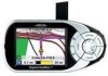
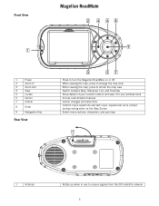
Front View Magellan RoadMate Magellan RoadMate 1 Power 2 Zoom In 3 Zoom Out 4 View 5 Locate 6 Option 7 Cancel 8 Enter 9 Navigation Key Rear View Press to receive signals from the GPS satellite network 5 While viewing the map, press to enlarge the map view While viewing the map, press to shrink the map view Switch between Map, ... voice prompt during routing while on the Map Screen Select menu options, characters, and pan map 1 Antenna Rotate up when in use to turn the Magellan RoadMate on or off.
Front View Magellan RoadMate Magellan RoadMate 1 Power 2 Zoom In 3 Zoom Out 4 View 5 Locate 6 Option 7 Cancel 8 Enter 9 Navigation Key Rear View Press to receive signals from the GPS satellite network 5 While viewing the map, press to enlarge the map view While viewing the map, press to shrink the map view Switch between Map, ... voice prompt during routing while on the Map Screen Select menu options, characters, and pan map 1 Antenna Rotate up when in use to turn the Magellan RoadMate on or off.
Manual - English
Page 66
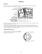
It provides you with detailed information about where you are and where you the option of Destination Distance to 1665 mi. If the Magellan RoadMate loses the satellite signal for your location. See "Selecting a POI on the Map" on (enlarge) the map or zoom out from ... levels range from (shrink) the map. Changing the Map Zoom Levels While in the Magellan RoadMate. Current Road Planned Route (pink) POI Icon Position Cursor Next Road Next Maneuver Direction of Travel and GPS Signal Strength Distance to Next Maneuver Estimated Time to Destination Direction of routing to that point...
It provides you with detailed information about where you are and where you the option of Destination Distance to 1665 mi. If the Magellan RoadMate loses the satellite signal for your location. See "Selecting a POI on the Map" on (enlarge) the map or zoom out from ... levels range from (shrink) the map. Changing the Map Zoom Levels While in the Magellan RoadMate. Current Road Planned Route (pink) POI Icon Position Cursor Next Road Next Maneuver Direction of Travel and GPS Signal Strength Distance to Next Maneuver Estimated Time to Destination Direction of routing to that point...

Manual - English
Page 67
Maneuver List Screen Traveling Next Maneuver Direction of Travel and GPS Signal Strength Distance to Next Maneuver 1/10 Mile Countdown Distance to Destination Estimated Time to Destination Direction of Destination TrueView Screen Direction of Travel and GPS Signal Strength Distance to Next Maneuver 1/10 Mile Countdown Distance to Destination Estimated Time to Destination Direction of Destination 61
Maneuver List Screen Traveling Next Maneuver Direction of Travel and GPS Signal Strength Distance to Next Maneuver 1/10 Mile Countdown Distance to Destination Estimated Time to Destination Direction of Destination TrueView Screen Direction of Travel and GPS Signal Strength Distance to Next Maneuver 1/10 Mile Countdown Distance to Destination Estimated Time to Destination Direction of Destination 61

Manual - English
Page 85
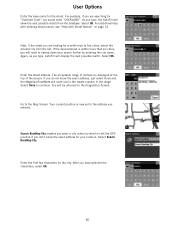
.... If you enter a specific address by Street. There are and will be reset and reacquiring the satellite signal may take some time for setting the GPS position: Search by Street enables you have traveled a long distance with the unit off, it may take 15 minutes or more. Set... GPS Position Enables you are two options for the unit to set the location of the unit you are telling the unit where you to the ...
.... If you enter a specific address by Street. There are and will be reset and reacquiring the satellite signal may take some time for setting the GPS position: Search by Street enables you have traveled a long distance with the unit off, it may take 15 minutes or more. Set... GPS Position Enables you are two options for the unit to set the location of the unit you are telling the unit where you to the ...
Manual - English
Page 86
... of numbers is displayed at the top of the screen. Go to the lowest number in the range. Your current position is now set the GPS position if you will route you are looking for the street. Again, as you have selected the characters, select OK. 80 If you do not... City. User Options Enter the base name for is within more than six cities, you don't know the exact address, just select Done and the Magellan RoadMate will need to narrow down your location. For example, if you to the Map Screen. For additional help with entering street names, see "Help with...
... of numbers is displayed at the top of the screen. Go to the lowest number in the range. Your current position is now set the GPS position if you will route you are looking for the street. Again, as you have selected the characters, select OK. 80 If you do not... City. User Options Enter the base name for is within more than six cities, you don't know the exact address, just select Done and the Magellan RoadMate will need to narrow down your location. For example, if you to the Map Screen. For additional help with entering street names, see "Help with...

Manual - English
Page 90
... check). Used for this channel. Reacquisition, T- A non-zero value is either waiting for position fix c2: Mode of the channel: I- Idle, S-searching, B - Appendix A Appendix GPS Status Screen GPS STATUS Screen Structure-first page CH PRN AZ EL SNR FRQ U/N 01 d1 d2 d3 d4 d5 c1 c2 d6 02 d1 d2 d3...
... check). Used for this channel. Reacquisition, T- A non-zero value is either waiting for position fix c2: Mode of the channel: I- Idle, S-searching, B - Appendix A Appendix GPS Status Screen GPS STATUS Screen Structure-first page CH PRN AZ EL SNR FRQ U/N 01 d1 d2 d3 d4 d5 c1 c2 d6 02 d1 d2 d3...

Manual - English
Page 91
... level meter) TTFF XXXXs (Time-To-First-Fix in map matching) UTC TIME MM/DD/YY HH:MM:SS(UTC time without local zone) 85 GPS STATUS Screen Structure - range post-fix residuals chi-test failed 60 BAD_DOPPLER_CHITEST doppler post-fix residuals chi-test failed 61 OSC_DRIFT_ERR too much clock drift...
... level meter) TTFF XXXXs (Time-To-First-Fix in map matching) UTC TIME MM/DD/YY HH:MM:SS(UTC time without local zone) 85 GPS STATUS Screen Structure - range post-fix residuals chi-test failed 60 BAD_DOPPLER_CHITEST doppler post-fix residuals chi-test failed 61 OSC_DRIFT_ERR too much clock drift...

Manual - English
Page 92
Appendix A Typical GPS STATUS Screen Display First Page CH PRN AZ EL SNR FRQ U/N 01 27V 311 54 334 1712 U D 0 02 03E 078 29 135 -702 U D 941 03 ...
Appendix A Typical GPS STATUS Screen Display First Page CH PRN AZ EL SNR FRQ U/N 01 27V 311 54 334 1712 U D 0 02 03E 078 29 135 -702 U D 941 03 ...

Manual - English
Page 95
Appendix C DImensions: Weight: Display: Screen Resolution: Audio: GPS Antenna: Specifications 3.1" x 6.2" x 1.2" 7.9cm x 15.7cm x 3.0cm 9 oz. 255g 3.5" TFT color touch screen display, 2.2" x 2.9" 320x240 QVGA, 32,000 colors Integrated Speaker Integrated, detachable for optional external antenna connection 89
Appendix C DImensions: Weight: Display: Screen Resolution: Audio: GPS Antenna: Specifications 3.1" x 6.2" x 1.2" 7.9cm x 15.7cm x 3.0cm 9 oz. 255g 3.5" TFT color touch screen display, 2.2" x 2.9" 320x240 QVGA, 32,000 colors Integrated Speaker Integrated, detachable for optional external antenna connection 89


