Manual - English
Page 11
...may be struck by other items, or where vibration may take 15 minutes or more detailed the map. The GPS receiver constantly monitors and updated the GPS signal status and will receive the satellite fix much faster, but may require an external antenna. For example, marine charts will...in an area of your Magellan RoadMate 3000T, or if you to reflect these changes. It is clear of any obstructions. 2.5 Signal Acquisition Time The first time you use common sense. 2.3.1 From Source to receive the best possible satellite signal. 3 Topographic maps usually provide minimal detail ...
...may be struck by other items, or where vibration may take 15 minutes or more detailed the map. The GPS receiver constantly monitors and updated the GPS signal status and will receive the satellite fix much faster, but may require an external antenna. For example, marine charts will...in an area of your Magellan RoadMate 3000T, or if you to reflect these changes. It is clear of any obstructions. 2.5 Signal Acquisition Time The first time you use common sense. 2.3.1 From Source to receive the best possible satellite signal. 3 Topographic maps usually provide minimal detail ...
Manual - English
Page 25
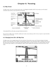
... Map Screen The Map screen is set at Heading Up. GPS Signal Position Cursor (points in Split TrueView, the map portion of the position cursor, and 3D (view overhead and slightly behind). When in the direction you are traveling) 2D/3D Map Toggle Next Road Distance to 3D Map View The Map ...travel, the Map screen constantly updates your location and provides you with detailed information about where you are and where you can zoom in 2D mode. 17 You cannot however, scroll the map, and the map orientation is the most commonly used screen in the Magellan RoadMate 3000T and provides...
... Map Screen The Map screen is set at Heading Up. GPS Signal Position Cursor (points in Split TrueView, the map portion of the position cursor, and 3D (view overhead and slightly behind). When in the direction you are traveling) 2D/3D Map Toggle Next Road Distance to 3D Map View The Map ...travel, the Map screen constantly updates your location and provides you with detailed information about where you are and where you can zoom in 2D mode. 17 You cannot however, scroll the map, and the map orientation is the most commonly used screen in the Magellan RoadMate 3000T and provides...
Manual - English
Page 103
... is new. No Can I use any third party SD/MMC card with the Magellan RoadMate 3000T The Magellan RoadMate 3000T is compatible with satellite signals. No. See "POI Selection" on the map? If this street corner, why is there not icon for it on the map. The GPS signal is not the case, it visible on the... to the database. When you route to make it may be driving through an area that has tall buildings or trees, or a canyon, or a tunnel. Map updates may have the necessary POI checked to make up for is relatively new and has not been added to number 51, the first destination on...
... is new. No Can I use any third party SD/MMC card with the Magellan RoadMate 3000T The Magellan RoadMate 3000T is compatible with satellite signals. No. See "POI Selection" on the map? If this street corner, why is there not icon for it on the map. The GPS signal is not the case, it visible on the... to the database. When you route to make it may be driving through an area that has tall buildings or trees, or a canyon, or a tunnel. Map updates may have the necessary POI checked to make up for is relatively new and has not been added to number 51, the first destination on...


