Manual - Danish
Page 101
... 03 04 05 06 07 08 09 10 11 12 13 14 Anden side Kurs 0 Hastighed 0,0 m/s Aktuel bredde: 34.10939 N Aktuel længde:117,82599 W GPS-version: Aktuel højde 255 TTFF 116s #Satellit (U/T) 11/12 PDOP 2.3 VDOP 1.7 TTFF 0.0 HDOP 1.3 FOMS P/V/H 2 UTC TIME 08/16/2004 22:56:53 PRN 27V...
... 03 04 05 06 07 08 09 10 11 12 13 14 Anden side Kurs 0 Hastighed 0,0 m/s Aktuel bredde: 34.10939 N Aktuel længde:117,82599 W GPS-version: Aktuel højde 255 TTFF 116s #Satellit (U/T) 11/12 PDOP 2.3 VDOP 1.7 TTFF 0.0 HDOP 1.3 FOMS P/V/H 2 UTC TIME 08/16/2004 22:56:53 PRN 27V...

Manual - English
Page 5
... Satellite Navigation ...2 How Satellite Navigation Works ...2 Line of Sight ...2 A Word on the Safe Usage of GPS Maps ...3 From Source to Destination...3 Placement of Your GPS Receiver for Optimal Satellite Reception ...3 Signal Acquisition Time ...3 GPS Maps and Your Safety ...4 Chapter 3: Magellan RoadMate 3000T ...5 Front View ...5 Rear View ...6 Top View ...6 Bottom View ...7 Right Side View ...7 Left Side View...
... Satellite Navigation ...2 How Satellite Navigation Works ...2 Line of Sight ...2 A Word on the Safe Usage of GPS Maps ...3 From Source to Destination...3 Placement of Your GPS Receiver for Optimal Satellite Reception ...3 Signal Acquisition Time ...3 GPS Maps and Your Safety ...4 Chapter 3: Magellan RoadMate 3000T ...5 Front View ...5 Rear View ...6 Top View ...6 Bottom View ...7 Right Side View ...7 Left Side View...
Manual - English
Page 7
...60 TrueView Options ...60 Select Map Color...60 Route Preferences...61 Detour Options...62 Menu Colors...63 Tone Options...63 GPS Options...63 GPS Status ...63 Set GPS Position ...64 Simulator Mode...64 Automatic Volume...65 Backup and Restore...65 Backup ...65 Restore ...65 Map Information ...Audio Test...72 Touchscreen Test ...72 Keypad Test ...72 Video Test ...72 Contact Us ...73 Chapter 11: Magellan RoadMate Tools Installation ...74 Installing the Software ...74 Chapter 12: Magellan RoadMate Music Manager ...75 Chapter 13: Music Player ...76 Single Song Play ...76 Multiple Song Play ...76 iii
...60 TrueView Options ...60 Select Map Color...60 Route Preferences...61 Detour Options...62 Menu Colors...63 Tone Options...63 GPS Options...63 GPS Status ...63 Set GPS Position ...64 Simulator Mode...64 Automatic Volume...65 Backup and Restore...65 Backup ...65 Restore ...65 Map Information ...Audio Test...72 Touchscreen Test ...72 Keypad Test ...72 Video Test ...72 Contact Us ...73 Chapter 11: Magellan RoadMate Tools Installation ...74 Installing the Software ...74 Chapter 12: Magellan RoadMate Music Manager ...75 Chapter 13: Music Player ...76 Single Song Play ...76 Multiple Song Play ...76 iii
Manual - English
Page 8
......82 List View ...82 Thumbnail ...82 Rename ...82 Properties ...83 Tools ...83 Preferences...83 Delete Files ...83 About ...83 Chapter 16: Magellan RoadMate POI Manager ...84 Latitude ...84 Longitude ...84 Altitude ...85 Opening a POI File ...85 Creating a New POI FIle ...86 Adding Individual ... FIle ...88 Appendix ...89 POI Categories ...89 Specifications ...91 PC Requirements ...91 GPS Status Screen ...92 GPS STATUS Screen Structure-first page ...92 Bad fix code ...92 GPS STATUS Screen Structure - second page ...93 Typical GPS STATUS Screen Display ...94 Frequently Asked Questions ...95 iv
......82 List View ...82 Thumbnail ...82 Rename ...82 Properties ...83 Tools ...83 Preferences...83 Delete Files ...83 About ...83 Chapter 16: Magellan RoadMate POI Manager ...84 Latitude ...84 Longitude ...84 Altitude ...85 Opening a POI File ...85 Creating a New POI FIle ...86 Adding Individual ... FIle ...88 Appendix ...89 POI Categories ...89 Specifications ...91 PC Requirements ...91 GPS Status Screen ...92 GPS STATUS Screen Structure-first page ...92 Bad fix code ...92 GPS STATUS Screen Structure - second page ...93 Typical GPS STATUS Screen Display ...94 Frequently Asked Questions ...95 iv
Manual - English
Page 10
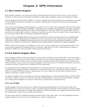
...in a vast number of every position on to at least three satellites and uses the information received to provide improved accuracy. Global Positioning System (GPS) and the Russian GLObal NAvigation Satellite System (GLONASS). These coordinates represent the exact point where... phase in operation: the U.S. Navigation satellite receivers use of additional augmentation systems. While the GPS and GLONASS satellite networks are continuously within line of sight to a wide range of the receiving device. Chapter 2: GPS Information 2.1 About Satellite Navigation Global satellite navigation...
...in a vast number of every position on to at least three satellites and uses the information received to provide improved accuracy. Global Positioning System (GPS) and the Russian GLObal NAvigation Satellite System (GLONASS). These coordinates represent the exact point where... phase in operation: the U.S. Navigation satellite receivers use of additional augmentation systems. While the GPS and GLONASS satellite networks are continuously within line of sight to a wide range of the receiving device. Chapter 2: GPS Information 2.1 About Satellite Navigation Global satellite navigation...
Manual - English
Page 11
... updated the GPS signal status and will receive the satellite fix much faster, but may require an external antenna. Whether topographical maps, roadmaps or marine charts, each map and the data it is clear of the vehicle. We do not create the maps that the products we release work on your Magellan RoadMate 3000T...
... updated the GPS signal status and will receive the satellite fix much faster, but may require an external antenna. Whether topographical maps, roadmaps or marine charts, each map and the data it is clear of the vehicle. We do not create the maps that the products we release work on your Magellan RoadMate 3000T...

Manual - English
Page 12
...medical or other limits; pavement characteristics or conditions; The Magellan GPS receiver must not be used with common sense, and it is an aid to use good judgment while operating the Magellan GPS receiver. construction work zones or hazards; traffic congestion; It ... map data from commercial cartography companies such as Navigation Technologies, Navionics, DMTI and C-Map. 4 For instance, the Magellan RoadMate 3000T GPS receiver should be your situation. Thales Navigation also licenses map data from governmental sources such as weight, height, width, load...
...medical or other limits; pavement characteristics or conditions; The Magellan GPS receiver must not be used with common sense, and it is an aid to use good judgment while operating the Magellan GPS receiver. construction work zones or hazards; traffic congestion; It ... map data from commercial cartography companies such as Navigation Technologies, Navionics, DMTI and C-Map. 4 For instance, the Magellan RoadMate 3000T GPS receiver should be your situation. Thales Navigation also licenses map data from governmental sources such as weight, height, width, load...
Manual - English
Page 25
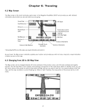
... screen is set at Heading Up. You cannot however, scroll the map, and the map orientation is the most commonly used screen in the Magellan RoadMate 3000T and provides you with not only a map but a visual indication of where you are going. While in 3D Map mode, you can...SmartDetour Icon POI Icon † Planned Route (pink) Current Road Next Maneuver Direction of the position cursor, and 3D (view overhead and slightly behind). GPS Signal Position Cursor (points in and out. The 3D view offers a more realistic view showing a perspective of the screen will be changed between 2D...
... screen is set at Heading Up. You cannot however, scroll the map, and the map orientation is the most commonly used screen in the Magellan RoadMate 3000T and provides you with not only a map but a visual indication of where you are going. While in 3D Map mode, you can...SmartDetour Icon POI Icon † Planned Route (pink) Current Road Next Maneuver Direction of the position cursor, and 3D (view overhead and slightly behind). GPS Signal Position Cursor (points in and out. The 3D view offers a more realistic view showing a perspective of the screen will be changed between 2D...
Manual - English
Page 71
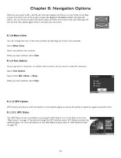
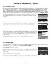
...approach a maneuver, an audible alert sounds to let you once more information on the GPS Status screens refer to "GPS Status Screen" on the screen to have finished, select Save. 8.1.10 GPS Options GPS Options provide you encounter traffic, and the set time has elapsed again when it will...time. 8.1.10.1 GPS Status The GPS Status screen is available by selecting one minute it will stop flashing until the set time has elapsed, the Detour icon will alert you know to make the maneuver. GPS Status monitors the satellite signal. When you have the Magellan RoadMate 3000T calculate the detour...
...approach a maneuver, an audible alert sounds to let you once more information on the GPS Status screens refer to "GPS Status Screen" on the screen to have finished, select Save. 8.1.10 GPS Options GPS Options provide you encounter traffic, and the set time has elapsed again when it will...time. 8.1.10.1 GPS Status The GPS Status screen is available by selecting one minute it will stop flashing until the set time has elapsed, the Detour icon will alert you know to make the maneuver. GPS Status monitors the satellite signal. When you have the Magellan RoadMate 3000T calculate the detour...
Manual - English
Page 72
..., it may take some time for the simulation to the Configuration menu. x1.5 will "drive" at the top of the screen. In order for the Magellan RoadMate 3000T to scroll the list up or down (if necessary) and select the desired city. x2 will be returned to work, you are and will...a route first. Use the Navigation key to the Map screen. Go to scroll the list up the satellite signal acquisition. Chapter 8: Navigation Options 8.1.10.2 Set GPS Position Set GPS Position enables you can demonstrate the capabilities of the Magellan RoadMate 3000T without actually driving.
..., it may take some time for the simulation to the Configuration menu. x1.5 will "drive" at the top of the screen. In order for the Magellan RoadMate 3000T to scroll the list up or down (if necessary) and select the desired city. x2 will be returned to work, you are and will...a route first. Use the Navigation key to the Map screen. Go to scroll the list up the satellite signal acquisition. Chapter 8: Navigation Options 8.1.10.2 Set GPS Position Set GPS Position enables you can demonstrate the capabilities of the Magellan RoadMate 3000T without actually driving.
Manual - English
Page 96
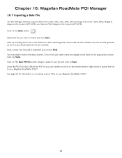
...how the data is separated and click on Finish. Click on Next. Select the POI file you just created and click on Save. GPS Exchange file format (.GPS,.XML); Click on The Save POI file button. Start by choosing which line in the data file to your data file has a ...appropriate column. Click on the Open button . Assign a name to define the data columns. Close the POI File Editor. If your Magellan RoadMate 3000T. You now need to your Magellan RoadMate 3000T. 88 Click on your file and click on the transfer button (right arrow) to upload the file to start at line...
...how the data is separated and click on Finish. Click on Next. Select the POI file you just created and click on Save. GPS Exchange file format (.GPS,.XML); Click on The Save POI file button. Start by choosing which line in the data file to your data file has a ...appropriate column. Click on the Open button . Assign a name to define the data columns. Close the POI File Editor. If your Magellan RoadMate 3000T. You now need to your Magellan RoadMate 3000T. 88 Click on your file and click on the transfer button (right arrow) to upload the file to start at line...
Manual - English
Page 99
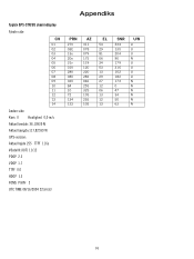
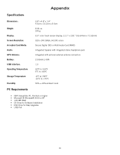
Appendix Specifications DImensions: Weight: Display: Screen Resolution: Accepted Card Media: Audio: GPS Antenna: Battery: USB Interface: Operating Temperature: Storage Temperature: Humidity: PC Requirements 3.8" x 4.8" x 1.4" 9.6cm x 12.2cm x 3.5cm 8.64 oz. 245 g 3.5" color touch screen display, 2.11" x 2.81" (53....
Appendix Specifications DImensions: Weight: Display: Screen Resolution: Accepted Card Media: Audio: GPS Antenna: Battery: USB Interface: Operating Temperature: Storage Temperature: Humidity: PC Requirements 3.8" x 4.8" x 1.4" 9.6cm x 12.2cm x 3.5cm 8.64 oz. 245 g 3.5" color touch screen display, 2.11" x 2.81" (53....
Manual - English
Page 100
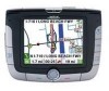
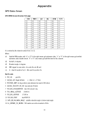
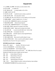
Appendix GPS Status Screen GPS STATUS Screen Structure-first page CH 01 02 03 04 05 06 07 08 09 10 11 12 13 14 PRN d1 d1 d1 d1 ...
Appendix GPS Status Screen GPS STATUS Screen Structure-first page CH 01 02 03 04 05 06 07 08 09 10 11 12 13 14 PRN d1 d1 d1 d1 ...
Manual - English
Page 101
... 2Dinitial fix is good, it would be inverted in map matching) UTC TIME MM/DD/YY HH:MM:SS(UTC time without local zone) 93 GPS STATUS Screen Structure - second page Heading XXX (degree) Speeding XX.X (meter per second) Current Lat: DDD.DDDDD W/E (current latitude, degree) Current Long: DDD.DDDDD N/S (current...
... 2Dinitial fix is good, it would be inverted in map matching) UTC TIME MM/DD/YY HH:MM:SS(UTC time without local zone) 93 GPS STATUS Screen Structure - second page Heading XXX (degree) Speeding XX.X (meter per second) Current Lat: DDD.DDDDD W/E (current latitude, degree) Current Long: DDD.DDDDD N/S (current...

Manual - English
Page 102
Appendix Typical GPS STATUS Screen Display First Page CH 01 02 03 04 05 06 07 08 09 10 11 12 13 14 PRN 27V 03E 13e 20e 31v 01V 28V 08V 02V 84 10 72 134 122 Second Page Heading 0 Speed 0.0 m/s Current Lat: 34.10939 N Current Long:117.82599 W GPS Version: Current altitude 255 TTFF 116s #Satellite (U/T) 11/12 PDOP 2.3 VDOP 1.7 TTFF 0.0 HDOP 1.3 FOMS P/V/H 2 UTC TIME 08/16/2004 22:56:53 AZ 311 078 079 175 119 120 220 282 046 255 325 105 255 105 EL 54 29 81 06 34 53 13 29 27 12 06 13 12 13 SNR 334 135 204 90 179 316 152 182 173 0 47 34 50 63 U/N U U U N U U U U N N N N N N 94
Appendix Typical GPS STATUS Screen Display First Page CH 01 02 03 04 05 06 07 08 09 10 11 12 13 14 PRN 27V 03E 13e 20e 31v 01V 28V 08V 02V 84 10 72 134 122 Second Page Heading 0 Speed 0.0 m/s Current Lat: 34.10939 N Current Long:117.82599 W GPS Version: Current altitude 255 TTFF 116s #Satellite (U/T) 11/12 PDOP 2.3 VDOP 1.7 TTFF 0.0 HDOP 1.3 FOMS P/V/H 2 UTC TIME 08/16/2004 22:56:53 AZ 311 078 079 175 119 120 220 282 046 255 325 105 255 105 EL 54 29 81 06 34 53 13 29 27 12 06 13 12 13 SNR 334 135 204 90 179 316 152 182 173 0 47 34 50 63 U/N U U U N U U U U N N N N N N 94
Manual - English
Page 103
...The GPS signal is weak. Can I import a play MP3's and Route at the same time? Contact Technical Support. These conditions may be driving through an area that has tall buildings or trees, or a canyon, or a tunnel. Check your Magellan RoadMate 3000T to often. The Magellan RoadMate 3000T... uses the most major brands of SD/MMC card. 95 The Magellan RoadMate 3000T uses the latest POI data available. Appendix Frequently Asked Questions Why is my...
...The GPS signal is weak. Can I import a play MP3's and Route at the same time? Contact Technical Support. These conditions may be driving through an area that has tall buildings or trees, or a canyon, or a tunnel. Check your Magellan RoadMate 3000T to often. The Magellan RoadMate 3000T... uses the most major brands of SD/MMC card. 95 The Magellan RoadMate 3000T uses the latest POI data available. Appendix Frequently Asked Questions Why is my...


