Manual - Danish
Page 101
... 03 04 05 06 07 08 09 10 11 12 13 14 Anden side Kurs 0 Hastighed 0,0 m/s Aktuel bredde: 34.10939 N Aktuel længde:117,82599 W GPS-version: Aktuel højde 255 TTFF 116s #Satellit (U/T) 11/12 PDOP 2.3 VDOP 1.7 TTFF 0.0 HDOP 1.3 FOMS P/V/H 2 UTC TIME 08/16/2004 22:56:53 PRN 27V...
... 03 04 05 06 07 08 09 10 11 12 13 14 Anden side Kurs 0 Hastighed 0,0 m/s Aktuel bredde: 34.10939 N Aktuel længde:117,82599 W GPS-version: Aktuel højde 255 TTFF 116s #Satellit (U/T) 11/12 PDOP 2.3 VDOP 1.7 TTFF 0.0 HDOP 1.3 FOMS P/V/H 2 UTC TIME 08/16/2004 22:56:53 PRN 27V...

Manual - English
Page 5
... Satellite Navigation ...2 How Satellite Navigation Works ...2 Line of Sight ...2 A Word on the Safe Usage of GPS Maps ...3 From Source to Destination...3 Placement of Your GPS Receiver for Optimal Satellite Reception ...3 Signal Acquisition Time ...3 GPS Maps and Your Safety ...4 Chapter 3: Magellan RoadMate 3000T ...5 Front View ...5 Rear View ...6 Top View ...6 Bottom View ...7 Right Side View ...7 Left Side View...
... Satellite Navigation ...2 How Satellite Navigation Works ...2 Line of Sight ...2 A Word on the Safe Usage of GPS Maps ...3 From Source to Destination...3 Placement of Your GPS Receiver for Optimal Satellite Reception ...3 Signal Acquisition Time ...3 GPS Maps and Your Safety ...4 Chapter 3: Magellan RoadMate 3000T ...5 Front View ...5 Rear View ...6 Top View ...6 Bottom View ...7 Right Side View ...7 Left Side View...
Manual - English
Page 7
...60 TrueView Options ...60 Select Map Color...60 Route Preferences...61 Detour Options...62 Menu Colors...63 Tone Options...63 GPS Options...63 GPS Status ...63 Set GPS Position ...64 Simulator Mode...64 Automatic Volume...65 Backup and Restore...65 Backup ...65 Restore ...65 Map Information ...Audio Test...72 Touchscreen Test ...72 Keypad Test ...72 Video Test ...72 Contact Us ...73 Chapter 11: Magellan RoadMate Tools Installation ...74 Installing the Software ...74 Chapter 12: Magellan RoadMate Music Manager ...75 Chapter 13: Music Player ...76 Single Song Play ...76 Multiple Song Play ...76 iii
...60 TrueView Options ...60 Select Map Color...60 Route Preferences...61 Detour Options...62 Menu Colors...63 Tone Options...63 GPS Options...63 GPS Status ...63 Set GPS Position ...64 Simulator Mode...64 Automatic Volume...65 Backup and Restore...65 Backup ...65 Restore ...65 Map Information ...Audio Test...72 Touchscreen Test ...72 Keypad Test ...72 Video Test ...72 Contact Us ...73 Chapter 11: Magellan RoadMate Tools Installation ...74 Installing the Software ...74 Chapter 12: Magellan RoadMate Music Manager ...75 Chapter 13: Music Player ...76 Single Song Play ...76 Multiple Song Play ...76 iii
Manual - English
Page 8
second page ...93 Typical GPS STATUS Screen Display ...94 Frequently Asked Questions ...95 iv TABLE OF CONTENTS Play...77 Create...77 Modify...77 Delete ...77 Rename ...78 Play Mode ...78 List Songs ...78 Equalizer ...79 Help ...79 Chapter 14: Magellan RoadMate Photo Manager ...80 Chapter 15...Photos ...82 List View ...82 Thumbnail ...82 Rename ...82 Properties ...83 Tools ...83 Preferences...83 Delete Files ...83 About ...83 Chapter 16: Magellan RoadMate POI Manager ...84 Latitude ...84 Longitude ...84 Altitude ...85 Opening a POI File ...85 Creating a New POI FIle ...86 Adding Individual POI...
second page ...93 Typical GPS STATUS Screen Display ...94 Frequently Asked Questions ...95 iv TABLE OF CONTENTS Play...77 Create...77 Modify...77 Delete ...77 Rename ...78 Play Mode ...78 List Songs ...78 Equalizer ...79 Help ...79 Chapter 14: Magellan RoadMate Photo Manager ...80 Chapter 15...Photos ...82 List View ...82 Thumbnail ...82 Rename ...82 Properties ...83 Tools ...83 Preferences...83 Delete Files ...83 About ...83 Chapter 16: Magellan RoadMate POI Manager ...84 Latitude ...84 Longitude ...84 Altitude ...85 Opening a POI File ...85 Creating a New POI FIle ...86 Adding Individual POI...
Manual - English
Page 10
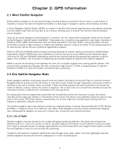
... tool to enhance your recreational and industrial activities. 2.2.1 Line of Sight Satellite-navigation receivers operate by line of sight with the use of additional augmentation systems. While the GPS and GLONASS satellite networks are constantly being developed in Europe specifically to provide a higher... Systems (SBAS) have been established to calculate altitude. The distance of the receiver from the satellites and the time they orbit Earth in establishing the required integrity for GPS and GLONASS transmissions with global-positioning satellites. This means that can be picked ...
... tool to enhance your recreational and industrial activities. 2.2.1 Line of Sight Satellite-navigation receivers operate by line of sight with the use of additional augmentation systems. While the GPS and GLONASS satellite networks are constantly being developed in Europe specifically to provide a higher... Systems (SBAS) have been established to calculate altitude. The distance of the receiver from the satellites and the time they orbit Earth in establishing the required integrity for GPS and GLONASS transmissions with global-positioning satellites. This means that can be picked ...
Manual - English
Page 11
... presents is not affected by reflective coatings on our GPS devices. External conditions also affect GPS signal reception. depending on a regular basis to place the receiver in scale: the smaller the scale, the more . Therefore, when using in your explorations and to have your Magellan RoadMate 3000T, or if you travel over 500 miles with...
... presents is not affected by reflective coatings on our GPS devices. External conditions also affect GPS signal reception. depending on a regular basis to place the receiver in scale: the smaller the scale, the more . Therefore, when using in your explorations and to have your Magellan RoadMate 3000T, or if you travel over 500 miles with...

Manual - English
Page 12
... all traffic laws, including pedestrian observance of crosswalks, and to use good judgment while operating the Magellan GPS receiver. The Magellan GPS receiver must be operated only by vehicle passengers or by your situation. special events; For instance, the Magellan RoadMate 3000T GPS receiver should be used while engaged in any unsafe, hazardous or illegal route suggestions. It must not...
... all traffic laws, including pedestrian observance of crosswalks, and to use good judgment while operating the Magellan GPS receiver. The Magellan GPS receiver must be operated only by vehicle passengers or by your situation. special events; For instance, the Magellan RoadMate 3000T GPS receiver should be used while engaged in any unsafe, hazardous or illegal route suggestions. It must not...
Manual - English
Page 25
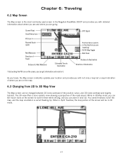
...the map, and the map orientation is the most commonly used screen in Split TrueView, the map portion of the roads ahead. When in the Magellan RoadMate 3000T and provides you with not only a map but a visual indication of where you can still touch icons on the map. 6.3 Changing from...As you travel, the Map screen constantly updates your location and provides you with detailed information about where you are and where you are going. GPS Signal Position Cursor (points in 2D mode. 17 Chapter 6: Traveling 6.2 Map Screen The Map screen is set at Heading Up. Current Road ...
...the map, and the map orientation is the most commonly used screen in Split TrueView, the map portion of the roads ahead. When in the Magellan RoadMate 3000T and provides you with not only a map but a visual indication of where you can still touch icons on the map. 6.3 Changing from...As you travel, the Map screen constantly updates your location and provides you with detailed information about where you are and where you are going. GPS Signal Position Cursor (points in 2D mode. 17 Chapter 6: Traveling 6.2 Map Screen The Map screen is set at Heading Up. Current Road ...
Manual - English
Page 71
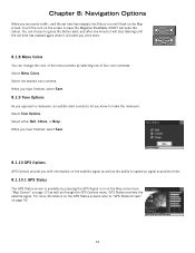
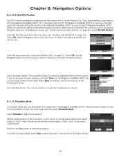
... when it will flash on the screen to have finished, select Save. 8.1.10 GPS Options GPS Options provide you once more information on the GPS Status screens refer to speed up signal acquisition time. 8.1.10.1 GPS Status The GPS Status screen is available by selecting one minute it will stop flashing until the set.... Select the desired color scheme. You can change the color of four color schemes. and after one of the menu screens by pressing the GPS Signal icon on the Map screen (see "Map Screen" on page 92. 63 When you have the Magellan RoadMate 3000T calculate the detour.
... when it will flash on the screen to have finished, select Save. 8.1.10 GPS Options GPS Options provide you once more information on the GPS Status screens refer to speed up signal acquisition time. 8.1.10.1 GPS Status The GPS Status screen is available by selecting one minute it will stop flashing until the set.... Select the desired color scheme. You can change the color of four color schemes. and after one of the menu screens by pressing the GPS Signal icon on the Map screen (see "Map Screen" on page 92. 63 When you have the Magellan RoadMate 3000T calculate the detour.
Manual - English
Page 72
... at one and a half times normal speed; x2 will "drive" at two times normal speed. Select Set GPS Position. If you can demonstrate the capabilities of the Magellan RoadMate 3000T without actually driving. You will use the lowest number in by pressing the Globe button on the Destination screen... Mode In Simulator Mode, you do not know the exact address, just select Done and the Magellan RoadMate 3000T will be returned to the Configuration menu. Chapter 8: Navigation Options 8.1.10.2 Set GPS Position Set GPS Position enables you are and will "drive" at the top of the screen.
... at one and a half times normal speed; x2 will "drive" at two times normal speed. Select Set GPS Position. If you can demonstrate the capabilities of the Magellan RoadMate 3000T without actually driving. You will use the lowest number in by pressing the Globe button on the Destination screen... Mode In Simulator Mode, you do not know the exact address, just select Done and the Magellan RoadMate 3000T will be returned to the Configuration menu. Chapter 8: Navigation Options 8.1.10.2 Set GPS Position Set GPS Position enables you are and will "drive" at the top of the screen.
Manual - English
Page 96
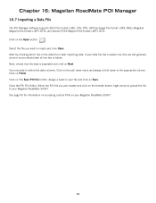
...click on the Open button . Close the POI File Editor. Chapter 16: Magellan RoadMate POI Manager 16.7 Importing a Data FIle The POI Manager software supports ASCII file format (.ASC,.CSV,.TXT); GPS Exchange file format (.GPS,.XML); Select the file you just created and click on Finish. Click on... the transfer button (right arrow) to upload the file to import and click Open. If your Magellan RoadMate 3000T. Select the POI file you ...
...click on the Open button . Close the POI File Editor. Chapter 16: Magellan RoadMate POI Manager 16.7 Importing a Data FIle The POI Manager software supports ASCII file format (.ASC,.CSV,.TXT); GPS Exchange file format (.GPS,.XML); Select the file you just created and click on Finish. Click on... the transfer button (right arrow) to upload the file to import and click Open. If your Magellan RoadMate 3000T. Select the POI file you ...
Manual - English
Page 99
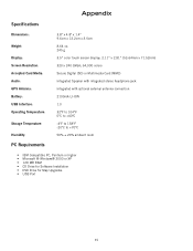
Appendix Specifications DImensions: Weight: Display: Screen Resolution: Accepted Card Media: Audio: GPS Antenna: Battery: USB Interface: Operating Temperature: Storage Temperature: Humidity: PC Requirements 3.8" x 4.8" x 1.4" 9.6cm x 12.2cm x 3.5cm 8.64 oz. 245 g 3.5" color touch screen display, 2.11" x 2.81" (53....
Appendix Specifications DImensions: Weight: Display: Screen Resolution: Accepted Card Media: Audio: GPS Antenna: Battery: USB Interface: Operating Temperature: Storage Temperature: Humidity: PC Requirements 3.8" x 4.8" x 1.4" 9.6cm x 12.2cm x 3.5cm 8.64 oz. 245 g 3.5" color touch screen display, 2.11" x 2.81" (53....
Manual - English
Page 100
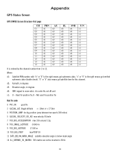
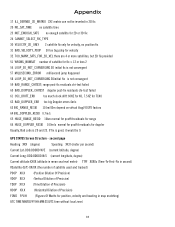
... m 10 TOO_BIG_PDOP max PDOP 50 11 SATS_BELOW_MASK_ANGLE satellite elevation angle is ordered by the channel number from 1 to 12. Used for this channel. Appendix GPS Status Screen GPS STATUS Screen Structure-first page CH 01 02 03 04 05 06 07 08 09 10 11 12 13 14 PRN d1 d1 d1...
... m 10 TOO_BIG_PDOP max PDOP 50 11 SATS_BELOW_MASK_ANGLE satellite elevation angle is ordered by the channel number from 1 to 12. Used for this channel. Appendix GPS Status Screen GPS STATUS Screen Structure-first page CH 01 02 03 04 05 06 07 08 09 10 11 12 13 14 PRN d1 d1 d1...
Manual - English
Page 101
... Dilution of Precision) TDOP XX.X (Time Dilution of Precision) HDOP XX.X (Horizontal Dilution of satellite for doppler Usually, Bad code is not convergent 59 BAD_RANGE_CHITEST; GPS STATUS Screen Structure - second page Heading XXX (degree) Speeding XX.X (meter per second) Current Lat: DDD.DDDDD W/E (current latitude, degree) Current Long: DDD.DDDDD N/S (current...
... Dilution of Precision) TDOP XX.X (Time Dilution of Precision) HDOP XX.X (Horizontal Dilution of satellite for doppler Usually, Bad code is not convergent 59 BAD_RANGE_CHITEST; GPS STATUS Screen Structure - second page Heading XXX (degree) Speeding XX.X (meter per second) Current Lat: DDD.DDDDD W/E (current latitude, degree) Current Long: DDD.DDDDD N/S (current...

Manual - English
Page 102
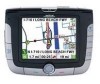
Appendix Typical GPS STATUS Screen Display First Page CH 01 02 03 04 05 06 07 08 09 10 11 12 13 14 PRN 27V 03E 13e 20e 31v 01V 28V 08V 02V 84 10 72 134 122 Second Page Heading 0 Speed 0.0 m/s Current Lat: 34.10939 N Current Long:117.82599 W GPS Version: Current altitude 255 TTFF 116s #Satellite (U/T) 11/12 PDOP 2.3 VDOP 1.7 TTFF 0.0 HDOP 1.3 FOMS P/V/H 2 UTC TIME 08/16/2004 22:56:53 AZ 311 078 079 175 119 120 220 282 046 255 325 105 255 105 EL 54 29 81 06 34 53 13 29 27 12 06 13 12 13 SNR 334 135 204 90 179 316 152 182 173 0 47 34 50 63 U/N U U U N U U U U N N N N N N 94
Appendix Typical GPS STATUS Screen Display First Page CH 01 02 03 04 05 06 07 08 09 10 11 12 13 14 PRN 27V 03E 13e 20e 31v 01V 28V 08V 02V 84 10 72 134 122 Second Page Heading 0 Speed 0.0 m/s Current Lat: 34.10939 N Current Long:117.82599 W GPS Version: Current altitude 255 TTFF 116s #Satellite (U/T) 11/12 PDOP 2.3 VDOP 1.7 TTFF 0.0 HDOP 1.3 FOMS P/V/H 2 UTC TIME 08/16/2004 22:56:53 AZ 311 078 079 175 119 120 220 282 046 255 325 105 255 105 EL 54 29 81 06 34 53 13 29 27 12 06 13 12 13 SNR 334 135 204 90 179 316 152 182 173 0 47 34 50 63 U/N U U U N U U U U N N N N N N 94
Manual - English
Page 103
...street corner, why is there not icon for it may be a problem with the antenna. See "Chapter 16: Magellan RoadMate POI Manager" on page 84., and "Custom POIs" on page 55. Wait a few moments and the signal ... are the POI you are looking for those you get better as more satellites are , your Magellan RoadMate 3000T to make it visible on the list is removed and each successive destination is moved up....MMC card. 95 Chances are acquired. Map updates may be made available once per year. The GPS signal is weak. What's going on the map? If the problem persists, there may have the...
...street corner, why is there not icon for it may be a problem with the antenna. See "Chapter 16: Magellan RoadMate POI Manager" on page 84., and "Custom POIs" on page 55. Wait a few moments and the signal ... are the POI you are looking for those you get better as more satellites are , your Magellan RoadMate 3000T to make it visible on the list is removed and each successive destination is moved up....MMC card. 95 Chances are acquired. Map updates may be made available once per year. The GPS signal is weak. What's going on the map? If the problem persists, there may have the...


