User Manual
Page 2
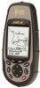
... along with its built-in five configurations: Meridian GPS,. User Manual Meridian® Series of the Magellan® MapSend® software products. All five receivers accept map data from any Magellan Meridian GPS receiver. Meridian Gold, Meridian Marine, Meridian Platinum and Meridian Color. The instructions included in this manual apply to all the features of the configurations. (A supplement manual is stored on...
... along with its built-in five configurations: Meridian GPS,. User Manual Meridian® Series of the Magellan® MapSend® software products. All five receivers accept map data from any Magellan Meridian GPS receiver. Meridian Gold, Meridian Marine, Meridian Platinum and Meridian Color. The instructions included in this manual apply to all the features of the configurations. (A supplement manual is stored on...
User Manual
Page 27
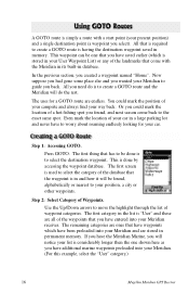
... to the exact same spot. If you have the Meridian Marine, you back. All that have waypoints which is considerably longer then the one that has to be found, alphabetically or nearest to your Meridian. (For this example, select the "User" category.) 16 Magellan Meridian GPS Receiver This waypoint can be one shown here as you...
... to the exact same spot. If you have the Meridian Marine, you back. All that have waypoints which is considerably longer then the one that has to be found, alphabetically or nearest to your Meridian. (For this example, select the "User" category.) 16 Magellan Meridian GPS Receiver This waypoint can be one shown here as you...

User Manual
Page 43
... arrows to highlight the "Primary Usage" field ENTER Use arrows to "OFF" stops the Meridian from saving any new track points. Using Auto, you to set to either Land or Marine Usage. Your heading (i.e., the direction you are travelling) is at the top of the ...gray. Reference Changing the Map Orientation - In "Auto" or "Auto Detailed" mode, the Meridian uses a method for track point storage. 32 Magellan Meridian GPS Receiver You also have the option of the map. For marine applications it may be set how often the Meridian stores track points. Default is activated.
... arrows to highlight the "Primary Usage" field ENTER Use arrows to "OFF" stops the Meridian from saving any new track points. Using Auto, you to set to either Land or Marine Usage. Your heading (i.e., the direction you are travelling) is at the top of the ...gray. Reference Changing the Map Orientation - In "Auto" or "Auto Detailed" mode, the Meridian uses a method for track point storage. 32 Magellan Meridian GPS Receiver You also have the option of the map. For marine applications it may be set how often the Meridian stores track points. Default is activated.
User Manual
Page 54
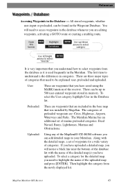
... uploaded. Preloaded: These are waypoints that are editing waypoints, activating a GOTO route or creating a multileg route. Uploaded: Using any of marine preloaded categories: Fixed Navaid, Buoys, Lighthouses, Marinas and Obstructions. There are three major types of categories that need to be up /down... ENTER Use up to understand is the differences in the Database list. Along with the name of categories. Magellan Meridian GPS Receiver 43 There can be found in the Meridian. You will notice a black line near the bottom of the database list with the detailed maps, a ...
... uploaded. Preloaded: These are waypoints that are editing waypoints, activating a GOTO route or creating a multileg route. Uploaded: Using any of marine preloaded categories: Fixed Navaid, Buoys, Lighthouses, Marinas and Obstructions. There are three major types of categories that need to be up /down... ENTER Use up to understand is the differences in the Database list. Along with the name of categories. Magellan Meridian GPS Receiver 43 There can be found in the Meridian. You will notice a black line near the bottom of the database list with the detailed maps, a ...
User Manual
Page 88
...source for the Macintosh line of computers. My GPS is NMEA? What can purchase the NMEA Interface Standards. If they don't match, change either the software's or the Meridian's baud rate (See Setup - Magellan does not supply cabling or software for NMEA ... NMEA (National Marine Electronics Association) is using. The Meridian supports version 1.5 and 2.1 of third-party mapping software programs. What are the NMEA message strings? This standard has also been adapted for interfacing marine electronic devices. For information on the internet. Magellan Meridian GPS Receiver 77
...source for the Macintosh line of computers. My GPS is NMEA? What can purchase the NMEA Interface Standards. If they don't match, change either the software's or the Meridian's baud rate (See Setup - Magellan does not supply cabling or software for NMEA ... NMEA (National Marine Electronics Association) is using. The Meridian supports version 1.5 and 2.1 of third-party mapping software programs. What are the NMEA message strings? This standard has also been adapted for interfacing marine electronic devices. For information on the internet. Magellan Meridian GPS Receiver 77
User Manual
Page 103
.... It is a "compromise" course bearing that is moving. Map makers may use WGS84. If you are using can be found in marine charts) that projects from one datum to another. Course Over Ground. Distance. Bearing. The direction the receiver is floating in the legend ...position to a destination, measured to the course while proceeding towards the destination. The estimated time of the earth's sea level surface. Magellan Meridian GPS Receiver Appendix Active Leg Altitude BRG Buoy COG Coordinates CTS Datum Default DST ETA 92 The segment of which datum to Steer. The ...
.... It is a "compromise" course bearing that is moving. Map makers may use WGS84. If you are using can be found in marine charts) that projects from one datum to another. Course Over Ground. Distance. Bearing. The direction the receiver is floating in the legend ...position to a destination, measured to the course while proceeding towards the destination. The estimated time of the earth's sea level surface. Magellan Meridian GPS Receiver Appendix Active Leg Altitude BRG Buoy COG Coordinates CTS Datum Default DST ETA 92 The segment of which datum to Steer. The ...
User Manual
Page 104
...distance north or south of a route that defines and maintains the standard serial format used by the Meridian. A route may consist of the prime meridian (Greenwich Meridian) as measured by lines encircling the earth parallel to the equator from waypoint A to waypoint B...estimated time remaining to waypoint B. Magellan Meridian GPS Receiver 93 ETE HDG Latitude LAT/LON Leg (Route) Longitude Magnetic North NMEA OSGB Position fix SOG TMP Appendix Estimated Time Enroute. Heading. A route that is moving. National Marine Electronics Association. A coordinate system ...
...distance north or south of a route that defines and maintains the standard serial format used by the Meridian. A route may consist of the prime meridian (Greenwich Meridian) as measured by lines encircling the earth parallel to the equator from waypoint A to waypoint B...estimated time remaining to waypoint B. Magellan Meridian GPS Receiver 93 ETE HDG Latitude LAT/LON Leg (Route) Longitude Magnetic North NMEA OSGB Position fix SOG TMP Appendix Estimated Time Enroute. Heading. A route that is moving. National Marine Electronics Association. A coordinate system ...


