
iGo Primo
Page 4
... route 50 3.4.1 Selecting a new destination when already having a route: New Route, Waypoint or Final Destination...50 3.4.2 Setting a new starting position for the route 51 3.4.3 Editing the list of destinations (Edit Route 52 3.4.4 Pausing the active route 53 3.4.5 Cancelling the active route 53 3.4.6 Checking route alternatives when planning the route 53 3.4.7 Checking route alternatives for an existing route 54 3.4.8 Changing the vehicle used in route planning 56 3.4.9 Changing the road types used in route planning 56 3.5 Saving a location as a Favourite destination 57 3.6 Saving...
... route 50 3.4.1 Selecting a new destination when already having a route: New Route, Waypoint or Final Destination...50 3.4.2 Setting a new starting position for the route 51 3.4.3 Editing the list of destinations (Edit Route 52 3.4.4 Pausing the active route 53 3.4.5 Cancelling the active route 53 3.4.6 Checking route alternatives when planning the route 53 3.4.7 Checking route alternatives for an existing route 54 3.4.8 Changing the vehicle used in route planning 56 3.4.9 Changing the road types used in route planning 56 3.5 Saving a location as a Favourite destination 57 3.6 Saving...

iGo Primo
Page 8
... your route, setting a start point for the route, picking route alternatives, avoiding parts of the route, simulating navigation or adding the destination to your Favourites. Tap to customise the way the navigation software works, to simulate demo routes or to run some of your destination by entering an address or selecting a place of interest, a location on the map. You only need to confirm selections or changes if the application needs to restart, it once. 2.1 Navigation menu You...
... your route, setting a start point for the route, picking route alternatives, avoiding parts of the route, simulating navigation or adding the destination to your Favourites. Tap to customise the way the navigation software works, to simulate demo routes or to run some of your destination by entering an address or selecting a place of interest, a location on the map. You only need to confirm selections or changes if the application needs to restart, it once. 2.1 Navigation menu You...
iGo Primo
Page 13
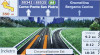
... always displayed in Settings. If roads are asked to travel on information available for route calculation and the navigation mode. However, this icon in the top left corner of menu screens.) Default data fields when navigating a route (tap and hold any of receiving live traffic information, the calculation takes into account traffic delays affecting your exact GPS position and heading. Shows the current time corrected with the Vehimarker. The exact location of receiving live traffic information...
... always displayed in Settings. If roads are asked to travel on information available for route calculation and the navigation mode. However, this icon in the top left corner of menu screens.) Default data fields when navigating a route (tap and hold any of receiving live traffic information, the calculation takes into account traffic delays affecting your exact GPS position and heading. Shows the current time corrected with the Vehimarker. The exact location of receiving live traffic information...
iGo Primo
Page 22
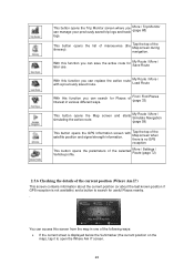
... the current street is no GPS reception This button opens Vehicle profile. screen and starts My Route / More / Simulate Navigation (page 59) This button opens the GPS Information screen satellite position and signal strength information. the parameters of the selected More / Settings / Route (page 72) 2.3.6 Checking the details of the current position (Where Am I?) This screen contains information about the current position (or about the last known position if GPS reception is not available) and a button to...
... the current street is no GPS reception This button opens Vehicle profile. screen and starts My Route / More / Simulate Navigation (page 59) This button opens the GPS Information screen satellite position and signal strength information. the parameters of the selected More / Settings / Route (page 72) 2.3.6 Checking the details of the current position (Where Am I?) This screen contains information about the current position (or about the last known position if GPS reception is not available) and a button to...
iGo Primo
Page 24
... set a new starting the search with the product. You can also use iGO primo for off the GPS receiver and set up your destination (page 33). Select a location on Map feature (page 43). Use a previously saved Favourite destination (page 44). Select a location from the History of previously used destinations (page 46). Enter the coordinate of the destination (page 47). 3.1.1 Entering an address or a part of the address If you do not need to turn...
... set a new starting the search with the product. You can also use iGO primo for off the GPS receiver and set up your destination (page 33). Select a location on Map feature (page 43). Use a previously saved Favourite destination (page 44). Select a location from the History of previously used destinations (page 46). Enter the coordinate of the destination (page 47). 3.1.1 Entering an address or a part of the address If you do not need to turn...

iGo Primo
Page 50
... save a future trip. Tap to display the entire route on your current location. This can also set a route start point other than your route. The symbol of the vehicle type used in the above sections, the application will ask you already have the following sections show some of those options. 3.4.1 Selecting a new destination when already having a route: New Route, Waypoint or Final Destination If you whether to start a new route, add a new waypoint (intermediate destination...
... save a future trip. Tap to display the entire route on your current location. This can also set a route start point other than your route. The symbol of the vehicle type used in the above sections, the application will ask you already have the following sections show some of those options. 3.4.1 Selecting a new destination when already having a route: New Route, Waypoint or Final Destination If you whether to start a new route, add a new waypoint (intermediate destination...
iGo Primo
Page 69
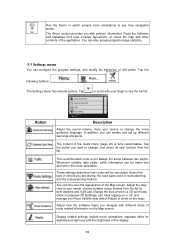
... type of vehicle you with your finger to see how navigation works. Button Description Adjust the sound volume, mute your needs, choose suitable colour themes from the list. You can enable and set up different warnings and alerts. Display related settings include menu animations, separate skins for both daytime and night use and the brightness of iGO primo. Tap the following buttons: , The Settings menu has several options. Whenever suitable data exists, traffic information...
... type of vehicle you with your finger to see how navigation works. Button Description Adjust the sound volume, mute your needs, choose suitable colour themes from the list. You can enable and set up different warnings and alerts. Display related settings include menu animations, separate skins for both daytime and night use and the brightness of iGO primo. Tap the following buttons: , The Settings menu has several options. Whenever suitable data exists, traffic information...
iGo Primo
Page 70
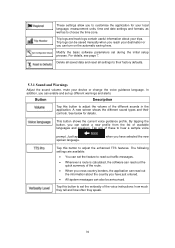
... destination or you can read out traffic messages. Whenever a route is calculated, the software can enable and set during the initial setup process. The following settings are available: You can be announced. Trip logs and track logs contain useful information about the country you have just entered. All system messages can also be saved manually when you reach your local language, measurement units, time and date settings and formats...
... destination or you can read out traffic messages. Whenever a route is calculated, the software can enable and set during the initial setup process. The following settings are available: You can be announced. Trip logs and track logs contain useful information about the country you have just entered. All system messages can also be saved manually when you reach your local language, measurement units, time and date settings and formats...

iGo Primo
Page 72
... situations and vehicle types by turn by changing the planning method. If the selected routing method is a preference. You can also set the type of the selected vehicle profile, or you can even create new vehicle profiles if you can have your destination can quickly switch to navigate between two points. The route calculation can receive real-time traffic information. Button Description You can set the minimum delay that can be accessed using the road network on...
... situations and vehicle types by turn by changing the planning method. If the selected routing method is a preference. You can also set the type of the selected vehicle profile, or you can even create new vehicle profiles if you can have your destination can quickly switch to navigate between two points. The route calculation can receive real-time traffic information. Button Description You can set the minimum delay that can be accessed using the road network on...

iGo Primo
Page 74
... helps in Regional Settings. Vehicle types: When creating a new vehicle profile, select one of arrival. : Manoeuvre restrictions and directional constraints (if they are inevitable to bicycles in Regional Settings. Set the maximum speed you travel cost calculation. The unit for consumption can also be set in the map data) are taken into account when planning a route. Roads are used only if access for cars is allowed. 74 Enter...
... helps in Regional Settings. Vehicle types: When creating a new vehicle profile, select one of arrival. : Manoeuvre restrictions and directional constraints (if they are inevitable to bicycles in Regional Settings. Set the maximum speed you travel cost calculation. The unit for consumption can also be set in the map data) are taken into account when planning a route. Roads are used only if access for cars is allowed. 74 Enter...

iGo 8
Page 5
... entering its coordinates 37 3.2 Creating a multi-point route (inserting a via point 37 3.3 Creating a multi-point route (appending a new destination 38 3.4 Editing the route ...39 3.5 Watching the simulation of the route 39 3.6 Pausing the active route ...39 3.7 Deleting the next via point from the route 40 3.8 Deleting the active route ...40 3.9 Saving a route...40 3.10 Loading a saved route ...41 4 Reference Guide ...41 4.1 Map screen ...42 4.1.1 Icons on the map ...45 4.1.1.1 GPS position quality indicator ...45 4.1.1.2 Status indicator strip ...46 4.1.1.3 Next two route events (Turn...
... entering its coordinates 37 3.2 Creating a multi-point route (inserting a via point 37 3.3 Creating a multi-point route (appending a new destination 38 3.4 Editing the route ...39 3.5 Watching the simulation of the route 39 3.6 Pausing the active route ...39 3.7 Deleting the next via point from the route 40 3.8 Deleting the active route ...40 3.9 Saving a route...40 3.10 Loading a saved route ...41 4 Reference Guide ...41 4.1 Map screen ...42 4.1.1 Icons on the map ...45 4.1.1.1 GPS position quality indicator ...45 4.1.1.2 Status indicator strip ...46 4.1.1.3 Next two route events (Turn...

iGo 8
Page 22
... • a POI • a map marker Pin 2.3.2.4 Original position in a route • the destination of a route You can use the Cursor • the start point of a route • a via point in the Cursor menu When the Cursor menu is open, a special icon ( was opened with a radiating red dot ( ) to make it visible at the selected point on the map. • a POI • a map marker Pin 2.3.2.2 Returning to normal navigation When GPS position is available, and...
... • a POI • a map marker Pin 2.3.2.4 Original position in a route • the destination of a route You can use the Cursor • the start point of a route • a via point in the Cursor menu When the Cursor menu is open, a special icon ( was opened with a radiating red dot ( ) to make it visible at the selected point on the map. • a POI • a map marker Pin 2.3.2.2 Returning to normal navigation When GPS position is available, and...

iGo 8
Page 30
... times on the same road. The procedure is restarted at some point. If needed , change the settlement: To select the settlement from the list of recently used ones, tap the button. Get to select the appropriate address by the district/suburb information. Enter the house number: Tap . Enter the house number on the keyboard. Tap the following buttons: , . To enter a new settlement: Tap the button with the selected point in the middle. The map...
... times on the same road. The procedure is restarted at some point. If needed , change the settlement: To select the settlement from the list of recently used ones, tap the button. Get to select the appropriate address by the district/suburb information. Enter the house number: Tap . Enter the house number on the keyboard. Tap the following buttons: , . To enter a new settlement: Tap the button with the selected point in the middle. The map...

iGo 8
Page 34
... important intersection. Tap the button. Find below an example with a full address: The procedure is explained starting from the list of recently used ones, tap the button. Tap the following buttons: , . By default, M-NV proposes the country/state and settlement where you have chosen. Tap the following buttons: , . 33 If needed , change the settlement: To select the settlement from the Navigation menu. The map appears with the name...
... important intersection. Tap the button. Find below an example with a full address: The procedure is explained starting from the list of recently used ones, tap the button. Tap the following buttons: , . By default, M-NV proposes the country/state and settlement where you have chosen. Tap the following buttons: , . 33 If needed , change the settlement: To select the settlement from the Navigation menu. The map appears with the name...
iGo 8
Page 42
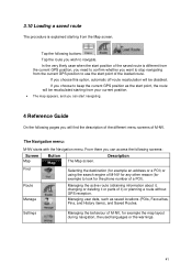
... current GPS position as saved locations (POIs, Favourites, Pins, and History items), and Saved Routes. Managing the active route (obtaining information about it, changing or deleting it or parts of it) or planning a route without GPS reception. From there you can start navigating. 4 Reference Guide On the following pages you will be disabled. Tap the following screens: Screen Map Button The Map screen. Managing user data, such as the start point, the route will find the description of the different menu screens of M-NV...
... current GPS position as saved locations (POIs, Favourites, Pins, and History items), and Saved Routes. Managing the active route (obtaining information about it, changing or deleting it or parts of it) or planning a route without GPS reception. From there you can start navigating. 4 Reference Guide On the following pages you will be disabled. Tap the following screens: Screen Map Button The Map screen. Managing user data, such as the start point, the route will find the description of the different menu screens of M-NV...

iGo 8
Page 53
... a new screen opens, and the route is demoted, and becomes the last via point. The Cursor becomes the start point. Select the POI group and give a name for the POI, then select a suitable icon, enter a phone number, and additional information if you follow the recommended route on the map. Map locations can give a name for the Favourite. 4.1.5 Position menu When you like. This button is similar to open the Position menu, tap . 4.1.6 Route Information screen...
... a new screen opens, and the route is demoted, and becomes the last via point. The Cursor becomes the start point. Select the POI group and give a name for the POI, then select a suitable icon, enter a phone number, and additional information if you follow the recommended route on the map. Map locations can give a name for the Favourite. 4.1.5 Position menu When you like. This button is similar to open the Position menu, tap . 4.1.6 Route Information screen...

iGo 8
Page 61
... above you have already entered in M-NV are used by entering its coordinates. Select the destination of POIs included with M-NV or from the ones you , with your destination by the GPS receiver to find the location. . Icon Sky view circle Colour Name n/a Coordinates n/a Status bar for the green satellites. The satellites are for the satellites 4.2 Find menu Description The virtual sky shows the visible part of the address, this is your routes.
... above you have already entered in M-NV are used by entering its coordinates. Select the destination of POIs included with M-NV or from the ones you , with your destination by the GPS receiver to find the location. . Icon Sky view circle Colour Name n/a Coordinates n/a Status bar for the green satellites. The satellites are for the satellites 4.2 Find menu Description The virtual sky shows the visible part of the address, this is your routes.

iGo 8
Page 70
... a pass or vignette to use certain roads or to enter certain areas. M-NV includes ferries in a route with fewer turns. Usually the best selection for slow vehicles. This button shows the current voice guidance profile. Button Program Language Voice Profile Description This button displays the current written language of temporary ferries. Type Charge roads Permit needed Ferries Cross-border planning Description Charge roads are asked to confirm this option, you can make MNV to take, for...
... a pass or vignette to use certain roads or to enter certain areas. M-NV includes ferries in a route with fewer turns. Usually the best selection for slow vehicles. This button shows the current voice guidance profile. Button Program Language Voice Profile Description This button displays the current written language of temporary ferries. Type Charge roads Permit needed Ferries Cross-border planning Description Charge roads are asked to confirm this option, you can make MNV to take, for...
iGo 8
Page 75
... map database pertaining thereto and any third-party content and services accessible through the Software Product (hereinafter: Database). 4.3 Any form of display, storage, coding, including printed, electronic or graphic display, storage, source or object code, or any other as yet undefined form of display, storage, or coding, or any medium thereof shall be deemed parts of the Software Product. 4.4 Error corrections, additions, updates used by the User following...
... map database pertaining thereto and any third-party content and services accessible through the Software Product (hereinafter: Database). 4.3 Any form of display, storage, coding, including printed, electronic or graphic display, storage, source or object code, or any other as yet undefined form of display, storage, or coding, or any medium thereof shall be deemed parts of the Software Product. 4.4 Error corrections, additions, updates used by the User following...

iGo 8
Page 76
... whole or in part), to separate it into one hardware device (desktop, handheld, portable computer, navigation device), and to run and use the contents available through the Software Product and provided by third parties and the data received through technological or by any reason; 7.1.3 to translate the Software Product (including translation (compilation) to other programming languages); 7.1.4 to decompile the Software Product; 7.1.5 to evade...
... whole or in part), to separate it into one hardware device (desktop, handheld, portable computer, navigation device), and to run and use the contents available through the Software Product and provided by third parties and the data received through technological or by any reason; 7.1.3 to translate the Software Product (including translation (compilation) to other programming languages); 7.1.4 to decompile the Software Product; 7.1.5 to evade...


