Owners Manual
Page 1
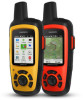
INREACH SE®+ INREACH EXPLORER®+ Owner's Manual
INREACH SE®+ INREACH EXPLORER®+ Owner's Manual
Owners Manual
Page 8
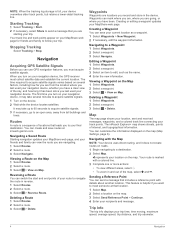
...at that you turn on your trip time, time moving, maximum speed, average speed, trip distance, and trip odometer. 4 Navigation The inReach Explorer+ map shows streets, points of the sky, and how long it may take several minutes to acquire satellite signals. 1 Turn on ... your navigation device, the GPS receiver must acquire satellite signals. NOTE: When the tracking log storage is helpful if you want to meet someone at inreach.garmin.com. Starting Tracking 1 Select Tracking > Start. 2 If necessary, select Share to a Waypoint 1 Select Waypoints. 2 Select a waypoint. 3 ...
...at that you turn on your trip time, time moving, maximum speed, average speed, trip distance, and trip odometer. 4 Navigation The inReach Explorer+ map shows streets, points of the sky, and how long it may take several minutes to acquire satellite signals. 1 Turn on ... your navigation device, the GPS receiver must acquire satellite signals. NOTE: When the tracking log storage is helpful if you want to meet someone at inreach.garmin.com. Starting Tracking 1 Select Tracking > Start. 2 If necessary, select Share to a Waypoint 1 Select Waypoints. 2 Select a waypoint. 3 ...
Owners Manual
Page 9
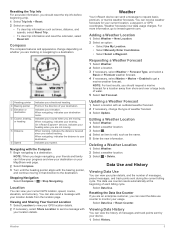
... bearing, Ã or heading Distance Ä Speed Å Indicates your speed. NOTE: When you are tracking or navigating to inreach.garmin.com. For more information, go to a destination. Data Use and History Viewing Data Use You can receive weather forecasts for a ...Location. 2 Select an option: • Select Use My Location. • Select Manually Enter Coordinates. • Select Select a Waypoint. On inReach Explorer+ devices, indicates your usage. You can view your course when you should request a marine forecast for your location details from shore and over ...
... bearing, Ã or heading Distance Ä Speed Å Indicates your speed. NOTE: When you are tracking or navigating to inreach.garmin.com. For more information, go to a destination. Data Use and History Viewing Data Use You can receive weather forecasts for a ...Location. 2 Select an option: • Select Use My Location. • Select Manually Enter Coordinates. • Select Select a Waypoint. On inReach Explorer+ devices, indicates your usage. You can view your course when you should request a marine forecast for your location details from shore and over ...
Owners Manual
Page 10
... Device: Connects your device with your location and updates the track line on the device. Navigating to distance or ratio. Compass and Altimeter Settings Your inReach Explorer+ device was calibrated at which the device logs your MapShare link when you to send a message with a compatible Bluetooth enabled mobile device.
... Device: Connects your device with your location and updates the track line on the device. Navigating to distance or ratio. Compass and Altimeter Settings Your inReach Explorer+ device was calibrated at which the device logs your MapShare link when you to send a message with a compatible Bluetooth enabled mobile device.