
Quick Reference Guide
Page 1
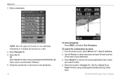
... an MOB: 1. Select a destination. 4. Select Back to save the new location. To move the waypoint on the screen to view the 50 nearest destinations that contain your current location as a waypoint or as an MOB point. Select the button for a Destination by Name. 2. Select...Press SELECT to the destination. Select Create Waypoint. Follow the colored line on the Navigation chart: 1. OR Select Guide To when using a preprogrammed BlueChart® g2 Vision® card to designate as a waypoint. 3. From the Home screen, select Where To?. 2. From any screen, press MARK. 2. ...
... an MOB: 1. Select a destination. 4. Select Back to save the new location. To move the waypoint on the screen to view the 50 nearest destinations that contain your current location as a waypoint or as an MOB point. Select the button for a Destination by Name. 2. Select...Press SELECT to the destination. Select Create Waypoint. Follow the colored line on the Navigation chart: 1. OR Select Guide To when using a preprogrammed BlueChart® g2 Vision® card to designate as a waypoint. 3. From the Home screen, select Where To?. 2. From any screen, press MARK. 2. ...

Owner's Manual
Page 2
... or stored in the USA and other Garmin products. Except as expressly provided herein, no part of Garmin. Visit the Garmin Web site (www.garmin.com) for any person or organization of Garmin Ltd. Garmin®, the Garmin logo, GPSMAP®, BlueChart®, g2 Vision®, and MapSource® are ...content without notice. NMEA 2000® and the NMEA 2000 logo are registered trademarks of Garmin. or its subsidiaries. All rights reserved. Garmin hereby grants permission to notify any purpose without the express permission of the National Maritime Electronics Association.
... or stored in the USA and other Garmin products. Except as expressly provided herein, no part of Garmin. Visit the Garmin Web site (www.garmin.com) for any person or organization of Garmin Ltd. Garmin®, the Garmin logo, GPSMAP®, BlueChart®, g2 Vision®, and MapSource® are ...content without notice. NMEA 2000® and the NMEA 2000 logo are registered trademarks of Garmin. or its subsidiaries. All rights reserved. Garmin hereby grants permission to notify any purpose without the express permission of the National Maritime Electronics Association.
Owner's Manual
Page 4
... of Contents Introduction i Tips and Shortcuts i Manual Conventions i Quick Links i Declaration of Conformity (DoC iv Product Registration iv Contact Garmin iv Getting Started 1 Unit Overview 1 Turning the Unit On or Off 2 Initializing Unit Settings 2 Adjusting the Backlight 3 Using the... Navigating to a Destination 23 Creating and Using Waypoints 25 Creating and Using Routes 26 Using Tracks 28 Using BlueChart g2 Vision 30 Navigating with a Garmin Autopilot 30 Viewing Information 31 Viewing a Compass 31 Viewing Numbers 31 Viewing Trip Information 32 Viewing and Customizing...
... of Contents Introduction i Tips and Shortcuts i Manual Conventions i Quick Links i Declaration of Conformity (DoC iv Product Registration iv Contact Garmin iv Getting Started 1 Unit Overview 1 Turning the Unit On or Off 2 Initializing Unit Settings 2 Adjusting the Backlight 3 Using the... Navigating to a Destination 23 Creating and Using Waypoints 25 Creating and Using Routes 26 Using Tracks 28 Using BlueChart g2 Vision 30 Navigating with a Garmin Autopilot 30 Viewing Information 31 Viewing a Compass 31 Viewing Numbers 31 Viewing Trip Information 32 Viewing and Customizing...
Owner's Manual
Page 11
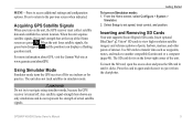
...screen when indicated. GPSMAP 400/500 Series Owner's Manual 5 Using Simulator Mode Simulator mode turns the GPS receiver off . Insert optional BlueChart® g2 Vision® SD cards to set speed, track control, and position. To insert the SD card, open the access door and press.... From the Home screen, select Configure > System > Simulator. 2. When the unit acquires satellite signals, the signal strength bars at www.garmin.com/aboutGPS. The unit does not track satellites in simulator mode. Warning Do not try to access additional settings and configuration options....
...screen when indicated. GPSMAP 400/500 Series Owner's Manual 5 Using Simulator Mode Simulator mode turns the GPS receiver off . Insert optional BlueChart® g2 Vision® SD cards to set speed, track control, and position. To insert the SD card, open the access door and press.... From the Home screen, select Configure > System > Simulator. 2. When the unit acquires satellite signals, the signal strength bars at www.garmin.com/aboutGPS. The unit does not track satellites in simulator mode. Warning Do not try to access additional settings and configuration options....
Owner's Manual
Page 12
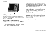
...31). • Configure-access unit and system settings (page 48). 6 GPSMAP 400/500 Series Owner's Manual Getting Started Note: If you use a BlueChart g2 Vision SD card or if your built-in map supports Fishing charts. • Sonar-set up and access sonar information (page 57). Note: Mariner's ...waypoints from any screen to return to use a BlueChart g2 Vision SD card. Press HOME from MapSource® or HomePort™, update to the most-current version by clicking Help > Check for Software Updates, or check the Garmin Web site at www.garmin.com. Note: You must have an "s" series ...
...31). • Configure-access unit and system settings (page 48). 6 GPSMAP 400/500 Series Owner's Manual Getting Started Note: If you use a BlueChart g2 Vision SD card or if your built-in map supports Fishing charts. • Sonar-set up and access sonar information (page 57). Note: Mariner's ...waypoints from any screen to return to use a BlueChart g2 Vision SD card. Press HOME from MapSource® or HomePort™, update to the most-current version by clicking Help > Check for Software Updates, or check the Garmin Web site at www.garmin.com. Note: You must have an "s" series ...
Owner's Manual
Page 13
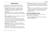
...zoom levels of the chart with enhanced bottom contours and without navigational data. Note: If you are available if you must insert an optional BlueChart g2 Vision preprogrammed SD card to view detailed Navigation and Mariner's Eye charts. Fishing charts are using a GPSMAP 421, 521, or 526 ...(including "s" models), you use a BlueChart g2 Vision SD card. Using Charts • Mariner's Eye 3D-provides a view from the Home screen, select Charts > Navigation Chart. Using the Navigation...
...zoom levels of the chart with enhanced bottom contours and without navigational data. Note: If you are available if you must insert an optional BlueChart g2 Vision preprogrammed SD card to view detailed Navigation and Mariner's Eye charts. Fishing charts are using a GPSMAP 421, 521, or 526 ...(including "s" models), you use a BlueChart g2 Vision SD card. Using Charts • Mariner's Eye 3D-provides a view from the Home screen, select Charts > Navigation Chart. Using the Navigation...
Owner's Manual
Page 15
... wind angle. • Compass Tape-displayed at the top of the screen to provide the current heading, and an indicator that follow the standards for BlueChart g2 and BlueChart g2 Vision use graphic symbols to show on the cruising data bar. • Fishing-turn the Depth, Water Temperature, and Water Speed data bar on...
... wind angle. • Compass Tape-displayed at the top of the screen to provide the current heading, and an indicator that follow the standards for BlueChart g2 and BlueChart g2 Vision use graphic symbols to show on the cruising data bar. • Fishing-turn the Depth, Water Temperature, and Water Speed data bar on...
Owner's Manual
Page 16
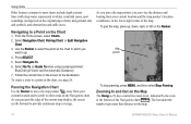
... on the Navigation chart. Map pointer To stop panning, press MENU, and then select Stop Panning. Select Go To (or Guide To when using a preprogrammed BlueChart g2 Vision card for Automatic Guidance). 7. From the Home screen, select Charts. 2. Panning the Navigation Chart Use the Rocker to move the map pointer, you can...
... on the Navigation chart. Map pointer To stop panning, press MENU, and then select Stop Panning. Select Go To (or Guide To when using a preprogrammed BlueChart g2 Vision card for Automatic Guidance). 7. From the Home screen, select Charts. 2. Panning the Navigation Chart Use the Rocker to move the map pointer, you can...
Owner's Manual
Page 17
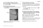
... icon showing the relevant tide level. If more information about on the chart (page 20). For more than one item is only available while using a BlueChart g2 Vision SD card.
... icon showing the relevant tide level. If more information about on the chart (page 20). For more than one item is only available while using a BlueChart g2 Vision SD card.

Owner's Manual
Page 19
... card and you want to see what area the maps cover. • Photo Points-turns camera icons (page 20) on or off when using a BlueChart g2 Vision card)-identifies a selected depth. Safety Shading (only available when you reach the end of the heading line. Using Charts Symbols-changes symbol preferences. &#...World Map-displays a basic world map or satellite imagery (when Full World Map is always drawn at, or deeper than the specified value are using a BlueChart g2 Vision SD card. • Vehicle Icon-allows you to the end of the heading line. • Time-sets the amount of interest) on or...
... card and you want to see what area the maps cover. • Photo Points-turns camera icons (page 20) on or off when using a BlueChart g2 Vision card)-identifies a selected depth. Safety Shading (only available when you reach the end of the heading line. Using Charts Symbols-changes symbol preferences. &#...World Map-displays a basic world map or satellite imagery (when Full World Map is always drawn at, or deeper than the specified value are using a BlueChart g2 Vision SD card. • Vehicle Icon-allows you to the end of the heading line. • Time-sets the amount of interest) on or...

Owner's Manual
Page 20
... a visual navigation aid. Press the Range (-) key to move the view closer to the navaid. To view details about the navaid. Split Navigation Chart (with a BlueChart g2 Vision card) The top half of the screen is zoomed in unfamiliar harbors or anchorages. GPSMAP 400/500 Series Owner's Manual
... a visual navigation aid. Press the Range (-) key to move the view closer to the navaid. To view details about the navaid. Split Navigation Chart (with a BlueChart g2 Vision card) The top half of the screen is zoomed in unfamiliar harbors or anchorages. GPSMAP 400/500 Series Owner's Manual
Owner's Manual
Page 21
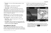
... (page 9). This view is helpful when navigating tricky shoals, reefs, bridges, or channels, and is beneficial when trying to the water. Using Mariner's Eye 3D A BlueChart g2 Vision SD card offers Mariner's Eye 3D that have been saved. Other Vessels-view information about other vessels. This setting also affects routes (Route To...
... (page 9). This view is helpful when navigating tricky shoals, reefs, bridges, or channels, and is beneficial when trying to the water. Using Mariner's Eye 3D A BlueChart g2 Vision SD card offers Mariner's Eye 3D that have been saved. Other Vessels-view information about other vessels. This setting also affects routes (Route To...

Owner's Manual
Page 23
Using Fish Eye 3D Using the depth contour lines of the BlueChart g2 Vision cartography, Fish Eye 3D provides an underwater view of the course line drawn when navigating. View-selects a fish eye view (Fore, Aft, Port, or ...
Using Fish Eye 3D Using the depth contour lines of the BlueChart g2 Vision cartography, Fish Eye 3D provides an underwater view of the course line drawn when navigating. View-selects a fish eye view (Fore, Aft, Port, or ...

Owner's Manual
Page 24
.... The higher you set the percentage, the more the satellite photos will cover both portions of the Navigation chart when using a preprogrammed BlueChart g2 Vision SD card. While viewing the Navigation chart, press MENU. 2. Using Charts The Fishing chart uses detailed bathymetric data on a preprogrammed... BlueChart g2 Vision SD card, and is shown on water with photos overlaying the land. • On-photos overlay both the water and the ...
.... The higher you set the percentage, the more the satellite photos will cover both portions of the Navigation chart when using a preprogrammed BlueChart g2 Vision SD card. While viewing the Navigation chart, press MENU. 2. Using Charts The Fishing chart uses detailed bathymetric data on a preprogrammed... BlueChart g2 Vision SD card, and is shown on water with photos overlaying the land. • On-photos overlay both the water and the ...
Owner's Manual
Page 25
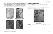
Use these photos to help orient yourself to your BlueChart g2 Vision region, either zoom in further using the Range (+) key, or set the detail level higher (page 12). Photo Overlay Off Land Only Photo Overlay Photo Overlay at 50% Photo Overlay at lower zoom levels. If you cannot ...see the high-resolution images in your surroundings or to acquaint yourself with a marina or a harbor prior to arrival. Using Charts Viewing Aerial Photos Preprogrammed BlueChart g2 Vision SD cards contain aerial ...
Use these photos to help orient yourself to your BlueChart g2 Vision region, either zoom in further using the Range (+) key, or set the detail level higher (page 12). Photo Overlay Off Land Only Photo Overlay Photo Overlay at 50% Photo Overlay at lower zoom levels. If you cannot ...see the high-resolution images in your surroundings or to acquaint yourself with a marina or a harbor prior to arrival. Using Charts Viewing Aerial Photos Preprogrammed BlueChart g2 Vision SD cards contain aerial ...

Owner's Manual
Page 26
... arrow. A red arrow pointing downward indicates a falling tide, and a blue arrow pointing upward indicates a rising tide. You must be available in your preloaded map or BlueChart g2 Vision region. Tide Station with the pointer, and select Aerial Photo or Review. Using Charts To access aerial photos from the Navigation chart: Use the...
... arrow. A red arrow pointing downward indicates a falling tide, and a blue arrow pointing upward indicates a rising tide. You must be available in your preloaded map or BlueChart g2 Vision region. Tide Station with the pointer, and select Aerial Photo or Review. Using Charts To access aerial photos from the Navigation chart: Use the...
Owner's Manual
Page 27
...on how to use Automatic Guidance. GPSMAP 400/500 Series Owner's Manual 21 section on page 23 has additional information on available BlueChart g2 Vision chart information. The color of the current arrow indicates the range of interest (POI) data, which includes highly detailed ...To?" See page 50 for instructions on searching for your boat. For instructions on setting up Automatic Guidance for , and navigating to, these POIs, see the "Where To?" section beginning on the chart. When you that location. Detailed Road and POI Data BlueChart g2 Vision contains detailed...
...on how to use Automatic Guidance. GPSMAP 400/500 Series Owner's Manual 21 section on page 23 has additional information on available BlueChart g2 Vision chart information. The color of the current arrow indicates the range of interest (POI) data, which includes highly detailed ...To?" See page 50 for instructions on searching for your boat. For instructions on setting up Automatic Guidance for , and navigating to, these POIs, see the "Where To?" section beginning on the chart. When you that location. Detailed Road and POI Data BlueChart g2 Vision contains detailed...
Owner's Manual
Page 29
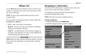
...waypoints, routes, tracks, and services such as nearby fuel, repairs, and ramps. Use the Where To? You can navigate to a destination using a BlueChart g2 Vision SD card for , and navigate to , waypoints, routes, tracks, and services such as nearby fuel, repairs, and ramps. Where To? option ... navigation. For safety, always resolve any discrepancies or questions before you to add turns to the route. • Guide To-uses BlueChart g2 Vision chart data to suggest the best path to navigate. Where To? The chartplotter contains information about thousands of three methods: Go ...
...waypoints, routes, tracks, and services such as nearby fuel, repairs, and ramps. Use the Where To? You can navigate to a destination using a BlueChart g2 Vision SD card for , and navigate to , waypoints, routes, tracks, and services such as nearby fuel, repairs, and ramps. Where To? option ... navigation. For safety, always resolve any discrepancies or questions before you to add turns to the route. • Guide To-uses BlueChart g2 Vision chart data to suggest the best path to navigate. Where To? The chartplotter contains information about thousands of three methods: Go ...
Owner's Manual
Page 30
...50 nearest destinations that contain your destination. 3. Press SELECT to select characters and spell at least a portion of the name of your search criteria. 4. From the Home screen, select Where To? > Search by name: 1. To search for a destination by Name. 2. Select Go To. OR Select Guide To when using a preprogrammed BlueChart g2... Vision card). Select the location > Navigate To > Go To or Route To (or Guide To when using a preprogrammed BlueChart g2 Vision card to the destination. 24 To stop navigating...
...50 nearest destinations that contain your destination. 3. Press SELECT to select characters and spell at least a portion of the name of your search criteria. 4. From the Home screen, select Where To? > Search by name: 1. To search for a destination by Name. 2. Select Go To. OR Select Guide To when using a preprogrammed BlueChart g2... Vision card). Select the location > Navigate To > Go To or Route To (or Guide To when using a preprogrammed BlueChart g2 Vision card to the destination. 24 To stop navigating...
Owner's Manual
Page 33
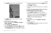
... List, select the first waypoint on the screen, allowing you want to start the new route. To create a route using Automatic Guidance (when using a preprogrammed BlueChart g2 Vision card): 1. The automatic guidance path stays on the route. You can change the automatic guidance path to edit. 3. To create a route in another location...
... List, select the first waypoint on the screen, allowing you want to start the new route. To create a route using Automatic Guidance (when using a preprogrammed BlueChart g2 Vision card): 1. The automatic guidance path stays on the route. You can change the automatic guidance path to edit. 3. To create a route in another location...


