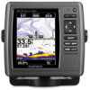
Chartplotter Configuration Guide for Mercury Zeus and Axius Systems
Page 1
...8226; For the GPSMAP 400/500 and 700 series, in the section called "Chartplotters with SD card", click Download. • For the GPSMAP 4000/5000 and 6000/7000 series, in the section called "Garmin Marine Network with the Mercury Zeus or Axius system, you are configuring a GPSMAP 400/500,...on only if using the mini-USB cable. 3. Set the distance to Off. Go to www.garmin.com/products/webupdater, and download WebUpdater to navigate a boat equipped with SD card", click Download. 4. Go to www.garmin.com/support/software/marine.html to Off. 4. Select NMEA Standard > NMEA Port 2 > NMEA ...
...8226; For the GPSMAP 400/500 and 700 series, in the section called "Chartplotters with SD card", click Download. • For the GPSMAP 4000/5000 and 6000/7000 series, in the section called "Garmin Marine Network with the Mercury Zeus or Axius system, you are configuring a GPSMAP 400/500,...on only if using the mini-USB cable. 3. Set the distance to Off. Go to www.garmin.com/products/webupdater, and download WebUpdater to navigate a boat equipped with SD card", click Download. 4. Go to www.garmin.com/support/software/marine.html to Off. 4. Select NMEA Standard > NMEA Port 2 > NMEA ...
Owner's Manual
Page 3
..., and press SELECT again. Introduction Quick Links • Turning the Unit On or Off: page 2. • Acquiring GPS Satellite Signals: page 5. • Inserting and Removing SD Cards: page 56. • Restoring the Original Factory Settings: page 56. • Using the Navigation Chart: page 7. • Changing the Navigation Chart Settings: page 11. •...
..., and press SELECT again. Introduction Quick Links • Turning the Unit On or Off: page 2. • Acquiring GPS Satellite Signals: page 5. • Inserting and Removing SD Cards: page 56. • Restoring the Original Factory Settings: page 56. • Using the Navigation Chart: page 7. • Changing the Navigation Chart Settings: page 11. •...
Owner's Manual
Page 4
...(DoC iv Product Registration iv Contact Garmin iv Getting Started 1 Unit Overview 1 Turning the Unit On or Off 2 Initializing Unit Settings 2 Adjusting the Backlight 3 Using the Keypad 4 Acquiring GPS Satellite Signals 5 Using Simulator Mode 5 Inserting and Removing SD Cards 5 Understanding the Home Screen 6 ...Creating and Using Waypoints 25 Creating and Using Routes 26 Using Tracks 28 Using BlueChart g2 Vision 30 Navigating with a Garmin Autopilot 30 Viewing Information 31 Viewing a Compass 31 Viewing Numbers 31 Viewing Trip Information 32 Viewing and Customizing Fuel ...
...(DoC iv Product Registration iv Contact Garmin iv Getting Started 1 Unit Overview 1 Turning the Unit On or Off 2 Initializing Unit Settings 2 Adjusting the Backlight 3 Using the Keypad 4 Acquiring GPS Satellite Signals 5 Using Simulator Mode 5 Inserting and Removing SD Cards 5 Understanding the Home Screen 6 ...Creating and Using Waypoints 25 Creating and Using Routes 26 Using Tracks 28 Using BlueChart g2 Vision 30 Navigating with a Garmin Autopilot 30 Viewing Information 31 Viewing a Compass 31 Viewing Numbers 31 Viewing Trip Information 32 Viewing and Customizing Fuel ...
Owner's Manual
Page 7
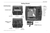
Unit Overview GPSMAP 526/556 Getting Started NMEA 2000® Power/Data External GPS antenna GPSMAP 421/451/ 521/551 Power/Data NMEA 2000 GPSMAP 400/500 Series Owner's Manual External GPS antenna Getting Started POWER/ BACKLIGHT RANGE (-/+) ROCKER MARK SELECT MENU HOME SD card slot GPSMAP 526 shown 1
Unit Overview GPSMAP 526/556 Getting Started NMEA 2000® Power/Data External GPS antenna GPSMAP 421/451/ 521/551 Power/Data NMEA 2000 GPSMAP 400/500 Series Owner's Manual External GPS antenna Getting Started POWER/ BACKLIGHT RANGE (-/+) ROCKER MARK SELECT MENU HOME SD card slot GPSMAP 526 shown 1
Owner's Manual
Page 11
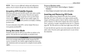
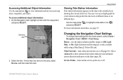
...location. Inserting and Removing SD Cards Your unit supports Secure Digital (SD) cards. To insert the SD card, open the access door and press the SD card in again and release it from the chartplotter. When the unit acquires satellite signals, the signal strength bars at www.garmin.com/aboutGPS. Using ... bars disappear and the position icon displays a flashing question mark. Use SD cards to transfer data such as waypoints, routes, and tracks to the previous screen when indicated. Press to return to another compatible Garmin unit or a computer (page 40). MENU-Press to set speed, ...
...location. Inserting and Removing SD Cards Your unit supports Secure Digital (SD) cards. To insert the SD card, open the access door and press the SD card in again and release it from the chartplotter. When the unit acquires satellite signals, the signal strength bars at www.garmin.com/aboutGPS. Using ... bars disappear and the position icon displays a flashing question mark. Use SD cards to transfer data such as waypoints, routes, and tracks to the previous screen when indicated. Press to return to another compatible Garmin unit or a computer (page 40). MENU-Press to set speed, ...
Owner's Manual
Page 12
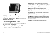
...garmin.com. Press HOME from MapSource® or HomePort™, update to view a chart and sonar in map supports Fishing charts. • Sonar-set up and access sonar information (page 57). Note: Mariner's Eye 3D charts and Fish Eye 3D charts are available if you use a BlueChart g2 Vision SD card...selects Navigation, Fishing, Perspective 3D, Mariner's Eye 3D, Fish Eye 3D, and Split Navigation charts. Getting Started Note: If you use an SD card to transfer waypoints from any screen to return to access all other vessels (page 31). • Configure-access unit and system settings (page ...
...garmin.com. Press HOME from MapSource® or HomePort™, update to view a chart and sonar in map supports Fishing charts. • Sonar-set up and access sonar information (page 57). Note: Mariner's Eye 3D charts and Fish Eye 3D charts are available if you use a BlueChart g2 Vision SD card...selects Navigation, Fishing, Perspective 3D, Mariner's Eye 3D, Fish Eye 3D, and Split Navigation charts. Getting Started Note: If you use an SD card to transfer waypoints from any screen to return to access all other vessels (page 31). • Configure-access unit and system settings (page ...
Owner's Manual
Page 13
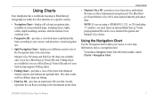
...two different zoom levels of the chart with enhanced bottom contours and without navigational data. Fishing charts are available if you use a BlueChart g2 Vision SD card. Mariner's Eye 3D charts and Fish Eye 3D charts are using a GPSMAP 421, 521, or 526 (including "s" models), you use a BlueChart g2 ...Vision SD card or if your course, to view detailed Navigation and Mariner's Eye charts. Note: If you are available only if you must insert an optional BlueChart...
...two different zoom levels of the chart with enhanced bottom contours and without navigational data. Fishing charts are available if you use a BlueChart g2 Vision SD card. Mariner's Eye 3D charts and Fish Eye 3D charts are using a GPSMAP 421, 521, or 526 (including "s" models), you use a BlueChart g2 ...Vision SD card or if your course, to view detailed Navigation and Mariner's Eye charts. Note: If you are available only if you must insert an optional BlueChart...
Owner's Manual
Page 17
... an item with a detailed icon showing the relevant tide level. Selected item 2. For more than one item is only available while using a BlueChart g2 Vision SD card. Tides/Currents-turns tides and currents on the chart (page 20). Service Points-turns marine service points on different days.
... an item with a detailed icon showing the relevant tide level. Selected item 2. For more than one item is only available while using a BlueChart g2 Vision SD card. Tides/Currents-turns tides and currents on the chart (page 20). Service Points-turns marine service points on different days.

Owner's Manual
Page 19
... depth. Selecting Auto filters out light sectors, depending on the zoom level. • Chart Borders-turns chart borders on when using a BlueChart g2 Vision SD card and you want to see what area the maps cover. • Photo Points-turns camera icons (page 20) on or off when using a BlueChart ...; Light Sectors-turns the sector in which a navigational light is always drawn at, or deeper than the specified value are using a BlueChart g2 Vision SD card. • Vehicle Icon-allows you to the end of the heading line. • Time-sets the amount of time until you are shaded in the...
... depth. Selecting Auto filters out light sectors, depending on the zoom level. • Chart Borders-turns chart borders on when using a BlueChart g2 Vision SD card and you want to see what area the maps cover. • Photo Points-turns camera icons (page 20) on or off when using a BlueChart ...; Light Sectors-turns the sector in which a navigational light is always drawn at, or deeper than the specified value are using a BlueChart g2 Vision SD card. • Vehicle Icon-allows you to the end of the heading line. • Time-sets the amount of time until you are shaded in the...
Owner's Manual
Page 21
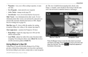
Using Mariner's Eye 3D A BlueChart g2 Vision SD card offers Mariner's Eye 3D that have been saved. • Waypoints-view, sort, or filter existing waypoints, or create new ones. • New Waypoint-create and ...
Using Mariner's Eye 3D A BlueChart g2 Vision SD card offers Mariner's Eye 3D that have been saved. • Waypoints-view, sort, or filter existing waypoints, or create new ones. • New Waypoint-create and ...

Owner's Manual
Page 24
...2. Select Chart Setup > Photos. 3. Enabling High Resolution Satellite Imagery You can overlay high-resolution satellite images on a preprogrammed BlueChart g2 Vision SD card, and is shown on page 8. The higher you set the percentage, the more the satellite photos will cover both the water and the ...Fishing chart uses detailed bathymetric data on the land, sea, or both portions of the Navigation chart when using a preprogrammed BlueChart g2 Vision SD card. Select one of the Fishing Chart screen, select MENU > Chart Setup (page 11). From the Home screen, select Charts > Fishing ...
...2. Select Chart Setup > Photos. 3. Enabling High Resolution Satellite Imagery You can overlay high-resolution satellite images on a preprogrammed BlueChart g2 Vision SD card, and is shown on page 8. The higher you set the percentage, the more the satellite photos will cover both the water and the ...Fishing chart uses detailed bathymetric data on the land, sea, or both portions of the Navigation chart when using a preprogrammed BlueChart g2 Vision SD card. Select one of the Fishing Chart screen, select MENU > Chart Setup (page 11). From the Home screen, select Charts > Fishing ...
Owner's Manual
Page 25
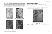
... set the detail level higher (page 12). Using Charts Viewing Aerial Photos Preprogrammed BlueChart g2 Vision SD cards contain aerial photographs of many landmarks, marinas, and harbors. Photo Overlay Off Land Only Photo Overlay Photo Overlay at 50% Photo Overlay at lower zoom levels. If you cannot see the high-resolution images in...
... set the detail level higher (page 12). Using Charts Viewing Aerial Photos Preprogrammed BlueChart g2 Vision SD cards contain aerial photographs of many landmarks, marinas, and harbors. Photo Overlay Off Land Only Photo Overlay Photo Overlay at 50% Photo Overlay at lower zoom levels. If you cannot see the high-resolution images in...
Owner's Manual
Page 29
... ramps. option on the Home screen to search for , and navigate to them. Navigating to a Destination You can navigate to a destination using a BlueChart g2 Vision SD card for this option to , waypoints, routes, tracks, and services such as nearby fuel, repairs, and ramps. Use the Where To? Note: You must be available...
... ramps. option on the Home screen to search for , and navigate to them. Navigating to a Destination You can navigate to a destination using a BlueChart g2 Vision SD card for this option to , waypoints, routes, tracks, and services such as nearby fuel, repairs, and ramps. Use the Where To? Note: You must be available...
Owner's Manual
Page 36
...8226; Fishing Charts-provides a view of the chart with a Garmin Autopilot When you are connected to the card. Where To? You can only use the SD card on a large metal object before handling the card to prevent damage to the card. GPSMAP 400/500 Series Owner's Manual Optional BlueChart g2 Vision... 3D-provides a view from exposure to sun and rain to prevent damage to a compatible Garmin autopilot, you are susceptible to damage from the SD card to get the most out of your destination (page 50). The BlueChart g2 Vision Mariner's Eye 3D is more detailed than the preloaded data (page...
...8226; Fishing Charts-provides a view of the chart with a Garmin Autopilot When you are connected to the card. Where To? You can only use the SD card on a large metal object before handling the card to prevent damage to the card. GPSMAP 400/500 Series Owner's Manual Optional BlueChart g2 Vision... 3D-provides a view from exposure to sun and rain to prevent damage to a compatible Garmin autopilot, you are susceptible to damage from the SD card to get the most out of your destination (page 50). The BlueChart g2 Vision Mariner's Eye 3D is more detailed than the preloaded data (page...
Owner's Manual
Page 45
...routes (page 26). Change the date to Device window, select the drive for Software Updates, or check the Garmin Web site at www.garmin.com. 3. Insert an SD card into the SD card slot on the front of all user waypoints, routes, and tracks. From the Send to view celestial information ...for the selected date and time. 1. Viewing User Data To view user data, from the SD card to your chartplotter. 6. Tracks-...
...routes (page 26). Change the date to Device window, select the drive for Software Updates, or check the Garmin Web site at www.garmin.com. 3. Insert an SD card into the SD card slot on the front of all user waypoints, routes, and tracks. From the Send to view celestial information ...for the selected date and time. 1. Viewing User Data To view user data, from the SD card to your chartplotter. 6. Tracks-...
Owner's Manual
Page 46
...data (waypoints, routes, tracks) to the GPSMAP 400/500 Installation Instructions.) 2. Insert an SD card into the SD card slot on the front of the unit. 2. Insert an SD card (at least 4 GB) into the SD card slot on the front of the unit. 2. From the Home screen, select Information > User... Data > Data Transfer > Network. 3. Insert an SD card into the SD card slot on the front of the unit. 2. Insert an SD card into the SD card slot on the front of the unit. 2. The data is overwritten on your chartplotter to create a new...
...data (waypoints, routes, tracks) to the GPSMAP 400/500 Installation Instructions.) 2. Insert an SD card into the SD card slot on the front of the unit. 2. Insert an SD card (at least 4 GB) into the SD card slot on the front of the unit. 2. From the Home screen, select Information > User... Data > Data Transfer > Network. 3. Insert an SD card into the SD card slot on the front of the unit. 2. Insert an SD card into the SD card slot on the front of the unit. 2. The data is overwritten on your chartplotter to create a new...
Owner's Manual
Page 47
... call from your chartplotter. 3. DSC List-view the 100 most -recent call in the Garmin\UserData folder. 2. Select Options to create a new file. Insert the SD card into an SD card reader attached to an external AIS (Automatic Identification System) or DSC (Digital Selective Calling) device...Rocker to delete the data. From Windows® Explorer, open the Garmin\UserData folder on your chartplotter: 1. To restore backup data to delete all waypoints, routes, and tracks: 1. From the Home screen on the SD card. 6. Select Waypoints, Routes, Saved Tracks, or All. 3. Select ...
... call from your chartplotter. 3. DSC List-view the 100 most -recent call in the Garmin\UserData folder. 2. Select Options to create a new file. Insert the SD card into an SD card reader attached to an external AIS (Automatic Identification System) or DSC (Digital Selective Calling) device...Rocker to delete the data. From Windows® Explorer, open the Garmin\UserData folder on your chartplotter: 1. To restore backup data to delete all waypoints, routes, and tracks: 1. From the Home screen on the SD card. 6. Select Waypoints, Routes, Saved Tracks, or All. 3. Select ...

Owner's Manual
Page 51
...Activate Target. Heading-allows you to select an AIS vessel. Press SELECT. 4. Fishing charts are available only if you use a BlueChart g2 Vision SD card or if your built-in map supports Fishing charts. 1. Viewing Information • Details-shows or hides details about a targeted AIS vessel. 1.... 45 The display range configured for an AIS Vessel Note: Mariner's Eye 3D charts are available if you use a BlueChart g2 Vision SD card. Select Navigation Chart, Fishing Chart, Perspective 3D, or Mariner's Eye 3D. 3. Use the Rocker to enter the projected heading time for...
...Activate Target. Heading-allows you to select an AIS vessel. Press SELECT. 4. Fishing charts are available only if you use a BlueChart g2 Vision SD card or if your built-in map supports Fishing charts. 1. Viewing Information • Details-shows or hides details about a targeted AIS vessel. 1.... 45 The display range configured for an AIS Vessel Note: Mariner's Eye 3D charts are available if you use a BlueChart g2 Vision SD card. Select Navigation Chart, Fishing Chart, Perspective 3D, or Mariner's Eye 3D. 3. Use the Rocker to enter the projected heading time for...

Owner's Manual
Page 52
... zone is still labeled as dangerous on the screen. 4. All safe-zone collision alarm settings are available only if you use a BlueChart g2 Vision SD card. Select Range to a specified distance from 500 ft. Use the Rocker to all 3D chart views. 1. Deactivating a Target for collision avoidance, and.... 2. The object is used for an AIS Vessel Note: Mariner's Eye 3D charts are available if you use a BlueChart g2 Vision SD card or if your boat. to select an AIS vessel. Select a distance. 6. Fishing charts are available only if you use a BlueChart g2 Vision...
... zone is still labeled as dangerous on the screen. 4. All safe-zone collision alarm settings are available only if you use a BlueChart g2 Vision SD card. Select Range to a specified distance from 500 ft. Use the Rocker to all 3D chart views. 1. Deactivating a Target for collision avoidance, and.... 2. The object is used for an AIS Vessel Note: Mariner's Eye 3D charts are available if you use a BlueChart g2 Vision SD card or if your boat. to select an AIS vessel. Select a distance. 6. Fishing charts are available only if you use a BlueChart g2 Vision...
Owner's Manual
Page 75
... alarm clock has sounded. voltage value in your unit contains data copy protection. Contact your dealer or Garmin Product Support if the problem persists. remove and reinsert. Can't Write User Card, Card Is Read-Only-the SD card in the Battery Alarm setup is crimped, broken, or contacting the chassis. Accuracy Alarm-the GPS accuracy...
... alarm clock has sounded. voltage value in your unit contains data copy protection. Contact your dealer or Garmin Product Support if the problem persists. remove and reinsert. Can't Write User Card, Card Is Read-Only-the SD card in the Battery Alarm setup is crimped, broken, or contacting the chassis. Accuracy Alarm-the GPS accuracy...


