
Owner's Manual
Page 2
...express permission of such changes or improvements. Garmin reserves the right to download a single copy of this manual may not be reproduced, copied, transmitted, disseminated, downloaded or stored in Taiwan Garmin Mobile™, myGarmin™ eTrex®, AutoLocate®, TracBack®, ...rights reserved. microSD™ is a trademark of this manual onto a hard drive or other countries. Garmin® is strictly prohibited. B Printed in any person or organization of Garmin. © 2007 Garmin Ltd. or its subsidiaries. Except as expressly provided ...
...express permission of such changes or improvements. Garmin reserves the right to download a single copy of this manual may not be reproduced, copied, transmitted, disseminated, downloaded or stored in Taiwan Garmin Mobile™, myGarmin™ eTrex®, AutoLocate®, TracBack®, ...rights reserved. microSD™ is a trademark of this manual onto a hard drive or other countries. Garmin® is strictly prohibited. B Printed in any person or organization of Garmin. © 2007 Garmin Ltd. or its subsidiaries. Except as expressly provided ...
Owner's Manual
Page 10
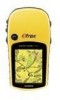
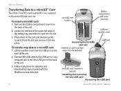
...inserted in card slot Installing and removing the microSD card Accessing the USB port eTrex HC series Owner's Manual Press down on the back of the unit. 2. To transfer map data to a microSD™ Card The eTrex Vista HCx and Legend HCx are equipped with cover removed PUSH TO EJECT USB... port weather cover Accessing the microSD card slot Contacts on the back of the battery tray, and slide the card into the slot. 3. Follow instructions for selecting and downloading maps provided with...
...inserted in card slot Installing and removing the microSD card Accessing the USB port eTrex HC series Owner's Manual Press down on the back of the unit. 2. To transfer map data to a microSD™ Card The eTrex Vista HCx and Legend HCx are equipped with cover removed PUSH TO EJECT USB... port weather cover Accessing the microSD card slot Contacts on the back of the battery tray, and slide the card into the slot. 3. Follow instructions for selecting and downloading maps provided with...

Owner's Manual
Page 16
...an alarm to sound when you are selecting a Find item to navigate to, or adding a Find item to an existing route. eTrex HC series Owner's Manual See page 20. • View Sun and Moon-view Sun and Moon tables for a more accurate location reference. Different buttons appear ...create a new waypoint referencing another location by entering bearing and distance from the Find item list and press Enter, detailed information about downloading detailed maps. Basic Operation Using the Find Item Information Page When you select an item from the referenced location. With an information ...
...an alarm to sound when you are selecting a Find item to navigate to, or adding a Find item to an existing route. eTrex HC series Owner's Manual See page 20. • View Sun and Moon-view Sun and Moon tables for a more accurate location reference. Different buttons appear ...create a new waypoint referencing another location by entering bearing and distance from the Find item list and press Enter, detailed information about downloading detailed maps. Basic Operation Using the Find Item Information Page When you select an item from the referenced location. With an information ...
Owner's Manual
Page 17
... A geocache location is a waypoint with each category containing items near another location on the map: 1. Select an icon on to http://my.garmin.com, and click "Go Geocaching." Press and hold FIND. 2. Select an item from another item: 1. Finding a Waypoint The Waypoints page ...to pan the arrow (pointer) to open a Find list of items near the item. eTrex HC series Owner's Manual 13 Select a category icon, and press ENTER to the map location you or downloaded from others. Select Waypoints and choose a waypoint. Press MENU, select Change Reference. Press MENU...
... A geocache location is a waypoint with each category containing items near another location on the map: 1. Select an icon on to http://my.garmin.com, and click "Go Geocaching." Press and hold FIND. 2. Select an item from another item: 1. Finding a Waypoint The Waypoints page ...to pan the arrow (pointer) to open a Find list of items near the item. eTrex HC series Owner's Manual 13 Select a category icon, and press ENTER to the map location you or downloaded from others. Select Waypoints and choose a waypoint. Press MENU, select Change Reference. Press MENU...
Owner's Manual
Page 18
... cities near your current location. 3. Use the ROCKER to highlight a geocache on the Find Menu to find any additional information about the downloaded cache location is shown. 14 eTrex HC series Owner's Manual Finding a City Select Cities from the list, and press ENTER. Finding an Interstate Exit Use the Exits icon on the list...
... cities near your current location. 3. Use the ROCKER to highlight a geocache on the Find Menu to find any additional information about the downloaded cache location is shown. 14 eTrex HC series Owner's Manual Finding a City Select Cities from the list, and press ENTER. Finding an Interstate Exit Use the Exits icon on the list...
Owner's Manual
Page 19
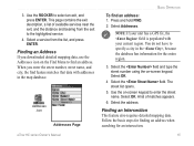
... distance and bearing from the list, and press ENTER. Select the address. Finding an Intersection This feature also requires detailed mapping data. eTrex HC series Owner's Manual 15 Select Addresses. NOTE: If your current region. Select the field and type the street number using the on -screen keypad to select... an address when searching for the entire region. 3. Press and hold FIND. 2. Use the ROCKER to enter the street name. When you downloaded detailed mapping data, use the Addresses icon on the Find Menu to specify a city in the map database. You do not have to find...
... distance and bearing from the list, and press ENTER. Select the address. Finding an Intersection This feature also requires detailed mapping data. eTrex HC series Owner's Manual 15 Select Addresses. NOTE: If your current region. Select the field and type the street number using the on -screen keypad to select... an address when searching for the entire region. 3. Press and hold FIND. 2. Use the ROCKER to enter the street name. When you downloaded detailed mapping data, use the Addresses icon on the Find Menu to specify a city in the map database. You do not have to find...
Owner's Manual
Page 20
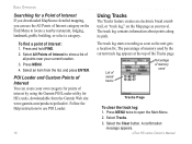
...use the All Points of interest: 1. List of saved tracks Percentage of memory used by using the Garmin POI Loader utility for a Point of Interest If you downloaded MapSource detailed mapping, you travel. Select All Points of Interest to open the Main Menu. 2. The...Interest category on the Map page as the unit gets a location fix. Press MENU. 4. Select the Clear button. eTrex HC series Owner's Manual Basic Operation Searching for HCx units, downloadable from the list, and press ENTER. Press and hold FIND. 2. A confirmation message appears. POI Loader and Custom ...
...use the All Points of interest: 1. List of saved tracks Percentage of memory used by using the Garmin POI Loader utility for a Point of Interest If you downloaded MapSource detailed mapping, you travel. Select All Points of Interest to open the Main Menu. 2. The...Interest category on the Map page as the unit gets a location fix. Press MENU. 4. Select the Clear button. eTrex HC series Owner's Manual Basic Operation Searching for HCx units, downloadable from the list, and press ENTER. Press and hold FIND. 2. A confirmation message appears. POI Loader and Custom ...
Owner's Manual
Page 45
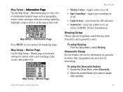
...On, Off, and Auto. • Symbol Set-select the symbol set to use (Auto, GARMIN, NOAA, International). To setup Routing: From the Setup Menu, select Routing. Geocache Setup See the Garmin web site for marine colors, spot soundings, light sectors, and symbol sets. Access the Setup... Menu, select Geocache. 2. Select the symbol fields if you want to view a list of downloaded detailed maps such as topographic, marine charts, and maps with auto-routing capability. eTrex HC series Owner's Manual...
...On, Off, and Auto. • Symbol Set-select the symbol set to use (Auto, GARMIN, NOAA, International). To setup Routing: From the Setup Menu, select Routing. Geocache Setup See the Garmin web site for marine colors, spot soundings, light sectors, and symbol sets. Access the Setup... Menu, select Geocache. 2. Select the symbol fields if you want to view a list of downloaded detailed maps such as topographic, marine charts, and maps with auto-routing capability. eTrex HC series Owner's Manual...
Quick Reference Guide
Page 1
...display all of the categories shown above, MapSource® detailed map data must be downloaded to the eTrex (Summit HC and Venture HC) or a microSD™ or TransFlash™ card (Vista HCx or Legend HCx...Map Page: 1. Press FIND. 2. Select Recent Finds, and press ENTER. 3. B © Copyright 2007 Garmin Ltd. OR To change any information on the Mark Waypoint page, select the appropriate field, and press ENTER to...ROCKER to move the pointer ( ) to the map item you want to the owner's manual for additional documentation and information. 190-00817-01 Rev. Select Go To, and press ENTER ...
...display all of the categories shown above, MapSource® detailed map data must be downloaded to the eTrex (Summit HC and Venture HC) or a microSD™ or TransFlash™ card (Vista HCx or Legend HCx...Map Page: 1. Press FIND. 2. Select Recent Finds, and press ENTER. 3. B © Copyright 2007 Garmin Ltd. OR To change any information on the Mark Waypoint page, select the appropriate field, and press ENTER to...ROCKER to move the pointer ( ) to the map item you want to the owner's manual for additional documentation and information. 190-00817-01 Rev. Select Go To, and press ENTER ...


