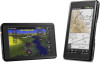
aera 660 Pilot s Guide
Page 6
...and terrain avoidance information. Garmin aera 660 Pilot's Guide 190-02017-20 Rev. WARNING: The altitude calculated by pressure altimeters. Databases used as a primary reference for use data link weather information for appropriate minimum clearance altitudes. The aera Terrain Proximity feature is NOT...and should not be updated regularly in , near, or around areas of the terrain data. WARNING: Navigation and terrain separation must be relied upon the use outdated database information. Warnings, Cautions & Notes WARNING: When installing the aera™, place the ...
...and terrain avoidance information. Garmin aera 660 Pilot's Guide 190-02017-20 Rev. WARNING: The altitude calculated by pressure altimeters. Databases used as a primary reference for use data link weather information for appropriate minimum clearance altitudes. The aera Terrain Proximity feature is NOT...and should not be updated regularly in , near, or around areas of the terrain data. WARNING: Navigation and terrain separation must be relied upon the use outdated database information. Warnings, Cautions & Notes WARNING: When installing the aera™, place the ...
aera 660 Pilot s Guide
Page 15
...Connecting to a Computer 125 Managing Files...126 MicroSD™ Card Use (Optional 127 Database Types...128 Database Purchase, Installation, and Updates 130 Appendix D: Installation and Interfacing 133 Mounting the aera in the Aircraft 133 Connecting to a Garmin VHF Comm Radio 137 Information about USB Drivers 139 Interfacing...139 Connecting to a GTX......148 Cleaning the Touchscreen 148 Protecting the Unit...148 Avoiding Theft...149 Appendix F: General TIS-A Information 151 TIS-A vs. A Garmin aera 660 Pilot's Guide iii TAS/TCAS...151 TIS-A Limitations...152 190-02017-20 Rev.
...Connecting to a Computer 125 Managing Files...126 MicroSD™ Card Use (Optional 127 Database Types...128 Database Purchase, Installation, and Updates 130 Appendix D: Installation and Interfacing 133 Mounting the aera in the Aircraft 133 Connecting to a Garmin VHF Comm Radio 137 Information about USB Drivers 139 Interfacing...139 Connecting to a GTX......148 Cleaning the Touchscreen 148 Protecting the Unit...148 Avoiding Theft...149 Appendix F: General TIS-A Information 151 TIS-A vs. A Garmin aera 660 Pilot's Guide iii TAS/TCAS...151 TIS-A Limitations...152 190-02017-20 Rev.
aera 660 Pilot s Guide
Page 85
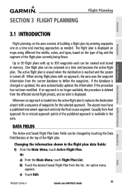
...a time and becomes the active flight plan. DATA FIELDS The Active and Saved Flight Plan Data Fields can be changed or updated, the aera automatically updates the information if the procedure has not been modified. Or: a) From the Main Menu, touch Flight Plan List. c) Touch.... A Garmin aera 660 Pilot's Guide 69 Appendices Index An option menu appears. If an approach is no longer available, the procedure is displayed on maps using different line widths, colors, and types, based on the aera consists of waypoints for the selected approach. If the database is displayed...
...a time and becomes the active flight plan. DATA FIELDS The Active and Saved Flight Plan Data Fields can be changed or updated, the aera automatically updates the information if the procedure has not been modified. Or: a) From the Main Menu, touch Flight Plan List. c) Touch.... A Garmin aera 660 Pilot's Guide 69 Appendices Index An option menu appears. If an approach is no longer available, the procedure is displayed on maps using different line widths, colors, and types, based on the aera consists of waypoints for the selected approach. If the database is displayed...
aera 660 Pilot s Guide
Page 103
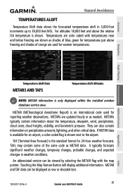
... METARs are shown as METAR data. They can be viewed by selecting the METAR flag with temperatures near and below freezing are updated hourly or as raw or decoded text. 190-02017-20 Rev. If METAR data is shown next to 39,000 feet MSL....the relative ISA temperature is only displayed within the installed aviation database service area. It typically forecasts significant weather changes, temporary changes, probable changes, and expected changes in 3,000-foot increments up to the airport. A Garmin aera 660 Pilot's Guide 87 Appendices Index Temperatures are used for 24-hour...
... METARs are shown as METAR data. They can be viewed by selecting the METAR flag with temperatures near and below freezing are updated hourly or as raw or decoded text. 190-02017-20 Rev. If METAR data is shown next to 39,000 feet MSL....the relative ISA temperature is only displayed within the installed aviation database service area. It typically forecasts significant weather changes, temporary changes, probable changes, and expected changes in 3,000-foot increments up to the airport. A Garmin aera 660 Pilot's Guide 87 Appendices Index Temperatures are used for 24-hour...
aera 660 Pilot s Guide
Page 130
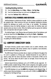
... pattern altitudes, noise abatement information, FBO phone numbers, hours of date, or not available. The database initialization shows the SafeTaxi database is updated on airports and heliports throughout the U.S. and it is current when the SafeTaxi name and expiration date... C for instructions on the aera, the database initialization indicates whether the databases are current, out of operation, local attractions, ground transportation, lodging, and services. If the AOPA database is displayed on the Waypoint Page. 114 Garmin aera 660 Pilot's Guide 190-02017-20...
... pattern altitudes, noise abatement information, FBO phone numbers, hours of date, or not available. The database initialization shows the SafeTaxi database is updated on airports and heliports throughout the U.S. and it is current when the SafeTaxi name and expiration date... C for instructions on the aera, the database initialization indicates whether the databases are current, out of operation, local attractions, ground transportation, lodging, and services. If the AOPA database is displayed on the Waypoint Page. 114 Garmin aera 660 Pilot's Guide 190-02017-20...
aera 660 Pilot s Guide
Page 144
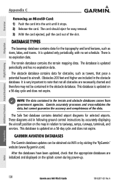
... or by accurately displaying the aircraft position on the splash screen during power-up. Appendices Index 128 Garmin aera 660 Pilot's Guide 190-02017-20 Rev. The database is updated only periodically, with no expiration date. The Safe Taxi database contains detailed airport diagrams for the topography and land features, such as towers, that pose a potential...
... or by accurately displaying the aircraft position on the splash screen during power-up. Appendices Index 128 Garmin aera 660 Pilot's Guide 190-02017-20 Rev. The database is updated only periodically, with no expiration date. The Safe Taxi database contains detailed airport diagrams for the topography and land features, such as towers, that pose a potential...
aera 660 Pilot s Guide
Page 145
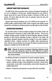
... listings of airports, VORs, NDBs, and more. However, once the databases are two navigation database products available: the Garmin Navigation database containing coverage for the world, available in behavior, nearest list functionality, airspace display, and map page display details due to data content variations. A Garmin aera 660 Pilot's Guide 129 Appendices Index 190-02017-20 Rev. Detailed...
... listings of airports, VORs, NDBs, and more. However, once the databases are two navigation database products available: the Garmin Navigation database containing coverage for the world, available in behavior, nearest list functionality, airspace display, and map page display details due to data content variations. A Garmin aera 660 Pilot's Guide 129 Appendices Index 190-02017-20 Rev. Detailed...

aera 660 Pilot s Guide
Page 146
... databases. 2) Connect to add. Appendices Index 130 Garmin aera 660 Pilot's Guide 190-02017-20 Rev. c) Touch the desired network to a WiFi network on a sectional chart. Additional Features Hazard Avoidance Flight Planning NOTE: After performing a navigation database update, verify all flight plan(s) (routes) are available online (www.fly.garmin.com). Purchasing/downloading/installing databases: 1) If necessary, from the aera 660...
... databases. 2) Connect to add. Appendices Index 130 Garmin aera 660 Pilot's Guide 190-02017-20 Rev. c) Touch the desired network to a WiFi network on a sectional chart. Additional Features Hazard Avoidance Flight Planning NOTE: After performing a navigation database update, verify all flight plan(s) (routes) are available online (www.fly.garmin.com). Purchasing/downloading/installing databases: 1) If necessary, from the aera 660...


