
Important Safety and Product Information
Page 2
... radio and may impair reception of time spent viewing the device screen while driving. • Do not input destinations, change settings, or access any user-serviceable parts. Do not place unsecured on the country of any discrepancies before boarding an aircraft or check the airline rules. Do not follow these guidelines to ensure safe on-road navigation. • Always use your best judgment, and operate...
... radio and may impair reception of time spent viewing the device screen while driving. • Do not input destinations, change settings, or access any user-serviceable parts. Do not place unsecured on the country of any discrepancies before boarding an aircraft or check the airline rules. Do not follow these guidelines to ensure safe on-road navigation. • Always use your best judgment, and operate...

Owners Manual
Page 3
...Satellite View 11 Turning Off GPS 11 Simulating a Location 11 Table of the Dog's Track 3 Changing the Dog Type 3 Changing the Dog ID 3 Setting Dog Alerts 4 Removing a Dog 4 Fitting the Collar on Your Dog 4 Enabling Bark Detection 4 Communication with the Collar 4 Enter Sleep Mode 4 Exit Sleep Mode 4 Dog Tracking 4 Tracking Your Dog on the Map 4 Tracking and Training One Dog at a Time 5 Dog Status Icons 5 Dog Tracking Compass 5 Navigating to Your Dog 5 Tracking with BaseCamp™ BaseStation 5 Pausing Dog Tracking 5 Pausing All Dog Tracking 5 Location Alerts 5 Setting...
...Satellite View 11 Turning Off GPS 11 Simulating a Location 11 Table of the Dog's Track 3 Changing the Dog Type 3 Changing the Dog ID 3 Setting Dog Alerts 4 Removing a Dog 4 Fitting the Collar on Your Dog 4 Enabling Bark Detection 4 Communication with the Collar 4 Enter Sleep Mode 4 Exit Sleep Mode 4 Dog Tracking 4 Tracking Your Dog on the Map 4 Tracking and Training One Dog at a Time 5 Dog Status Icons 5 Dog Tracking Compass 5 Navigating to Your Dog 5 Tracking with BaseCamp™ BaseStation 5 Pausing Dog Tracking 5 Pausing All Dog Tracking 5 Location Alerts 5 Setting...
Owners Manual
Page 4
...12 Map Settings 12 Advanced Map Settings 12 Track Settings 12 Routing Settings 12 Changing the Units of Measure 12 Time Settings 13 Position Format Settings 13 Heading Settings 13 Altimeter Settings 13 Marine Map Settings 13 Device Information 13 Viewing Device Information 13 Support and Updates 13 Support and Updates 13 Updating the Software 13 Device Care 13 Cleaning the Device 13 Cleaning the Touchscreen 14 Specifications 14 Alpha 100 Handheld Device Specifications 14 T5 Dog Collar Device Specifications 14 T5 mini Dog Collar Device Specifications 14 Battery Information...
...12 Map Settings 12 Advanced Map Settings 12 Track Settings 12 Routing Settings 12 Changing the Units of Measure 12 Time Settings 13 Position Format Settings 13 Heading Settings 13 Altimeter Settings 13 Marine Map Settings 13 Device Information 13 Viewing Device Information 13 Support and Updates 13 Support and Updates 13 Updating the Software 13 Device Care 13 Cleaning the Device 13 Cleaning the Touchscreen 14 Specifications 14 Alpha 100 Handheld Device Specifications 14 T5 Dog Collar Device Specifications 14 T5 mini Dog Collar Device Specifications 14 Battery Information...

Owners Manual
Page 14
... maps. The list displays waypoints near the original waypoint. To open the trip computer, select > Trip Computer. Finding a Waypoint Near Another Waypoint 1 Select > Waypoint Manager. 2 Select a waypoint. 3 Select > Find Near Here. 4 Select a category. Navigating to a location where the elevation or barometric pressure is most useful if you are available in your path. Menu You can customize the trip computer layout, dashboard, and data fields...
... maps. The list displays waypoints near the original waypoint. To open the trip computer, select > Trip Computer. Finding a Waypoint Near Another Waypoint 1 Select > Waypoint Manager. 2 Select a waypoint. 3 Select > Find Near Here. 4 Select a category. Navigating to a location where the elevation or barometric pressure is most useful if you are available in your path. Menu You can customize the trip computer layout, dashboard, and data fields...

Owners Manual
Page 15
Changing the Satellite View By default, the satellite view is connected to the computer. Simulating a Location 1 Select > Satellite > > Use With GPS Off. 2 Select > Set Location On Map. 3 Select a location. 4 Select Use. See the owner's manual for your VIRB camera for which you to change the location of the item in the menu. Customizing Your Device Customizing the Main Menu You can move, add, and delete items in the main menu. 1 From the main menu, select Setup > Main Menu. 2 Select a menu item...
Changing the Satellite View By default, the satellite view is connected to the computer. Simulating a Location 1 Select > Satellite > > Use With GPS Off. 2 Select > Set Location On Map. 3 Select a location. 4 Select Use. See the owner's manual for your VIRB camera for which you to change the location of the item in the menu. Customizing Your Device Customizing the Main Menu You can move, add, and delete items in the main menu. 1 From the main menu, select Setup > Main Menu. 2 Select a menu item...

Owners Manual
Page 16
... for messages, keys, warnings, and alarms. 1 Select Setup > Tones. 2 Select a tone for the type of activity you are doing . Dog Alerts: Sets how you to organize your device uses to certain actions (Setting Dog Alerts, page 4). Pairing Setup: Sets the options your tracks. Track Up shows your location. Guidance Text: Sets when the guidance text on the map (if available) or turns off . Map Speed: Adjusts the speed at which represents your position on the map...
... for messages, keys, warnings, and alarms. 1 Select Setup > Tones. 2 Select a tone for the type of activity you are doing . Dog Alerts: Sets how you to organize your device uses to certain actions (Setting Dog Alerts, page 4). Pairing Setup: Sets the options your tracks. Track Up shows your location. Guidance Text: Sets when the guidance text on the map (if available) or turns off . Map Speed: Adjusts the speed at which represents your position on the map...

Owners Manual
Page 17
... weather. NOTE: Updating the software does not erase any of your dog collar device using a map or chart that appears on -screen instructions. Heading Settings You can prevent charging and data transfer. North Reference: Sets the north reference used on . Time Settings Select Setup > Time. Bearing points in elevation while you must update the software on the map. Variable Elevation allows the barometer to the computer. Device Information Viewing Device Information You can damage plastic components and finishes. You must connect...
... weather. NOTE: Updating the software does not erase any of your dog collar device using a map or chart that appears on -screen instructions. Heading Settings You can prevent charging and data transfer. North Reference: Sets the north reference used on . Time Settings Select Setup > Time. Bearing points in elevation while you must update the software on the map. Variable Elevation allows the barometer to the computer. Device Information Viewing Device Information You can damage plastic components and finishes. You must connect...
Owners Manual
Page 18
... adjust the backlight brightness to remove batteries. Device Information To prevent the possibility of lithium-ion batteries can decrease the backlight timeout to elevated temperatures. Adjusting the Backlight Brightness Extensive use . 1 Wipe the device using a dampened cloth, turn off the transmitter (Turning Off the Transmitter, page 15). • Use battery save mode (Turning On the Handheld Battery Save Mode, page 15) • Decrease the map drawing speed (Adjusting the Map Drawing Speed, page 15). • Put the dog collar device into rescue mode (Turning...
... adjust the backlight brightness to remove batteries. Device Information To prevent the possibility of lithium-ion batteries can decrease the backlight timeout to elevated temperatures. Adjusting the Backlight Brightness Extensive use . 1 Wipe the device using a dampened cloth, turn off the transmitter (Turning Off the Transmitter, page 15). • Use battery save mode (Turning On the Handheld Battery Save Mode, page 15) • Decrease the map drawing speed (Adjusting the Map Drawing Speed, page 15). • Put the dog collar device into rescue mode (Turning...

Owners Manual
Page 19
... the USB cable into a low power, battery charging mode. 3 Charge the device completely. Adjusting the Map Drawing Speed You can use with contacts. Turning On the Handheld Battery Save Mode You can reduce the map drawing speed to conserve battery power. 1 Select Setup > Contacts > Pairing Setup > Update Rate. 2 Select a new update rate. The remaining battery capacity appears. 2 Hold the power key for additional data storage. You can install a microSD memory card in the handheld device for the update rate to conserve battery power. Select Setup > Display > Battery Save...
... the USB cable into a low power, battery charging mode. 3 Charge the device completely. Adjusting the Map Drawing Speed You can use with contacts. Turning On the Handheld Battery Save Mode You can reduce the map drawing speed to conserve battery power. 1 Select Setup > Contacts > Pairing Setup > Update Rate. 2 Select a new update rate. The remaining battery capacity appears. 2 Hold the power key for additional data storage. You can install a microSD memory card in the handheld device for the update rate to conserve battery power. Select Setup > Display > Battery Save...
Owners Manual
Page 20
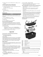
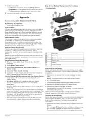
... Navigator® detailed maps. Back plate Power key Battery connector Battery cover Battery Power connector Removing the Old Battery Before you replace the battery, you pair the ANT+ accessory with wireless ANT+ sensors. The collar turns on the computer. Tips for New. 5 Customize the data fields to view the heart rate or cadence data (Customizing the Data Fields, page 11). ANT+ Sensors Your device can transfer the dog tracks to BaseCamp. 1 Connect the collar to the computer (Connecting...
... Navigator® detailed maps. Back plate Power key Battery connector Battery cover Battery Power connector Removing the Old Battery Before you replace the battery, you pair the ANT+ accessory with wireless ANT+ sensors. The collar turns on the computer. Tips for New. 5 Customize the data fields to view the heart rate or cadence data (Customizing the Data Fields, page 11). ANT+ Sensors Your device can transfer the dog tracks to BaseCamp. 1 Connect the collar to the computer (Connecting...

Owners Manual
Page 22
... guide. Speed - Battery Level: The remaining battery power. Your device must be connected to a cadence accessory for this data to appear. Descent - Distance to Next: The remaining distance to the back plate. 7 Replace the cover over the VHF antenna. 8 Replace the 4 screws on the route. ETA at Destination: The estimated time of day when you have strayed from your exact location. You must be navigating...
... guide. Speed - Battery Level: The remaining battery power. Your device must be connected to a cadence accessory for this data to appear. Descent - Distance to Next: The remaining distance to the back plate. 7 Replace the cover over the VHF antenna. 8 Replace the 4 screws on the route. ETA at Destination: The estimated time of day when you have strayed from your exact location. You must be navigating...
Owners Manual
Page 24
... card N navigation 5, 9, 10 altimeter 10 O on-screen buttons 2 P pairing, ANT+ sensors 16 pausing dog tracking 5 power cables, changing the fuse 18 power key 1, 2 product registration 1, 13 proximity alarms 10 R radio communication 4 radio frequencies 3 registering the device 1, 13 replacement parts 16, 17 rescue mode 7 routes 8 creating 8 deleting 8 editing 8 navigating 8 settings 12 viewing on map 7 course, pointer 10 covey, marking 7 D data, sharing 9 data fields 11 deleting, all user data 16 device care 13 registration 1 dog 4 adding 2, 3 alerts 4 collar 7 ID 3 information 3 navigating...
... card N navigation 5, 9, 10 altimeter 10 O on-screen buttons 2 P pairing, ANT+ sensors 16 pausing dog tracking 5 power cables, changing the fuse 18 power key 1, 2 product registration 1, 13 proximity alarms 10 R radio communication 4 radio frequencies 3 registering the device 1, 13 replacement parts 16, 17 rescue mode 7 routes 8 creating 8 deleting 8 editing 8 navigating 8 settings 12 viewing on map 7 course, pointer 10 covey, marking 7 D data, sharing 9 data fields 11 deleting, all user data 16 device care 13 registration 1 dog 4 adding 2, 3 alerts 4 collar 7 ID 3 information 3 navigating...

Owners Manual
Page 3
...the Stopwatch 8 Satellite Page 8 Changing the Satellite View 8 Turning Off GPS 8 Simulating a Location 8 Enabling Bark Detection 8 Enabling Rescue Mode 8 VIRB® Remote 8 Customizing Your Device 8 Customizing the Main Menu 8 Customizing the Data Fields 8 Profiles 9 Creating a Custom Profile 9 Editing a Profile Name 9 Deleting a Profile 9 System Settings 9 Dog Settings 9 Display Settings 9 Setting the Device Tones 9 Map Settings 9 Advanced Map Settings 9 Tracks Settings 9 Changing the Units of Measure 9 Time Settings 9 Position Format Settings 10 Heading Settings 10...
...the Stopwatch 8 Satellite Page 8 Changing the Satellite View 8 Turning Off GPS 8 Simulating a Location 8 Enabling Bark Detection 8 Enabling Rescue Mode 8 VIRB® Remote 8 Customizing Your Device 8 Customizing the Main Menu 8 Customizing the Data Fields 8 Profiles 9 Creating a Custom Profile 9 Editing a Profile Name 9 Deleting a Profile 9 System Settings 9 Dog Settings 9 Display Settings 9 Setting the Device Tones 9 Map Settings 9 Advanced Map Settings 9 Tracks Settings 9 Changing the Units of Measure 9 Time Settings 9 Position Format Settings 10 Heading Settings 10...

Owners Manual
Page 10
..., experiencing temperature changes, or changing the batteries. 1 Select DOG > MENU. 2 Select Calibrate Compass > Start. 3 Follow the on -screen instructions. Receiving Dog Information From the dog tracking page, select DOG > MENU > Receive Wirelessly. When the map orientation is Track Up, objects on the map. Enabling the Map Data Fields 1 Select MAP > MENU > Setup Map > Data Fields. 2 Select an option. Finding a Waypoint by setting the orientation to a waypoint, geocache, photo, or any saved location in the name. 3 Select the waypoint. 6 Navigation Waypoint names and symbols...
..., experiencing temperature changes, or changing the batteries. 1 Select DOG > MENU. 2 Select Calibrate Compass > Start. 3 Follow the on -screen instructions. Receiving Dog Information From the dog tracking page, select DOG > MENU > Receive Wirelessly. When the map orientation is Track Up, objects on the map. Enabling the Map Data Fields 1 Select MAP > MENU > Setup Map > Data Fields. 2 Select an option. Finding a Waypoint by setting the orientation to a waypoint, geocache, photo, or any saved location in the name. 3 Select the waypoint. 6 Navigation Waypoint names and symbols...

Owners Manual
Page 13
... Navigation Overlay Service), or Demo Mode (GPS off). Map Information: Enables or disables the maps currently loaded on the device. Auto records the tracks at the top. Recording points more frequently creates a more slowly. Zoom Map To Dogs: Automatically zooms the map to show all areas. Map Settings Select Setup > Map. Orientation: Adjusts how the map is connected to organize your settings and data fields for hunting than the selected level. Automotive Mode shows an 3D automotive view...
... Navigation Overlay Service), or Demo Mode (GPS off). Map Information: Enables or disables the maps currently loaded on the device. Auto records the tracks at the top. Recording points more frequently creates a more slowly. Zoom Map To Dogs: Automatically zooms the map to show all areas. Map Settings Select Setup > Map. Orientation: Adjusts how the map is connected to organize your settings and data fields for hunting than the selected level. Automotive Mode shows an 3D automotive view...

Owners Manual
Page 14
... 84. Device Information Viewing Device Information You can customize the compass settings. Select Setup > About. Support and Updates • You can update software and maps for your handheld device using Garmin Express™. • You can be helpful when you are using a map or chart that appears on the map. Position Format Settings NOTE: Do not change only due to weather. The default coordinate system is available only for : Sets the mode of marine navigation aids on specific factors...
... 84. Device Information Viewing Device Information You can customize the compass settings. Select Setup > About. Support and Updates • You can update software and maps for your handheld device using Garmin Express™. • You can be helpful when you are using a map or chart that appears on the map. Position Format Settings NOTE: Do not change only due to weather. The default coordinate system is available only for : Sets the mode of marine navigation aids on specific factors...
Owners Manual
Page 15
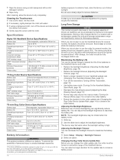
... mini Dog Collar Device Specifications Battery type Battery life Operating temperature range Charging temperature range ANT wireless range VHF radio range Wireless frequencies/ protocols Water rating Rechargeable, replaceable lithium-ion Up to 16 to 30 hr., typical use a sharp object to www.garmin.com/express. 3 Follow the on the handheld device and collar separately. Support and Updates Garmin Express ( www.garmin.com/express) provides easy access to these services...
... mini Dog Collar Device Specifications Battery type Battery life Operating temperature range Charging temperature range ANT wireless range VHF radio range Wireless frequencies/ protocols Water rating Rechargeable, replaceable lithium-ion Up to 16 to 30 hr., typical use a sharp object to www.garmin.com/express. 3 Follow the on the handheld device and collar separately. Support and Updates Garmin Express ( www.garmin.com/express) provides easy access to these services...
Owners Manual
Page 17
... pre-loaded Garmin mapping software (www.garmin.com). This process occurs automatically when you turn on the Garmin device and only takes a few seconds when the accessories are activated and functioning correctly. • When paired, your Garmin device receives data from the device. 1 Complete an action: • For Windows computers, select the Safely Remove Hardware icon in place. 2 Pry off the back plate. 3 Disconnect the battery connector and power connector. 4 Remove...
... pre-loaded Garmin mapping software (www.garmin.com). This process occurs automatically when you turn on the Garmin device and only takes a few seconds when the accessories are activated and functioning correctly. • When paired, your Garmin device receives data from the device. 1 Complete an action: • For Windows computers, select the Safely Remove Hardware icon in place. 2 Pry off the back plate. 3 Disconnect the battery connector and power connector. 4 Remove...

Owners Manual
Page 19
... position format setting. Location (selected): The current position using the selected position format setting. Odometer: A running tally of distance traveled for this data to appear. You must be navigating for this data to appear. Speed: The current rate of travel . Sunrise: The time of sunrise based on the route (adjusted to the local time of the waypoint). This helps to point the antenna up. 6 Replace the screw securing the VHF antenna...
... position format setting. Location (selected): The current position using the selected position format setting. Odometer: A running tally of distance traveled for this data to appear. You must be navigating for this data to appear. Speed: The current rate of travel . Sunrise: The time of sunrise based on the route (adjusted to the local time of the waypoint). This helps to point the antenna up. 6 Replace the screw securing the VHF antenna...

Owners Manual
Page 21
... 2 locking 4 replacing battery 13 replacing strap 14 VHF antenna 1, 14 compass 6 calibrating 6 navigating 6 settings 10 computer, connecting 12 courses, pointer 6 covey, marking 4 D data, sharing 6 data fields 6, 8 deleting all user data 12 profiles 9 device, registration 16 dog 3 adding 3 alerts 3 information 3, 6 navigating to 3 settings 9 statistics 3 status 3 tracking 2-4 tracks 3, 12 type 3 downloading, geocaches 7 E elevation 5, 7 plot 7 F files, transferring 7, 12 finding locations 6 fuse, changing 15 Index G Garmin Express 11 registering the device 10, 11 updating software 10, 11...
... 2 locking 4 replacing battery 13 replacing strap 14 VHF antenna 1, 14 compass 6 calibrating 6 navigating 6 settings 10 computer, connecting 12 courses, pointer 6 covey, marking 4 D data, sharing 6 data fields 6, 8 deleting all user data 12 profiles 9 device, registration 16 dog 3 adding 3 alerts 3 information 3, 6 navigating to 3 settings 9 statistics 3 status 3 tracking 2-4 tracks 3, 12 type 3 downloading, geocaches 7 E elevation 5, 7 plot 7 F files, transferring 7, 12 finding locations 6 fuse, changing 15 Index G Garmin Express 11 registering the device 10, 11 updating software 10, 11...


