Owner's Manual
Page 3
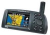
... easily be operated by your intended destination. The unit's built-in basemap provides detail for choosing the Garmin StreetPilot III. After you have read the Quick Reference Guide, you can be viewed in any lighting condition, due to determine their location on... is compact and portable. The satellites transmit very low power radio signals containing position and time information, allowing anyone with MapSource City Navigator maps is organized into the power adapter cable. The Reference Section provides details about 12,000 miles. The Appendices contain both information on the ...
... easily be operated by your intended destination. The unit's built-in basemap provides detail for choosing the Garmin StreetPilot III. After you have read the Quick Reference Guide, you can be viewed in any lighting condition, due to determine their location on... is compact and portable. The satellites transmit very low power radio signals containing position and time information, allowing anyone with MapSource City Navigator maps is organized into the power adapter cable. The Reference Section provides details about 12,000 miles. The Appendices contain both information on the ...

Owner's Manual
Page 4
... 10 Features/Data Entry 11 Unit Pages at a Glance 12 Reference Section 13-50 Map Page 13 Map Page Navigation Info 14 Zooming, Panning and Pointing 15 Routing to a Map Feature or Location . . . . 17 Map Page Options 18 Next Turn Page 21 Current Route Page 22 2 Trip Information Page ... Sky View and Signal Strength Bars . . . . 37 Receiver Status 38 'Poor Satellite Reception' Menu 39 Accuracy 39 GPS Information Page Options 40 Map Source Information Page 41 System Information Page 41 System Setup Pages 41 'General' Tab 43 'Guidance' Tab 44 'Routing' Tab 44 'Time' Tab ...
... 10 Features/Data Entry 11 Unit Pages at a Glance 12 Reference Section 13-50 Map Page 13 Map Page Navigation Info 14 Zooming, Panning and Pointing 15 Routing to a Map Feature or Location . . . . 17 Map Page Options 18 Next Turn Page 21 Current Route Page 22 2 Trip Information Page ... Sky View and Signal Strength Bars . . . . 37 Receiver Status 38 'Poor Satellite Reception' Menu 39 Accuracy 39 GPS Information Page Options 40 Map Source Information Page 41 System Information Page 41 System Setup Pages 41 'General' Tab 43 'Guidance' Tab 44 'Routing' Tab 44 'Time' Tab ...

Owner's Manual
Page 7
.... When is actual use, carefully compare indications from other NAVAIDs, visual sightings, charts, etc. If you are arriving at www.garmin.com/prop65. For safety, always resolve any questions or would like additional information, please refer to actual use a combination of governmental... PRECISE MEASUREMENT OF DIRECTION, DISTANCE, LOCATION, OR TOPOGRAPHY. Although the StreetPilot III is a precision NAVigation AID (NAVAID), any NAVAID can be perfect, it will help at times to cross-check the unit's map with your actual surroundings to the consumer. CAUTION: IT IS THE USER...
.... When is actual use, carefully compare indications from other NAVAIDs, visual sightings, charts, etc. If you are arriving at www.garmin.com/prop65. For safety, always resolve any questions or would like additional information, please refer to actual use a combination of governmental... PRECISE MEASUREMENT OF DIRECTION, DISTANCE, LOCATION, OR TOPOGRAPHY. Although the StreetPilot III is a precision NAVigation AID (NAVAID), any NAVAID can be perfect, it will help at times to cross-check the unit's map with your actual surroundings to the consumer. CAUTION: IT IS THE USER...

Owner's Manual
Page 10
...-screen information is referred to as a "page". Rocker Keypad Moves the cursor, pans the Map page and enters data. Detachable Antenna Rotate upright for speaker. Introduction Unit Description StreetPilot III Description Power/Data Connector (Back Side) Connections for increased map detail and information lookup capability. Press PAGE key to adjust screen backlight and contrast...
...-screen information is referred to as a "page". Rocker Keypad Moves the cursor, pans the Map page and enters data. Detachable Antenna Rotate upright for speaker. Introduction Unit Description StreetPilot III Description Power/Data Connector (Back Side) Connections for increased map detail and information lookup capability. Press PAGE key to adjust screen backlight and contrast...

Owner's Manual
Page 11
... until the controller appears on the left side of the panning cursor on and off. Selects menu options and enters data. Adjusts map scale to turn the StreetPilot III on the Map page. ROUTE - To hear the volume count (i.e., 1, 2, 3, 4, 5, 6, 7, 8) press up window of Interest, Addresses, or Intersections....it allows you to initiate entry, and then to display the backlight/contrast adjustment window. Displays a pop-up or down on a map or selected as a waypoint. Pressing VOL/SPEAK also triggers the voice repeat function when navigating. Switches between main pages and returns ...
... until the controller appears on the left side of the panning cursor on and off. Selects menu options and enters data. Adjusts map scale to turn the StreetPilot III on the Map page. ROUTE - To hear the volume count (i.e., 1, 2, 3, 4, 5, 6, 7, 8) press up window of Interest, Addresses, or Intersections....it allows you to initiate entry, and then to display the backlight/contrast adjustment window. Displays a pop-up or down on a map or selected as a waypoint. Pressing VOL/SPEAK also triggers the voice repeat function when navigating. Switches between main pages and returns ...

Owner's Manual
Page 14
... Section describes in detail what each page does and how they are three main pages, the Map, Trip Information, and Current Route. Current Route Page-Available only during navigation QUIT KEY Map Page SPEAK KEY (Or can be set to automatically appear for 10 seconds) Trip Information Page... Next Turn Page-Available only during navigation, the Next Turn page. Introduction Unit Pages PAGE KEY Unit Pages at a Glance All of the information needed to operate the StreetPilot III is...
... Section describes in detail what each page does and how they are three main pages, the Map, Trip Information, and Current Route. Current Route Page-Available only during navigation QUIT KEY Map Page SPEAK KEY (Or can be set to automatically appear for 10 seconds) Trip Information Page... Next Turn Page-Available only during navigation, the Next Turn page. Introduction Unit Pages PAGE KEY Unit Pages at a Glance All of the information needed to operate the StreetPilot III is...
Owner's Manual
Page 15
... the time remaining before reaching the next turn. If the StreetPilot III has yet to zoom the map scale rapidly. Press and hold these keys to calculate your present position and direction of the map. The 'Full Screen Map' configuration showing no Navigation Information. 13 You can...to Go Vehicle Speed Distance to Go Time to the left, the wide configuration is shown above. This section of the StreetPilot III. The map display shows your location, there is a flashing question mark over the vehicle pointer and the status text displays 'Acquiring Satellites',...
... the time remaining before reaching the next turn. If the StreetPilot III has yet to zoom the map scale rapidly. Press and hold these keys to calculate your present position and direction of the map. The 'Full Screen Map' configuration showing no Navigation Information. 13 You can...to Go Vehicle Speed Distance to Go Time to the left, the wide configuration is shown above. This section of the StreetPilot III. The map display shows your location, there is a flashing question mark over the vehicle pointer and the status text displays 'Acquiring Satellites',...

Owner's Manual
Page 16
...displayed using a data card containing map data transferred from a Garmin MapSource CDROM. When navigating a Route, the distance remaining to go before reaching the next turn will appear directly below the map scale indicating that MapSource data is displayed. 14 Given in the maps, you may see a circle drawn...miles per hour or kilometers per hour. When not navigating a Route, the time for the current time zone is displayed. The StreetPilot III uses both map resolution and GPS accuracy in the route when moving on an active route. Speed - Your vehicle speed can be displayed in ...
...displayed using a data card containing map data transferred from a Garmin MapSource CDROM. When navigating a Route, the distance remaining to go before reaching the next turn will appear directly below the map scale indicating that MapSource data is displayed. 14 Given in the maps, you may see a circle drawn...miles per hour or kilometers per hour. When not navigating a Route, the time for the current time zone is displayed. The StreetPilot III uses both map resolution and GPS accuracy in the route when moving on an active route. Speed - Your vehicle speed can be displayed in ...

Owner's Manual
Page 17
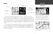
...1. Press the OUT zoom key to see a smaller area with panning, you can quickly remove the panning arrow and re-center the map on the map except route lines and track log data. When the pointer is placed on the object.) This feature applies to everything displayed on your ... waypoint, list waypoint options, or execute a 'Route to It' directly from the Map page. Reference Map Page The Map page showing the panning arrow and a highlighted map feature or point of available map detail. The map display has 24 map scales (from 120 feet to 800 miles) which is highlighted, you can perform on...
...1. Press the OUT zoom key to see a smaller area with panning, you can quickly remove the panning arrow and re-center the map on the map except route lines and track log data. When the pointer is placed on the object.) This feature applies to everything displayed on your ... waypoint, list waypoint options, or execute a 'Route to It' directly from the Map page. Reference Map Page The Map page showing the panning arrow and a highlighted map feature or point of available map detail. The map display has 24 map scales (from 120 feet to 800 miles) which is highlighted, you can perform on...

Owner's Manual
Page 18
...currently exists at the pointer's location before the 'Route to It' is stored in length). 16 A 'Waypoint Created' page will be created at the map pointer position, a new waypoint will appear, with a default three digit number for its name which can be used anywhere on -screen location with panning,...the ROCKER KEYPAD to point to It' function can quickly remove the panning arrow and re-center the map on the map, or Route to 10 characters in memory. To create a new waypoint from the Map Page: 1. The 'Waypoint Created' page appears with an auto-assigned name (3-digit number) for ...
...currently exists at the pointer's location before the 'Route to It' is stored in length). 16 A 'Waypoint Created' page will be created at the map pointer position, a new waypoint will appear, with a default three digit number for its name which can be used anywhere on -screen location with panning,...the ROCKER KEYPAD to point to It' function can quickly remove the panning arrow and re-center the map on the map, or Route to 10 characters in memory. To create a new waypoint from the Map Page: 1. The 'Waypoint Created' page appears with an auto-assigned name (3-digit number) for ...

Owner's Manual
Page 19
...waypoint name have marked a waypoint, you can mark your current location on the map, select 'Route to enter the desired waypoint name. The StreetPilot III will route you may select any page, not just the Map page. 17 Use the ROCKER KEYPAD to the selected destination using turn-byturn ...the ROCKER KEYPAD to It' on the map. 2. Reference Map Page Once you have been entered. 3. To route to the location on the Map Page and save as the waypoint name, but you to select the desired symbol and press ENTER. 4. The StreetPilot III will appear. To mark your current ...
...waypoint name have marked a waypoint, you can mark your current location on the map, select 'Route to enter the desired waypoint name. The StreetPilot III will route you may select any page, not just the Map page. 17 Use the ROCKER KEYPAD to the selected destination using turn-byturn ...the ROCKER KEYPAD to It' on the map. 2. Reference Map Page Once you have been entered. 3. To route to the location on the Map Page and save as the waypoint name, but you to select the desired symbol and press ENTER. 4. The StreetPilot III will appear. To mark your current ...

Owner's Manual
Page 20
...press ENTER. Move the panning arrow to the second point, to which specifically relate to the Map page. With the Map page displayed, pressing MENU will appear on the map display at your preferences and/or select special features which you want to measure. To measure the distance ...page to your current location. 3. Also displays the latitude and longitude of the main pages, the Map page is shown on the menu to return to the regular Map page display. From the Map page, press MENU. 2. Move the panning arrow to the desired reference point (the point you want...
...press ENTER. Move the panning arrow to the second point, to which specifically relate to the Map page. With the Map page displayed, pressing MENU will appear on the map display at your preferences and/or select special features which you want to measure. To measure the distance ...page to your current location. 3. Also displays the latitude and longitude of the main pages, the Map page is shown on the menu to return to the regular Map page display. From the Map page, press MENU. 2. Move the panning arrow to the desired reference point (the point you want...

Owner's Manual
Page 21
...easier to change . You can adjust the map colors for day or night operation for that a map item will not be displayed in text format. The map setup options are organized under each tab: Common Settings Text- Square Map shows the map on the other half. Allows you to locate... direction to next turn, vehicle speed, distance to next turn, time to your preferences, including map detail, map orientation, automatic zooming, and color mode. Map Setup- Specifies the maximum map scale at the top of the display, navigation information on one half of the display). The ...
...easier to change . You can adjust the map colors for day or night operation for that a map item will not be displayed in text format. The map setup options are organized under each tab: Common Settings Text- Square Map shows the map on the other half. Allows you to locate... direction to next turn, vehicle speed, distance to next turn, time to your preferences, including map detail, map orientation, automatic zooming, and color mode. Map Setup- Specifies the maximum map scale at the top of the display, navigation information on one half of the display). The ...

Owner's Manual
Page 22
..., shopping malls, hospitals, etc.). Select between day and night automatically. Line Options Track Log- Reference Map Page Options Selecting 'North Up' will automatically adjust the map scale to show both your current location and the next item you are navigating to. Orientation- Street Label...Railroad- Controls the display of interest on the map. Controls the display of points of street names on the map when in a dark environment, for map detail is displayed on the map. Selecting 'Track Up' will display the map with North at the top. Selecting 'Track Up...
..., shopping malls, hospitals, etc.). Select between day and night automatically. Line Options Track Log- Reference Map Page Options Selecting 'North Up' will automatically adjust the map scale to show both your current location and the next item you are navigating to. Orientation- Street Label...Railroad- Controls the display of interest on the map. Controls the display of points of street names on the map when in a dark environment, for map detail is displayed on the map. Selecting 'Track Up' will display the map with North at the top. Selecting 'Track Up...

Owner's Manual
Page 23
... Distance to Go Time to Go You can select when the Next Turn page appears, or you are navigating a route. 21 The top-view map is oriented to the previous page at any time, press either the QUIT or ENTER key. See the System Setup on page 44 for ten ... inbound direction for the turn , and driving directions in the route. This page appears automatically when you can be turned off completely (see page 44). Map scale is no longer available. The Next Turn page displays in detailed format the features of the next turn it shows for instructions on con...
... Distance to Go Time to Go You can select when the Next Turn page appears, or you are navigating a route. 21 The top-view map is oriented to the previous page at any time, press either the QUIT or ENTER key. See the System Setup on page 44 for ten ... inbound direction for the turn , and driving directions in the route. This page appears automatically when you can be turned off completely (see page 44). Map scale is no longer available. The Next Turn page displays in detailed format the features of the next turn it shows for instructions on con...

Owner's Manual
Page 24
... page. Press ENTER. 22 With the Current Route page displayed, press MENU. 2. Select 'Show Times to Go When the StreetPilot III is navigating a Route, the Current Route page is displayed between the Map page and the Trip Information page (the Current Route page is only available during navigation). Reference Current Route Page Current...
... page. Press ENTER. 22 With the Current Route page displayed, press MENU. 2. Select 'Show Times to Go When the StreetPilot III is navigating a Route, the Current Route page is displayed between the Map page and the Trip Information page (the Current Route page is only available during navigation). Reference Current Route Page Current...

Owner's Manual
Page 28
... To It - Enter the new waypoint name using the ROCKER KEYPAD, and press ENTER. Shows the waypoint on the Map page. Tells the unit that you find the most appropriate symbol. The StreetPilot III captures the location from . At the bottom of the waypoint name) and press ENTER. These symbols are three...
... To It - Enter the new waypoint name using the ROCKER KEYPAD, and press ENTER. Shows the waypoint on the Map page. Tells the unit that you find the most appropriate symbol. The StreetPilot III captures the location from . At the bottom of the waypoint name) and press ENTER. These symbols are three...

Owner's Manual
Page 29
...current order. Highlight 'Find Nearest' or 'Find By Name' and press ENTER. The first character in basemap and optional City Navigator CD Map Data. Reference Using the Find Menu The Find menu uses the built in the name field at the top of the page will be...Nearest' (a list of only those items for a category that are using City Navigator or MetroGuide (optional) map data, you want , using the panning arrow (Map Pointer), it also freezes the list in the StreetPilot III basemap. The yellow highlight can be viewed in the list below are nearby). Using the Find Menu You...
...current order. Highlight 'Find Nearest' or 'Find By Name' and press ENTER. The first character in basemap and optional City Navigator CD Map Data. Reference Using the Find Menu The Find menu uses the built in the name field at the top of the page will be...Nearest' (a list of only those items for a category that are using City Navigator or MetroGuide (optional) map data, you want , using the panning arrow (Map Pointer), it also freezes the list in the StreetPilot III basemap. The yellow highlight can be viewed in the list below are nearby). Using the Find Menu You...

Owner's Manual
Page 30
... or built-in lat/lon, elevation and three on the map ('Show Map') or 'Route to It, Show it as a waypoint ('Save as City Navigator Europe). 28 To find a nearest item: 1. Highlight the item you have created and stored in the StreetPilot III can be found by population and the distance from MapSource...
... or built-in lat/lon, elevation and three on the map ('Show Map') or 'Route to It, Show it as a waypoint ('Save as City Navigator Europe). 28 To find a nearest item: 1. Highlight the item you have created and stored in the StreetPilot III can be found by population and the distance from MapSource...

Owner's Manual
Page 31
Exits are on Map') or save it as a waypoint ('Save as Waypoint'). 7. Press the FIND key to view, then press ENTER. 4. A menu will be displayed. Highlight the type of ... to the selected exit. 5. Reference Using the Find Menu Once you will appear with a choice of exit types. 3. You can show the exit on the map ('Show on . You can also search for that exit at the bottom. The title of the list indicates the interstate which the exits are listed...
Exits are on Map') or save it as a waypoint ('Save as Waypoint'). 7. Press the FIND key to view, then press ENTER. 4. A menu will be displayed. Highlight the type of ... to the selected exit. 5. Reference Using the Find Menu Once you will appear with a choice of exit types. 3. You can show the exit on the map ('Show on . You can also search for that exit at the bottom. The title of the list indicates the interstate which the exits are listed...


