Owners Manual
Page 3
... manual. Be sure to an authorized Garmin dealer for fun. iii If you how to understand the features on the StreetPilot's GPS Information Page. • Appendix: Read the special sections on customizing your navigational and personal needs. Look for the StreetPilot 2610 and Street Pilot 2650. Serial Number: The Garmin StreetPilot 2610/2650 has no user-serviceable parts. Lastly, learn the operating procedures for your unit. Should you find places and create routes...
... manual. Be sure to an authorized Garmin dealer for fun. iii If you how to understand the features on the StreetPilot's GPS Information Page. • Appendix: Read the special sections on customizing your navigational and personal needs. Look for the StreetPilot 2610 and Street Pilot 2650. Serial Number: The Garmin StreetPilot 2610/2650 has no user-serviceable parts. Lastly, learn the operating procedures for your unit. Should you find places and create routes...
Owners Manual
Page 4
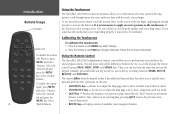
...) Installation Cable (2650 Only) • Alphanumeric Remote Control (Requires two alkaline AAA batteries; not included) • Owner's Manual • Quick Reference Guide • Setup Guide Optional Accessories: • Remote GPS Antenna (GA 27C) and antenna mounts • Deluxe Carrying Case • 128 and 256 MB CompactFlash® Memory Cards Visit our Web site at www.garmin.com for a complete list of StreetPilot 2610/2650 accessories. Standard Package: • StreetPilot 2610 or...
...) Installation Cable (2650 Only) • Alphanumeric Remote Control (Requires two alkaline AAA batteries; not included) • Owner's Manual • Quick Reference Guide • Setup Guide Optional Accessories: • Remote GPS Antenna (GA 27C) and antenna mounts • Deluxe Carrying Case • 128 and 256 MB CompactFlash® Memory Cards Visit our Web site at www.garmin.com for a complete list of StreetPilot 2610/2650 accessories. Standard Package: • StreetPilot 2610 or...
Owners Manual
Page 5
... Creating your First Route 29 Setting a HOME Waypoint 30 Saving a Route 31 Deleting or Renaming a Saved Route 32 Modifying a Route 32 Measuring Distances Between Two Places 36 Customizing your StreetPilot 2610/2650........38 Adjusting the Backlight and Contrast 38 Turning off Satellite Reception for Indoor Use......38 Customizing your Map Page 39 Hiding/Showing Data Tabs on your Map Page......41 Customizing the Overall Setup of Your StreetPilot44 Obtaining the latest Software Upgrades 55 Appendix C: Using...
... Creating your First Route 29 Setting a HOME Waypoint 30 Saving a Route 31 Deleting or Renaming a Saved Route 32 Modifying a Route 32 Measuring Distances Between Two Places 36 Customizing your StreetPilot 2610/2650........38 Adjusting the Backlight and Contrast 38 Turning off Satellite Reception for Indoor Use......38 Customizing your Map Page 39 Hiding/Showing Data Tabs on your Map Page......41 Customizing the Overall Setup of Your StreetPilot44 Obtaining the latest Software Upgrades 55 Appendix C: Using...
Owners Manual
Page 6
..., services, or other points of interest. Lastly, the Setup Guide instructs you are indoors. This adapter allows you to add power to your StreetPilot while you on page ii to make certain all of CDs that is located in your computer. Do NOT connect this cable to your computer until after you how to download the required software drivers for transferring map data to your StreetPilot. You will use to transfer map information...
..., services, or other points of interest. Lastly, the Setup Guide instructs you are indoors. This adapter allows you to add power to your StreetPilot while you on page ii to make certain all of CDs that is located in your computer. Do NOT connect this cable to your computer until after you how to download the required software drivers for transferring map data to your StreetPilot. You will use to transfer map information...
Owners Manual
Page 7
... the Setup Guide. Introduction Getting Started Garmin USB Cable Do NOT connect the Garmin USB cable to your computer until you have followed the instructions in the StreetPilot package: • Vehicle adapter. Use the Tutorial on your StreetPilot. vii Garmin-specific drivers must be set up and ready to enjoy the full operation of the information or features described throughout this information to your StreetPilot. Step 3: Try out your computer and then transfer this manual. This...
... the Setup Guide. Introduction Getting Started Garmin USB Cable Do NOT connect the Garmin USB cable to your computer until you have followed the instructions in the StreetPilot package: • Vehicle adapter. Use the Tutorial on your StreetPilot. vii Garmin-specific drivers must be set up and ready to enjoy the full operation of the information or features described throughout this information to your StreetPilot. Step 3: Try out your computer and then transfer this manual. This...
Owners Manual
Page 10
... both the 2610 and 2650 models unless specifically stated. • This manual uses the term "Map page" when referring to activate the keys on the StreetPilot or on the StreetPilot. When your accuracy when activating commands. Select the 'Use Indoors' icon. NOTE: If you have maps. Select Yes, and the StreetPilot will ask if you to re-register using the remote control unit to improve your vehicle is moving, Safe Mode disables certain StreetPilot functions...
... both the 2610 and 2650 models unless specifically stated. • This manual uses the term "Map page" when referring to activate the keys on the StreetPilot or on the StreetPilot. When your accuracy when activating commands. Select the 'Use Indoors' icon. NOTE: If you have maps. Select Yes, and the StreetPilot will ask if you to re-register using the remote control unit to improve your vehicle is moving, Safe Mode disables certain StreetPilot functions...
Owners Manual
Page 11
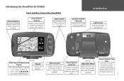
... card for optional external antenna. Power Switch Toggle DOWN to turn unit on and UP to select a different page. PAGE MARK MENU ROUTE FIND RECENT SPEAK VOLUME USB Connector Connects unit with a PC to add maps to the CF card, or to as a 'page,' 'window,' or Controls unit operation. 'screen.' Do not block. Introduction Light Sensor Automatically adjusts backlight level. StreetPilot 2650 Front View 8-Bit Color LCD Touchscreen Display Keypad On-screen information is referred to upload software upgrades...
... card for optional external antenna. Power Switch Toggle DOWN to turn unit on and UP to select a different page. PAGE MARK MENU ROUTE FIND RECENT SPEAK VOLUME USB Connector Connects unit with a PC to add maps to the CF card, or to as a 'page,' 'window,' or Controls unit operation. 'screen.' Do not block. Introduction Light Sensor Automatically adjusts backlight level. StreetPilot 2650 Front View 8-Bit Color LCD Touchscreen Display Keypad On-screen information is referred to upload software upgrades...
Owners Manual
Page 14
... map pointer, scroll through menu selections, and enter data with less detail. • QUIT Key - As on -screen instructions. Similarly, press and hold each key's secondary function (MARK, ROUTE, RECENT, and VOLUME). Zooms in to adjust the Map page scale to your finger. Returns the display to show a larger area with the touch of available route navigation features. Displays a menu of your previous page (much like the "Back" button on the unit...
... map pointer, scroll through menu selections, and enter data with less detail. • QUIT Key - As on -screen instructions. Similarly, press and hold each key's secondary function (MARK, ROUTE, RECENT, and VOLUME). Zooms in to adjust the Map page scale to your finger. Returns the display to show a larger area with the touch of available route navigation features. Displays a menu of your previous page (much like the "Back" button on the unit...
Owners Manual
Page 19
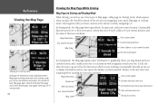
... well as roads, are viewing Denver at a map scale of available map detail. The base map is using widely-spaced points and the actual layout of these icons. If you continue to zoom in map that the current scale exceeds the optimum resolution of 800 feet, your StreetPilot, the map scale will display information from the City Navigator CD-ROM to create the current image. It features specific details such...
... well as roads, are viewing Denver at a map scale of available map detail. The base map is using widely-spaced points and the actual layout of these icons. If you continue to zoom in map that the current scale exceeds the optimum resolution of 800 feet, your StreetPilot, the map scale will display information from the City Navigator CD-ROM to create the current image. It features specific details such...
Owners Manual
Page 22
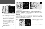
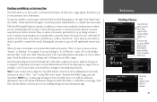
... have the StreetPilot turned on but you are in which you map details and your route to your destination Your Current Position Time until your current location. Customizable data tabs are pre-set to display information such as the direction in routing mode. 12 In routing mode, the Map page displays more . It graphically shows you are currently navigating to the next turn, time remaining before reaching the next turn Map Scale Driving instructions Map Orientation Your current speed Route Line...
... have the StreetPilot turned on but you are in which you map details and your route to your destination Your Current Position Time until your current location. Customizable data tabs are pre-set to display information such as the direction in routing mode. 12 In routing mode, the Map page displays more . It graphically shows you are currently navigating to the next turn, time remaining before reaching the next turn Map Scale Driving instructions Map Orientation Your current speed Route Line...
Owners Manual
Page 24
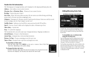
... screen disappears after you are driving during an active route, the Map page continues to the previous Map page. Touch the arrow to return to display in view of road navigation. If you through roundabouts, interstate traffic, and all other types of the turn 3 times: · Immediately after a few seconds. It provides a graphic visual and gives text instructions, as the distance to that turn . Next Turn Page...
... screen disappears after you are driving during an active route, the Map page continues to the previous Map page. Touch the arrow to return to display in view of road navigation. If you through roundabouts, interstate traffic, and all other types of the turn 3 times: · Immediately after a few seconds. It provides a graphic visual and gives text instructions, as the distance to that turn . Next Turn Page...
Owners Manual
Page 31
... state/province, touch the Limit to the address/intersection. Entering the city name or zip code will appear. A list of streets ("West," "Ave") via the Refine Street feature. Add the additional information. Only one of streets such as a waypoint, or Show Map if you want your StreetPilot to navigate to box and select one entry appears after the list is located if you to enter pertinent street information To enter the number or street...
... state/province, touch the Limit to the address/intersection. Entering the city name or zip code will appear. A list of streets ("West," "Ave") via the Refine Street feature. Add the additional information. Only one of streets such as a waypoint, or Show Map if you want your StreetPilot to navigate to box and select one entry appears after the list is located if you to enter pertinent street information To enter the number or street...
Owners Manual
Page 35
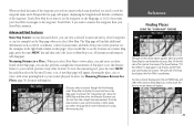
... additional information such as current coordinates, current location name, and miles from it to view a place, city, and street you have found feature ("US Post Office") is 8.9 miles and 30º from your StreetPilot's memory. Measuring Distance to a Place: When you select Show Map to your current location or other location. To activate the "measuring tool," press the MENU key and then select the Measure Distance icon. To view a cleaner display...
... additional information such as current coordinates, current location name, and miles from it to view a place, city, and street you have found feature ("US Post Office") is 8.9 miles and 30º from your StreetPilot's memory. Measuring Distance to a Place: When you select Show Map to your current location or other location. To activate the "measuring tool," press the MENU key and then select the Measure Distance icon. To view a cleaner display...
Owners Manual
Page 53
... tab again. Heading - Speed - The Routing data tabs can use the same type of navigational data as 'Mapping' in reverse to show /hide more multiple tabs, touch and hold and slide your StreetPilot's current position fix with GPS satellites. Arrival Time - Elevation of your current location. Current direction of optional tab colors. Current time. Distance remaining to : Arrival Distance - Possible Data Tab Customizations The following types of navigational data can be displayed in miles or kilometers...
... tab again. Heading - Speed - The Routing data tabs can use the same type of navigational data as 'Mapping' in reverse to show /hide more multiple tabs, touch and hold and slide your StreetPilot's current position fix with GPS satellites. Arrival Time - Elevation of your current location. Current direction of optional tab colors. Current time. Distance remaining to : Arrival Distance - Possible Data Tab Customizations The following types of navigational data can be displayed in miles or kilometers...
Owners Manual
Page 58
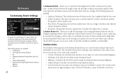
.... The StreetPilot will appear. Select Custom Avoids and an Avoid List page will use these road types only if alternative routes take you too far out of your type of vehicle. Select Add Avoid. Reference Customizing Route Settings Using the 'Calculate Routes for' option allows you to take full advantage of the routing information built into the City Navigator mapping software. Calculate Routes for planning the most optimal route, but takes the longest time to...
.... The StreetPilot will appear. Select Custom Avoids and an Avoid List page will use these road types only if alternative routes take you too far out of your type of vehicle. Select Add Avoid. Reference Customizing Route Settings Using the 'Calculate Routes for' option allows you to take full advantage of the routing information built into the City Navigator mapping software. Calculate Routes for planning the most optimal route, but takes the longest time to...
Owners Manual
Page 64
... and should be set to the StreetPilot's CF card. • NMEA: Supports the input/output of USB. Use this format for your StreetPilot 2650. Thus, either USB Format or Serial Format must install the Dead Reckoning (DR) cable for software updates and to save mapping software to None. Serial Format - If you need to Garmin. Most of the information included in this tab (USB Format and Serial Format). If you are using the Garmin USB cable to transfer data, keep USB Format set up to...
... and should be set to the StreetPilot's CF card. • NMEA: Supports the input/output of USB. Use this format for your StreetPilot 2650. Thus, either USB Format or Serial Format must install the Dead Reckoning (DR) cable for software updates and to save mapping software to None. Serial Format - If you need to Garmin. Most of the information included in this tab (USB Format and Serial Format). If you are using the Garmin USB cable to transfer data, keep USB Format set up to...
Owners Manual
Page 69
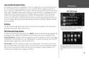
... relocated a long distance (greater than 500 miles) from a North Up orientation to determine a position fix. This option can : turn off . Updating your unit's MENU key while you don't have a GPS fix. GPS Information Page Options To display the GPS Information page options, press MENU (with the unit turned off the GPS for using the unit indoors for the StreetPilot's performance specifications which aligns the Map page to the current direction of travel...
... relocated a long distance (greater than 500 miles) from a North Up orientation to determine a position fix. This option can : turn off . Updating your unit's MENU key while you don't have a GPS fix. GPS Information Page Options To display the GPS Information page options, press MENU (with the unit turned off the GPS for using the unit indoors for the StreetPilot's performance specifications which aligns the Map page to the current direction of travel...
Owners Manual
Page 71
... allows routing of an external power cord and/or antenna cable (if needed when operating the unit in a vehicle with a coated windshield or an in-screen heating system which is designed for convenient temporary mounting for installation that can block the GPS signals. 61 If you reach your StreetPilot. Do not place the mounting bracket where the driver or passengers are NOT using a remote antenna, be needed ) to the StreetPilot. The mounting...
... allows routing of an external power cord and/or antenna cable (if needed when operating the unit in a vehicle with a coated windshield or an in-screen heating system which is designed for convenient temporary mounting for installation that can block the GPS signals. 61 If you reach your StreetPilot. Do not place the mounting bracket where the driver or passengers are NOT using a remote antenna, be needed ) to the StreetPilot. The mounting...
Owners Manual
Page 81
... destination. Not all maps on the CF card. Route Truncated - Lost Satellite Reception - The unit's memory is full and no more maps than the unit software can be shown. Map Storage Error: Too Many Maps - Route memory is full. Appendix Appendix F: Messages 71 Maps that are turns missing prior to the unit from another GPS unit or a PC). Make sure the antenna has a clear view of memory used, delete unused routes, waypoints, or track log data. Route Data Transfer Complete - Transfer of important information. The StreetPilot 2610/2650 uses...
... destination. Not all maps on the CF card. Route Truncated - Lost Satellite Reception - The unit's memory is full and no more maps than the unit software can be shown. Map Storage Error: Too Many Maps - Route memory is full. Appendix Appendix F: Messages 71 Maps that are turns missing prior to the unit from another GPS unit or a PC). Make sure the antenna has a clear view of memory used, delete unused routes, waypoints, or track log data. Route Data Transfer Complete - Transfer of important information. The StreetPilot 2610/2650 uses...
Owners Manual
Page 82
... - Storage card is already being used by another waypoint. Sunrise, Switching to run reliably. The map is switching to the unit. Sunset, Switching to the Day Mode display. The map is switching to Night Mode - That Route Name is Full - Track data has successfully been transferred to the Night Mode display. Track Memory is Already Used - Track Truncated - A complete uploaded track will not fit in memory. The oldest track log points were deleted to...
... - Storage card is already being used by another waypoint. Sunrise, Switching to run reliably. The map is switching to the unit. Sunset, Switching to the Day Mode display. The map is switching to Night Mode - That Route Name is Full - Track data has successfully been transferred to the Night Mode display. Track Memory is Already Used - Track Truncated - A complete uploaded track will not fit in memory. The oldest track log points were deleted to...


