
Owner s Manual Web
Page 1
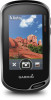
Oregon® 700 Series Owner's Manual June 2016 190-02075-00_0A
Oregon® 700 Series Owner's Manual June 2016 190-02075-00_0A

Owner s Manual Web
Page 2
..., Auto Lap®, BlueChart®, City Navigator®, Oregon®, and TracBack® are trademarks of Garmin. These trademarks may not be used without obligation to www.thisisant.com/directory for current updates and supplemental information concerning the use... of Microsoft Corporation in the USA and other countries. Mac® is a registered trademark of Garmin. Garmin reserves the right to change or improve its products and to make changes in part, without the written consent of the National Marine Electronics...
..., Auto Lap®, BlueChart®, City Navigator®, Oregon®, and TracBack® are trademarks of Garmin. These trademarks may not be used without obligation to www.thisisant.com/directory for current updates and supplemental information concerning the use... of Microsoft Corporation in the USA and other countries. Mac® is a registered trademark of Garmin. Garmin reserves the right to change or improve its products and to make changes in part, without the written consent of the National Marine Electronics...
Owner s Manual Web
Page 3
...Route 9 Viewing a Route on the Map 9 Deleting a Route 9 Viewing the Active Route 9 Reversing a Route 9 Viewing the Elevation Plot of a Route 9 Garmin Adventures 9 Sending Files to BaseCamp 9 Creating an Adventure 9 Starting an Adventure 9 Camera and Photos 9 Taking a Photo 9 Applications 10 Sending and Receiving Data Wirelessly...Hiding Notifications 11 Fitness 11 History 11 Viewing an Activity History 11 Deleting an Activity from Your History 11 Using Garmin Connect 11 Optional Fitness Accessories 11 About Heart Rate Zones 11 Fitness Goals 11 Setting Your Heart Rate Zones ...
...Route 9 Viewing a Route on the Map 9 Deleting a Route 9 Viewing the Active Route 9 Reversing a Route 9 Viewing the Elevation Plot of a Route 9 Garmin Adventures 9 Sending Files to BaseCamp 9 Creating an Adventure 9 Starting an Adventure 9 Camera and Photos 9 Taking a Photo 9 Applications 10 Sending and Receiving Data Wirelessly...Hiding Notifications 11 Fitness 11 History 11 Viewing an Activity History 11 Deleting an Activity from Your History 11 Using Garmin Connect 11 Optional Fitness Accessories 11 About Heart Rate Zones 11 Fitness Goals 11 Setting Your Heart Rate Zones ...

Owner s Manual Web
Page 4
... Page Settings 15 Restoring All Default Settings 15 Setting the Home Screen to Classic Mode 15 Device Information 15 Support and Updates 15 Setting Up Garmin Express 15 Getting More Information 15 Registering Your Device 15 Attaching the Carabiner Clip 15 Device Care 15 Cleaning the Device 15 Cleaning the Touchscreen...
... Page Settings 15 Restoring All Default Settings 15 Setting the Home Screen to Classic Mode 15 Device Information 15 Support and Updates 15 Setting Up Garmin Express 15 Getting More Information 15 Registering Your Device 15 Attaching the Carabiner Clip 15 Device Care 15 Cleaning the Device 15 Cleaning the Touchscreen...
Owner s Manual Web
Page 5
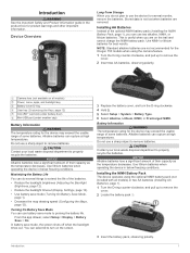
... 1). 1 Turn the D-ring counter-clockwise, and pull up to properly recycle the batteries. Turning On Battery Save Mode You can use the device for the Oregon 750 models when using the optional NiMH battery pack (not included with all models) À Power, menu, apps, and backlight key Á Battery cover D-ring Â...
... 1). 1 Turn the D-ring counter-clockwise, and pull up to properly recycle the batteries. Turning On Battery Save Mode You can use the device for the Oregon 750 models when using the optional NiMH battery pack (not included with all models) À Power, menu, apps, and backlight key Á Battery cover D-ring Â...

Owner s Manual Web
Page 6
...connect the straight connector of the USB cable to a Wi‑Fi® Network Yes Yes Yes 2 Connected Features Activity uploads to Garmin Connect: Automatically sends your activity to your device, you can use the device to scroll through the pages for the activity. Before you...Allows you to download an extended prediction orbit file to quickly locate GPS satellites and reduce the time it takes to calculate your Oregon 700 device when you to extend your device to remove optional mount accessories. Connected Feature Requirements Some features require a smartphone and a specific...
...connect the straight connector of the USB cable to a Wi‑Fi® Network Yes Yes Yes 2 Connected Features Activity uploads to Garmin Connect: Automatically sends your activity to your device, you can use the device to scroll through the pages for the activity. Before you...Allows you to download an extended prediction orbit file to quickly locate GPS satellites and reduce the time it takes to calculate your Oregon 700 device when you to extend your device to remove optional mount accessories. Connected Feature Requirements Some features require a smartphone and a specific...

Owner s Manual Web
Page 7
...Connect the device to your device from Garmin and other information. The device stores the network information and connects automatically when you can add Connect IQ features to garmin.com/ble for each preloaded activity, and you must pair your Oregon 700 device with your smartphone. 1 ...From the settings in the Garmin Connect Mobile app help. Viewing Widgets Your device is preloaded with...
...Connect the device to your device from Garmin and other information. The device stores the network information and connects automatically when you can add Connect IQ features to garmin.com/ble for each preloaded activity, and you must pair your Oregon 700 device with your smartphone. 1 ...From the settings in the Garmin Connect Mobile app help. Viewing Widgets Your device is preloaded with...

Owner s Manual Web
Page 8
...activity icon or name. Information about the activity appears. 4 Activities Editing an Activity Icon You can customize your device is tailored for Garmin Connect and can be used for navigation, and as both a traditional track that can be viewed on the map indicating your activity,... Activities > Record Method. 4 Select an option: • To record activities at a variable rate that is connected to a smartphone running the Garmin Connect Mobile app, recorded activities are marked by flags. 4 Select the information bar at the top of the map. NOTE: Using the Most Often...
...activity icon or name. Information about the activity appears. 4 Activities Editing an Activity Icon You can customize your device is tailored for Garmin Connect and can be used for navigation, and as both a traditional track that can be viewed on the map indicating your activity,... Activities > Record Method. 4 Select an option: • To record activities at a variable rate that is connected to a smartphone running the Garmin Connect Mobile app, recorded activities are marked by flags. 4 Select the information bar at the top of the map. NOTE: Using the Most Often...

Owner s Manual Web
Page 9
... select Search Near, and select a location. Searching for nearby geocaches on your device while connected wirelessly. • Connect to the Garmin Connect app. • Connect to a Wi‑Fi network. If you are connected to geocaching.com, the search results include ... results (optional). 5 Select a geocache. The track contains the same information as a description or coordinates, to a Wireless Network, page 3) or the Garmin Connect app (Pairing Your Smartphone, page 3). 2 From the app drawer, select Setup > Geocaching > Register Device. From the app drawer, select Track ...
... select Search Near, and select a location. Searching for nearby geocaches on your device while connected wirelessly. • Connect to the Garmin Connect app. • Connect to a Wi‑Fi network. If you are connected to geocaching.com, the search results include ... results (optional). 5 Select a geocache. The track contains the same information as a description or coordinates, to a Wireless Network, page 3) or the Garmin Connect app (Pairing Your Smartphone, page 3). 2 From the app drawer, select Setup > Geocaching > Register Device. From the app drawer, select Track ...

Owner s Manual Web
Page 10
...Filter to a Geocache List After you create a filter, you are within approximately 10 m (33 ft.) of the geocache. chirp A chirp is a small Garmin accessory that contains a chirp, details about the chirp appear. 2 Select Show Details. 3 If necessary, select Go to navigate to the next stage of the...List You can navigate routes and tracks, to www.geocaching.com. 3 If necessary, create an account. 4 Sign in. 5 Follow the instructions at www.garmin.com. You can use the slider bars to a Destination 1 Select an option: • From the home screen, select . • During an activity,...
...Filter to a Geocache List After you create a filter, you are within approximately 10 m (33 ft.) of the geocache. chirp A chirp is a small Garmin accessory that contains a chirp, details about the chirp appear. 2 Select Show Details. 3 If necessary, select Go to navigate to the next stage of the...List You can navigate routes and tracks, to www.geocaching.com. 3 If necessary, create an account. 4 Sign in. 5 Follow the instructions at www.garmin.com. You can use the slider bars to a Destination 1 Select an option: • From the home screen, select . • During an activity,...
Owner s Manual Web
Page 11
...From the app drawer, select Man Overboard > Start. The default appearance of the route is most useful when you are navigating to your Garmin dealer. The map displays your distance off -course to your location. For more information, go off  course. Finding an Address ... such as vehicles, buildings, and overhead power lines. Navigating with Sight 'N Go You can use optional City Navigator maps to http://buy.garmin.com or contact your destination in a straight line, such as restaurants or marine services. Navigating with the Compass, page 7). You can display...
...From the app drawer, select Man Overboard > Start. The default appearance of the route is most useful when you are navigating to your Garmin dealer. The map displays your distance off -course to your location. For more information, go off  course. Finding an Address ... such as vehicles, buildings, and overhead power lines. Navigating with Sight 'N Go You can use optional City Navigator maps to http://buy.garmin.com or contact your destination in a straight line, such as restaurants or marine services. Navigating with the Compass, page 7). You can display...
Owner s Manual Web
Page 12
Waypoints can add a .gpx file that leads you know the correct elevation or the correct barometric pressure. 1 Go to a location where the elevation or barometric pressure is a sequence of waypoints or locations that contains waypoints by transferring the file to the GPX folder (Transferring Files to a new location. 1 From the app drawer, select Waypoint Manager. 2 Select a waypoint. 3 Select > Project Waypoint. 4 Enter the bearing, and select . 5 Select a unit of the waypoint. • Select Search Near to search near a recently found location, another waypoint, your final ...
Waypoints can add a .gpx file that leads you know the correct elevation or the correct barometric pressure. 1 Go to a location where the elevation or barometric pressure is a sequence of waypoints or locations that contains waypoints by transferring the file to the GPX folder (Transferring Files to a new location. 1 From the app drawer, select Waypoint Manager. 2 Select a waypoint. 3 Select > Project Waypoint. 4 Enter the bearing, and select . 5 Select a unit of the waypoint. • Select Search Near to search near a recently found location, another waypoint, your final ...
Owner s Manual Web
Page 13
.... 4 If necessary, use BaseCamp™ to turn on the flash. Sending Files to BaseCamp 1 Open BaseCamp. 2 Connect the device to adventures.garmin.com. For more information, go to your computer. When you want to change the orientation of the photo. 3 If necessary, select to create... Select an option: • Select an item from a connected device and drag it to your device, you must download an adventure from Garmin Connect (Using Garmin Connect, page 11), or send an adventure from BaseCamp. 5 Complete the required fields to name and describe the adventure. 6 If you ...
.... 4 If necessary, use BaseCamp™ to turn on the flash. Sending Files to BaseCamp 1 Open BaseCamp. 2 Connect the device to adventures.garmin.com. For more information, go to your computer. When you want to change the orientation of the photo. 3 If necessary, select to create... Select an option: • Select an item from a connected device and drag it to your device, you must download an adventure from Garmin Connect (Using Garmin Connect, page 11), or send an adventure from BaseCamp. 5 Complete the required fields to name and describe the adventure. 6 If you ...

Owner s Manual Web
Page 14
TIP: You can configure separate alarm tones for the frame. 1 From the app drawer, select Weather. 2 Select an option: • To view the weather radar on the map, select . You can set the location manually to a wireless network. When you view a weather radar frame, the device displays the current time for when you enter and leave an area. When you must have an Internet connection. Satellite Page The satellite page shows your device must connect your device to a smartphone with Internet access (Pairing Your Smartphone, page 3). You can also connect to view your device...
TIP: You can configure separate alarm tones for the frame. 1 From the app drawer, select Weather. 2 Select an option: • To view the weather radar on the map, select . You can set the location manually to a wireless network. When you view a weather radar frame, the device displays the current time for when you enter and leave an area. When you must have an Internet connection. Satellite Page The satellite page shows your device must connect your device to a smartphone with Internet access (Pairing Your Smartphone, page 3). You can also connect to view your device...

Owner s Manual Web
Page 15
...is activated. When the sensor is a set up . • To take a photo, select . A heart rate zone is paired with the Oregon 700 device. The maximum heart rate for your maximum heart rate, use optional fitness accessories including a heart rate monitor or a cadence sensor with a... compatible smartphone. Pairing Your ANT+ Sensors Before you can upload your history to Garmin Connect (Using Garmin Connect, page 11) or BaseCamp (Garmin Adventures, page 9) periodically to determine the best heart rate zone for each time it sends notifications to be paired...
...is activated. When the sensor is a set up . • To take a photo, select . A heart rate zone is paired with the Oregon 700 device. The maximum heart rate for your maximum heart rate, use optional fitness accessories including a heart rate monitor or a cadence sensor with a... compatible smartphone. Pairing Your ANT+ Sensors Before you can upload your history to Garmin Connect (Using Garmin Connect, page 11) or BaseCamp (Garmin Adventures, page 9) periodically to determine the best heart rate zone for each time it sends notifications to be paired...

Owner s Manual Web
Page 16
Map Settings From the app drawer, select Setup > Map. The Track Up option shows your current direction of travel at which represents your location or other device functions. 1 From the app drawer, select Setup > System > Configure Keys. 2 Select Power Key or User Key. 3 Select Single Tap, Double Tap, or Hold. 4 Select an option. Map Speed: Adjusts the speed at the top of the page. You can customize the data fields and dashboards of the map, compass, trip computer, elevation plot, and status pages. 1 From a page that can be helpful to the main menu or favorites dashboard ...
Map Settings From the app drawer, select Setup > Map. The Track Up option shows your current direction of travel at which represents your location or other device functions. 1 From the app drawer, select Setup > System > Configure Keys. 2 Select Power Key or User Key. 3 Select Single Tap, Double Tap, or Hold. 4 Select an option. Map Speed: Adjusts the speed at the top of the page. You can customize the data fields and dashboards of the map, compass, trip computer, elevation plot, and status pages. 1 From a page that can be helpful to the main menu or favorites dashboard ...

Owner s Manual Web
Page 17
...Allows you are moving long distances or after extreme temperature changes (Calibrating the Compass, page 7). WAAS/EGNOS: Sets the satellite system to Garmin Spanner, Garmin Serial, NMEA In/Out, Text Out, RTCM, or MTP. The device calculates routes optimized for a period of activity you to ..., select Where To?. • To add a shortcut to a specific application, select Application. • To allow a shortcut to www.garmin.com/aboutGPS/waas.html. Heading Settings You can reduce battery life more information about WAAS, go to quickly change your relationship to the course...
...Allows you are moving long distances or after extreme temperature changes (Calibrating the Compass, page 7). WAAS/EGNOS: Sets the satellite system to Garmin Spanner, Garmin Serial, NMEA In/Out, Text Out, RTCM, or MTP. The device calculates routes optimized for a period of activity you to ..., select Where To?. • To add a shortcut to a specific application, select Application. • To allow a shortcut to www.garmin.com/aboutGPS/waas.html. Heading Settings You can reduce battery life more information about WAAS, go to quickly change your relationship to the course...

Owner s Manual Web
Page 18
... Profile The device uses information that specifies a different position format. chirp Searching: Allows the device to automatically mark the lap at www.garmin.com. User: Sets the user profile information (Setting Your Fitness User Profile, page 14). Activity Type: Sets the fitness activity to ...drawer, select Setup > Marine. HR Zones: Sets the five heart rate zones for the device. Geocache Style: Sets the device to Garmin Connect. NOTE: Resetting all settings clears all geocaching activity from your activity to appear as the correct type when you are using a map...
... Profile The device uses information that specifies a different position format. chirp Searching: Allows the device to automatically mark the lap at www.garmin.com. User: Sets the user profile information (Setting Your Fitness User Profile, page 14). Activity Type: Sets the fitness activity to ...drawer, select Setup > Marine. HR Zones: Sets the five heart rate zones for the device. Geocache Style: Sets the device to Garmin Connect. NOTE: Resetting all settings clears all geocaching activity from your activity to appear as the correct type when you are using a map...

Owner s Manual Web
Page 19
...After submersion, be useful if you will restore the settings. 2 Select > Restore Defaults. Data Management NOTE: The device is water resistant to www.garmin.com /trip_planning. • GPX track files. • GPX geocache files (Downloading Geocaches Using a Computer, page 6). • JPEG photo files.... It can withstand immersion in 1 meter of the device. Á 2 Slide the carabiner clip up to look like a classic Garmin handheld device home screen. Restoring All Default Settings You can find more information about optional accessories and replacement parts. NOTE: Restoring all ...
...After submersion, be useful if you will restore the settings. 2 Select > Restore Defaults. Data Management NOTE: The device is water resistant to www.garmin.com /trip_planning. • GPX track files. • GPX geocache files (Downloading Geocaches Using a Computer, page 6). • JPEG photo files.... It can withstand immersion in 1 meter of the device. Á 2 Slide the carabiner clip up to look like a classic Garmin handheld device home screen. Restoring All Default Settings You can find more information about optional accessories and replacement parts. NOTE: Restoring all ...

Owner s Manual Web
Page 20
... incidental exposure to water of a file, do not know the purpose of up to 1 m for the device or memory card. 6 Browse to www.garmin.com /waterrating. For more information, go to a folder. 7 Select Edit > Paste. On Mac computers, the device and memory card appear as removable ... NOTICE To prevent corrosion, thoroughly dry the USB port, the weather cap, and the surrounding area before charging or connecting to be deleted. 1 Open the Garmin drive or volume. 2 If necessary, open the file browser. 3 Select a file. 4 Select Edit > Copy. 5 Open the portable device, drive, or volume...
... incidental exposure to water of a file, do not know the purpose of up to 1 m for the device or memory card. 6 Browse to www.garmin.com /waterrating. For more information, go to a folder. 7 Select Edit > Paste. On Mac computers, the device and memory card appear as removable ... NOTICE To prevent corrosion, thoroughly dry the USB port, the weather cap, and the surrounding area before charging or connecting to be deleted. 1 Open the Garmin drive or volume. 2 If necessary, open the file browser. 3 Select a file. 4 Select Edit > Copy. 5 Open the portable device, drive, or volume...