Owner's Manual
Page 14
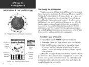
...see a sky view array of the satellites overhead with your GPSmap 60: 1. A bar graph displays the strength of signals from your original location, it takes only seconds to determine your general location so the GPSmap 60 can use your position. Thereafter, if you haven't moved more ...the horizon and the inner circle a position 45o from the options menu, then you use the Map Page to minutes. GPSmap 60 Getting Started Initialization & the Satellite Page The GPSmap 60 locates satellites above your unit. This process is searching for this first initialization, select "...
...see a sky view array of the satellites overhead with your GPSmap 60: 1. A bar graph displays the strength of signals from your original location, it takes only seconds to determine your general location so the GPSmap 60 can use your position. Thereafter, if you haven't moved more ...the horizon and the inner circle a position 45o from the options menu, then you use the Map Page to minutes. GPSmap 60 Getting Started Initialization & the Satellite Page The GPSmap 60 locates satellites above your unit. This process is searching for this first initialization, select "...
Owner's Manual
Page 23
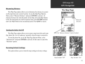
...of roadways, especially when the map is zoomed in. Measuring Distance This Map Page option allows you to determine the distance to a point on the Map, move the Map Pointer to the second map point. Do the same to cancel. GPSmap 60 GPS Navigation The Map Page Measured Distance Turning Declutter... On/Off This Map Page option allows you to return the map settings to factory settings. The "Measure Distance...
...of roadways, especially when the map is zoomed in. Measuring Distance This Map Page option allows you to determine the distance to a point on the Map, move the Map Pointer to the second map point. Do the same to cancel. GPSmap 60 GPS Navigation The Map Page Measured Distance Turning Declutter... On/Off This Map Page option allows you to return the map settings to factory settings. The "Measure Distance...
Owner's Manual
Page 25
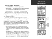
...Highlight your destination. When you drift away from the line of your movement and the direction to your selection and press ENTER. 5. The second option is "Data Fields." Highlight the data fields option and press ENTER to page 11 for details on the page will appear. GPSmap... 60 GPS Navigation The Compass Page Compass Page Options Menu Course Deviation Distance Course Deviation Indicator (CDI) Course Pointer Option Change Data Fields Option ...
...Highlight your destination. When you drift away from the line of your movement and the direction to your selection and press ENTER. 5. The second option is "Data Fields." Highlight the data fields option and press ENTER to page 11 for details on the page will appear. GPSmap... 60 GPS Navigation The Compass Page Compass Page Options Menu Course Deviation Distance Course Deviation Indicator (CDI) Course Pointer Option Change Data Fields Option ...

Owner's Manual
Page 51
...To preview the turns for an Active Route: 1. Using the "Follow Roads" option from the Map or Compass Page and press ENTER. The view any individual turn and guidance text and a small field at the second warning beep, when you are navigating a route, a guidance message and graphic view of an ...Page. The page displays the turn on the route, press the QUIT key to highlight it to display the Route Page for the route. 2. GPSmap 60 GPS Navigation Navigating a Route After you have created a route, you can view only the list of Turns for an Active Route using the "Follow...
...To preview the turns for an Active Route: 1. Using the "Follow Roads" option from the Map or Compass Page and press ENTER. The view any individual turn and guidance text and a small field at the second warning beep, when you are navigating a route, a guidance message and graphic view of an ...Page. The page displays the turn on the route, press the QUIT key to highlight it to display the Route Page for the route. 2. GPSmap 60 GPS Navigation Navigating a Route After you have created a route, you can view only the list of Turns for an Active Route using the "Follow...

Owner's Manual
Page 60
...Arrow to display on the nearest road, compensating for variances in map position accuracy. GPSmap 60 GPS Navigation Map Setup The "General Settings" Map Setup Page The "Tracks Settings" Map Setup Page The "Points Settings" Map Setup Page 50 Map Setup - Map Setup - You can set it to Auto or select a...the map setup feature allows you determine the map scale at which various map features display. Use this page to the North Up map orientation. General Settings The first page of the Map Setup feature is the General Settings Page. Tracks Settings The second page of the Map ...
...Arrow to display on the nearest road, compensating for variances in map position accuracy. GPSmap 60 GPS Navigation Map Setup The "General Settings" Map Setup Page The "Tracks Settings" Map Setup Page The "Points Settings" Map Setup Page 50 Map Setup - Map Setup - You can set it to Auto or select a...the map setup feature allows you determine the map scale at which various map features display. Use this page to the North Up map orientation. General Settings The first page of the Map Setup feature is the General Settings Page. Tracks Settings The second page of the Map ...

Owner's Manual
Page 73
...HINT: Pressing the ENTER key and selecting "Cheat On" will appear on the screen. Enabling this mode will penalize you by five minutes and count seconds by 90 yards (about the size of the maze you how many flags remain. In measured rhythm, Gekos will enable a "cheat mode." Before the... large fields are placed at one time. These levels determine how often Gekos appear. Field size choices are Easy, Normal and Hard. GPSmap 60 GPS Features GPS Enhanced Games 63 The Difficulty Level determines how much of an American football field). If you as difficulty levels increase. The ...
...HINT: Pressing the ENTER key and selecting "Cheat On" will appear on the screen. Enabling this mode will penalize you by five minutes and count seconds by 90 yards (about the size of the maze you how many flags remain. In measured rhythm, Gekos will enable a "cheat mode." Before the... large fields are placed at one time. These levels determine how often Gekos appear. Field size choices are Easy, Normal and Hard. GPSmap 60 GPS Features GPS Enhanced Games 63 The Difficulty Level determines how much of an American football field). If you as difficulty levels increase. The ...

Owner's Manual
Page 78
GPSmap 60 Appendices Specifications 68 PHYSICAL Case: Size: Weight: Display: Antenna: Keypad: Operating Range: Rugged, fully gasketed, water resistant, IEC60529 IPX7 (Submersible 1 meter @ 30 minutes) 6.1"H x 2.4"W x 1.3"D 5.2 ... backlit keys 5 to 158oF (-15 to 70oC)1 PERFORMANCE Receiver: Acquisition Time: Update Rate: GPS Accuracy Position: Velocity: WAAS enabled, 12 parallel channel Warm: Approximately 15 seconds Cold: Approximately 45 seconds AutoLocate™: Approximately 2 minutes Once per second, continuous < 15 meters (49 feet), 95% typical2 0.05 meter/sec steady state
GPSmap 60 Appendices Specifications 68 PHYSICAL Case: Size: Weight: Display: Antenna: Keypad: Operating Range: Rugged, fully gasketed, water resistant, IEC60529 IPX7 (Submersible 1 meter @ 30 minutes) 6.1"H x 2.4"W x 1.3"D 5.2 ... backlit keys 5 to 158oF (-15 to 70oC)1 PERFORMANCE Receiver: Acquisition Time: Update Rate: GPS Accuracy Position: Velocity: WAAS enabled, 12 parallel channel Warm: Approximately 15 seconds Cold: Approximately 45 seconds AutoLocate™: Approximately 2 minutes Once per second, continuous < 15 meters (49 feet), 95% typical2 0.05 meter/sec steady state
Owner's Manual
Page 89
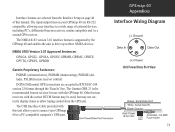
... display status or allow tuning control from the Interface Setup on your GPSmap 60 to three NMEA devices. NMEA 0183 Version 3.01 Approved Sentences: GPGGA, GPGLL, GPGSA, GPGSV, GPRMB, GPRMC, GPRTE, GPVTG, GPWPL, GPBOD Garmin Proprietary Sentences: PGRME (estimated error), PGRMM (datum string), PGRMZ (altitude),... receivers, marine autopilots and /or a second GPS receiver. Interface formats are selected from the GPS unit. Other beacon receivers with this manual. The input/output lines on page 46 of this unit allows you to connect your GPSmap 60 are accepted in RTCM SC-104 version...
... display status or allow tuning control from the Interface Setup on your GPSmap 60 to three NMEA devices. NMEA 0183 Version 3.01 Approved Sentences: GPGGA, GPGLL, GPGSA, GPGSV, GPRMB, GPRMC, GPRTE, GPVTG, GPWPL, GPBOD Garmin Proprietary Sentences: PGRME (estimated error), PGRMM (datum string), PGRMZ (altitude),... receivers, marine autopilots and /or a second GPS receiver. Interface formats are selected from the GPS unit. Other beacon receivers with this manual. The input/output lines on page 46 of this unit allows you to connect your GPSmap 60 are accepted in RTCM SC-104 version...
Quick Start Guide
Page 2
...key repeatedly to cycle from the back of the unit, lift the D-Ring and turn D-Ring clockwise to lock the cover in 15 seconds unless connected to use of each overhead satellite. Trip Computer Page - Provides guidance to cycle through lists, highlight fields, on -screen ...Backlighting and Contrast Lighting conditions may be lost when batteries are fixed (enough to view the GPSmap 60 display. Allow the Adjustment Slider to timeout in place. Displays a map and your location coordinates, position accuracy, a view of the satellites overhead, and a bar graph showing the...
...key repeatedly to cycle from the back of the unit, lift the D-Ring and turn D-Ring clockwise to lock the cover in 15 seconds unless connected to use of each overhead satellite. Trip Computer Page - Provides guidance to cycle through lists, highlight fields, on -screen ...Backlighting and Contrast Lighting conditions may be lost when batteries are fixed (enough to view the GPSmap 60 display. Allow the Adjustment Slider to timeout in place. Displays a map and your location coordinates, position accuracy, a view of the satellites overhead, and a bar graph showing the...


