
Declaration of Conformity
Page 1
Global Positioning System Receiver GPSMAP 60 MONO GPS 60 The undersigned does hereby declare that the equipment complies to which Conformity is Declared: 89/336/EEC, 1999/5/EC EN ..., U.S.A TAIWAN, R.O.C. Paul Morrow Quality Manager GARMIN (Europe) Ltd Date: 20th September 2005 Immunity Standard EN 60950-1:2001 Safety of Information Technology Equipment Manufactured by: Manufacture's Address: Authorised Representative: Type of Council Directive: Standard to the above Directives. Estate, Romsey, Hampshire, SO51 9DL, U.K. GARMIN (Europe) Ltd, The Quadrangle, Abbey Park Ind...
Global Positioning System Receiver GPSMAP 60 MONO GPS 60 The undersigned does hereby declare that the equipment complies to which Conformity is Declared: 89/336/EEC, 1999/5/EC EN ..., U.S.A TAIWAN, R.O.C. Paul Morrow Quality Manager GARMIN (Europe) Ltd Date: 20th September 2005 Immunity Standard EN 60950-1:2001 Safety of Information Technology Equipment Manufactured by: Manufacture's Address: Authorised Representative: Type of Council Directive: Standard to the above Directives. Estate, Romsey, Hampshire, SO51 9DL, U.K. GARMIN (Europe) Ltd, The Quadrangle, Abbey Park Ind...
Owner's Manual
Page 6
...DIRECTION, DISTANCE, LOCATION OR TOPOGRAPHY. CAUTION: The electronic chart is an aid to navigation and is responsible for safe navigation - and, as always, the user is designed to mariners contain all information needed for their prudent use . GPSmap 60 Introduction Warnings and Precautions CAUTION: Use the GPSmap® 60... of unsafe operation, carefully review and understand all available navigation sources, including the information from the GPSmap® 60 to actual use . When in actual use, carefully compare indications from other NAVAIDs, visual sightings, charts, etc.
...DIRECTION, DISTANCE, LOCATION OR TOPOGRAPHY. CAUTION: The electronic chart is an aid to navigation and is responsible for safe navigation - and, as always, the user is designed to mariners contain all information needed for their prudent use . GPSmap 60 Introduction Warnings and Precautions CAUTION: Use the GPSmap® 60... of unsafe operation, carefully review and understand all available navigation sources, including the information from the GPSmap® 60 to actual use . When in actual use, carefully compare indications from other NAVAIDs, visual sightings, charts, etc.

Owner's Manual
Page 15
... to begin GPS-aided navigation. Route - Active Navigation is displayed. GPSmap 60 Getting Started Initialization & The Satellite Page Map Item Details Position Arrow Map Scale Map Pointer Map Page with Current Position Arrow Navigating with a route line, and leaves a trail (track log) of travel data. A direct path to avoid objects that has been stored (logged) in the...
... to begin GPS-aided navigation. Route - Active Navigation is displayed. GPSmap 60 Getting Started Initialization & The Satellite Page Map Item Details Position Arrow Map Scale Map Pointer Map Page with Current Position Arrow Navigating with a route line, and leaves a trail (track log) of travel data. A direct path to avoid objects that has been stored (logged) in the...
Owner's Manual
Page 18
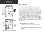
...direction of movement is indicated by following : • Determine your current location and progress while moving. • Select and save a map point as rivers, lakes, highways and towns. You can be changed to "Night" mode for easier viewing in dim light. residential streets, parks, etc.) because Garmin MapSource® detailed mapping... level of the GPSmap 60. It allows you activate the Track Log feature, your current location. GPSmap 60 GPS Navigation The Map Page "North Up" Mode with Map oriented with North at the top The Map Scale The Map Page Position Arrow ...
...direction of movement is indicated by following : • Determine your current location and progress while moving. • Select and save a map point as rivers, lakes, highways and towns. You can be changed to "Night" mode for easier viewing in dim light. residential streets, parks, etc.) because Garmin MapSource® detailed mapping... level of the GPSmap 60. It allows you activate the Track Log feature, your current location. GPSmap 60 GPS Navigation The Map Page "North Up" Mode with Map oriented with North at the top The Map Scale The Map Page Position Arrow ...
Owner's Manual
Page 24
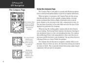
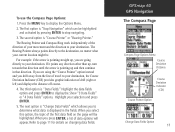
...North. You can choose between a Bearing Pointer or a Course Pointer for navigation. 14 This is especially helpful when using a paper map in each from a list of options. The compass dial and Bearing Pointer work independently to show your destination. Course Pointer The Course Pointer...and directions. It uses a graphic compass display, a bearing pointer and digital data fields to display information such as a magnetic compass when you are stationary. The compass does not function as current speed, distance to the next point on the route, estimated arrival time, etc. GPSmap 60 ...
...North. You can choose between a Bearing Pointer or a Course Pointer for navigation. 14 This is especially helpful when using a paper map in each from a list of options. The compass dial and Bearing Pointer work independently to show your destination. Course Pointer The Course Pointer...and directions. It uses a graphic compass display, a bearing pointer and digital data fields to display information such as a magnetic compass when you are stationary. The compass does not function as current speed, distance to the next point on the route, estimated arrival time, etc. GPSmap 60 ...
Owner's Manual
Page 25
... display the Options Menu. 2. GPSmap 60 GPS Navigation The Compass Page Compass Page Options Menu Course Deviation Distance Course Deviation Indicator (CDI) Course Pointer Option Change Data Fields Option 15 Press the MENU key to display the Show "3 Data Fields" or "4 Data Fields" options. If you are going directly to page 11 for...
... display the Options Menu. 2. GPSmap 60 GPS Navigation The Compass Page Compass Page Options Menu Course Deviation Distance Course Deviation Indicator (CDI) Course Pointer Option Change Data Fields Option 15 Press the MENU key to display the Show "3 Data Fields" or "4 Data Fields" options. If you are going directly to page 11 for...
Owner's Manual
Page 33
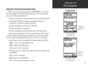
...is a waypoint. • Elevation and depth, if a waypoint. • Direction and distance from the Waypoints list. At the bottom of points on -screen buttons. Go To - save as a Point on the Map Page. display on whether you are three on a route. Use - insert ...press the ENTER key, an Information Page displays with detailed information about the item. GPSmap 60 GPS Navigation Using Find Select as a destination Information Page for a Waypoint Information Page for a Map Item Select as a waypoint. Map - This page contains the following information: • A title (if a waypoint...
...is a waypoint. • Elevation and depth, if a waypoint. • Direction and distance from the Waypoints list. At the bottom of points on -screen buttons. Go To - save as a Point on the Map Page. display on whether you are three on a route. Use - insert ...press the ENTER key, an Information Page displays with detailed information about the item. GPSmap 60 GPS Navigation Using Find Select as a destination Information Page for a Waypoint Information Page for a Map Item Select as a waypoint. Map - This page contains the following information: • A title (if a waypoint...

Owner's Manual
Page 36
...the FIND key to display the Waypoints List. 3. You can be selected as destinations and added as points on Map Page a Waypoint Location To find a Waypoint: 1. GPSmap 60 GPS Navigation Using Find Searching for a Waypoint The Waypoints List is large, you can press the MENU key to ... Waypoint Name and Symbol Enter a notation using the Waypoint Location on-screen keypad Coordinates, Elevation and Depth (if applicable) Distance and Direction from Current Location Navigate to Remove Waypoint from a list of the waypoint in alpha/numerical order and are also identified by a symbol...
...the FIND key to display the Waypoints List. 3. You can be selected as destinations and added as points on Map Page a Waypoint Location To find a Waypoint: 1. GPSmap 60 GPS Navigation Using Find Searching for a Waypoint The Waypoints List is large, you can press the MENU key to ... Waypoint Name and Symbol Enter a notation using the Waypoint Location on-screen keypad Coordinates, Elevation and Depth (if applicable) Distance and Direction from Current Location Navigate to Remove Waypoint from a list of the waypoint in alpha/numerical order and are also identified by a symbol...

Owner's Manual
Page 39
... direction from the list. 5. A list of the services available. Press ENTER to search for the nearest Interstate Exits. 1. Select the Exits icon, then press ENTER to display the Find Menu. This page contains the exit description with a list of the page indicate distance and bearing to highlight the desired exit. GPSmap 60 GPS...
... direction from the list. 5. A list of the services available. Press ENTER to search for the nearest Interstate Exits. 1. Select the Exits icon, then press ENTER to display the Find Menu. This page contains the exit description with a list of the page indicate distance and bearing to highlight the desired exit. GPSmap 60 GPS...

Owner's Manual
Page 44
... log. 4. A track log contains information about and is referred to display the Tracks Page. Then use the ROCKER key to display the Setup page. GPSmap 60 GPS Navigation Using Tracks Tracks Page with new. Press and release the QUIT key until the Main Menu displays. Use a Track Log to "Setup" a...• Measure the area of track log space used. 3. Beneath the Track Log field are four on the map page as you encompass with a track. • Retrace your path in either direction. Press ENTER to as a Track Log. To create a Track Log: 1. The page contains On and Off buttons ...
... log. 4. A track log contains information about and is referred to display the Tracks Page. Then use the ROCKER key to display the Setup page. GPSmap 60 GPS Navigation Using Tracks Tracks Page with new. Press and release the QUIT key until the Main Menu displays. Use a Track Log to "Setup" a...• Measure the area of track log space used. 3. Beneath the Track Log field are four on the map page as you encompass with a track. • Retrace your path in either direction. Press ENTER to as a Track Log. To create a Track Log: 1. The page contains On and Off buttons ...

Owner's Manual
Page 48
GPSmap 60 GPS Navigation Using Tracks TracBack Page Create User Waypoint Prompt 38 To use the ROCKER key to move the Panning Arrow to the desired point on the map and press ENTER to save. When the TracBack Navigation Page appears, directions to the first turn on the track display at the... Page for the track or the Track Log displayed, highlight the TracBack button and press ENTER to display the Mark Waypoint Page. 2. Move in the direction of the first turn , and so on a Saved Track: 1. To create a User Waypoint on , until you want to TracBack to retrace your destination...
GPSmap 60 GPS Navigation Using Tracks TracBack Page Create User Waypoint Prompt 38 To use the ROCKER key to move the Panning Arrow to the desired point on the map and press ENTER to save. When the TracBack Navigation Page appears, directions to the first turn on the track display at the... Page for the track or the Track Log displayed, highlight the TracBack button and press ENTER to display the Mark Waypoint Page. 2. Move in the direction of the first turn , and so on a Saved Track: 1. To create a User Waypoint on , until you want to TracBack to retrace your destination...
Owner's Manual
Page 50
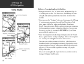
It navigates directly from downloaded detail mapping) to automatically calculate a route to your destination. The routes use roads. If there are added to the active route page and will appear to point. GPSmap 60 GPS Navigation Using Routes Direct Line Navigation Go To (Distance) Navigation from Waypoint to Waypoint Auto Routing 40 Manual Routing Navigation using...
It navigates directly from downloaded detail mapping) to automatically calculate a route to your destination. The routes use roads. If there are added to the active route page and will appear to point. GPSmap 60 GPS Navigation Using Routes Direct Line Navigation Go To (Distance) Navigation from Waypoint to Waypoint Auto Routing 40 Manual Routing Navigation using...

Owner's Manual
Page 54
... travel displayed on the highway. Your course is explained in or out on the highway graphic. 2. Press the MENU key to your final destination. GPSmap 60 GPS Navigation The Highway Page Highway Page with a destination guidance message, Change the Data Fields or restore Defaults to zoom in detail on course to... stay on page 11. As you move toward each point on your route, the graphic will show the direction you to factory settings. You can guide you to next point on the route, etc. To navigate using data fields and a graphic highway. ...
... travel displayed on the highway. Your course is explained in or out on the highway graphic. 2. Press the MENU key to your final destination. GPSmap 60 GPS Navigation The Highway Page Highway Page with a destination guidance message, Change the Data Fields or restore Defaults to zoom in detail on course to... stay on page 11. As you move toward each point on your route, the graphic will show the direction you to factory settings. You can guide you to next point on the route, etc. To navigate using data fields and a graphic highway. ...

Owner's Manual
Page 56
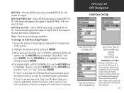
... Setup Page allows you to set the backlight timeout, the level of the beacon receiver directly from the GPSmap 60. using a USB or Serial Port Cable The following settings are available: GARMIN - The proprietary format used when connecting your unit to a computer, external NMEA devices...Out - With an option for tuning of brightness, which can significantly save battery power, and the display contrast. GARMIN DGPS - GPSmap 60 GPS Navigation Display Setup Backlight Timeout Options Display Setup Page Interface Setup Brightness and Contrast Level Selector Data Format Interface Setup...
... Setup Page allows you to set the backlight timeout, the level of the beacon receiver directly from the GPSmap 60. using a USB or Serial Port Cable The following settings are available: GARMIN - The proprietary format used when connecting your unit to a computer, external NMEA devices...Out - With an option for tuning of brightness, which can significantly save battery power, and the display contrast. GARMIN DGPS - GPSmap 60 GPS Navigation Display Setup Backlight Timeout Options Display Setup Page Interface Setup Brightness and Contrast Level Selector Data Format Interface Setup...
Owner's Manual
Page 57
... IMPORTANT NOTE: When the USB cable is connected to the GPS map 60, it is selected, the GPSMap 60 will appear. Allows DGPS input using a standard RTCM SC-104 format and supports the output of simple ASCII text output of this section. 2. For Garmin DGPS or RTCM In/NMEA Out, use the ROCKER key to... appropriate settings. No output. Highlight the desired setting and press ENTER. 3. When you select Text Out and /or RTCM In, additional fields will automatically direct the beacon receiver to beacon are displayed in Garmin Format.
... IMPORTANT NOTE: When the USB cable is connected to the GPS map 60, it is selected, the GPSMap 60 will appear. Allows DGPS input using a standard RTCM SC-104 format and supports the output of simple ASCII text output of this section. 2. For Garmin DGPS or RTCM In/NMEA Out, use the ROCKER key to... appropriate settings. No output. Highlight the desired setting and press ENTER. 3. When you select Text Out and /or RTCM In, additional fields will automatically direct the beacon receiver to beacon are displayed in Garmin Format.

Owner's Manual
Page 63
... you to the Garmin website (www.garmin.com), for details and directions for maritime navigation. Access the Marine Setup Page. 2. Highlight the symbols fields and press ENTER to find and record items hidden at geographic locations. To use the Number Keypad to activate the desired alarm and press ENTER. 3. GPSmap 60 GPS Navigation Geocache...
... you to the Garmin website (www.garmin.com), for details and directions for maritime navigation. Access the Marine Setup Page. 2. Highlight the symbols fields and press ENTER to find and record items hidden at geographic locations. To use the Number Keypad to activate the desired alarm and press ENTER. 3. GPSmap 60 GPS Navigation Geocache...

Owner's Manual
Page 80
...desired path of your destination point. ETA - Elevation - Accuracy GPS - The current accuracy of travel from your GPSmap 60. Course - ETA - Some of a route. The compass direction from your starting point to your GPS determined location. Depth - Distance - The distance to end, of these ... current speed and course. The ratio of each data field option. Distance - Next - Destination - Glide Ratio - GPSmap 60 Appendices Data Field Options 70 The following list provides a brief description of horizontal distance traveled to a destination point.
...desired path of your destination point. ETA - Elevation - Accuracy GPS - The current accuracy of travel from your GPSmap 60. Course - ETA - Some of a route. The compass direction from your starting point to your GPS determined location. Depth - Distance - The distance to end, of these ... current speed and course. The ratio of each data field option. Distance - Next - Destination - Glide Ratio - GPSmap 60 Appendices Data Field Options 70 The following list provides a brief description of horizontal distance traveled to a destination point.

Owner's Manual
Page 81
...required to the next point on a route. Heading - Your current location as indicated by both the moving . Odometer - Speed - GPSmap 60 Appendices Data Field Options 71 The arrow that indicates the direction to the destination's elevation. Your current vehicle speed can be measured in degrees or cardinal letters (N,S,E,W). The average speed while... speed. Overall Avg. - The average speed determined by a compass, in miles per hour, kilometers per hour or knots. Location (selected) - Moving Avg. - Your direction of measure (other than lat/lon). The distance off your...
...required to the next point on a route. Heading - Your current location as indicated by both the moving . Odometer - Speed - GPSmap 60 Appendices Data Field Options 71 The arrow that indicates the direction to the destination's elevation. Your current vehicle speed can be measured in degrees or cardinal letters (N,S,E,W). The average speed while... speed. Overall Avg. - The average speed determined by a compass, in miles per hour, kilometers per hour or knots. Location (selected) - Moving Avg. - Your direction of measure (other than lat/lon). The distance off your...

Owner's Manual
Page 82
...while the unit was reset. The length of distance traveled since the Trip Computer was reset). The current time and date. Trip Time - Total - GPSmap 60 Appendices Data Field Options 72 Sunrise - Trip Odometer - Sunset - Time To Next - The time of time your current speed and course. The ... on your route, if you maintain your location (since the Trip Computer was powered On and tracking your current speed and course. Your direction of , and distance to get back on an active route. The length of sunset for the current date and location. Turn - Time...
...while the unit was reset. The length of distance traveled since the Trip Computer was reset). The current time and date. Trip Time - Total - GPSmap 60 Appendices Data Field Options 72 Sunrise - Trip Odometer - Sunset - Time To Next - The time of time your current speed and course. The ... on your route, if you maintain your location (since the Trip Computer was powered On and tracking your current speed and course. Your direction of , and distance to get back on an active route. The length of sunset for the current date and location. Turn - Time...
Owner's Manual
Page 93
... and this distributor provides local service for your unit. The Garmin GPSMAP 60 has no user-serviceable parts. Should you ever encounter a problem with your Garmin product: http://www.garmin.com/products/gpsmap60/. Garmin will not replace missing components from any package purchased through online... GPSMAP 60 product is provided by international distributors for your unit, please take it to the Garmin service center in the United Kingdom, the United States, Canada, or Taiwan for rebates or other relevant provisions of Directive 1999/5/EC. Declaration of Conformity Hereby, Garmin...
... and this distributor provides local service for your unit. The Garmin GPSMAP 60 has no user-serviceable parts. Should you ever encounter a problem with your Garmin product: http://www.garmin.com/products/gpsmap60/. Garmin will not replace missing components from any package purchased through online... GPSMAP 60 product is provided by international distributors for your unit, please take it to the Garmin service center in the United Kingdom, the United States, Canada, or Taiwan for rebates or other relevant provisions of Directive 1999/5/EC. Declaration of Conformity Hereby, Garmin...


