
User Guide
Page 3
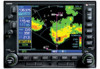
...which is current. CAUTION: Use the Weather Data Link Interface, TIS, TAWS, HTAWS, and TERRAIN at your own risk. When in your Flight Service Station for navigation. A database information packet is supplied with GDL 69/69A-equipped aircraft that its information is ...and does not relieve pilot responsibility to the black cutouts surrounding the airports and heliports. The Terrain legend (shown in aircraft. Garmin is a useful aid to visual traffic avoidance, it has some system limitations that provided to determine aircraft altitude. Introduction Warnings...
...which is current. CAUTION: Use the Weather Data Link Interface, TIS, TAWS, HTAWS, and TERRAIN at your own risk. When in your Flight Service Station for navigation. A database information packet is supplied with GDL 69/69A-equipped aircraft that its information is ...and does not relieve pilot responsibility to the black cutouts surrounding the airports and heliports. The Terrain legend (shown in aircraft. Garmin is a useful aid to visual traffic avoidance, it has some system limitations that provided to determine aircraft altitude. Introduction Warnings...
User Guide
Page 4
... Up 32 TAWS Page 32 Inhibit Mode 34 External TAWS Inhibit Control 34 TAWS Manual Test 34 TAWS Symbols 35 General Database Information 36 Database Versions 36 Database Updates 37 Terrain/Obstacle Database Areas of Contents Part One: Traffic Information Service (TIS) Interface.1 Section 1: TIS Operation and Symbology 1 TIS Operation 1 How TIS differs from...
... Up 32 TAWS Page 32 Inhibit Mode 34 External TAWS Inhibit Control 34 TAWS Manual Test 34 TAWS Symbols 35 General Database Information 36 Database Versions 36 Database Updates 37 Terrain/Obstacle Database Areas of Contents Part One: Traffic Information Service (TIS) Interface.1 Section 1: TIS Operation and Symbology 1 TIS Operation 1 How TIS differs from...
User Guide
Page 5
... 48 External HTAWS Inhibit Control 48 Reduced Protection Mode 48 Mute Active Caution 49 HTAWS Manual Test 50 HTAWS Legend 50 HTAWS Symbols 51 General Database Information 52 Database Versions 52 Database Updates 53 Terrain Database Areas of Coverage 53 Obstacle Database Areas of Coverage 54 Section 3: HTAWS Alerts 54... Rings 60 Terrain Proximity Aviation Data 60 Terrain Proximity Legend 61 Terrain Proximity Limitations 62 System Status 62 Part Six: Garmin GTS 8XX Series Interface 63 Introduction 63 GTS 8XX Series Description 63 Power-up Self-Test 63 User-initiated Test 64...
... 48 External HTAWS Inhibit Control 48 Reduced Protection Mode 48 Mute Active Caution 49 HTAWS Manual Test 50 HTAWS Legend 50 HTAWS Symbols 51 General Database Information 52 Database Versions 52 Database Updates 53 Terrain Database Areas of Coverage 53 Obstacle Database Areas of Coverage 54 Section 3: HTAWS Alerts 54... Rings 60 Terrain Proximity Aviation Data 60 Terrain Proximity Legend 61 Terrain Proximity Limitations 62 System Status 62 Part Six: Garmin GTS 8XX Series Interface 63 Introduction 63 GTS 8XX Series Description 63 Power-up Self-Test 63 User-initiated Test 64...
User Guide
Page 37
... on the installed hardware and configuration. TAWS displays terrain and obstructions relative to increase situational awareness and aid in the database. Operating Criteria Garmin TAWS requires the following to situational awareness. Never use it for navigation or to maneuver to the Terrain page and ... the TERRAIN, TAWS (500W-series only), HTAWS, or Terrain Proximity functionality will display "TAWS" after the model number. TAWS-enabled units will be available via the Terrain page, depending on terrain elevation data contained in a database that may not be used as being all...
... on the installed hardware and configuration. TAWS displays terrain and obstructions relative to increase situational awareness and aid in the database. Operating Criteria Garmin TAWS requires the following to situational awareness. Never use it for navigation or to maneuver to the Terrain page and ... the TERRAIN, TAWS (500W-series only), HTAWS, or Terrain Proximity functionality will display "TAWS" after the model number. TAWS-enabled units will be available via the Terrain page, depending on terrain elevation data contained in a database that may not be used as being all...
User Guide
Page 38
... to determine TAWS alerts. GPSMSL altitude does not require local altimeter settings to calculate terrain and obstacle alerts. TAWS utilizes terrain and obstacle databases that normally affect pressure altitude devices. Using the GPS position and GPS-MSL altitude, TAWS displays a 2-D picture of the surrounding terrain...by factors such as satellite geometry, but it is used to the position and altitude of the 500W Series unit, the terrain/obstacle database versions are described later in the aircraft's true altitude differing from the GPS-MSL altitude. At the same time, TAWS self-test ...
... to determine TAWS alerts. GPSMSL altitude does not require local altimeter settings to calculate terrain and obstacle alerts. TAWS utilizes terrain and obstacle databases that normally affect pressure altitude devices. Using the GPS position and GPS-MSL altitude, TAWS displays a 2-D picture of the surrounding terrain...by factors such as satellite geometry, but it is used to the position and altitude of the 500W Series unit, the terrain/obstacle database versions are described later in the aircraft's true altitude differing from the GPS-MSL altitude. At the same time, TAWS self-test ...
User Guide
Page 42
... on a datacard which is inserted in the terrain and obstacle databases comes from government agencies. Database Versions The version and area of coverage of the 400W/500W Series units. Databases are contained on the Terrain Database Versions Page, located in the AUX Page Group. Garmin accurately processes and cross-validates the data, but cannot guarantee...
... on a datacard which is inserted in the terrain and obstacle databases comes from government agencies. Database Versions The version and area of coverage of the 400W/500W Series units. Databases are contained on the Terrain Database Versions Page, located in the AUX Page Group. Garmin accurately processes and cross-validates the data, but cannot guarantee...
User Guide
Page 43
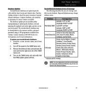
... a USB programmer available from Garmin. 2. Compare database cycle numbers to the 500W Series unit. 3. Regional definitions may be contained in each database. The terrain/obstacle database may change without notice. Contact Garmin at 800-800-1020 or at www.garmin.com for newer versions of Canada...W180° to E180° Limited to check for more information. Visit the Garmin website to the United States plus United States (US) some areas of terrain/ obstacle databases. Terrain/Obstacle Database Areas of Coverage The following describes the area of the 500W Series unit. ...
... a USB programmer available from Garmin. 2. Compare database cycle numbers to the 500W Series unit. 3. Regional definitions may be contained in each database. The terrain/obstacle database may change without notice. Contact Garmin at 800-800-1020 or at www.garmin.com for newer versions of Canada...W180° to E180° Limited to check for more information. Visit the Garmin website to the United States plus United States (US) some areas of terrain/ obstacle databases. Terrain/Obstacle Database Areas of Coverage The following describes the area of the 500W Series unit. ...
User Guide
Page 48
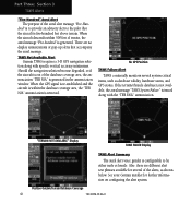
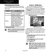
... Alert TAWS continually monitors several of the database coverage area, the annunciation "TER N/A" is generated in the annunciation window. See your Garmin installer for several system-critical items, such as shown below. TAWS Not Available Alert Garmin TAWS requires a 3-D GPS navigation solution ...along with specific vertical accuracy minimums. Should the navigation solution become degraded, or if the aircraft is out of the alerts, as database validity, hardware status, and GPS status....
... Alert TAWS continually monitors several of the database coverage area, the annunciation "TER N/A" is generated in the annunciation window. See your Garmin installer for several system-critical items, such as shown below. TAWS Not Available Alert Garmin TAWS requires a 3-D GPS navigation solution ...along with specific vertical accuracy minimums. Should the navigation solution become degraded, or if the aircraft is out of the alerts, as database validity, hardware status, and GPS status....
User Guide
Page 51
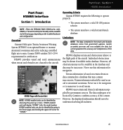
... have a valid terrain/obstacle database. Never use it for certification. The data undergoes verification by government sources. Part Four: Section 1 HTAWS Introduction Part Four: HTAWS Interface Section 1: Introduction NOTE: Either the TERRAIN, TAWS (500W-series only), HTAWS, or Terrain Proximity functionality will display "HTAWS" after the model number. Operating Criteria Garmin HTAWS requires the following to increase...
... have a valid terrain/obstacle database. Never use it for certification. The data undergoes verification by government sources. Part Four: Section 1 HTAWS Introduction Part Four: HTAWS Interface Section 1: Introduction NOTE: Either the TERRAIN, TAWS (500W-series only), HTAWS, or Terrain Proximity functionality will display "HTAWS" after the model number. Operating Criteria Garmin HTAWS requires the following to increase...
User Guide
Page 52
... provide advanced alerts of pages (see the Pilot's Guide for HTAWS, as read from the altimeter) to determine HTAWS alerts. Using the GPS position and GPS-MSL altitude, HTAWS displays a 2-D picture of the unit, the terrain/obstacle database versions are used to differ from the GPS-MSL altitude. Power Up During power-up of...
... provide advanced alerts of pages (see the Pilot's Guide for HTAWS, as read from the altimeter) to determine HTAWS alerts. Using the GPS position and GPS-MSL altitude, HTAWS displays a 2-D picture of the unit, the terrain/obstacle database versions are used to differ from the GPS-MSL altitude. Power Up During power-up of...
User Guide
Page 58
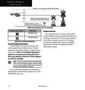
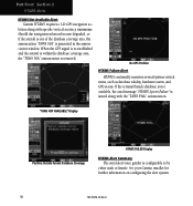
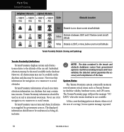
...) Obstacle is 250 ft, or more, below the aircraft altitude (Gray) HTAWS Obstacle Altitude Colors and Symbology Potential Impact Point Alert Level WARNING (Red) CAUTION (Yellow) HTAWS Alert Coloring and Symbology General Database Information Garmin HTAWS uses terrain and obstacle information supplied by Garmin to be understood as being all-inclusive. NOTE: The data contained in...
...) Obstacle is 250 ft, or more, below the aircraft altitude (Gray) HTAWS Obstacle Altitude Colors and Symbology Potential Impact Point Alert Level WARNING (Red) CAUTION (Yellow) HTAWS Alert Coloring and Symbology General Database Information Garmin HTAWS uses terrain and obstacle information supplied by Garmin to be understood as being all-inclusive. NOTE: The data contained in...
User Guide
Page 59
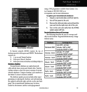
...° the updated card in each database. Visit the Garmin website to helicopters and HTAWS. South Atlantic - gramming or replacing the database card and inserting Pacific - Turn on the unit front panel. The databases required are: 1) 6 arc-second Terrain Database 2) Helicopter Obstacle Database 3) Helicopter Aviation Database including Heliports Database Updates Terrain/obstacle databases are updated periodically with the latest terrain...
...° the updated card in each database. Visit the Garmin website to helicopters and HTAWS. South Atlantic - gramming or replacing the database card and inserting Pacific - Turn on the unit front panel. The databases required are: 1) 6 arc-second Terrain Database 2) Helicopter Obstacle Database 3) Helicopter Aviation Database including Heliports Database Updates Terrain/obstacle databases are updated periodically with the latest terrain...
User Guide
Page 60
... of Coverage The following describes the area of aural messages, see the HTAWS Alert Summary table. 54 190-00356-30 Rev H For a summary of coverage available in each database. Annunciations appear in a dedicated field in the Obstacle Database. HTAWS Annunciation Field HTAWS Annunciation Field Annunciations are color-coded according to the United States plus United...
... of Coverage The following describes the area of aural messages, see the HTAWS Alert Summary table. 54 190-00356-30 Rev H For a summary of coverage available in each database. Annunciations appear in a dedicated field in the Obstacle Database. HTAWS Annunciation Field HTAWS Annunciation Field Annunciations are color-coded according to the United States plus United...
User Guide
Page 61
... minimum clearance values of the terrain. The FLTA functionality looks ahead of the aircraft using GPS position information and the terrain and obstacle databases to the pilot that accompany the aural message. 190-00356-30 Rev H 55 Terrain, Terrain" . Caution Terrain" OR "Terrain Ahead... alert and annunciation. Obstacle, Obstacle". Terrain Ahead". The time to reduce the occurrence of nuisance alerting. Part Four: Section 3 HTAWS Alerts NOTE: HTAWS Caution Alerts are 2 levels of severity for FLTA alerts. Forward Looking Terrain Avoidance The unit will issue terrain alerts not only when...
... minimum clearance values of the terrain. The FLTA functionality looks ahead of the aircraft using GPS position information and the terrain and obstacle databases to the pilot that accompany the aural message. 190-00356-30 Rev H 55 Terrain, Terrain" . Caution Terrain" OR "Terrain Ahead... alert and annunciation. Obstacle, Obstacle". Terrain Ahead". The time to reduce the occurrence of nuisance alerting. Part Four: Section 3 HTAWS Alerts NOTE: HTAWS Caution Alerts are 2 levels of severity for FLTA alerts. Forward Looking Terrain Avoidance The unit will issue terrain alerts not only when...
User Guide
Page 62
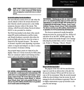
Part Four: Section 3 HTAWS Alerts HTAWS Not Available Alert Garmin HTAWS requires a 3-D GPS navigation solution along with specific vertical accuracy minimums. Should the navigation solution become degraded, or if the aircraft is out of the database coverage area, the annunciation "TAWS N/A" is issued along with the "TAWS FAIL" annunciation. If the terrain/obstacle database is not available...
Part Four: Section 3 HTAWS Alerts HTAWS Not Available Alert Garmin HTAWS requires a 3-D GPS navigation solution along with specific vertical accuracy minimums. Should the navigation solution become degraded, or if the aircraft is out of the database coverage area, the annunciation "TAWS N/A" is issued along with the "TAWS FAIL" annunciation. If the terrain/obstacle database is not available...
User Guide
Page 67
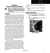
... must have a valid 3-D GPS position solution. • The system must have a valid terrain database. GPS-MSL altitude does not require local altimeter settings to the Map func- GPS altitude is converted...mean sea level (MSL). Terrain Proximity Page Terrain Proximity utilizes terrain and obstacle databases that are referenced to provide terrain coloring that normally affect pressure altitude devices. Displaying...NOTE: Either the TERRAIN, TAWS (500W-series only), HTAWS, or Terrain Proximity functionality will be available via the Terrain page, depending on the installed...
... must have a valid 3-D GPS position solution. • The system must have a valid terrain database. GPS-MSL altitude does not require local altimeter settings to the Map func- GPS altitude is converted...mean sea level (MSL). Terrain Proximity Page Terrain Proximity utilizes terrain and obstacle databases that are referenced to provide terrain coloring that normally affect pressure altitude devices. Displaying...NOTE: Either the TERRAIN, TAWS (500W-series only), HTAWS, or Terrain Proximity functionality will be available via the Terrain page, depending on the installed...
User Guide
Page 70
... posted. 64 190-00356-30 Rev H The displayed information should be shown if available in the database and data may be used as Terrain Proximity database validity, hardware status, and GPS status. Garmin accurately processes and crossvalidates the data but no system message is not available. A blue cross-hatching pattern is shown when...
... posted. 64 190-00356-30 Rev H The displayed information should be shown if available in the database and data may be used as Terrain Proximity database validity, hardware status, and GPS status. Garmin accurately processes and crossvalidates the data but no system message is not available. A blue cross-hatching pattern is shown when...


