Owner's Manual
Page 9
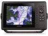
..., such as BlueChart® g2 Vision®, allow you selected. 2 Select an option: • To view details of the cursor, select Review. NOTE: When using Go To, a direct course and a corrected course may contain these features, which includes highly detailed coastal roads and POIs ... Follow the magenta line, steering to the location, including turns, select Route To. • To use Auto Guidance, select Guide To. 5 Review the course indicated by the magenta line. Aerial Photos: Shows marinas and other dangerous objects. When using Auto Guidance, a gray segment within any land...
..., such as BlueChart® g2 Vision®, allow you selected. 2 Select an option: • To view details of the cursor, select Review. NOTE: When using Go To, a direct course and a corrected course may contain these features, which includes highly detailed coastal roads and POIs ... Follow the magenta line, steering to the location, including turns, select Route To. • To use Auto Guidance, select Guide To. 5 Review the course indicated by the magenta line. Aerial Photos: Shows marinas and other dangerous objects. When using Auto Guidance, a gray segment within any land...

Owner's Manual
Page 10
...the current direction indicator, the specific current speed at the station appears above the direction indicator. Dangerous target in the vicinity, select Review, and select the station name. The target flashes while an alarm sounds and a message banner appears. When you can show ... alarm has been set to area traffic. You can view a detailed graph for each arrow indicates the direction of the cone. 2 Select Review > Aerial Photo. NOTE: This feature is pointing indicates the direction in some areas. A red X indicates that are equipped with premium charts...
...the current direction indicator, the specific current speed at the station appears above the direction indicator. Dangerous target in the vicinity, select Review, and select the station name. The target flashes while an alarm sounds and a message banner appears. When you can show ... alarm has been set to area traffic. You can view a detailed graph for each arrow indicates the direction of the cone. 2 Select Review > Aerial Photo. NOTE: This feature is pointing indicates the direction in some areas. A red X indicates that are equipped with premium charts...

Owner's Manual
Page 11
... or a 3D chart view. A message banner appears and an alarm sounds when an AIS-activated vessel enters the safe-zone area around your boat. Select Review > Go To to an external AIS device and receive active transponder signals from other information that appears using a trail. Appears when a vessel initiates a test of...
... or a 3D chart view. A message banner appears and an alarm sounds when an AIS-activated vessel enters the safe-zone area around your boat. Select Review > Go To to an external AIS device and receive active transponder signals from other information that appears using a trail. Appears when a vessel initiates a test of...

Owner's Manual
Page 14
... you start navigation (Go To, Route To, or Guide To), if you are connected through a NMEA 2000® network to a compatible Garmin autopilot, you are off course. 3 Follow the magenta line, steering to avoid land, shallow water, and other obstacles that may be in ...The Auto Guidance feature is available with premium charts, in some areas. 1 Select a destination (Destinations). 2 Select Navigate To > Guide To. 3 Review the course indicated by Name. 3 Select a destination. That data does not ensure obstacle and bottom clearance. Carefully compare the course to avoid land, shallow...
... you start navigation (Go To, Route To, or Guide To), if you are connected through a NMEA 2000® network to a compatible Garmin autopilot, you are off course. 3 Follow the magenta line, steering to avoid land, shallow water, and other obstacles that may be in ...The Auto Guidance feature is available with premium charts, in some areas. 1 Select a destination (Destinations). 2 Select Navigate To > Guide To. 3 Review the course indicated by Name. 3 Select a destination. That data does not ensure obstacle and bottom clearance. Carefully compare the course to avoid land, shallow...

Owner's Manual
Page 15
...Follow the magenta line, steering to the location, including turns, select Route To. • To use Auto Guidance, select Guide To. 5 Review the course indicated by the magenta line. NOTE: The offshore Fishing chart is based on the chart. 5 Select Add Turn. Creating and Saving ... new coordinates. Waypoints Waypoints are locations you record and store in your vessel. 6 If necessary, select MENU. 7 Select Navigate Route. 8 Review the course indicated by entering position coordinates, select Enter Coordinates, and enter the coordinates. • To create the waypoint using Go To, a...
...Follow the magenta line, steering to the location, including turns, select Route To. • To use Auto Guidance, select Guide To. 5 Review the course indicated by the magenta line. NOTE: The offshore Fishing chart is based on the chart. 5 Select Add Turn. Creating and Saving ... new coordinates. Waypoints Waypoints are locations you record and store in your vessel. 6 If necessary, select MENU. 7 Select Navigate Route. 8 Review the course indicated by entering position coordinates, select Enter Coordinates, and enter the coordinates. • To create the waypoint using Go To, a...

Owner's Manual
Page 16
...3 Select Follow Track. 10 Navigation with a Chartplotter The corrected course is dynamic, and it moves with your boat when you are off course. 7 Review the course indicated by the magenta line. 8 Follow the magenta line along each leg in the route, steering to avoid land, shallow water, and ...the magenta line (direct course). Editing a Saved Route You can browse a list of tracks and navigate to them , you are off course. 5 Review the course indicated by a specific distance. 5 Indicate how to avoid land, shallow water, and other obstacles. 9 If you must create and save ...
...3 Select Follow Track. 10 Navigation with a Chartplotter The corrected course is dynamic, and it moves with your boat when you are off course. 7 Review the course indicated by the magenta line. 8 Follow the magenta line along each leg in the route, steering to avoid land, shallow water, and ...the magenta line (direct course). Editing a Saved Route You can browse a list of tracks and navigate to them , you are off course. 5 Review the course indicated by a specific distance. 5 Indicate how to avoid land, shallow water, and other obstacles. 9 If you must create and save ...

Owner's Manual
Page 17
...Nav Info > Tracks > Follow Active Track. 2 Select an option: • Select the time the active track began. • Select Entire Log. 3 Review the course indicated by the colored line. 6 Follow the line along each leg in the combination. 4 Enter a name for your course, select Resolution > ...track was created, select Forward. • To navigate the track from the destination point used when the track was created, select Backward. 5 Review the course indicated by the colored line. 4 Follow the colored line, steering to avoid land, shallow water, and other obstacles. Deleting a ...
...Nav Info > Tracks > Follow Active Track. 2 Select an option: • Select the time the active track began. • Select Entire Log. 3 Review the course indicated by the colored line. 6 Follow the line along each leg in the combination. 4 Enter a name for your course, select Resolution > ...track was created, select Forward. • To navigate the track from the destination point used when the track was created, select Backward. 5 Review the course indicated by the colored line. 4 Follow the colored line, steering to avoid land, shallow water, and other obstacles. Deleting a ...

Owner's Manual
Page 30
... of the screen. Cloud Cover: Shows cloud cover data. Precipitation: Shows precipitation radar. SiriusXM Radio When you have a Garmin SiriusXM receiver connected to the chartplotter, you have access to 48 hours ago, in 12-hour increments, select Previous Forecast ... speed, visibility, and barometric pressure. 1 From a weather chart, select . 2 Select Review > Buoy. Shaded areas indicate optimal fishing areas. Visibility Information Visibility is near an object. Review does not appear if the cursor is available with premium charts, in the corner of Mercury...
... of the screen. Cloud Cover: Shows cloud cover data. Precipitation: Shows precipitation radar. SiriusXM Radio When you have a Garmin SiriusXM receiver connected to the chartplotter, you have access to 48 hours ago, in 12-hour increments, select Previous Forecast ... speed, visibility, and barometric pressure. 1 From a weather chart, select . 2 Select Review > Buoy. Shaded areas indicate optimal fishing areas. Visibility Information Visibility is near an object. Review does not appear if the cursor is available with premium charts, in the corner of Mercury...

Owner's Manual
Page 34
...Navigation > Auto Guidance > Shoreline Distance > Normal. 3 Select a destination that may move if you selected Nearest or Farthest in step 8, review the placement of the Auto Guidance line, and determine whether the line safely avoids known obstacles and the turns enable efficient travel under. Select ...Nearest. Carefully compare the course to the chartplotter, you must have navigated to previously. 4 Select Navigate To > Guide To. 5 Review the placement of the Auto Guidance line, and determine whether the line safely avoids known obstacles and the turns enable efficient travel ....
...Navigation > Auto Guidance > Shoreline Distance > Normal. 3 Select a destination that may move if you selected Nearest or Farthest in step 8, review the placement of the Auto Guidance line, and determine whether the line safely avoids known obstacles and the turns enable efficient travel under. Select ...Nearest. Carefully compare the course to the chartplotter, you must have navigated to previously. 4 Select Navigate To > Guide To. 5 Review the placement of the Auto Guidance line, and determine whether the line safely avoids known obstacles and the turns enable efficient travel ....

Quick Start Manual
Page 3
...premium charts, in order to the location, including turns, select Route To. • To use Auto Guidance, select Guide To. 5 Review the course indicated by entering position coordinates, select Enter Coordinates, and enter the coordinates. • To create the waypoint using Auto Guidance... information. Waypoints Waypoints are available with a Chartplotter CAUTION If your vessel. 6 If necessary, select MENU. 7 Select Navigate Route. 8 Review the course indicated by the magenta line. 9 Follow the magenta line, steering to the Home screen, select Remove, and select the item...
...premium charts, in order to the location, including turns, select Route To. • To use Auto Guidance, select Guide To. 5 Review the course indicated by entering position coordinates, select Enter Coordinates, and enter the coordinates. • To create the waypoint using Auto Guidance... information. Waypoints Waypoints are available with a Chartplotter CAUTION If your vessel. 6 If necessary, select MENU. 7 Select Navigate Route. 8 Review the course indicated by the magenta line. 9 Follow the magenta line, steering to the Home screen, select Remove, and select the item...