Owner's Manual
Page 1
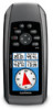
GPSMAP® 78 series owner's manual for use with the GPSMAP 78, GPSMAP 78S, and GPSMAP 78Sc
GPSMAP® 78 series owner's manual for use with the GPSMAP 78, GPSMAP 78S, and GPSMAP 78Sc
Owner's Manual
Page 18
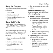
...on the device. To purchase additional maps, see page 38. Do not stand near objects that direction until the arrow is available only with the GPSMAP 78S and GPSMAP 78Sc. Calibrating the Compass notice Calibrate the electronic compass outdoors. You should calibrate the compass after moving . If it points any other direction, turn toward... or overhead power lines. Compass When navigating to a destination, the bearing pointer points to enable or disable the maps currently loaded on -screen instructions. 14 GPSMAP 78 Series Owner's Manual Select Calibrate Compass > Start. 3.
...on the device. To purchase additional maps, see page 38. Do not stand near objects that direction until the arrow is available only with the GPSMAP 78S and GPSMAP 78Sc. Calibrating the Compass notice Calibrate the electronic compass outdoors. You should calibrate the compass after moving . If it points any other direction, turn toward... or overhead power lines. Compass When navigating to a destination, the bearing pointer points to enable or disable the maps currently loaded on -screen instructions. 14 GPSMAP 78 Series Owner's Manual Select Calibrate Compass > Start. 3.
Owner's Manual
Page 19
... degrees (0°-359°). ◦◦ Mils-sets the compass reading to the object. 1. GPSMAP 78 Series Owner's Manual Using the Main Pages 4. Select Lock Direction > Set Course. Using Sight 'N Go NOTE: Sight 'N Go is available only with the GPSMAP 78S and GPSMAP 78Sc. You can use the compass to your location. 15 Compass Setup Options From the...
... degrees (0°-359°). ◦◦ Mils-sets the compass reading to the object. 1. GPSMAP 78 Series Owner's Manual Using the Main Pages 4. Select Lock Direction > Set Course. Using Sight 'N Go NOTE: Sight 'N Go is available only with the GPSMAP 78S and GPSMAP 78Sc. You can use the compass to your location. 15 Compass Setup Options From the...
Owner's Manual
Page 20
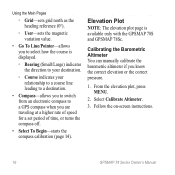
Calibrating the Barometric Altimeter You can manually calibrate the barometric altimeter if you are traveling at a higher rate of speed for a set period of time, or turns the compass off. • Select ... a GPS compass when you know the correct elevation or the correct pressure. 1. From the elevation plot, press menu. 2. Follow the on-screen instructions. 16 GPSMAP 78 Series Owner's Manual Using the Main Pages ◦◦ Grid-sets grid north as the heading reference (0°). ◦◦ User-sets the magnetic variation value. • Go...
Calibrating the Barometric Altimeter You can manually calibrate the barometric altimeter if you are traveling at a higher rate of speed for a set period of time, or turns the compass off. • Select ... a GPS compass when you know the correct elevation or the correct pressure. 1. From the elevation plot, press menu. 2. Follow the on-screen instructions. 16 GPSMAP 78 Series Owner's Manual Using the Main Pages ◦◦ Grid-sets grid north as the heading reference (0°). ◦◦ User-sets the magnetic variation value. • Go...
Owner's Manual
Page 23
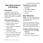
...compatible Garmin device. Select Send or Receive. 3. Main Menu Features and Settings Geocaches Geocaching is available only with the GPSMAP 78S and GPSMAP 78Sc. ...Select a geocache. 4. Register your computer (page 40). 3. Go to a Geocache 1. You must be within 10 feet (3 m) of treasure hunting, in . 5. Your device can send or receive data when connected to www.garmin.com/products /communicator. 4. From the main menu, select Share Wirelessly. 2. Go to another compatible device. Downloading Geocaches 1. GPSMAP 78 Series Owner's Manual...
...compatible Garmin device. Select Send or Receive. 3. Main Menu Features and Settings Geocaches Geocaching is available only with the GPSMAP 78S and GPSMAP 78Sc. ...Select a geocache. 4. Register your computer (page 40). 3. Go to a Geocache 1. You must be within 10 feet (3 m) of treasure hunting, in . 5. Your device can send or receive data when connected to www.garmin.com/products /communicator. 4. From the main menu, select Share Wirelessly. 2. Go to another compatible device. Downloading Geocaches 1. GPSMAP 78 Series Owner's Manual...
Owner's Manual
Page 27
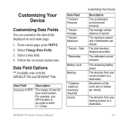
... field. 4. Data Field Options ** Available only with the GPSMAP 78S and GPSMAP 78Sc. The remaining battery power. Total **Barometer Battery Level Bearing **Cadence (cadence accessory required) Course Customizing Your Device Description The uncalibrated environmental pressure. The calibrated current pressure. The total elevation distance ascended. GPSMAP 78 Series Owner's Manual 23 Select Change Data Fields. 3. The direction from your...
... field. 4. Data Field Options ** Available only with the GPSMAP 78S and GPSMAP 78Sc. The remaining battery power. Total **Barometer Battery Level Bearing **Cadence (cadence accessory required) Course Customizing Your Device Description The uncalibrated environmental pressure. The calibrated current pressure. The total elevation distance ascended. GPSMAP 78 Series Owner's Manual 23 Select Change Data Fields. 3. The direction from your...
Owner's Manual
Page 40
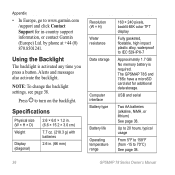
...215; 1.2 in. (6.6 × 15.2 × 3.0 cm) 7.7 oz. (218.3 g) with batteries 2.6 in -country support information, or contact Garmin (Europe) Ltd. The GPSMAP 78S and 78Sc have a microSD card slot for in . (66 mm) Resolution (W × H) Water resistance Data storage Computer interface Battery type Battery life Operating temperature ..., see page 38. Appendix • In Europe, go to www.garmin.com /support and click Contact Support for additional data storage. Alerts and messages also activate the backlight. Press to 70°C) See page 38. 36 GPSMAP 78 Series Owner's Manual
...215; 1.2 in. (6.6 × 15.2 × 3.0 cm) 7.7 oz. (218.3 g) with batteries 2.6 in -country support information, or contact Garmin (Europe) Ltd. The GPSMAP 78S and 78Sc have a microSD card slot for in . (66 mm) Resolution (W × H) Water resistance Data storage Computer interface Battery type Battery life Operating temperature ..., see page 38. Appendix • In Europe, go to www.garmin.com /support and click Contact Support for additional data storage. Alerts and messages also activate the backlight. Press to 70°C) See page 38. 36 GPSMAP 78 Series Owner's Manual
Owner's Manual
Page 43
...heart rate monitor or a cadence sensor with the GPSMAP 78S and GPSMAP 78Sc. Appendix 3. Select an option: • Select Heart Rate Monitor > On. • Select Bike Cadence Sensor > On. Tips for Pairing ANT+ Accessories with Your Garmin Device • Verify that are included with your Garmin device, move 10 m away from other ANT... by customizing your data fields (page 23). Using Optional Fitness Accessories NOTE: The Fitness option is compatible with your Garmin device. • Before you pair the first time, your Garmin device automatically GPSMAP 78 Series Owner's Manual 39
...heart rate monitor or a cadence sensor with the GPSMAP 78S and GPSMAP 78Sc. Appendix 3. Select an option: • Select Heart Rate Monitor > On. • Select Bike Cadence Sensor > On. Tips for Pairing ANT+ Accessories with Your Garmin Device • Verify that are included with your Garmin device, move 10 m away from other ANT... by customizing your data fields (page 23). Using Optional Fitness Accessories NOTE: The Fitness option is compatible with your Garmin device. • Before you pair the first time, your Garmin device automatically GPSMAP 78 Series Owner's Manual 39

Owner's Manual
Page 1
GPSMAP® 78 series owner's manual for use with the GPSMAP 78, GPSMAP 78S, and GPSMAP 78Sc
GPSMAP® 78 series owner's manual for use with the GPSMAP 78, GPSMAP 78S, and GPSMAP 78Sc

Owner's Manual
Page 18
... When navigating to a destination, the bearing pointer points to enable or disable the maps currently loaded on -screen instructions. 14 GPSMAP 78 Series Owner's Manual From the compass, press MENU. 2. note: The three-axis compass is pointing toward the top of the direction you are traveling...regardless of the compass. Do not stand near objects that direction until the arrow is available only with the GPSMAP 78S and GPSMAP 78Sc. Calibrating the Compass notice Calibrate the electronic compass outdoors. Select Calibrate Compass > Start. 3. To purchase additional maps, see page 38...
... When navigating to a destination, the bearing pointer points to enable or disable the maps currently loaded on -screen instructions. 14 GPSMAP 78 Series Owner's Manual From the compass, press MENU. 2. note: The three-axis compass is pointing toward the top of the direction you are traveling...regardless of the compass. Do not stand near objects that direction until the arrow is available only with the GPSMAP 78S and GPSMAP 78Sc. Calibrating the Compass notice Calibrate the electronic compass outdoors. Select Calibrate Compass > Start. 3. To purchase additional maps, see page 38...

Owner's Manual
Page 19
... in the distance, such as the heading reference. ◦ Magnetic-automatically sets the magnetic declination for your destination. Follow the bearing pointer to the object. GPSMAP 78 Series Owner's Manual 15 Using the Compass You can point the device at an object. 3. From the main menu, select Sight 'N Go. 2. Use the compass to navigate...
... in the distance, such as the heading reference. ◦ Magnetic-automatically sets the magnetic declination for your destination. Follow the bearing pointer to the object. GPSMAP 78 Series Owner's Manual 15 Using the Compass You can point the device at an object. 3. From the main menu, select Sight 'N Go. 2. Use the compass to navigate...

Owner's Manual
Page 20
... switch from an electronic compass to select how the course is available only with the GPSMAP 78S and GPSMAP 78Sc. Calibrating the Barometric Altimeter You can manually calibrate the barometric altimeter if you are traveling at a higher rate of speed for... a set period of time, or turns the compass off. • Select To Begin-starts the compass calibration (page 14). Follow the on-screen instructions. 16 GPSMAP 78 Series Owner's Manual...
... switch from an electronic compass to select how the course is available only with the GPSMAP 78S and GPSMAP 78Sc. Calibrating the Barometric Altimeter You can manually calibrate the barometric altimeter if you are traveling at a higher rate of speed for... a set period of time, or turns the compass off. • Select To Begin-starts the compass calibration (page 14). Follow the on-screen instructions. 16 GPSMAP 78 Series Owner's Manual...

Owner's Manual
Page 23
...Internet by those hiding the geocache. Your device can send or receive data when connected to www.garmin.com/geocache. 6. Follow the on -screen instructions to download geocaches to your device. Downloading ...Garmin device. Select Send or Receive. 3. GPSMAP 78 Series Owner's Manual 19 Go to another compatible device. Select Go. Main Menu Features and Settings Navigating to www.garmin.com/products /communicator. 4. Go to a Geocache 1. Sending and Receiving Data 1. Main Menu Features and Settings Geocaches Geocaching is available only with the GPSMAP 78S and GPSMAP 78Sc...
...Internet by those hiding the geocache. Your device can send or receive data when connected to www.garmin.com/geocache. 6. Follow the on -screen instructions to download geocaches to your device. Downloading ...Garmin device. Select Send or Receive. 3. GPSMAP 78 Series Owner's Manual 19 Go to another compatible device. Select Go. Main Menu Features and Settings Navigating to www.garmin.com/products /communicator. 4. Go to a Geocache 1. Sending and Receiving Data 1. Main Menu Features and Settings Geocaches Geocaching is available only with the GPSMAP 78S and GPSMAP 78Sc...

Owner's Manual
Page 27
... a destination. Data Field Options ** Available only with the GPSMAP 78S and GPSMAP 78Sc. Revolutions of ascent. Select Change Data Fields. 3. For example, your starting location to a destination. The calibrated current pressure. The direction from your exact location. The total elevation distance ascended. The remaining battery power. GPSMAP 78 Series Owner's Manual 23 From a main page, press meNu. 2. Follow...
... a destination. Data Field Options ** Available only with the GPSMAP 78S and GPSMAP 78Sc. Revolutions of ascent. Select Change Data Fields. 3. For example, your starting location to a destination. The calibrated current pressure. The direction from your exact location. The total elevation distance ascended. The remaining battery power. GPSMAP 78 Series Owner's Manual 23 From a main page, press meNu. 2. Follow...

Owner's Manual
Page 40
...(6.6 × 15.2 × 3.0 cm) 7.7 oz. (218.3 g) with batteries 2.6 in -country support information, or contact Garmin (Europe) Ltd. Alerts and messages also activate the backlight. The GPSMAP 78S and 78Sc have a microSD card slot for in . (66 mm) Resolution (W × H) Water resistance Data storage Computer interface Battery type Battery... See page 38. NOTE: To change the backlight settings, see page 37. Press to 70°C) See page 38. 36 GPSMAP 78 Series Owner's Manual Up to 20 hours, typical usage From 5°F to 158°F (from -15 to turn on the backlight. Appendix ...
...(6.6 × 15.2 × 3.0 cm) 7.7 oz. (218.3 g) with batteries 2.6 in -country support information, or contact Garmin (Europe) Ltd. Alerts and messages also activate the backlight. The GPSMAP 78S and 78Sc have a microSD card slot for in . (66 mm) Resolution (W × H) Water resistance Data storage Computer interface Battery type Battery... See page 38. NOTE: To change the backlight settings, see page 37. Press to 70°C) See page 38. 36 GPSMAP 78 Series Owner's Manual Up to 20 hours, typical usage From 5°F to 158°F (from -15 to turn on the backlight. Appendix ...

Owner's Manual
Page 41
...GPS is available only with the GPSMAP 78S and GPSMAP 78Sc. Adjusting the Backlight Timeout From the main menu, select Setup > Display > Backlight Timeout. The three-axis compass is subject to accuracy degradation to 100 m 2DRMS under the U.S. GPSMAP 78 Series Owner's Manual 37 Radio frequency/ protocol GPS ...prolong battery life. Quickly press to 5 m) 95% typical (WAAS accuracy in North America) The barometric altimeter is available only with the GPSMAP 78S and GPSMAP 78Sc. From the main menu, select Setup > Display > Battery Save > On. From 10 to 16 ft. (from 3 to open...
...GPS is available only with the GPSMAP 78S and GPSMAP 78Sc. Adjusting the Backlight Timeout From the main menu, select Setup > Display > Backlight Timeout. The three-axis compass is subject to accuracy degradation to 100 m 2DRMS under the U.S. GPSMAP 78 Series Owner's Manual 37 Radio frequency/ protocol GPS ...prolong battery life. Quickly press to 5 m) 95% typical (WAAS accuracy in North America) The barometric altimeter is available only with the GPSMAP 78S and GPSMAP 78Sc. From the main menu, select Setup > Display > Battery Save > On. From 10 to 16 ft. (from 3 to open...

Owner's Manual
Page 43
... range (3 m) of the ANT+ accessory. • After you pair the first time, your Garmin device automatically GPSMAP 78 Series Owner's Manual 39 Before you must install the accessory according to the device. 1. You can use ANT+™ wireless technology to send data to the instructions that the ANT+ accessory is available only with the GPSMAP 78S and GPSMAP 78Sc.
... range (3 m) of the ANT+ accessory. • After you pair the first time, your Garmin device automatically GPSMAP 78 Series Owner's Manual 39 Before you must install the accessory according to the device. 1. You can use ANT+™ wireless technology to send data to the instructions that the ANT+ accessory is available only with the GPSMAP 78S and GPSMAP 78Sc.


