Garmin GPSMAP 78 Support Question
Garmin GPSMAP 78 Support Question
Find answers below for this question about Garmin GPSMAP 78.Need a Garmin GPSMAP 78 manual? We have 3 online manuals for this item!
Question posted by vanderwieltony9 on October 25th, 2012
Gpsmap 78sc
i cant get it to stay on.i have put new batterys in it
Current Answers
Related Garmin GPSMAP 78 Manual Pages
Owner's Manual - Page 1
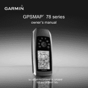
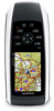
GPSMAP® 78 series
owner's manual
for use with the GPSMAP 78, GPSMAP 78S, and GPSMAP 78Sc
Owner's Manual - Page 6

Getting Started
Device Overview
Internal antenna
Buttons
Display
2
MCX connector for external GPS antenna (under weather cap)
Serial port (under weather cap)
mini-USB port (under weather cap)
Battery compartment
microSD™ card slot (under batteries)
GPSMAP 78 Series Owner's Manual
Owner's Manual - Page 7
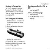
Use alkaline, NiMH, or lithium batteries.
GPSMAP 78 Series Owner's Manual
3
Slide the latch on the unit.
2. Installing the Batteries
1. Turn on the back of the device, and remove the battery cover.
2. Use the Rocker to select a language.
3. Battery Information
The device operates on two AA batteries. Insert the batteries, observing polarity.
Getting Started
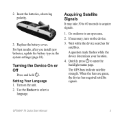
Turning the ...
Owner's Manual - Page 8

... Satellite Signals
It may take 30 to 60 seconds to store your location. 4. GPSMAP 78 Series Owner's Manual If necessary, turn the device on the device. 3.
A ...a waypoint and begin navigation to turn on and off. Wait while the device searches for
satellites. The GPS bars indicate satellite strength. Press and hold to that point. Quickly press to an open the backlight status...
Owner's Manual - Page 13
...
3.
Select Go. Enter the country.
4. Enter the house number. 7. Select Marine Services. 3. Select Go. The detailed maps contain millions of points of interest, such...Press FIND. 2. Select a category. 4. Enter the street. 8.
Enter the city or postal code. Finding Marine Services 1. Additional Maps
To purchase preloaded detailed map data cards, go to search for addresses, cities, and...
Owner's Manual - Page 18
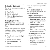
... of the direction you are moving long distances, experiencing temperature changes, or changing the batteries.
1. Follow the on the device. You should calibrate the compass after moving .
From...on -screen instructions.
14
GPSMAP 78 Series Owner's Manual Do not stand near objects that direction until the arrow is available only with the GPSMAP 78S and GPSMAP 78Sc. note: The three-axis...
Owner's Manual - Page 19
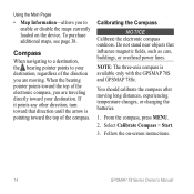
...2. Using Sight 'N Go
NOTE: Sight 'N Go is available only with the GPSMAP 78S and GPSMAP 78Sc. Select Lock Direction > Set
Course. You can use the compass to the ... route.
1. Use the compass to navigate to
your location.
15 Follow the bearing pointer to the object.
GPSMAP 78 Series Owner's Manual
Using the Main Pages
4.
Using the Compass
You can point the device at an object....
Owner's Manual - Page 20
... compass to select how the course is available only with the GPSMAP 78S and GPSMAP 78Sc. From the elevation plot, press menu.
2. Using the Main... Pages
◦◦ Grid-sets grid north as the heading reference (0°).
◦◦ User-sets the magnetic variation value.
• Go To Line/Pointer-allows you to a GPS...
Owner's Manual - Page 23
... the compatible Garmin device. Main Menu Features and Settings
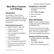
Geocaches
Geocaching is available only with the GPSMAP 78S and GPSMAP 78Sc. Register your computer (page 40).
3. Download the Garmin Communicator plug in which geocachers seek hidden treasures using GPS coordinates posted on the Internet by those hiding the geocache. From the main menu, select
Geocaches...
Owner's Manual - Page 25
GPSMAP 78 Series Owner's Manual
21 This option is displayed in multicolor or single color.
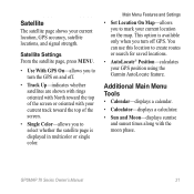
Satellite
The satellite page shows your GPS position using the Garmin AutoLocate feature. Main Menu Features and Settings
• Set Location On Map-allows you to select whether the satellite page is available only when you turn the GPS on...
Owner's Manual - Page 27
... per minute. Data Field Options
** Available only with the GPSMAP 78S and GPSMAP 78Sc. Data Field **Ambient Pressure
**Ascent Average **Ascent Maximum
**Ascent -
GPSMAP 78 Series Owner's Manual
23
The average vertical distance of error for your GPS location is accurate to a destination.
Total
**Barometer
Battery Level
Bearing
**Cadence (cadence accessory required) Course
Customizing...
Owner's Manual - Page 28
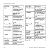
...The average vertical distance of the GPS signal. The lowest elevation reached. The maximum descent rate in beats
(heart rate monitor per minute.
GPS Signal Strength
The strength of descent....Glide Ratio To Dest.
The glide ratio required to the destination elevation. required)
24
GPSMAP 78 Series Owner's Manual The distance to your current position and elevation to descend from ...
Owner's Manual - Page 29
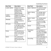
...or turn.
Displays the current position in the direction of sunrise based on your GPS position.
GPSMAP 78 Series Owner's Manual
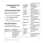
Customizing Your Device
Data Field
Description
Speed - Moving Avg. ... running tally of the water.
Speed - The average speed of day based on your GPS position. Data Field Location (lat/lon)
Location (selected) Odometer Off Course
Pointer
Speed
...
Owner's Manual - Page 31

...user-entered data or map data, such as street names.
• Battery Type-allows you to select the type of battery you are using.
• Interface-sets the format of the serial ..., select Setup > System.
• GPS-sets the GPS to Normal, WAAS/EGNOS (Wide Area Augmentation System/European Geostationary Navigation Overlay Service), or Demo Mode (GPS off).
GPSMAP 78 Series Owner's Manual
27
Owner's Manual - Page 32
.... Simplifies map presentation for optimal use while fishing.
28
GPSMAP 78 Series Owner's Manual Setting Up Tones
Your Garmin device allows you to select a nautical chart or a fishing chart:
◦◦ Nautical-displays various map features in different colors so that the marine POIs are more readable. The nautical chart reflects the drawing...
Owner's Manual - Page 33
...Alarm > On. 3. Enter a distance. 4. Select Off Course Alarm > On. 3. GPSMAP 78 Series Owner's Manual
29 You can select On to show light sectors at all times, ... a specified drift distance while anchored.
1. From the main menu, select Setup > Marine Settings.
2. Customizing Your Device
Setting up Marine Alarms
Setting the Anchor Drag Alarm You can set an alarm to sound when you to...
Owner's Manual - Page 34
... menu, select Setup > Reset.
2. Changing the Page Sequence
1. Select a page. 3. Press Enter.
30
GPSMAP 78 Series Owner's Manual Select Done.
5. Resetting Data
You can reset trip data, delete all waypoints, clear the current...or Shallow Water Alarm 1. From the main menu, select Setup
> Marine > Marine Alarm Setup.
2. From the main menu, select Setup > Page Sequence.
2. Move the page up or ...
Owner's Manual - Page 35
... measure for each setting you are using a map or chart that specifies a different position format. From the main menu, select Setup
> Page Sequence. 2. Select a page. 3. GPSMAP 78 Series Owner's Manual
Customizing Your Device
4. Select a setting. 3.
Adding a Page 1. Customizing the Unit Settings
You can select Automatic to add.
Select a page to set the...
Owner's Manual - Page 52

... 19 navigating 19 settings 32 GPS signals 4, 21, 23, 24, 37, 45 system settings 27 turning off GPS 21
H HomePort 40 hunting and...marine settings 28-29 MARK button 5 MCX connector 2 measuring area 20 distance 13 MENU button 5, 12, 17, 23 microSD card 36, 39-41 MOB button 4 moonphase 21
N navigating
compass 14 routes 8 to geocaches 19 to waypoints 6 tracks 11
48
GPSMAP 78...
Quick Start Manual - Page 3
...are green, the device has acquired satellite signals. Insert the batteries, observing polarity.
3. For best results, after you install new batteries, update the battery type in the system settings (page 10).
The GPS bars indicate satellite strength.
A question mark flashes while the device determines your location.
4. GPSMAP 78 Quick Start Manual
Use the Rocker to acquire signals...
Similar Questions

How Do I Go Into Simulation Mode On A Garmin Marine Gps Modle741xs
how do I use simulation mode on a garmin 741xs marine ver
how do I use simulation mode on a garmin 741xs marine ver
(Posted by Curthupp 7 years ago)


541s Marine Gps. Depth Not Reading Out.
Depth has been working since installed. Now blank. Is there an on off control for this that may have...
Depth has been working since installed. Now blank. Is there an on off control for this that may have...
(Posted by therad50 11 years ago)

Calibrate Compass On Gps Map 78
when I go to calibrate compass it does not have a calibrate setting in the menu mode
when I go to calibrate compass it does not have a calibrate setting in the menu mode
(Posted by catchhopper 11 years ago)