Owner's Manual
Page 20
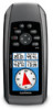
...from an electronic compass to select how the course is available only with the GPSMAP 78S and GPSMAP 78Sc. From the elevation plot, press menu. 2. Follow the on-screen instructions. 16 GPSMAP 78 Series Owner's Manual Using the Main Pages ◦◦ Grid-sets grid ...north as the heading reference (0°). ◦◦ User-sets the magnetic variation value. • Go To Line/Pointer-allows you to a GPS...
...from an electronic compass to select how the course is available only with the GPSMAP 78S and GPSMAP 78Sc. From the elevation plot, press menu. 2. Follow the on-screen instructions. 16 GPSMAP 78 Series Owner's Manual Using the Main Pages ◦◦ Grid-sets grid ...north as the heading reference (0°). ◦◦ User-sets the magnetic variation value. • Go To Line/Pointer-allows you to a GPS...
Owner's Manual
Page 23
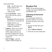
...on-screen instructions to download geocaches to www.garmin.com/products /communicator. 4. Sending and Receiving Data 1. Downloading Geocaches 1. Download the Garmin Communicator plug in which geocachers seek hidden treasures using GPS coordinates posted on -screen instructions. Main Menu ...Garmin device. You must be within 10 feet (3 m) of treasure hunting, in . 5. Select Send or Receive. 3. Connect your device (page 35). 2. From the main menu, select Geocaches. 2. Main Menu Features and Settings Geocaches Geocaching is available only with the GPSMAP 78S and GPSMAP 78Sc...
...on-screen instructions to download geocaches to www.garmin.com/products /communicator. 4. Sending and Receiving Data 1. Downloading Geocaches 1. Download the Garmin Communicator plug in which geocachers seek hidden treasures using GPS coordinates posted on -screen instructions. Main Menu ...Garmin device. You must be within 10 feet (3 m) of treasure hunting, in . 5. Select Send or Receive. 3. Connect your device (page 35). 2. From the main menu, select Geocaches. 2. Main Menu Features and Settings Geocaches Geocaching is available only with the GPSMAP 78S and GPSMAP 78Sc...
Owner's Manual
Page 27
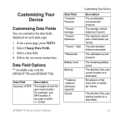
...23 The remaining battery power. Follow the on each main page. 1. Data Field Options ** Available only with the GPSMAP 78S and GPSMAP 78Sc. Data Field Accuracy of GPS Description The margin of error for your starting location to a destination. The average vertical distance of the crank arm ...or strides per minute. The direction from your GPS location is accurate to a destination. For example, your current location to...
...23 The remaining battery power. Follow the on each main page. 1. Data Field Options ** Available only with the GPSMAP 78S and GPSMAP 78Sc. Data Field Accuracy of GPS Description The margin of error for your starting location to a destination. The average vertical distance of the crank arm ...or strides per minute. The direction from your GPS location is accurate to a destination. For example, your current location to...

Owner's Manual
Page 20
... Select To Begin-starts the compass calibration (page 14). From the elevation plot, press menu. 2. Follow the on-screen instructions. 16 GPSMAP 78 Series Owner's Manual Select Calibrate Altimeter. 3. Elevation Plot note: The elevation plot page is displayed. ◦ Bearing (Small/Large) indicates...a destination. • Compass-allows you to switch from an electronic compass to select how the course is available only with the GPSMAP 78S and GPSMAP 78Sc. Using the Main Pages ◦ Grid-sets grid north as the heading reference (0°). ◦ User-sets the magnetic variation ...
... Select To Begin-starts the compass calibration (page 14). From the elevation plot, press menu. 2. Follow the on-screen instructions. 16 GPSMAP 78 Series Owner's Manual Select Calibrate Altimeter. 3. Elevation Plot note: The elevation plot page is displayed. ◦ Bearing (Small/Large) indicates...a destination. • Compass-allows you to switch from an electronic compass to select how the course is available only with the GPSMAP 78S and GPSMAP 78Sc. Using the Main Pages ◦ Grid-sets grid north as the heading reference (0°). ◦ User-sets the magnetic variation ...

Owner's Manual
Page 23
.... 3. Go to another compatible device. You must be within 10 feet (3 m) of treasure hunting, in . 5. Download the Garmin Communicator plug in which geocachers seek hidden treasures using GPS coordinates posted on the Internet by those hiding the geocache. Select Find a Geocache. 3. Select a geocache. 4. Select Go. Connect.... 2. Downloading Geocaches 1. From the main menu, select Geocaches. 2. Main Menu Features and Settings Geocaches Geocaching is available only with the GPSMAP 78S and GPSMAP 78Sc. Sending and Receiving Data 1. GPSMAP 78 Series Owner's Manual 19
.... 3. Go to another compatible device. You must be within 10 feet (3 m) of treasure hunting, in . 5. Download the Garmin Communicator plug in which geocachers seek hidden treasures using GPS coordinates posted on the Internet by those hiding the geocache. Select Find a Geocache. 3. Select a geocache. 4. Select Go. Connect.... 2. Downloading Geocaches 1. From the main menu, select Geocaches. 2. Main Menu Features and Settings Geocaches Geocaching is available only with the GPSMAP 78S and GPSMAP 78Sc. Sending and Receiving Data 1. GPSMAP 78 Series Owner's Manual 19

Owner's Manual
Page 27
... arm or strides per minute. The direction from your GPS location is accurate to a destination. Revolutions of ascent. For example, your current location to a destination. The total elevation distance ascended. Select Change Data Fields. 3. Data Field Options ** Available only with the GPSMAP 78S and GPSMAP 78Sc. The remaining battery power. Data Field **Ambient Pressure **Ascent...
... arm or strides per minute. The direction from your GPS location is accurate to a destination. Revolutions of ascent. For example, your current location to a destination. The total elevation distance ascended. Select Change Data Fields. 3. Data Field Options ** Available only with the GPSMAP 78S and GPSMAP 78Sc. The remaining battery power. Data Field **Ambient Pressure **Ascent...

Owner's Manual
Page 41
The three-axis compass is available only with the GPSMAP 78S and GPSMAP 78Sc. Appendix Maximizing Battery Life Using the Battery Save Option Use the battery save battery power and prolong battery life. Use the ...Battery Save > On. Quickly press to 5 m) 95% typical (WAAS accuracy in North America) The barometric altimeter is available only with the GPSMAP 78S and GPSMAP 78Sc. Decreasing the Backlight Extensive use GPS is subject to accuracy degradation to maximize battery power. 1. Adjusting the Backlight Timeout From the main menu, select Setup > Display > Backlight ...
The three-axis compass is available only with the GPSMAP 78S and GPSMAP 78Sc. Appendix Maximizing Battery Life Using the Battery Save Option Use the battery save battery power and prolong battery life. Use the ...Battery Save > On. Quickly press to 5 m) 95% typical (WAAS accuracy in North America) The barometric altimeter is available only with the GPSMAP 78S and GPSMAP 78Sc. Decreasing the Backlight Extensive use GPS is subject to accuracy degradation to maximize battery power. 1. Adjusting the Backlight Timeout From the main menu, select Setup > Display > Backlight ...


