Important Safety and Product Information
Page 2
...and its components contain chemicals known to the State of authorized government charts. See www.garmin.com/prop65 for various purposes, such as a waste electronics treatment facility, to cause ...Garmin is prohibitively expensive. For safety, always resolve any purpose requiring precise measurement of certain electronics. Important Safety and Product Information Warnings Failure to avoid the following potentially hazardous situations could cause an accident or collision resulting in property damage, serious injury, or death. • NOTE: Refer to your product's owner's manual...
...and its components contain chemicals known to the State of authorized government charts. See www.garmin.com/prop65 for various purposes, such as a waste electronics treatment facility, to cause ...Garmin is prohibitively expensive. For safety, always resolve any purpose requiring precise measurement of certain electronics. Important Safety and Product Information Warnings Failure to avoid the following potentially hazardous situations could cause an accident or collision resulting in property damage, serious injury, or death. • NOTE: Refer to your product's owner's manual...
Installation Instructions
Page 5
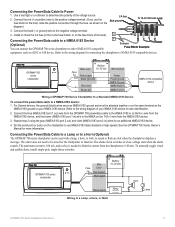
... your NMEA 0183 device for an additional NMEA 0183 device. 4. To manually toggle visual and audible alerts, install single-pole, single-throw switches. GPSMAP 700 series chartplotter + Battery - To 10-32 Vdc boat supply 23A 3. For Garmin devices, the ground (black) wires serve as shown on the diagram.)...a NMEA 0183 Device (Optional) You can be attached together or on the same terminal as a DSC or AIS device. See the GPSMAP 700 Series Owner's Manual for the chartplotter to Power 1. The alarm does not need to be wired for more information. The maximum current is 100 mA, ...
... your NMEA 0183 device for an additional NMEA 0183 device. 4. To manually toggle visual and audible alerts, install single-pole, single-throw switches. GPSMAP 700 series chartplotter + Battery - To 10-32 Vdc boat supply 23A 3. For Garmin devices, the ground (black) wires serve as shown on the diagram.)...a NMEA 0183 Device (Optional) You can be attached together or on the same terminal as a DSC or AIS device. See the GPSMAP 700 Series Owner's Manual for the chartplotter to Power 1. The alarm does not need to be wired for more information. The maximum current is 100 mA, ...
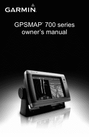
Owner's Manual
Page 1
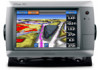
GPSMAP® 700 series owner's manual
GPSMAP® 700 series owner's manual
Owner's Manual
Page 3
...; WARNING See the Important Safety and Product Information guide in the product box for the following products: • GPSMAP® 720/720s • GPSMAP 740/740s • GPSMAP 750/750s Tips and Shortcuts • Select Home from any screen to return to the Home screen. •...release to adjust the Backlight and Color Mode settings. • Press and hold to select it. This manual includes information for product warnings and other important information. GPSMAP 700 Series Owner's Manual i For example, if you see "select Charts > Navigation Chart," you should select each item in ...
...; WARNING See the Important Safety and Product Information guide in the product box for the following products: • GPSMAP® 720/720s • GPSMAP 740/740s • GPSMAP 750/750s Tips and Shortcuts • Select Home from any screen to return to the Home screen. •...release to adjust the Backlight and Color Mode settings. • Press and hold to select it. This manual includes information for product warnings and other important information. GPSMAP 700 Series Owner's Manual i For example, if you see "select Charts > Navigation Chart," you should select each item in ...

Owner's Manual
Page 4
...22 Combination Screen Configuration 22 Navigation 25 Basic Navigation Questions 25 Navigation with a Chartplotter 25 Waypoints 26 Routes 28 Tracks 30 Navigating with a Garmin Autopilot 32 Where To 33 Marine Services Destinations 33 Almanac, On-boat, and Environmental Data 36 Almanac Data 36 On-boat Data 38 ...GPS Satellite Locations 85 Using WAAS/EGNOS 85 System Information 85 NMEA 0183 and NMEA 2000 86 Registering Your Device 89 Contacting Garmin Product Support 89 Declaration of Conformity 89 Software License Agreement 89 Index 90 ii GPSMAP 700 Series Owner's Manual
...22 Combination Screen Configuration 22 Navigation 25 Basic Navigation Questions 25 Navigation with a Chartplotter 25 Waypoints 26 Routes 28 Tracks 30 Navigating with a Garmin Autopilot 32 Where To 33 Marine Services Destinations 33 Almanac, On-boat, and Environmental Data 36 Almanac Data 36 On-boat Data 38 ...GPS Satellite Locations 85 Using WAAS/EGNOS 85 System Information 85 NMEA 0183 and NMEA 2000 86 Registering Your Device 89 Contacting Garmin Product Support 89 Declaration of Conformity 89 Software License Agreement 89 Index 90 ii GPSMAP 700 Series Owner's Manual
Owner's Manual
Page 5
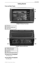
Front and Back Panels Getting Started Getting Started ➊ ➋ ➌ GPSMAP 700 Series Front View ➊ Power key ➋ Automatic backlight sensor ➌ SD card slot ➊ ➌ GPSMAP 700 Series Back View ➊ NMEA 2000 connector ➋ Power/data connector ➌ Radar Port ➍ External GPS antenna connector Turning On the Chartplotter Press and release . GPSMAP 700 Series Owner's Manual ➋ ➍ 1 Turning Off the Chartplotter Press and hold .
Front and Back Panels Getting Started Getting Started ➊ ➋ ➌ GPSMAP 700 Series Front View ➊ Power key ➋ Automatic backlight sensor ➌ SD card slot ➊ ➌ GPSMAP 700 Series Back View ➊ NMEA 2000 connector ➋ Power/data connector ➌ Radar Port ➍ External GPS antenna connector Turning On the Chartplotter Press and release . GPSMAP 700 Series Owner's Manual ➋ ➍ 1 Turning Off the Chartplotter Press and hold .
Owner's Manual
Page 6
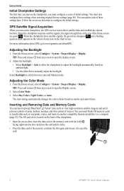
... flashing question mark appears on the vehicle (boat) icon on sunrise and sunset times. Adjusting the Backlight 1. Select Backlight to www.garmin.com/aboutGPS. TIP: Press and release from any screen to open the display screen. 2. The Auto setting automatically changes the color ... and Memory Cards You can insert optional BlueChart® g2 Vision® data cards to eject the card. ➊ 2 GPSMAP 700 Series Owner's Manual Getting Started Initial Chartplotter Settings The first time you must also configure these settings later. GPS Satellite Signal Acquisition When you turn ...
... flashing question mark appears on the vehicle (boat) icon on sunrise and sunset times. Adjusting the Backlight 1. Select Backlight to www.garmin.com/aboutGPS. TIP: Press and release from any screen to open the display screen. 2. The Auto setting automatically changes the color ... and Memory Cards You can insert optional BlueChart® g2 Vision® data cards to eject the card. ➊ 2 GPSMAP 700 Series Owner's Manual Getting Started Initial Chartplotter Settings The first time you must also configure these settings later. GPS Satellite Signal Acquisition When you turn ...
Owner's Manual
Page 7
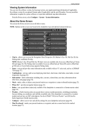
...North America only). • Configure-allows you to view and edit the settings for an optional Garmin radar (if applicable), and the unit ID number. GPSMAP 700 Series Owner's Manual 3 About the Home Screen You can view the software version, the basemap version, any supplemental ...Where To?-provides navigation features (page 33). • Radar-sets up and shows radar (only available if the chartplotter is connected to a Garmin marine radar) (page 54). • Weather-(North America only) sets up and shows various weather parameters, including precipitation, forecast, fishing, sea...
...North America only). • Configure-allows you to view and edit the settings for an optional Garmin radar (if applicable), and the unit ID number. GPSMAP 700 Series Owner's Manual 3 About the Home Screen You can view the software version, the basemap version, any supplemental ...Where To?-provides navigation features (page 33). • Radar-sets up and shows radar (only available if the chartplotter is connected to a Garmin marine radar) (page 54). • Weather-(North America only) sets up and shows various weather parameters, including precipitation, forecast, fishing, sea...
Owner's Manual
Page 8
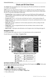
... Navigation chart or the Fishing chart (page 61). Changing from supplemental maps, if available. Charts and 3D Chart Views Charts and 3D Chart Views The GPSMAP 700 series chartplotters have a basic imagery map. From the Home screen, select Charts > Navigation Chart. ➊ ➋ ➌ ➍ ➎ ➏ ➐ Navigation Chart with... behind the boat for depth recognition (page 19). • Radar Overlay-superimposes radar information on the map. Select and to a Different Chart 1. The bar under 4 GPSMAP 700 Series Owner's Manual
... Navigation chart or the Fishing chart (page 61). Changing from supplemental maps, if available. Charts and 3D Chart Views Charts and 3D Chart Views The GPSMAP 700 series chartplotters have a basic imagery map. From the Home screen, select Charts > Navigation Chart. ➊ ➋ ➌ ➍ ➎ ➏ ➐ Navigation Chart with... behind the boat for depth recognition (page 19). • Radar Overlay-superimposes radar information on the map. Select and to a Different Chart 1. The bar under 4 GPSMAP 700 Series Owner's Manual
Owner's Manual
Page 9
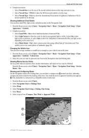
.... Note: The Fishing chart is due to avoid land, shallow water, and other obstacles. Follow the magenta line, steering to provide continuous map coverage. 4. GPSMAP 700 Series Owner's Manual 5 Complete an action: • Select Go To to navigate directly to the location. • Select Route To to create a route to the location, including...
.... Note: The Fishing chart is due to avoid land, shallow water, and other obstacles. Follow the magenta line, steering to provide continuous map coverage. 4. GPSMAP 700 Series Owner's Manual 5 Complete an action: • Select Go To to navigate directly to the location. • Select Route To to create a route to the location, including...
Owner's Manual
Page 10
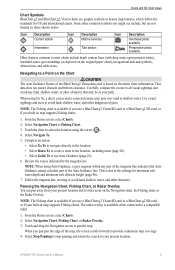
.... • Select Symbol Only to display only the symbol. • Select Comment to display any comments you selected. 4. Select a chart or a 3D chart view. 6 GPSMAP 700 Series Owner's Manual Viewing Location and Object Information on a Chart You can view information about a location or an object on the Navigation chart or the Fishing chart...
.... • Select Symbol Only to display only the symbol. • Select Comment to display any comments you selected. 4. Select a chart or a 3D chart view. 6 GPSMAP 700 Series Owner's Manual Viewing Location and Object Information on a Chart You can view information about a location or an object on the Navigation chart or the Fishing chart...
Owner's Manual
Page 11
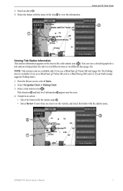
... name of the item ➋ to help predict the tide level at different times or on the chart with the station name. ➌ ➋ ➊ GPSMAP 700 Series Owner's Manual 7
... name of the item ➋ to help predict the tide level at different times or on the chart with the station name. ➌ ➋ ➊ GPSMAP 700 Series Owner's Manual 7
Owner's Manual
Page 12
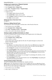
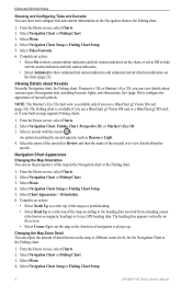
... Fishing chart. 1. Select Navigation Chart or Fishing Chart. 3. Select Navigation Chart Setup or Fishing Chart Setup. 5. Select Navigation Chart Setup or Fishing Chart Setup. 8 GPSMAP 700 Series Owner's Manual Navigation Chart Appearance Changing the Map Orientation You can set the map so the direction of the map in map supports Fishing charts. 1. Select...
... Fishing chart. 1. Select Navigation Chart or Fishing Chart. 3. Select Navigation Chart Setup or Fishing Chart Setup. 5. Select Navigation Chart Setup or Fishing Chart Setup. 8 GPSMAP 700 Series Owner's Manual Navigation Chart Appearance Changing the Map Orientation You can set the map so the direction of the map in map supports Fishing charts. 1. Select...

Owner's Manual
Page 13
Select Chart Appearance > Detail. 6. The basic world map is available on the chart. Select Chart Appearance. 6. Heading Line 1. GPSMAP 700 Series Owner's Manual 9 These differences are available if you use a BlueChart g2 Vision SD card. Select Navigation Chart Setup or Fishing Chart Setup. ... > Change Distance, enter the distance to see the detailed charts. Select Menu. 4. Use the slider bar to show basic map data on all GPSMAP 700 series chartplotters. 1. Complete an action: • Select World Map > Full to show shaded relief on the chart. • Select World Map...
Select Chart Appearance > Detail. 6. The basic world map is available on the chart. Select Chart Appearance. 6. Heading Line 1. GPSMAP 700 Series Owner's Manual 9 These differences are available if you use a BlueChart g2 Vision SD card. Select Navigation Chart Setup or Fishing Chart Setup. ... > Change Distance, enter the distance to see the detailed charts. Select Menu. 4. Use the slider bar to show basic map data on all GPSMAP 700 series chartplotters. 1. Complete an action: • Select World Map > Full to show shaded relief on the chart. • Select World Map...
Owner's Manual
Page 14
... heading information is available from a heading sensor and the source heading is set a dangerous depth. Select Spot Depths > Dangerous. 3. Select Chart Appearance > Symbols. 10 GPSMAP 700 Series Owner's Manual Select Navigation Chart or Fishing Chart. 3. From the Home screen, select Charts. 2. Select Navigation Chart Setup or Fishing Chart Setup. 5. Showing and Configuring Navaid...
... heading information is available from a heading sensor and the source heading is set a dangerous depth. Select Spot Depths > Dangerous. 3. Select Chart Appearance > Symbols. 10 GPSMAP 700 Series Owner's Manual Select Navigation Chart or Fishing Chart. 3. From the Home screen, select Charts. 2. Select Navigation Chart Setup or Fishing Chart Setup. 5. Showing and Configuring Navaid...
Owner's Manual
Page 15
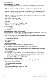
... icon on the zoom level. • Select Photo Points > On to view aerial photos of rose (Compass, True Wind, or Apparent Wind). ➋ ➊ GPSMAP 700 Series Owner's Manual 11 Charts and 3D Chart Views 6. Select Navigation Chart or Fishing Chart. 3. From the Home screen, select Charts > Navigation Chart > Menu > Navigation Chart Setup...
... icon on the zoom level. • Select Photo Points > On to view aerial photos of rose (Compass, True Wind, or Apparent Wind). ➋ ➊ GPSMAP 700 Series Owner's Manual 11 Charts and 3D Chart Views 6. Select Navigation Chart or Fishing Chart. 3. From the Home screen, select Charts > Navigation Chart > Menu > Navigation Chart Setup...
Owner's Manual
Page 16
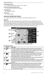
... does not appear (page 14). Using Waypoints See "Waypoints" (page 26). About AIS AIS alerts you discontinue vessel tracking, the lost , a message banner appears. 12 GPSMAP 700 Series Owner's Manual
... does not appear (page 14). Using Waypoints See "Waypoints" (page 26). About AIS AIS alerts you discontinue vessel tracking, the lost , a message banner appears. 12 GPSMAP 700 Series Owner's Manual

Owner's Manual
Page 17
... vessels. If an activated AIS target is not transmitting speed information, or if the vessel is not moving, a projected course line does not appear. GPSMAP 700 Series Owner's Manual 13 If you discontinue vessel tracking, the lost . Heading and Projected Course of Activated AIS Targets When heading and course over ground, or the...
... vessels. If an activated AIS target is not transmitting speed information, or if the vessel is not moving, a projected course line does not appear. GPSMAP 700 Series Owner's Manual 13 If you discontinue vessel tracking, the lost . Heading and Projected Course of Activated AIS Targets When heading and course over ground, or the...
Owner's Manual
Page 18
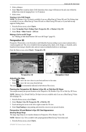
...'s Eye 3D. 3. Select Navigation Chart, Fishing Chart, Perspective 3D, or Mariner's Eye 3D. 3. Select AIS Vessel. to 2.0 nm (or from 150 m to 2.0 mi.). 14 GPSMAP 700 Series Owner's Manual Note: The Mariner's Eye 3D chart is applied only to that chart or to that 3D chart view. Touch an AIS vessel. 4. From the...
...'s Eye 3D. 3. Select Navigation Chart, Fishing Chart, Perspective 3D, or Mariner's Eye 3D. 3. Select AIS Vessel. to 2.0 nm (or from 150 m to 2.0 mi.). 14 GPSMAP 700 Series Owner's Manual Note: The Mariner's Eye 3D chart is applied only to that chart or to that 3D chart view. Touch an AIS vessel. 4. From the...
Owner's Manual
Page 19
... screen to your boat and lower to the water. • Select to move the view closer to visualize distances in map supports Fishing charts. 1. GPSMAP 700 Series Owner's Manual 15 The Fishing chart is available with a preprogrammed BlueChart g2 Vision data card. 1. From the Home screen, select Charts. 2. Select Navigation Chart, Fishing Chart...
... screen to your boat and lower to the water. • Select to move the view closer to visualize distances in map supports Fishing charts. 1. GPSMAP 700 Series Owner's Manual 15 The Fishing chart is available with a preprogrammed BlueChart g2 Vision data card. 1. From the Home screen, select Charts. 2. Select Navigation Chart, Fishing Chart...

