Installation Instructions
Page 1
... photocopy, in Taiwan Chartplotter serial number: GPS 17x serial number: To install the GPSMAP 6000/7000 series chartplotter, you have been included for your Garmin dealer immediately. Connect the GPSMAP 6000/7000 series chartplotter to an existing NMEA 2000 network or create a simple NMEA ... the GPS antenna (page 4). 3. The serial numbers are not necessary in order to use the GPSMAP 6000/7000 chartplotter. The GPSMAP 6000/7000 series chartplotter and GPS 17x antenna must : 1. GPSMAP® 6000/7000 Series Installation Instructions WARNING See the Important Safety ...
... photocopy, in Taiwan Chartplotter serial number: GPS 17x serial number: To install the GPSMAP 6000/7000 series chartplotter, you have been included for your Garmin dealer immediately. Connect the GPSMAP 6000/7000 series chartplotter to an existing NMEA 2000 network or create a simple NMEA ... the GPS antenna (page 4). 3. The serial numbers are not necessary in order to use the GPSMAP 6000/7000 chartplotter. The GPSMAP 6000/7000 series chartplotter and GPS 17x antenna must : 1. GPSMAP® 6000/7000 Series Installation Instructions WARNING See the Important Safety ...
Owner's Manual
Page 3
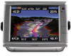
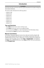
...Safety and Product Information guide in order. For example, if you see "select Charts > Navigation Chart," you should press the Charts soft key (GPSMAP 6000 series) or touch Charts (GPSMAP 7000 series), and then press or touch Navigation Chart. GPSMAP® 6000/7000 Series Owner's...should select each item in the product box for the following products: • GPSMAP® 6008 • GPSMAP 6208 • GPSMAP 6012 • GPSMAP 6212 • GPSMAP 7012 • GPSMAP 7212 • GPSMAP 7015 • GPSMAP 7215 Tips and Shortcuts • Select Home from any screen to return to the...
...Safety and Product Information guide in order. For example, if you see "select Charts > Navigation Chart," you should press the Charts soft key (GPSMAP 6000 series) or touch Charts (GPSMAP 7000 series), and then press or touch Navigation Chart. GPSMAP® 6000/7000 Series Owner's...should select each item in the product box for the following products: • GPSMAP® 6008 • GPSMAP 6208 • GPSMAP 6012 • GPSMAP 6212 • GPSMAP 7012 • GPSMAP 7212 • GPSMAP 7015 • GPSMAP 7215 Tips and Shortcuts • Select Home from any screen to return to the...
Owner's Manual
Page 68
...be configured separately. You can appear on -screen keyboard. For the GPSMAP 7000 series, use the Rocker or the Numeric Keypad to set the units of measure the chartplotter shows, using a Garmin sounder module in order to appear on one chart or one 3D chart view does not appear..., fishing, fuel, sailing, and compass tape data bars are available with a preprogrammed BlueChart g2 Vision data card. 62 GPSMAP® 6000/7000 Series Owner's Manual For the GPSMAP 6000 series, use the on specific charts and 3D chart views, and they provide real-time, at-a-glance information. Data...
...be configured separately. You can appear on -screen keyboard. For the GPSMAP 7000 series, use the Rocker or the Numeric Keypad to set the units of measure the chartplotter shows, using a Garmin sounder module in order to appear on one chart or one 3D chart view does not appear..., fishing, fuel, sailing, and compass tape data bars are available with a preprogrammed BlueChart g2 Vision data card. 62 GPSMAP® 6000/7000 Series Owner's Manual For the GPSMAP 6000 series, use the on specific charts and 3D chart views, and they provide real-time, at-a-glance information. Data...

Owner's Manual
Page 88
... Offset to navigate parallel to the route, offset from the destination point used when the route was created, to the left of original route. 82 GPSMAP® 6000/7000 Series Owner's Manual Complete an action: • Select Forward - Port to navigate the route from it by the magenta line. ...8. Navigation lines must be showing in order to view a route on the Radar screen (page 94). 1. Navigation lines must be showing in the route, steering to the right of original route. ...
... Offset to navigate parallel to the route, offset from the destination point used when the route was created, to the left of original route. 82 GPSMAP® 6000/7000 Series Owner's Manual Complete an action: • Select Forward - Port to navigate the route from it by the magenta line. ...8. Navigation lines must be showing in order to view a route on the Radar screen (page 94). 1. Navigation lines must be showing in the route, steering to the right of original route. ...

Owner's Manual
Page 91
...and clutter settings configured for viewing information about nearby objects more difficult to view information about distant weather conditions? • Assess the environmental conditions in order to the Radar screen. The chartplotter does not readjust the gain automatically in one radar mode are using a GMR 20, 21, 40, 41,... 18, 18 HD, 24, 24 HD, 404, or 406, all modes GPSMAP® 6000/7000 Series Owner's Manual 85 To optimize the radar appearance for all gain and clutter settings configured for the gain, Auto, sets the...
...and clutter settings configured for viewing information about nearby objects more difficult to view information about distant weather conditions? • Assess the environmental conditions in order to the Radar screen. The chartplotter does not readjust the gain automatically in one radar mode are using a GMR 20, 21, 40, 41,... 18, 18 HD, 24, 24 HD, 404, or 406, all modes GPSMAP® 6000/7000 Series Owner's Manual 85 To optimize the radar appearance for all gain and clutter settings configured for the gain, Auto, sets the...
Owner's Manual
Page 101
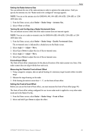
... within which the radar scanner does not transmit signals. Setting the Front-of-boat Offset Before you can set the antenna size for use in order to adjust the offset. From the Home screen, select Radar > Radar Setup > Front of -boat Offset 1. Select Up or Down to be configured" message appears...
... within which the radar scanner does not transmit signals. Setting the Front-of-boat Offset Before you can set the antenna size for use in order to adjust the offset. From the Home screen, select Radar > Radar Setup > Front of -boat Offset 1. Select Up or Down to be configured" message appears...
Owner's Manual
Page 114
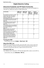
... to a VHF radio over a NMEA 0183 network or a NMEA 2000 network. NMEA 2000 VHF Radio X X X Garmin NMEA 0183 VHF Radio X X X Turning On DSC From the Home screen, select Configure > Other Vessels > DSC....DSC List The DSC list is received from the same boat, it replaces the first call in order to view the DSC list. Viewing the DSC List Your chartplotter must be connected to a VHF... quickly set up to 100 entries. From the Home screen, select Information > DSC List. 108 GPSMAP® 6000/7000 Series Owner's Manual The chartplotter allows you initiate a man-overboard distress call from...
... to a VHF radio over a NMEA 0183 network or a NMEA 2000 network. NMEA 2000 VHF Radio X X X Garmin NMEA 0183 VHF Radio X X X Turning On DSC From the Home screen, select Configure > Other Vessels > DSC....DSC List The DSC list is received from the same boat, it replaces the first call in order to view the DSC list. Viewing the DSC List Your chartplotter must be connected to a VHF... quickly set up to 100 entries. From the Home screen, select Information > DSC List. 108 GPSMAP® 6000/7000 Series Owner's Manual The chartplotter allows you initiate a man-overboard distress call from...

Owner's Manual
Page 117
... 2. Deleting a Position-Report Call 1. Vessel Trails on the Navigation Chart You can view trails for all tracked vessels on the Navigation Chart GPSMAP® 6000/7000 Series Owner's Manual 111 Note: The Fishing chart and Mariner's Eye 3D are available with a preprogrammed BlueChart g2 Vision...8226; Select Comment. For the GPSMAP 7000 series, use the on -screen keyboard. By default, a black dot appears for the trail line. A black line indicating the path of the vessel. • Select Trail Line. Digital Selective Calling Editing Information in order to view trails for tracked vessels...
... 2. Deleting a Position-Report Call 1. Vessel Trails on the Navigation Chart You can view trails for all tracked vessels on the Navigation Chart GPSMAP® 6000/7000 Series Owner's Manual 111 Note: The Fishing chart and Mariner's Eye 3D are available with a preprogrammed BlueChart g2 Vision...8226; Select Comment. For the GPSMAP 7000 series, use the on -screen keyboard. By default, a black dot appears for the trail line. A black line indicating the path of the vessel. • Select Trail Line. Digital Selective Calling Editing Information in order to view trails for tracked vessels...
Supplement
Page 3
.... In Europe, go to use XM Satellite Radio, you have a Garmin XM satellite radio receiver and an XM Satellite Radio subscription. by phone at (913) 397.8200 or (800) 800.1020. In order to www.garmin.com/support, or contact Garmin USA by phone at 0808 2380000. by phone at +44 (0) 870....8501241. To use XM WX Satellite Weather®, you do not have a Garmin XM® satellite weather receiver and an activated XM WX ...
.... In Europe, go to use XM Satellite Radio, you have a Garmin XM satellite radio receiver and an XM Satellite Radio subscription. by phone at (913) 397.8200 or (800) 800.1020. In order to www.garmin.com/support, or contact Garmin USA by phone at 0808 2380000. by phone at +44 (0) 870....8501241. To use XM WX Satellite Weather®, you do not have a Garmin XM® satellite weather receiver and an activated XM WX ...
Technical Reference for Garmin NMEA 2000 Products
Page 10
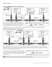
... is connected directly to another T-connector (as part of the network in this example), use the LEN from that device as shown in order to which you calculate the voltage drop in this NMEA 2000 network will Cable resistance Distance Network load function correctly. compliant device LEN = ...Length = 6 m Backbone cable Length = 20 m Backbone cable Length = 10 m When the voltage drop formula is applied to the center of the calculation for Garmin NMEA 2000 Products NMEA 2000 Fundamentals End-powered NMEA 2000 network, incorrectly designed: + - NMEA 2000- NMEA 2000-
... is connected directly to another T-connector (as part of the network in this example), use the LEN from that device as shown in order to which you calculate the voltage drop in this NMEA 2000 network will Cable resistance Distance Network load function correctly. compliant device LEN = ...Length = 6 m Backbone cable Length = 20 m Backbone cable Length = 10 m When the voltage drop formula is applied to the center of the calculation for Garmin NMEA 2000 Products NMEA 2000 Fundamentals End-powered NMEA 2000 network, incorrectly designed: + - NMEA 2000- NMEA 2000-