Quick Start Manual
Page 1
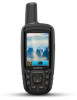
GPSMAP® 64 Quick Start Manual February 2014 190-01702-01_0B Printed in Taiwan
GPSMAP® 64 Quick Start Manual February 2014 190-01702-01_0B Printed in Taiwan

Quick Start Manual
Page 4
...www.garmin.com/ support. 2 Select Manuals. 3 Follow the on-screen instructions to select your computer. 3 Go to www.garmin.com/ express. 4 Follow the on your product. Support and Updates Garmin Express™ provides easy access to these services for information about this product on the GPSMAP 64s and GPSMAP ...page. 1 Open the page for your device. • Product registration • Product manuals • Software updates • Map updates • Vehicles, voices, and other extras Setting Up Garmin Express 1 Plug the small end of the USB cable into an available USB port ...
...www.garmin.com/ support. 2 Select Manuals. 3 Follow the on-screen instructions to select your computer. 3 Go to www.garmin.com/ express. 4 Follow the on your product. Support and Updates Garmin Express™ provides easy access to these services for information about this product on the GPSMAP 64s and GPSMAP ...page. 1 Open the page for your device. • Product registration • Product manuals • Software updates • Map updates • Vehicles, voices, and other extras Setting Up Garmin Express 1 Plug the small end of the USB cable into an available USB port ...

Owners Manual
Page 2
.... Windows® is a trademark of Microsoft Corporation in the U.S. Garmin reserves the right to change or improve its subsidiaries, registered in the content of this manual without obligation to www.thisisant.com/directory for current updates and supplemental information...person or organization of Garmin. © 2013-2016 Garmin Ltd. This product is under license. Garmin®, the Garmin logo, ANT+®, City Navigator®, and GPSMAP® are owned by Garmin is ANT+® certified. BaseCamp™, chirp™, Garmin Connect™, Garmin Express™, HomePort&#...
.... Windows® is a trademark of Microsoft Corporation in the U.S. Garmin reserves the right to change or improve its subsidiaries, registered in the content of this manual without obligation to www.thisisant.com/directory for current updates and supplemental information...person or organization of Garmin. © 2013-2016 Garmin Ltd. This product is under license. Garmin®, the Garmin logo, ANT+®, City Navigator®, and GPSMAP® are owned by Garmin is ANT+® certified. BaseCamp™, chirp™, Garmin Connect™, Garmin Express™, HomePort&#...
Owners Manual
Page 7
... Before you avoid hazards near the course, such as cars, buildings, or overhead power lines. Course Pointer The course pointer is available only with GPSMAP 64s series devices. 1 Select Sight 'N Go. 2 Point the device at which tell you how far off shading. The course deviation indicator (...trip computer values to the destination. Big Numbers: Changes the size of the compass. The map items will appear. Bearing points in or out manually. Trip Computer Settings From the trip computer, select MENU. Shaded Relief: Shows detail relief on the map. Track Up shows a topdown view ...
... Before you avoid hazards near the course, such as cars, buildings, or overhead power lines. Course Pointer The course pointer is available only with GPSMAP 64s series devices. 1 Select Sight 'N Go. 2 Point the device at which tell you how far off shading. The course deviation indicator (...trip computer values to the destination. Big Numbers: Changes the size of the compass. The map items will appear. Bearing points in or out manually. Trip Computer Settings From the trip computer, select MENU. Shaded Relief: Shows detail relief on the map. Track Up shows a topdown view ...
Owners Manual
Page 8
... a distance. Elevation/Distance: Records elevation changes over the distance traveled. NOTE: The barometric altimeter is available only with GPSMAP 64s series devices. Restoring Default Page Settings 1 Open a page for which you know the correct elevation or the correct...Data Fields: Customizes the elevation plot data fields. Calibrate Altimeter: See (Calibrating the Barometric Altimeter, page 4). Projecting a Waypoint You can manually calibrate the barometric altimeter if you will restore the settings. 2 Select MENU > Restore Defaults. Elevation Plot NOTE: The elevation plot is...
... a distance. Elevation/Distance: Records elevation changes over the distance traveled. NOTE: The barometric altimeter is available only with GPSMAP 64s series devices. Restoring Default Page Settings 1 Open a page for which you know the correct elevation or the correct...Data Fields: Customizes the elevation plot data fields. Calibrate Altimeter: See (Calibrating the Barometric Altimeter, page 4). Projecting a Waypoint You can manually calibrate the barometric altimeter if you will restore the settings. 2 Select MENU > Restore Defaults. Elevation Plot NOTE: The elevation plot is...
Owners Manual
Page 10
...the setup of the area you can send and receive data when paired with GPSMAP 64s series devices. Satellite Page The satellite page shows your device using Bluetooth®... you have attempted to calculate. 3 Select Calculate when finished. You can verify some geocaches at www.garmin.com. Deleting a Photo 1 Select Photo Viewer. 2 Select a photo. 3 Select MENU > Delete... in . 5 Follow the instructions at geocaching.com to find a geocache, you can load geocaches manually onto your current location, GPS accuracy, satellite locations, and signal strength. 6 Main Menu Features and...
...the setup of the area you can send and receive data when paired with GPSMAP 64s series devices. Satellite Page The satellite page shows your device using Bluetooth®... you have attempted to calculate. 3 Select Calculate when finished. You can verify some geocaches at www.garmin.com. Deleting a Photo 1 Select Photo Viewer. 2 Select a photo. 3 Select MENU > Delete... in . 5 Follow the instructions at geocaching.com to find a geocache, you can load geocaches manually onto your current location, GPS accuracy, satellite locations, and signal strength. 6 Main Menu Features and...
Owners Manual
Page 15
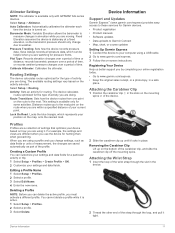
...customize your settings and data fields for Garmin devices. • Product registration • Product manuals • Software updates • Data uploads to Garmin Connect • Map, chart, or course updates Setting Up Garmin Express 1 Connect the device to www.garmin.com/express. • Keep the ... altimeter. Routing Settings The device calculates routes optimized for pressure fronts. Select Setup > Routing. This setting is available only with GPSMAP 64s series devices. Lock On Road: Locks the blue triangle, which can be helpful when you are doing . Attaching the...
...customize your settings and data fields for Garmin devices. • Product registration • Product manuals • Software updates • Data uploads to Garmin Connect • Map, chart, or course updates Setting Up Garmin Express 1 Connect the device to www.garmin.com/express. • Keep the ... altimeter. Routing Settings The device calculates routes optimized for pressure fronts. Select Setup > Routing. This setting is available only with GPSMAP 64s series devices. Lock On Road: Locks the blue triangle, which can be helpful when you are doing . Attaching the...


