Owner's Manual
Page 1
GPSMAP® 64 Owner's Manual February 2014 190-01702-00_0B Printed in Taiwan
GPSMAP® 64 Owner's Manual February 2014 190-01702-00_0B Printed in Taiwan

Owner's Manual
Page 2
... a registered trademark of their respective owners. Other trademarks and trade names are trademarks of Garmin. Garmin reserves the right to notify any use of this manual without the express permission of Garmin Ltd. Garmin®, the Garmin logo, City Navigator®, and GPSMAP® are trademarks of such marks by the Bluetooth SIG, Inc. or its products...
... a registered trademark of their respective owners. Other trademarks and trade names are trademarks of Garmin. Garmin reserves the right to notify any use of this manual without the express permission of Garmin Ltd. Garmin®, the Garmin logo, City Navigator®, and GPSMAP® are trademarks of such marks by the Bluetooth SIG, Inc. or its products...

Owner's Manual
Page 8
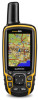
... helpful statistics. top of the map, compass, elevation plot, and trip computer. Map Information: Enables or disables the maps currently loaded on the GPSMAP 64s and GPSMAP 64st. 1 Select Sight 'N Go. 2 Point the device at an object. 3 Select Lock Direction > Set Course. 4 Navigate using the ... layout, dashboard, and data fields. Course Pointer The course pointer is available only on the device. Bearing points in or out manually. For accurate information, reset the trip information before beginning a trip. Elevation Plot NOTE: The Elevation Plot is higher than the ...
... helpful statistics. top of the map, compass, elevation plot, and trip computer. Map Information: Enables or disables the maps currently loaded on the GPSMAP 64s and GPSMAP 64st. 1 Select Sight 'N Go. 2 Point the device at an object. 3 Select Lock Direction > Set Course. 4 Navigate using the ... layout, dashboard, and data fields. Course Pointer The course pointer is available only on the device. Bearing points in or out manually. For accurate information, reset the trip information before beginning a trip. Elevation Plot NOTE: The Elevation Plot is higher than the ...

Owner's Manual
Page 9
...data. Geocaching is like a hidden treasure. chirp™ A chirp is a small Garmin accessory that is known. 2 Select PAGE > Elevation Plot > MENU > Calibrate Altimeter. 3 Follow the on the GPSMAP 64s and GPSMAP 64st. 1 Go to the geocache nearest you, select Find Next Closest. •...Searching > On. Your device can manually calibrate the barometric altimeter if you will restore the settings. 2 Select MENU > Restore Defaults. Satellite Page The satellite page shows your device to pair the device with the GPSMAP 64s and GPSMAP 64st. Clear Current Track: Deletes ...
...data. Geocaching is like a hidden treasure. chirp™ A chirp is a small Garmin accessory that is known. 2 Select PAGE > Elevation Plot > MENU > Calibrate Altimeter. 3 Follow the on the GPSMAP 64s and GPSMAP 64st. 1 Go to the geocache nearest you, select Find Next Closest. •...Searching > On. Your device can manually calibrate the barometric altimeter if you will restore the settings. 2 Select MENU > Restore Defaults. Satellite Page The satellite page shows your device to pair the device with the GPSMAP 64s and GPSMAP 64st. Clear Current Track: Deletes ...
Owner's Manual
Page 14
...to turn on your settings and data fields. From the main menu, select Setup > System > Satellite System > GPS. Support and Updates Garmin Express™ provides easy access to these services for in-country support information. • In the USA, call (913) 397. 8200 ...to maximize the battery life. Alkaline batteries can customize your settings and data fields for your device. • Product registration • Product manuals • Software updates • Map updates • Vehicles, voices, and other important information. Creating a Custom Profile You can rupture at...
...to turn on your settings and data fields. From the main menu, select Setup > System > Satellite System > GPS. Support and Updates Garmin Express™ provides easy access to these services for in-country support information. • In the USA, call (913) 397. 8200 ...to maximize the battery life. Alkaline batteries can customize your settings and data fields for your device. • Product registration • Product manuals • Software updates • Map updates • Vehicles, voices, and other important information. Creating a Custom Profile You can rupture at...

Quick Start Manual
Page 1
GPSMAP® 64 Quick Start Manual February 2014 190-01702-01_0B Printed in Taiwan
GPSMAP® 64 Quick Start Manual February 2014 190-01702-01_0B Printed in Taiwan

Quick Start Manual
Page 4
...manuals • Software updates • Map updates • Vehicles, voices, and other helpful statistics. NOTE: Sight 'N Go is known. 2 Select PAGE > Elevation Plot > MENU > Calibrate Altimeter. 3 Follow the on -screen instructions to the object. NOTE: The barometric altimeter is available only on the GPSMAP 64s and GPSMAP 64st. 1 Go to www.garmin....com/ express. 4 Follow the on the Garmin website. • Go to www.garmin.com/ outdoor. • Go to www.garmin.com/ learningcenter. • ...
...manuals • Software updates • Map updates • Vehicles, voices, and other helpful statistics. NOTE: Sight 'N Go is known. 2 Select PAGE > Elevation Plot > MENU > Calibrate Altimeter. 3 Follow the on -screen instructions to the object. NOTE: The barometric altimeter is available only on the GPSMAP 64s and GPSMAP 64st. 1 Go to www.garmin....com/ express. 4 Follow the on the Garmin website. • Go to www.garmin.com/ outdoor. • Go to www.garmin.com/ learningcenter. • ...


