Owner's Manual
Page 3
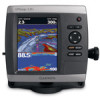
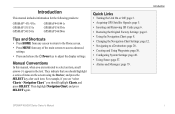
... Settings: page 12. • Navigating to select an item, small arrows (>) appear in the text. Introduction This manual includes information for the following products: GPSMAP® 431/431s GPSMAP 531/531s GPSMAP 541/541s GPSMAP 441/441s GPSMAP 536/536s GPSMAP 546/546s Tips and Shortcuts • Press HOME from any screen to return to the Home screen. •...
... Settings: page 12. • Navigating to select an item, small arrows (>) appear in the text. Introduction This manual includes information for the following products: GPSMAP® 431/431s GPSMAP 531/531s GPSMAP 541/541s GPSMAP 441/441s GPSMAP 536/536s GPSMAP 546/546s Tips and Shortcuts • Press HOME from any screen to return to the Home screen. •...

Owner's Manual
Page 57
... line. From the Home screen, select Configure > Communications > NMEA 0183 Setup. 2. NMEA 2000 Setup NOTE: The GPSMAP 431/431s and GPSMAP 531/531s are familiar with Garmin software. • NMEA Standard-supports the input or output of standard NMEA 0183 data, DSC, and sonar NMEA input.... Select a setting (Sounder, Route, System, or Garmin). 3. If you are not NMEA 2000 compatible. 51 Serial Port 1-configures the input/output format for the DPT, MTW, and VHW sentences. • GPSMAP 400/500 Series Owner's Manual Configuring the Chartplotter • NMEA High Speed-supports the...
... line. From the Home screen, select Configure > Communications > NMEA 0183 Setup. 2. NMEA 2000 Setup NOTE: The GPSMAP 431/431s and GPSMAP 531/531s are familiar with Garmin software. • NMEA Standard-supports the input or output of standard NMEA 0183 data, DSC, and sonar NMEA input.... Select a setting (Sounder, Route, System, or Garmin). 3. If you are not NMEA 2000 compatible. 51 Serial Port 1-configures the input/output format for the DPT, MTW, and VHW sentences. • GPSMAP 400/500 Series Owner's Manual Configuring the Chartplotter • NMEA High Speed-supports the...
Owner's Manual
Page 63
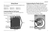
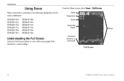
... GPSMAP 531s GPSMAP 536s GPSMAP 541s GPSMAP 546s Understanding the Full Screen Select the Full Screen option to display sonar information on the ring when it is received at the depth indicated. The scale indicates what is beneath your boat. Depth of sonar readings Transducer frequency or beam width Full Screen GPSMAP 400/500 Series Owner's Manual...
... GPSMAP 531s GPSMAP 536s GPSMAP 541s GPSMAP 546s Understanding the Full Screen Select the Full Screen option to display sonar information on the ring when it is received at the depth indicated. The scale indicates what is beneath your boat. Depth of sonar readings Transducer frequency or beam width Full Screen GPSMAP 400/500 Series Owner's Manual...
Owner's Manual
Page 83
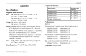
...diagonal (10.6 cm), QVGA display with adjustable brightness, 320 × 234 pixels. GPSMAP 531/541: 5.0 in . GPSMAP 536/546: 5.0 in . GPSMAP 536/536s GPSMAP 546/546s Update Rate: once per second GPSMAP 400/500 Series Owner's Manual 77 diagonal (12.7 cm), QVGA display with adjustable brightness, 320 × 240...to 55ºC) Appendix Compass-Safe Distances: Model Number GPSMAP 536/546 GPSMAP 431/441 GPSMAP 531/541 Compass-Safe Distance 20 in. (50 cm) 26 in. (65) cm 30 in . GPSMAP 431/431s GPSMAP 441/441s GPSMAP 531/531s GPSMAP 541/541s High-sensitivity, 12 parallel channel, WAAS-capable...
...diagonal (10.6 cm), QVGA display with adjustable brightness, 320 × 234 pixels. GPSMAP 531/541: 5.0 in . GPSMAP 536/546: 5.0 in . GPSMAP 536/536s GPSMAP 546/546s Update Rate: once per second GPSMAP 400/500 Series Owner's Manual 77 diagonal (12.7 cm), QVGA display with adjustable brightness, 320 × 240...to 55ºC) Appendix Compass-Safe Distances: Model Number GPSMAP 536/546 GPSMAP 431/441 GPSMAP 531/541 Compass-Safe Distance 20 in. (50 cm) 26 in. (65) cm 30 in . GPSMAP 431/431s GPSMAP 441/441s GPSMAP 531/531s GPSMAP 541/541s High-sensitivity, 12 parallel channel, WAAS-capable...
Owner's Manual
Page 84
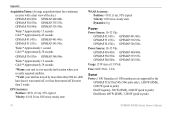
Appendix Acquisition Times: (Average acquisition times for a stationary receiver with a clear view of the sky) GPSMAP 431/431s GPSMAP 441/441s GPSMAP 531/531s GPSMAP 541/541s Warm:* Approximately 1 second Cold:** Approximately 38 seconds GPSMAP 536/536s GPSMAP 546/546s Warm:* Approximately 15 seconds Cold:** Approximately 38 seconds *Warm: your unit is at or near the last location where you recently acquired satellites. **Cold: your unit has moved by more than about 500 mi. (800 km) since it was turned off, or it has been turned off for more than 2 weeks. GPS Accuracy: Position:
Appendix Acquisition Times: (Average acquisition times for a stationary receiver with a clear view of the sky) GPSMAP 431/431s GPSMAP 441/441s GPSMAP 531/531s GPSMAP 541/541s Warm:* Approximately 1 second Cold:** Approximately 38 seconds GPSMAP 536/536s GPSMAP 546/546s Warm:* Approximately 15 seconds Cold:** Approximately 38 seconds *Warm: your unit is at or near the last location where you recently acquired satellites. **Cold: your unit has moved by more than about 500 mi. (800 km) since it was turned off, or it has been turned off for more than 2 weeks. GPS Accuracy: Position:
Owner's Manual
Page 3
... indicate that you should highlight Charts, and Introduction press SELECT. Introduction This manual includes information for the following products: GPSMAP® 430/430s GPSMAP 431/431s GPSMAP 530/530s GPSMAP 531/531s GPSMAP 540/540s GPSMAP 541/541s GPSMAP 440/440s GPSMAP 441/441s GPSMAP 535/535s GPSMAP 536/536s GPSMAP 545/545s GPSMAP 546/546s Tips and Shortcuts • Press HOME from any screen...
... indicate that you should highlight Charts, and Introduction press SELECT. Introduction This manual includes information for the following products: GPSMAP® 430/430s GPSMAP 431/431s GPSMAP 530/530s GPSMAP 531/531s GPSMAP 540/540s GPSMAP 541/541s GPSMAP 440/440s GPSMAP 441/441s GPSMAP 535/535s GPSMAP 536/536s GPSMAP 545/545s GPSMAP 546/546s Tips and Shortcuts • Press HOME from any screen...
Owner's Manual
Page 7
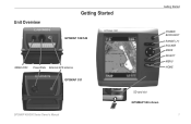
Unit Overview Getting Started GPSMAP 536/546 NMEA 2000 Power/Data External GPS antenna GPSMAP 531 GPSMAP 400/500 Series Owner's Manual Getting Started POWER/ BACKLIGHT RANGE (-/+) ROCKER MARK SELECT MENU HOME SD card slot GPSMAP 546 shown 1
Unit Overview Getting Started GPSMAP 536/546 NMEA 2000 Power/Data External GPS antenna GPSMAP 531 GPSMAP 400/500 Series Owner's Manual Getting Started POWER/ BACKLIGHT RANGE (-/+) ROCKER MARK SELECT MENU HOME SD card slot GPSMAP 546 shown 1
Owner's Manual
Page 35
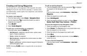
...From the Home screen, select Information > User Data > Waypoints. 2. Select the waypoint you want to 1,500 waypoints (3,000 waypoints for models GPSMAP 431/441/531/541/536/546, including "s" models) with a user-defined name, symbol, depth, water temperature, and comment for the waypoint you want to... edit. 4. Select Move. 5. GPSMAP 400/500 Series Owner's Manual 29 Note: Selecting MARK creates a waypoint only at your current location as a ...
...From the Home screen, select Information > User Data > Waypoints. 2. Select the waypoint you want to 1,500 waypoints (3,000 waypoints for models GPSMAP 431/441/531/541/536/546, including "s" models) with a user-defined name, symbol, depth, water temperature, and comment for the waypoint you want to... edit. 4. Select Move. 5. GPSMAP 400/500 Series Owner's Manual 29 Note: Selecting MARK creates a waypoint only at your current location as a ...
Owner's Manual
Page 36
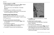
... step to start the new route. Select Review > Delete (The Review button is only shown when more than one waypoint is complete. 30 GPSMAP 400/500 Series Owner's Manual Press SELECT. From the Home screen, select Information > User Data > Routes > New Route. 2. Where To? Choose the location of the first...2. To create a route in the vicinity.) Creating and Using Routes You can create and store up to 20 routes (100 routes for models GPSMAP 431/441/531/541/536/546, including "s" models), with up to delete. 3. If you want to 250 waypoints each. Repeat until the route is in ...
... step to start the new route. Select Review > Delete (The Review button is only shown when more than one waypoint is complete. 30 GPSMAP 400/500 Series Owner's Manual Press SELECT. From the Home screen, select Information > User Data > Routes > New Route. 2. Where To? Choose the location of the first...2. To create a route in the vicinity.) Creating and Using Routes You can create and store up to 20 routes (100 routes for models GPSMAP 431/441/531/541/536/546, including "s" models), with up to delete. 3. If you want to 250 waypoints each. Repeat until the route is in ...
Owner's Manual
Page 47
... using WAAS or EGNOS, the device takes longer to brighten or darken the backlight. A Garmin Product Support representative may ask you to use this feature to set when the unit makes ... satellite constellation. • WAAS/EGNOS-toggle WAAS (in North America) or EGNOS GPSMAP 400/500 Series Owner's Manual Configuring the Chartplotter (in Europe) on or off with the Power Key before power...time for depth, temperature, distance, speed, elevation, volume, and pressure. 41 Auto Power (GPSMAP 431/441/531/541/536/546, including "s" models)-turn Simulator mode (page 6) on whenever power is ...
... using WAAS or EGNOS, the device takes longer to brighten or darken the backlight. A Garmin Product Support representative may ask you to use this feature to set when the unit makes ... satellite constellation. • WAAS/EGNOS-toggle WAAS (in North America) or EGNOS GPSMAP 400/500 Series Owner's Manual Configuring the Chartplotter (in Europe) on or off with the Power Key before power...time for depth, temperature, distance, speed, elevation, volume, and pressure. 41 Auto Power (GPSMAP 431/441/531/541/536/546, including "s" models)-turn Simulator mode (page 6) on whenever power is ...
Owner's Manual
Page 56
Depth Temperature Speed Suspended targets Transducer frequency or beam width Full Screen Range 50 GPSMAP 400/500 Series Owner's Manual From the Home screen, select Sonar > Full Screen. Using Sonar Using Sonar When connected to a transducer, the following chartplotters can be used as fishfinders: GPSMAP 430s GPSMAP 431s GPSMAP 530s GPSMAP 531s GPSMAP 540s GPSMAP 541s GPSMAP 440s GPSMAP 441s GPSMAP 535s GPSMAP 536s GPSMAP 545s GPSMAP 546s Understanding the Full Screen Select the Full Screen option to view a full-screen graph of the transducer's sonar readings.
Depth Temperature Speed Suspended targets Transducer frequency or beam width Full Screen Range 50 GPSMAP 400/500 Series Owner's Manual From the Home screen, select Sonar > Full Screen. Using Sonar Using Sonar When connected to a transducer, the following chartplotters can be used as fishfinders: GPSMAP 430s GPSMAP 431s GPSMAP 530s GPSMAP 531s GPSMAP 540s GPSMAP 541s GPSMAP 440s GPSMAP 441s GPSMAP 535s GPSMAP 536s GPSMAP 545s GPSMAP 546s Understanding the Full Screen Select the Full Screen option to view a full-screen graph of the transducer's sonar readings.
Owner's Manual
Page 75
... × 480 pixels, capable of 4,096 colors. diagonal (12.7 cm), QVGA display with adjustable brightness, 320 × 234 pixels. GPSMAP 431/431s GPSMAP 441/441s GPSMAP 531/531s GPSMAP 541/541s High-sensitivity, 12 parallel channel, WAAS-capable receiver. Appendix Specifications Physical Specifications Size : 400 Series: W × H ×... in. (15.0 cm × 16.3 cm × 7.4 cm) Weight: 400 Series: 1.30 lb. (560 g) 500 Series: 1.75 lb. (800 g) Display: GPSMAP 430/431/440/441: 4.0 in . GPSMAP 536/536s GPSMAP 546/546s Update Rate: once per second GPSMAP 400/500 Series Owner's Manual 69
... × 480 pixels, capable of 4,096 colors. diagonal (12.7 cm), QVGA display with adjustable brightness, 320 × 234 pixels. GPSMAP 431/431s GPSMAP 441/441s GPSMAP 531/531s GPSMAP 541/541s High-sensitivity, 12 parallel channel, WAAS-capable receiver. Appendix Specifications Physical Specifications Size : 400 Series: W × H ×... in. (15.0 cm × 16.3 cm × 7.4 cm) Weight: 400 Series: 1.30 lb. (560 g) 500 Series: 1.75 lb. (800 g) Display: GPSMAP 430/431/440/441: 4.0 in . GPSMAP 536/536s GPSMAP 546/546s Update Rate: once per second GPSMAP 400/500 Series Owner's Manual 69
Owner's Manual
Page 76
... receiver with a clear view of the sky.) GPSMAP 430/430s GPSMAP 440/440s GPSMAP 530/530s GPSMAP 535/535s GPSMAP 530/540s GPSMAP 535/545s Warm:* Approximately 15 seconds Cold:** Approximately 45 seconds GPSMAP 431/431s GPSMAP 441/441s GPSMAP 531/531s GPSMAP 541/541s Warm:* Approximately 1 second Cold:** Approximately 38 seconds GPSMAP 536/536s GPSMAP 546/546s Warm:* Approximately 15 seconds Cold:** Approximately...
... receiver with a clear view of the sky.) GPSMAP 430/430s GPSMAP 440/440s GPSMAP 530/530s GPSMAP 535/535s GPSMAP 530/540s GPSMAP 535/545s Warm:* Approximately 15 seconds Cold:** Approximately 45 seconds GPSMAP 431/431s GPSMAP 441/441s GPSMAP 531/531s GPSMAP 541/541s Warm:* Approximately 1 second Cold:** Approximately 38 seconds GPSMAP 536/536s GPSMAP 546/546s Warm:* Approximately 15 seconds Cold:** Approximately...


